The First Mate's Journal
Where to next?
Great Lakes to The Bahamas
Who: Wayne & Pat
Port: Jackson
Favorites
05 November 2009 | Deltaville, VA
16 October 2009 | Deltaville, VA
27 May 2009 | Deltaville
26 May 2009 | Deltaville
25 May 2009 | Deltaville
24 May 2009 | Fishing Bay (N37*32.418 W76*20.203) to Deltaville
23 May 2009 | Great Bridge VA (N36*43.285 W76*14.508) to Fishing Bay VA (N37*32.418 W76*20.203)
22 May 2009 | Buck Island, NC (N36*16.034 W75*57.520) to Great BridgeVA (N36*43.285 W76*14.508)
21 May 2009 | The Alligator River Bridge, NC (N35*53.847 W76*02.024) to Buck Island, NC (N36*16.034 W75*57.520)
20 May 2009 | Alligator River Bridge, NC
19 May 2009 | Alligator River Swing Bridge, NC
17 May 2009 | The Pungo River, NC (N35*33.715 W76*28.557) to Alligator Swing Bridge, NC (N35*53.874 W76*02.024)
16 May 2009 | Eastham Creek Anchorage NC (N35*17.680 W76*36.514) to The Pungo River, NC (N35*33.715 W76*28.557)
15 May 2009 | Town Creek Marina, Beaufort NC (N34*43.519 W76*39.898) to Eastham Creek, NC (N35*17.680 W76*36.514)
14 May 2009 | Town Creek Marina, Beaufort, NC
13 May 2009 | Taylor Creek, Beaufort, NC (34*42.860 76*39.831) to Town Creek Marina, Beaufort, NC
12 May 2009 | Mile Hammock Bay (N34*33.163 W77*19.528) SM#244.5 to Taylor Creek, Beaufort, NC (34*42.860 76*39.831)
11 May 2009 | Wrightsville Beach NC (N34*12.441 W77*47.965) SM#283.2 to Mile Hammock Bay (N34*33.163 W77*19.528) SM#244.5
10 May 2009 | Shallottes Inlet, NC (N33*54.913)SM330 to Wrightsville Beach Anchorage (N34*12.447 W77*47.953)
09 May 2009 | Bull Creek, SC (N33 36.667 W79 06.228) to Shallottes Inlet, NC (N33*54.913)
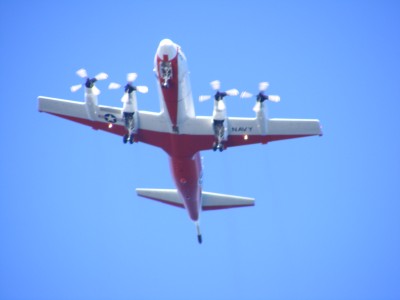
All the antennas - is it Seti?
20 October 2008 | Mill Creek, Patuxent River, MD (38o20.10 x 76o30.162) to anchorage between Seldom and Sloop Points on the Yeocomico River, MD (38o01.815 x 076o33.969)
Sunny, High-pressure, upper 60s, waves 1-3 ft.
It got downright frigid last night - 37 degrees. There's condensation on all the ports and as I rub my sleeve across one window and look out, I see steam rising from sections of water portside, and a layer of fog blankets the water to the starboard side of the boat. The sky is pink where the sun should be rising and it is cold in the boat. Time to kick on the heat and jump back into bed for 10 minutes after pouring water into the coffee pot and lighting the burner... Brrrr. Watch out Wayne, here come the cold feet Ha ha ha...
After coffee we hoisted the anchor and I made grilled cheese and tomato sandwiches for breakfast (just because...) and we threaded our way back out of the creek to the Patuxent river, then back to the Chesapeake and headed toward the Yeocomico River. Destination roughly 38 miles.
Along the way we saw a huge group of antennas, radar, etc... and it turned out to be part of the Patuxent Naval Air Station. One plane doing touch and goes was a Naval mid-air tanker (the kind that refuels planes in the air) He came right over us very low one time as we approached the restricted bombing range and a fighter plane also left the base (very fast, very loud). It was very cool watching the trainers - kind of the next stage for the cadets we saw at the Naval Academy. We'd learned that the Navy actually has more planes than the AirForce does - imagine that!
Speaking of the bombing range - we saw our first pelicans today next to the bombing range! It seems mighty cold here still for pelican's to be showing up already! Hopefully it means we're making progress south.
The Potomac is much bigger than I pictured. At the mouth it appears to be about 10 miles across, and it snakes up quite far. Captain Wayne would love to take our little boat up and park her near some monuments if we didn't have the cold weather barking at our heals. There's a lot of history and area to explore that we're just passing by. The Chesapeake alone is 200 miles long, and there is soooo much to explore. It's a veritable gunkholers heaven passing through 3 states, with tons of crab, oyster and fish boats to watch, and now looking at the Potomac and thinking about it's history. Amazing to visualize the British sailing ships moving up these same waters that we're passing through on this beautiful fall afternoon.
We pulled into the Yeocomico River towards the marina for gas at 4:01pm and hailed the marina but got no response. They either closed at 4:00 or are already closed for the season I guess, so we went to the next cove up between Sloop and Seldom Points and dropped anchor. It's beautiful here. The trees are in color, the peepers are chirping, a blue heron is fishing on the shore and a king fisher is hailing another in a tree branch on the water's edge. The bottom of the cove is a very fine black silt that the anchor doesn't want to set well in, but it's so calm and protected, Wayne doesn't think we'll have a problem in here. There's a chill in the air but the smell and crispness reminds me of home. Maybe it's the trees along the water and the color change too.
The oven cooperated nicely this evening in reheating the meat pie from last night. Much better now that the alcohol in it has been replenished. Wayne just finished reading me an article on a couple transiting the Southern Ocean, and it's time for bed (I want to get under the covers). After listening to him, now I'm really cold.
Comments
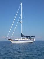
| Vessel Name: | Kolibrie |
| Vessel Make/Model: | Bayfield 36 |
| Hailing Port: | Jackson |
| Crew: | Wayne & Pat |
| About: | Back in Michigan for Hurricane Season 2009... |
| Extra: | Our boat is a Bayfield 36. Not the fastest little thing, but a nice little cruiser that we like to call home. |
| Home Page: | www.kolibrie.us |
Gallery not available
Great Lakes to The Bahamas
Who: Wayne & Pat
Port: Jackson