The First Mate's Journal
Where to next?
Great Lakes to The Bahamas
Who: Wayne & Pat
Port: Jackson
Favorites
05 November 2009 | Deltaville, VA
16 October 2009 | Deltaville, VA
27 May 2009 | Deltaville
26 May 2009 | Deltaville
25 May 2009 | Deltaville
24 May 2009 | Fishing Bay (N37*32.418 W76*20.203) to Deltaville
23 May 2009 | Great Bridge VA (N36*43.285 W76*14.508) to Fishing Bay VA (N37*32.418 W76*20.203)
22 May 2009 | Buck Island, NC (N36*16.034 W75*57.520) to Great BridgeVA (N36*43.285 W76*14.508)
21 May 2009 | The Alligator River Bridge, NC (N35*53.847 W76*02.024) to Buck Island, NC (N36*16.034 W75*57.520)
20 May 2009 | Alligator River Bridge, NC
19 May 2009 | Alligator River Swing Bridge, NC
17 May 2009 | The Pungo River, NC (N35*33.715 W76*28.557) to Alligator Swing Bridge, NC (N35*53.874 W76*02.024)
16 May 2009 | Eastham Creek Anchorage NC (N35*17.680 W76*36.514) to The Pungo River, NC (N35*33.715 W76*28.557)
15 May 2009 | Town Creek Marina, Beaufort NC (N34*43.519 W76*39.898) to Eastham Creek, NC (N35*17.680 W76*36.514)
14 May 2009 | Town Creek Marina, Beaufort, NC
13 May 2009 | Taylor Creek, Beaufort, NC (34*42.860 76*39.831) to Town Creek Marina, Beaufort, NC
12 May 2009 | Mile Hammock Bay (N34*33.163 W77*19.528) SM#244.5 to Taylor Creek, Beaufort, NC (34*42.860 76*39.831)
11 May 2009 | Wrightsville Beach NC (N34*12.441 W77*47.965) SM#283.2 to Mile Hammock Bay (N34*33.163 W77*19.528) SM#244.5
10 May 2009 | Shallottes Inlet, NC (N33*54.913)SM330 to Wrightsville Beach Anchorage (N34*12.447 W77*47.953)
09 May 2009 | Bull Creek, SC (N33 36.667 W79 06.228) to Shallottes Inlet, NC (N33*54.913)
Travel area notes
02 November 2008 | South Lake/Little Alligator River (35*55.052 x 075*54.548) End 4:15pm Pungo River Anchorage depth 10 ft at anchor (35*33.608x076*28.258)
T 43* P 30.29r, Dpt 42, W NE 5-10, Hi T 70
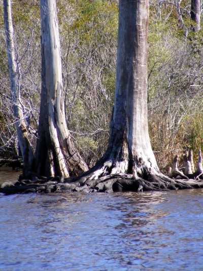
What a beautiful traveling day! It started out on the cold side with our foul weather jackets on, and we ended up in t-shirts. What beautiful scenery along the cut here. There's a variety of trees, bushes and marsh grass but the most distinctive thing that I couldn't seem to keep my camera off of was the bald cypress and dead stumps in the water. The light color of the wood just stood out from the dark green evergreen bushes and yellow/greens of the grass. Throw in the dark brown/red water that they stand in, and Patti was snapping pictures left and right. Rob asked me to send pictures but lordy I wouldn't know where to start...
Speaking of the water here - The dark coffee color comes from tannin. It's released from the roots and decaying leaves of the juniper and bald cypress trees along the water and gives all the boats a mustache on their bow that come through the ICW. While the water looks dirty, it's not. Per the Doyle's in "Managing the Waterway" the old ships used to seek out water with tannin as it wouldn't spoil as easily. It increased the acidity of the water they stored in their scuttlebutts (wood barrels) so it wouldn't become buggy as quickly as water without it. I found that fact interesting and somehow comforting. Before reading about the color, it felt like we were traveling through dark muddy water...
The rivers, sounds, oxbows and cuts all seem to have their own personalities/ecosystems. The bald cypresses along here intrigue me. Their gnarled branches and roots look so old and fragile but the wood is a type of redwood that is resistant to rot. It's seldom harvested now because it's so slow to grow, but was liberally harvested in the past for use in hulls, coffins and as fence posts. These and other pines and conifers are good judges as to the amount of salt present in the water in the areas that we pass through. They're not salt tolerant so the more skeletons of cypress that we see, the saltier the water is. It's interesting to note how in some areas, you'll see the dead trees, then grasses teeming along the shore with the pines standing way further back or further uphill. As I recall, this area also has floating bogs (per my MS State fieldtrip to the Carolinas). I wish I'd have brought my field notes from 2 years ago now (I totally forgot them). I'll have to go by memory but it's good to see that it's still in my thoughts too.
Comments
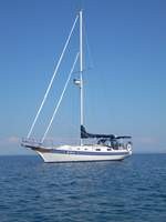
| Vessel Name: | Kolibrie |
| Vessel Make/Model: | Bayfield 36 |
| Hailing Port: | Jackson |
| Crew: | Wayne & Pat |
| About: | Back in Michigan for Hurricane Season 2009... |
| Extra: | Our boat is a Bayfield 36. Not the fastest little thing, but a nice little cruiser that we like to call home. |
| Home Page: | www.kolibrie.us |
Gallery not available
Great Lakes to The Bahamas
Who: Wayne & Pat
Port: Jackson