The First Mate's Journal
Where to next?
Great Lakes to The Bahamas
Who: Wayne & Pat
Port: Jackson
Favorites
05 November 2009 | Deltaville, VA
16 October 2009 | Deltaville, VA
27 May 2009 | Deltaville
26 May 2009 | Deltaville
25 May 2009 | Deltaville
24 May 2009 | Fishing Bay (N37*32.418 W76*20.203) to Deltaville
23 May 2009 | Great Bridge VA (N36*43.285 W76*14.508) to Fishing Bay VA (N37*32.418 W76*20.203)
22 May 2009 | Buck Island, NC (N36*16.034 W75*57.520) to Great BridgeVA (N36*43.285 W76*14.508)
21 May 2009 | The Alligator River Bridge, NC (N35*53.847 W76*02.024) to Buck Island, NC (N36*16.034 W75*57.520)
20 May 2009 | Alligator River Bridge, NC
19 May 2009 | Alligator River Swing Bridge, NC
17 May 2009 | The Pungo River, NC (N35*33.715 W76*28.557) to Alligator Swing Bridge, NC (N35*53.874 W76*02.024)
16 May 2009 | Eastham Creek Anchorage NC (N35*17.680 W76*36.514) to The Pungo River, NC (N35*33.715 W76*28.557)
15 May 2009 | Town Creek Marina, Beaufort NC (N34*43.519 W76*39.898) to Eastham Creek, NC (N35*17.680 W76*36.514)
14 May 2009 | Town Creek Marina, Beaufort, NC
13 May 2009 | Taylor Creek, Beaufort, NC (34*42.860 76*39.831) to Town Creek Marina, Beaufort, NC
12 May 2009 | Mile Hammock Bay (N34*33.163 W77*19.528) SM#244.5 to Taylor Creek, Beaufort, NC (34*42.860 76*39.831)
11 May 2009 | Wrightsville Beach NC (N34*12.441 W77*47.965) SM#283.2 to Mile Hammock Bay (N34*33.163 W77*19.528) SM#244.5
10 May 2009 | Shallottes Inlet, NC (N33*54.913)SM330 to Wrightsville Beach Anchorage (N34*12.447 W77*47.953)
09 May 2009 | Bull Creek, SC (N33 36.667 W79 06.228) to Shallottes Inlet, NC (N33*54.913)
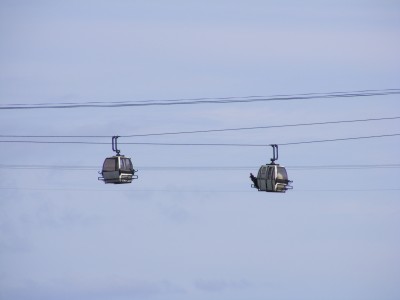
Ski Lifts???
24 November 2008 | Coquina Harbor (33 51.852 x -78 38.295) to Waccama River/ Bull Creek Anchorage (33 36.664 x �79 06.151) 10 ft depth
Today we maneuvered through the infamous Rock Pile. I kept calling it the "Dog Pile" - don't ask, I don't know why... Wayne kept making fun of me for it. Since I'm a geologist by training, you'd think the name "Rock Pile" would be a no-brainer for me to remember! Since it was close to low tide, then low tide, the ledges were visible and quite intimidating. Rock is not something I care to run into, whether its schist (most people think it's schist here) or hardened limestone, either is not kindly to a boat.
We followed a couple of other sailboats (loosely) for a while. Actually they passed us and got further ahead, but then at the swing bridge (Barefoot Bridge) the bridge tender held everyone up until we got there (he could see us coming) and I felt badly so tried to turn up the speed so they wouldn't have to wait. No need to have worried though because I got up there when the bridge was scheduled to open really Vroom vroom...
Past the bridge (Myrtle Beach way) it began to amaze me... They had docks along the side so you could tie up and go shopping in mega malls, eat in upscale or downscale restaurants, huge condos, yacht clubs and marinas. After passing by them, I had to look them up and found that the docks there were free to use and in season people raft together with 4 across to spend the night and shop and party... flabbergasted me but a very good ploy to get the cruisers to stop and spend their money. Very smart indeed! Had I known ahead we'd have tied up here for the night (hey what woman doesn't like spending money and eating out sometimes). It was interesting to note that the further along this stretch we went, the bigger the houses and condos became. Some had their own golf courses - speaking of which - we passed this one golf course that had an aerial tramway to take golfers across the waterway to the greens - just like ski lifts! I originally saw these ski lifts crossing the waterway and thought "Wow" ski slopes here? It's not that cold yet! But when we got closer I could see it was a golf course... talk about a posh golf course/club LOL
We anchored at 4:03 in Bull Creek (no bull!) in 10-11 ft of water on the inside part of the bend of a meander where it was shallower and the current not as swift. It's a pretty area, wild looking and isolated. Surveyor, a trawler we saw and passed earlier came around the bend, as we were finishing up anchoring, and anchored behind us for the night. I love these quiet anchorages. There's a lot of Spanish moss in this area hanging in the trees (live oak) and we passed by a lot of areas that look like rice grasses today. The Spanish moss looks dead but in reality it isn't. It's an air plant from the pineapple family that lives off the moisture from the air and rain. People used to use it for making rope, gun wadding and bedding for upholstery during the revolutionary war. I don't know that it's used much for anything anymore but it looks dramatic hanging from the trees...
Comments
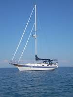
| Vessel Name: | Kolibrie |
| Vessel Make/Model: | Bayfield 36 |
| Hailing Port: | Jackson |
| Crew: | Wayne & Pat |
| About: | Back in Michigan for Hurricane Season 2009... |
| Extra: | Our boat is a Bayfield 36. Not the fastest little thing, but a nice little cruiser that we like to call home. |
| Home Page: | www.kolibrie.us |
Gallery not available
Great Lakes to The Bahamas
Who: Wayne & Pat
Port: Jackson