The First Mate's Journal
Where to next?
Great Lakes to The Bahamas
Who: Wayne & Pat
Port: Jackson
Favorites
05 November 2009 | Deltaville, VA
16 October 2009 | Deltaville, VA
27 May 2009 | Deltaville
26 May 2009 | Deltaville
25 May 2009 | Deltaville
24 May 2009 | Fishing Bay (N37*32.418 W76*20.203) to Deltaville
23 May 2009 | Great Bridge VA (N36*43.285 W76*14.508) to Fishing Bay VA (N37*32.418 W76*20.203)
22 May 2009 | Buck Island, NC (N36*16.034 W75*57.520) to Great BridgeVA (N36*43.285 W76*14.508)
21 May 2009 | The Alligator River Bridge, NC (N35*53.847 W76*02.024) to Buck Island, NC (N36*16.034 W75*57.520)
20 May 2009 | Alligator River Bridge, NC
19 May 2009 | Alligator River Swing Bridge, NC
17 May 2009 | The Pungo River, NC (N35*33.715 W76*28.557) to Alligator Swing Bridge, NC (N35*53.874 W76*02.024)
16 May 2009 | Eastham Creek Anchorage NC (N35*17.680 W76*36.514) to The Pungo River, NC (N35*33.715 W76*28.557)
15 May 2009 | Town Creek Marina, Beaufort NC (N34*43.519 W76*39.898) to Eastham Creek, NC (N35*17.680 W76*36.514)
14 May 2009 | Town Creek Marina, Beaufort, NC
13 May 2009 | Taylor Creek, Beaufort, NC (34*42.860 76*39.831) to Town Creek Marina, Beaufort, NC
12 May 2009 | Mile Hammock Bay (N34*33.163 W77*19.528) SM#244.5 to Taylor Creek, Beaufort, NC (34*42.860 76*39.831)
11 May 2009 | Wrightsville Beach NC (N34*12.441 W77*47.965) SM#283.2 to Mile Hammock Bay (N34*33.163 W77*19.528) SM#244.5
10 May 2009 | Shallottes Inlet, NC (N33*54.913)SM330 to Wrightsville Beach Anchorage (N34*12.447 W77*47.953)
09 May 2009 | Bull Creek, SC (N33 36.667 W79 06.228) to Shallottes Inlet, NC (N33*54.913)
Continuation of 12/6/08 - long day
07 December 2008 | SC to FL
Continued from 12/6/08
We're bypassing Georgia this trip for several reasons. From what we've heard the shoaling is pretty bad there this year. So the transits have to be done carefully by moving along at high tide to avoid grounding. The tides in Georgia are notorious at 9 ft variances. Add 9-foot tides to having to time those with the bridge openings and it could become a logistical problem. Hence it's easier for us to just go outside and around Georgia - we like easy when possible - and hopefully we'll be able to visit her again in the future when we have more time or it's earlier in the season (it's colllld).
On schedule after midnight the winds and waves started their dance with us and the temperatures really plummeted. Having the auto helm on for the 3rd time in our history with the boat, really helped. We could stand up or sit under the dodger and monitor our progress with the chart plotter and radar, and adjust our course accordingly. Our gray sky cleared to show us Orion, and I could see our beautiful red star Mars sitting low in the sky (yes I know - Mars isn't a star but it's easy to pick out because of its tint). We'd been motor sailing with a reef in the main and at times our speed hit 9 knots even with dumping some of the air out of the sails. We hit the St Mary's Channel way before dawn and with the waves, winds, and cold temperatures we had to try and slowly make our way into the channel in the dark, there was no way to stay out - we could have gone on to St John's another 35 miles further on, but were unsure of our gas since we didn't start with a full tank and were still doubtful as to how much our tanks actually hold. I went below to heat more water to warm us before we tried to figure out what to do, when Wayne called me back up to take the helm so he could drop the sail. We were still pushing past 9 - 9.5 knots. So we headed into the wind in the dark and dropped the sail. It's amazing how much stability that sail gave us, and as soon as we dropped it, it became apparent. The rest of the morning was spent freezing at the helm trying to see where I was going past a flapping sail to the side, the dingy in the front and the wind and waves over the other side. It was not a pleasant condition to be in to say the least. I found a range going into the channel but most of the time couldn't see it between the pitching waves, flopping sail and salt glasses. I had left my gloves below and my hands were numb. Wayne couldn't see, couldn't go below to find the chart, or uptop to lash down the sail so he sat at the chart plotter while I tried to keep us on course and off the sediment traps, buoys and worse still from running into any buoys or rocks or anything else to the side of the channels.
Once we got inside it was still to dark to safely navigate and the shadows on the water were scary. I ended up right next to a dredger with two tugs attached to it and circled it in 6.5 feet of water. Wayne said the chart plotter was reading 3 ft, and to move over. I was screaming do you see that dredger!! I can't go through him or over his hoses. I was so close to him that I could have jumped from our bridge to his and hoped that they weren't awake to hear us yelling at each other to be heard over the engine and wind.
I was finally able to slow to 2.5 to 3 knots and slowly idle down the channel as the sun started to lighten the sky and we were able to find an anchorage and drop the hook at 7:15am 4 minutes after sunrise.
The plan was to get into the harbor in 24 hours and we got in, in 21 hours. Time for some much needed warmth and sleep...
Comments
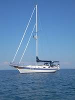
| Vessel Name: | Kolibrie |
| Vessel Make/Model: | Bayfield 36 |
| Hailing Port: | Jackson |
| Crew: | Wayne & Pat |
| About: | Back in Michigan for Hurricane Season 2009... |
| Extra: | Our boat is a Bayfield 36. Not the fastest little thing, but a nice little cruiser that we like to call home. |
| Home Page: | www.kolibrie.us |
Gallery not available
Great Lakes to The Bahamas
Who: Wayne & Pat
Port: Jackson