The First Mate's Journal
Where to next?
Great Lakes to The Bahamas
Who: Wayne & Pat
Port: Jackson
Favorites
05 November 2009 | Deltaville, VA
16 October 2009 | Deltaville, VA
27 May 2009 | Deltaville
26 May 2009 | Deltaville
25 May 2009 | Deltaville
24 May 2009 | Fishing Bay (N37*32.418 W76*20.203) to Deltaville
23 May 2009 | Great Bridge VA (N36*43.285 W76*14.508) to Fishing Bay VA (N37*32.418 W76*20.203)
22 May 2009 | Buck Island, NC (N36*16.034 W75*57.520) to Great BridgeVA (N36*43.285 W76*14.508)
21 May 2009 | The Alligator River Bridge, NC (N35*53.847 W76*02.024) to Buck Island, NC (N36*16.034 W75*57.520)
20 May 2009 | Alligator River Bridge, NC
19 May 2009 | Alligator River Swing Bridge, NC
17 May 2009 | The Pungo River, NC (N35*33.715 W76*28.557) to Alligator Swing Bridge, NC (N35*53.874 W76*02.024)
16 May 2009 | Eastham Creek Anchorage NC (N35*17.680 W76*36.514) to The Pungo River, NC (N35*33.715 W76*28.557)
15 May 2009 | Town Creek Marina, Beaufort NC (N34*43.519 W76*39.898) to Eastham Creek, NC (N35*17.680 W76*36.514)
14 May 2009 | Town Creek Marina, Beaufort, NC
13 May 2009 | Taylor Creek, Beaufort, NC (34*42.860 76*39.831) to Town Creek Marina, Beaufort, NC
12 May 2009 | Mile Hammock Bay (N34*33.163 W77*19.528) SM#244.5 to Taylor Creek, Beaufort, NC (34*42.860 76*39.831)
11 May 2009 | Wrightsville Beach NC (N34*12.441 W77*47.965) SM#283.2 to Mile Hammock Bay (N34*33.163 W77*19.528) SM#244.5
10 May 2009 | Shallottes Inlet, NC (N33*54.913)SM330 to Wrightsville Beach Anchorage (N34*12.447 W77*47.953)
09 May 2009 | Bull Creek, SC (N33 36.667 W79 06.228) to Shallottes Inlet, NC (N33*54.913)
As the ICW draws to a close for us...
09 February 2009 | N25*47.496 W80*09.932
72* Mostly sunny ENE winds 15mph
Okay, at 3pm we're now anchored between San Marco Island and San Marino Island in Biscayne Bay off the Port of Miami. My broadband is still working (but you'd expect that around Miami).
Twelve bridges today... we managed to time them pretty good too. There's a string of islands called the Venetian Causeway before you get to the main channel of the Port of Miami and we're anchored on the north side of the islands. Little bridges link the islands together and looking past the bridge where we are, I can see several huge cruise ships. If there's only one, the Coast Guard will let you use the main channel to get in and out of Miami. But if there's more than one, you have to use the secondary channel south of Dodge Island. So we'll see which one we'll be able to use once our weather window gets here. We saw 4-5 other sailboats pull out of Las Olas this morning when we left our mooring and a couple others left before we did. The majority went outside but we'd decided to stay on the ICW to finish our tenure on the ICW to mile marker 1090. The Julia Tuttle Bridge (one of the reasons a lot of boats go outside to get to Miami) is a fixed vertical height of 56 ft so any sailboats with tall masts have to go outside to get to Miami. We managed to squeak under without scraping any of our antennas LOL. It looked tight from below looking up and we approached the bridge real slow in case we did hit it. We shouldn't have really worried about it though. Our mast height from the water level is 50 ft. Tack on another foot or two for the antennas and we're still fine, but we were nervous nonetheless because we were taking the previous owner's word for the mast ht. Even though he'd left wonderful records and data for us, it's still scary since we didn't measure it ourselves. I guess the person in charge of bridge construction may have been dyslexic because the ht was supposed to be 65 ft (the standard ht of fixed bridges here) - it seems that he/she transposed the numbers.
It seems strange that our trip along the ICW is about at a close. It's scary and exhilarating at the same time. The end of one leg in our journey and the start of the next...
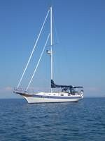
The next step in our journey is to leave the Port of Miami and finally sail away from the North American shore, east across the Gulf Stream, eastward into deep water, toward the islands in the Bahamas. There we are in the picture - okay I know, I know, we're still anchored in the Miami area as I write this - but it's a visual of us when we cross...
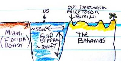
While we've been there before by plane, we've never been there via water, never via our own boat, our little floating home. East of here is a collection of more than 700 islands that sit atop a plateau. As we leave Florida, we'll enter the Gulf Stream waters 896 meters deep (roughly 2986 ft) with northward running currents that travel on average at 3 knots (remember our little boat runs about 6 knots). Then the Bahamas plateau rises suddenly from the depths to a shallow measurement of 2-3 meters (8-10 ft). I can see where this might cause a panic - even knowing in advance - I'll probably still be shocked LOL. I don't know how long we'll be waiting - I think unless the weather patterns change that we're looking at heading out Thursday - we'll see. That's when the predicted winds will change to a southerly direction...
Twelve bridges today... we managed to time them pretty good too. There's a string of islands called the Venetian Causeway before you get to the main channel of the Port of Miami and we're anchored on the north side of the islands. Little bridges link the islands together and looking past the bridge where we are, I can see several huge cruise ships. If there's only one, the Coast Guard will let you use the main channel to get in and out of Miami. But if there's more than one, you have to use the secondary channel south of Dodge Island. So we'll see which one we'll be able to use once our weather window gets here. We saw 4-5 other sailboats pull out of Las Olas this morning when we left our mooring and a couple others left before we did. The majority went outside but we'd decided to stay on the ICW to finish our tenure on the ICW to mile marker 1090. The Julia Tuttle Bridge (one of the reasons a lot of boats go outside to get to Miami) is a fixed vertical height of 56 ft so any sailboats with tall masts have to go outside to get to Miami. We managed to squeak under without scraping any of our antennas LOL. It looked tight from below looking up and we approached the bridge real slow in case we did hit it. We shouldn't have really worried about it though. Our mast height from the water level is 50 ft. Tack on another foot or two for the antennas and we're still fine, but we were nervous nonetheless because we were taking the previous owner's word for the mast ht. Even though he'd left wonderful records and data for us, it's still scary since we didn't measure it ourselves. I guess the person in charge of bridge construction may have been dyslexic because the ht was supposed to be 65 ft (the standard ht of fixed bridges here) - it seems that he/she transposed the numbers.
It seems strange that our trip along the ICW is about at a close. It's scary and exhilarating at the same time. The end of one leg in our journey and the start of the next...
The next step in our journey is to leave the Port of Miami and finally sail away from the North American shore, east across the Gulf Stream, eastward into deep water, toward the islands in the Bahamas. There we are in the picture - okay I know, I know, we're still anchored in the Miami area as I write this - but it's a visual of us when we cross...
While we've been there before by plane, we've never been there via water, never via our own boat, our little floating home. East of here is a collection of more than 700 islands that sit atop a plateau. As we leave Florida, we'll enter the Gulf Stream waters 896 meters deep (roughly 2986 ft) with northward running currents that travel on average at 3 knots (remember our little boat runs about 6 knots). Then the Bahamas plateau rises suddenly from the depths to a shallow measurement of 2-3 meters (8-10 ft). I can see where this might cause a panic - even knowing in advance - I'll probably still be shocked LOL. I don't know how long we'll be waiting - I think unless the weather patterns change that we're looking at heading out Thursday - we'll see. That's when the predicted winds will change to a southerly direction...
Comments
| Vessel Name: | Kolibrie |
| Vessel Make/Model: | Bayfield 36 |
| Hailing Port: | Jackson |
| Crew: | Wayne & Pat |
| About: | Back in Michigan for Hurricane Season 2009... |
| Extra: | Our boat is a Bayfield 36. Not the fastest little thing, but a nice little cruiser that we like to call home. |
| Home Page: | www.kolibrie.us |
Gallery not available
Great Lakes to The Bahamas
Who: Wayne & Pat
Port: Jackson