The First Mate's Journal
Where to next?
Great Lakes to The Bahamas
Who: Wayne & Pat
Port: Jackson
Favorites
05 November 2009 | Deltaville, VA
16 October 2009 | Deltaville, VA
27 May 2009 | Deltaville
26 May 2009 | Deltaville
25 May 2009 | Deltaville
24 May 2009 | Fishing Bay (N37*32.418 W76*20.203) to Deltaville
23 May 2009 | Great Bridge VA (N36*43.285 W76*14.508) to Fishing Bay VA (N37*32.418 W76*20.203)
22 May 2009 | Buck Island, NC (N36*16.034 W75*57.520) to Great BridgeVA (N36*43.285 W76*14.508)
21 May 2009 | The Alligator River Bridge, NC (N35*53.847 W76*02.024) to Buck Island, NC (N36*16.034 W75*57.520)
20 May 2009 | Alligator River Bridge, NC
19 May 2009 | Alligator River Swing Bridge, NC
17 May 2009 | The Pungo River, NC (N35*33.715 W76*28.557) to Alligator Swing Bridge, NC (N35*53.874 W76*02.024)
16 May 2009 | Eastham Creek Anchorage NC (N35*17.680 W76*36.514) to The Pungo River, NC (N35*33.715 W76*28.557)
15 May 2009 | Town Creek Marina, Beaufort NC (N34*43.519 W76*39.898) to Eastham Creek, NC (N35*17.680 W76*36.514)
14 May 2009 | Town Creek Marina, Beaufort, NC
13 May 2009 | Taylor Creek, Beaufort, NC (34*42.860 76*39.831) to Town Creek Marina, Beaufort, NC
12 May 2009 | Mile Hammock Bay (N34*33.163 W77*19.528) SM#244.5 to Taylor Creek, Beaufort, NC (34*42.860 76*39.831)
11 May 2009 | Wrightsville Beach NC (N34*12.441 W77*47.965) SM#283.2 to Mile Hammock Bay (N34*33.163 W77*19.528) SM#244.5
10 May 2009 | Shallottes Inlet, NC (N33*54.913)SM330 to Wrightsville Beach Anchorage (N34*12.447 W77*47.953)
09 May 2009 | Bull Creek, SC (N33 36.667 W79 06.228) to Shallottes Inlet, NC (N33*54.913)
It looks like a go for tomorrow
13 February 2009 | Miami, Fl
82 and mostly sunny
Friday, February 13, 2009
Well after listening to the weather and looking at the weather patterns on the web in the morning and this evening it looks like we'll be leaving in the morning ~ 4am so we can make the Bahama Banks by 3pm in order to be able to see the coral heads and shallows in the right lights. 2pm would be better but we'll work with 3 LOL.
So today was a workday. We dinghied over to the Miami Marina near Government Cut to fill up our Diesel cans, then hauled water (3 trips to the police station) to top off our water and get a little extra (stored in the tub) so we wouldn't have to pay for it as soon once down there. Next the dinghy emptied, engine off it and onto the boat rail, then dinghy on the boat deck, course calculated, and plotted from Government Cut to Bimini and entered into the chart plotter; everything stowed away again.
So our tentative itinerary (weather permitting) is tomorrow we head for Bimini and clear customs there. Depending on how many boaters are there (we heard it's a favorite power boat destination and it's a holiday weekend) we may be there one or two days. From there we're planning on heading to Chub Cay but may anchor on the bank before getting there depending on the time/weather element. From Chub Cay we'll head south to Andros Island. There's a place called Morgan's Bluff we've heard about on Andros so we'll probably stay a couple days there and from there we'll either head further south on Andros to Fresh Creek or cut across to New Providence to the West End. After that we'll head further south into the Exumas but aren't sure which islands yet.
Because Internet and wireless are poor to nil there - we'll be out of communication until I can find areas. I'll post more to the journal when I'm able and will try and stay in contact and check my email as often as possible.
I'm nervous and excited to start this next chapter - hope I can get some sleep before the alarm goes off at 3 am...
Love and hugs to all!
Comments
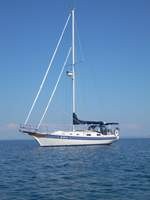
| Vessel Name: | Kolibrie |
| Vessel Make/Model: | Bayfield 36 |
| Hailing Port: | Jackson |
| Crew: | Wayne & Pat |
| About: | Back in Michigan for Hurricane Season 2009... |
| Extra: | Our boat is a Bayfield 36. Not the fastest little thing, but a nice little cruiser that we like to call home. |
| Home Page: | www.kolibrie.us |
Gallery not available
Great Lakes to The Bahamas
Who: Wayne & Pat
Port: Jackson