The First Mate's Journal
Where to next?
Great Lakes to The Bahamas
Who: Wayne & Pat
Port: Jackson
Favorites
05 November 2009 | Deltaville, VA
16 October 2009 | Deltaville, VA
27 May 2009 | Deltaville
26 May 2009 | Deltaville
25 May 2009 | Deltaville
24 May 2009 | Fishing Bay (N37*32.418 W76*20.203) to Deltaville
23 May 2009 | Great Bridge VA (N36*43.285 W76*14.508) to Fishing Bay VA (N37*32.418 W76*20.203)
22 May 2009 | Buck Island, NC (N36*16.034 W75*57.520) to Great BridgeVA (N36*43.285 W76*14.508)
21 May 2009 | The Alligator River Bridge, NC (N35*53.847 W76*02.024) to Buck Island, NC (N36*16.034 W75*57.520)
20 May 2009 | Alligator River Bridge, NC
19 May 2009 | Alligator River Swing Bridge, NC
17 May 2009 | The Pungo River, NC (N35*33.715 W76*28.557) to Alligator Swing Bridge, NC (N35*53.874 W76*02.024)
16 May 2009 | Eastham Creek Anchorage NC (N35*17.680 W76*36.514) to The Pungo River, NC (N35*33.715 W76*28.557)
15 May 2009 | Town Creek Marina, Beaufort NC (N34*43.519 W76*39.898) to Eastham Creek, NC (N35*17.680 W76*36.514)
14 May 2009 | Town Creek Marina, Beaufort, NC
13 May 2009 | Taylor Creek, Beaufort, NC (34*42.860 76*39.831) to Town Creek Marina, Beaufort, NC
12 May 2009 | Mile Hammock Bay (N34*33.163 W77*19.528) SM#244.5 to Taylor Creek, Beaufort, NC (34*42.860 76*39.831)
11 May 2009 | Wrightsville Beach NC (N34*12.441 W77*47.965) SM#283.2 to Mile Hammock Bay (N34*33.163 W77*19.528) SM#244.5
10 May 2009 | Shallottes Inlet, NC (N33*54.913)SM330 to Wrightsville Beach Anchorage (N34*12.447 W77*47.953)
09 May 2009 | Bull Creek, SC (N33 36.667 W79 06.228) to Shallottes Inlet, NC (N33*54.913)
On the Banks Part II
19 February 2009 | Bimini (N25*43.473 W079*17.858) to… anchoring out on the Bahamas Bank (N25*27.010 W078*19.114)
SW winds 20mph seas 2-4 ft 64.9 miles today
Thursday, February 19, 2009
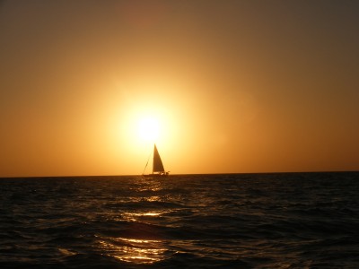
Dscf5347
A little after 2pm Aurora hailed us to say they blew their jib and were slowed up a bit. They were going to motor back up and motor sail so we let some of the power out of our sails so they could catch up. I told them we'd keep an eye out for them, but it was rough letting the wind out of the sails. Kolibrie still wanted to go 6 knots but Wayne got her to slow down to 3-4 knots until Aurora passed us. The winds are still blowing from 15-20mph and we've sped back up a bit to 6.0 knots now that Aurora has gained on us. We're talking about stopping around 5pm but we're so far behind Sooo Fine 2 that we'll probably still be sailing until 7 until we catch up to him LOL. Waves are still in the 2-4 ft range at 4pm. It's an amazing view - looking in any direction all you can see is blue-sky meeting emerald water. No land in sight anywhere. White capped waves of green and blue sky and looking down you can see the sand beneath the water.
After thinking about it, I was wondering if Aurora's sun protector separated from the sail like ours did. If so, it's repairable... So I hailed them on the radio to see if that was the case. They weren't quite sure but I told them if that was the case we had our sewing machine with us because we'd done that last year. If we could find a quiet anchorage to pull it out and look at it, we might be able to repair it. We'll see at the next anchorage - I think we're heading to the same place in the Berry Islands - around the Chub Cay area. The one today won't work because it's all water on the banks.
So Fine 2 picked out some coordinates for us to meet at to anchor for the night and called to verify that it was okay for Aurora and us. It shows 9-10 ft depth so we said okay, then I checked it out, as far as distance, and it was a little over 10 miles, which meant getting in about 6 - 6:30. Wayne cranked on the engine to get our speed up so we could make it in before dark. We pulled in at 6:09 and dropped anchor at sunset. It was almost a 12-hour sail today. 64.9 miles. Depth here is 13 ft. Position: N25*27.010 W078*19.114 It's weird to anchor in such shallow depths with no land in sight anywhere... Feels like "Water World" (the movie). We're anchored 2 miles off of the route to make sure that we're out of the "traffic lane" if there are any boats traveling through the banks tonight. The charts show suggested routes to follow for those unsure of the depths that have 6 ft drafts (I for one appreciate that!).
Salmon in a ginger, soy, garlic, lime and honey sauce with salad and Bimini bread for dinner. Then up top to see the stars. It should be a terrific view of the sky. The only lights are our three anchor lights (Sooo Fine 2, Aurora, and Kolibrie). The moon hasn't risen yet and won't until after midnight. When it does rise, it will only be a waning
crescent. I think the new moon is around the 24th. I think the other two boats either ate during our sail or skipped dinner - there are no lights on other than their anchor lights. Long day without much sleep last night either.
Comments
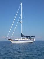
| Vessel Name: | Kolibrie |
| Vessel Make/Model: | Bayfield 36 |
| Hailing Port: | Jackson |
| Crew: | Wayne & Pat |
| About: | Back in Michigan for Hurricane Season 2009... |
| Extra: | Our boat is a Bayfield 36. Not the fastest little thing, but a nice little cruiser that we like to call home. |
| Home Page: | www.kolibrie.us |
Gallery not available
Great Lakes to The Bahamas
Who: Wayne & Pat
Port: Jackson