Sailing Leander
Sailing Leander
Who: Sima Baran & Paul Robertson
Port: Boston
Favorites
22 November 2010 | Fethiye, Turkey
22 October 2010
20 July 2010 | Endeavor Bay, Tawila Island, Egypt
17 July 2010 | Red Sea, Egypt
15 July 2010 | 27 41 N, 33 48 E
14 June 2010 | 14 48 N, 42 57 E
12 June 2010
08 June 2010 | Sataya (Dolphin) Reef, Red Sea, off the coast of Egypt
07 June 2010 | Dangerous Reef, Foul Bay, Egypt
02 June 2010 | Khor el Morob, Sudan
30 May 2010 | Marsa Shin'Ab, Sudan
27 May 2010 | Marsa Shin'ab, Sudan
25 May 2010 | Suakin, Sudan
24 May 2010 | Aden, Yemen
03 May 2010 | Day 5: 160 miles northeast of Aden, 15 miles from the Yemeni Coast
29 April 2010 | Day 1: Passage to Yemen
24 April 2010 | Day 16: 135 Miles From Salalah, Oman
21 April 2010 | Day 13: 460 Miles From Salalah, Oman
19 April 2010 | Day 11: A Little Bit Closer to Oman
18 April 2010 | In the midst of the Arabian Sea
Day from Purgatory
12 November 2007 | Chincoteague Inlet, VA
Paul

Leaving Ocean City and heading south, there are only two possible stops along the way, both equally dangerous and undesirable. Curly and his fellows in the marina office heavily endorsed Chincoteague Inlet over Wachapreague Inlet and given that the wind was to blow on our nose all day, we decided that we would go to Chincoteague at the end of the day and cut our misery short.
Having the wind on our nose is a really uncomfortable way to be in our boat. I know it sounds pretty common sensical to not want to be driving into the wind, but it is really really nasty. The boat fights through the waves while the wind tries its mightiest to keep you from proceeding. In and out of the waves we go and with each passing moment we get more and more uncomfortable. Sima's proclivity to get seasick easily does not help matters at all. Around hour two of our day, she was feeling nasty and could not do much other than lay in the cockpit and sleep. Getting up was ok, until she did anything that involved reading or concentrating, after which she'd feel terrible again.
After bobbing up and down all day we reached the first sea buoy marking our turn into Chincoteague as the sun was getting lower in the sky. But this entry was even more challenging than the night before, because they had recently moved all the buoys after Tropical Storm Noel remade the area. The buoys far out to sea were where they should be, and those in the inner part of the inlet were too, but in between the shoals had shifted, and we wouldn't know how so until we came to them.
(Unlike NE, where there are big harbors with lots of bobbing sailboats from town to town, the coast down here is somewhat less inviting. The shore presents miles and miles of sandy beach on outer islands, broken every 40 miles or so with inlets that allow access into the inner barrier, which typically consist of shoals, dunes, and breakers. So you point your boat at where the chart says it will open up and swallow you with rolling you over in the sand, and you trust.
Talk about surfing. My heart was in my throat the whole way in today. We rode one big wave in particular for a full thirty seconds. Think of a 13 ton surfboard. And as the wave finally passes, the boat gets pitched this way and that, so trying to stay on course is a challenge. And as you're watching the map on the c hart plotter, and the buoys, you're also watching the depth. We had 7 feet beneath the keel at one point, riding one of the waves. That's not so much.
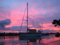
Most of the buoys were lighted, which helped as dusk started to fall. Sima was at the bow, spotting for the markers. At one point, we saw a red buoy marking the right-side of the channel, thirty yards in front of us, and another two hundred yards away. We were about to steer that course, when we noticed a couple of things. First, waves were washing onto a shoal between the two! Second, we saw a green buoy marking the left-side of the channel 90 degrees to our right, before the other red, although in back of that were more breakers. No choice but to obey the lights. So we swung a hard right. More buoys appeared, and we followed between them, zigzagging between the shoals. The chart plotter came in handy again, as these buoys were starting to be where they were supposed to be. The surf started to die down as it was deadened by the various shoals we were going around, and we finally found a suitable anchorage back among the estuaries. And here we sit, in 16 feet of water, bobbing comfortably after a pretty intense day. Off in the distance the surf still rumbles.
Having the wind on our nose is a really uncomfortable way to be in our boat. I know it sounds pretty common sensical to not want to be driving into the wind, but it is really really nasty. The boat fights through the waves while the wind tries its mightiest to keep you from proceeding. In and out of the waves we go and with each passing moment we get more and more uncomfortable. Sima's proclivity to get seasick easily does not help matters at all. Around hour two of our day, she was feeling nasty and could not do much other than lay in the cockpit and sleep. Getting up was ok, until she did anything that involved reading or concentrating, after which she'd feel terrible again.
After bobbing up and down all day we reached the first sea buoy marking our turn into Chincoteague as the sun was getting lower in the sky. But this entry was even more challenging than the night before, because they had recently moved all the buoys after Tropical Storm Noel remade the area. The buoys far out to sea were where they should be, and those in the inner part of the inlet were too, but in between the shoals had shifted, and we wouldn't know how so until we came to them.
(Unlike NE, where there are big harbors with lots of bobbing sailboats from town to town, the coast down here is somewhat less inviting. The shore presents miles and miles of sandy beach on outer islands, broken every 40 miles or so with inlets that allow access into the inner barrier, which typically consist of shoals, dunes, and breakers. So you point your boat at where the chart says it will open up and swallow you with rolling you over in the sand, and you trust.
Talk about surfing. My heart was in my throat the whole way in today. We rode one big wave in particular for a full thirty seconds. Think of a 13 ton surfboard. And as the wave finally passes, the boat gets pitched this way and that, so trying to stay on course is a challenge. And as you're watching the map on the c hart plotter, and the buoys, you're also watching the depth. We had 7 feet beneath the keel at one point, riding one of the waves. That's not so much.
Most of the buoys were lighted, which helped as dusk started to fall. Sima was at the bow, spotting for the markers. At one point, we saw a red buoy marking the right-side of the channel, thirty yards in front of us, and another two hundred yards away. We were about to steer that course, when we noticed a couple of things. First, waves were washing onto a shoal between the two! Second, we saw a green buoy marking the left-side of the channel 90 degrees to our right, before the other red, although in back of that were more breakers. No choice but to obey the lights. So we swung a hard right. More buoys appeared, and we followed between them, zigzagging between the shoals. The chart plotter came in handy again, as these buoys were starting to be where they were supposed to be. The surf started to die down as it was deadened by the various shoals we were going around, and we finally found a suitable anchorage back among the estuaries. And here we sit, in 16 feet of water, bobbing comfortably after a pretty intense day. Off in the distance the surf still rumbles.
Comments
| Vessel Name: | Leander |
| Vessel Make/Model: | Bristol 41.1 |
| Hailing Port: | Boston |
| Crew: | Sima Baran & Paul Robertson |
| About: | Following our wedding in Istanbul we are taking a two-year break from land-life and going sailing. Sima is taking time off between strategy consulting and business school while Paul is on a sabbatical from his career as an attorney. |
Gallery not available
Sailing Leander
Who: Sima Baran & Paul Robertson
Port: Boston