Closeup of the GPS Chartplotter Depthfinder During a Passage
25 September 2007
• Sea of Cortez
by Keith - May 2007
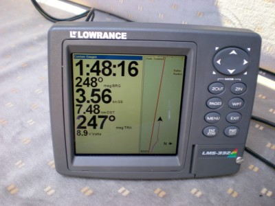
On the right you can see the red line indicating the ideal straight line course to the GPS position I previously entered into the system. The arrow represents my current position and the line behind it is where I've been. I should be following the straight red line but the wind this day is only good if I sail to the west of my destination. As I turn towards my destination, I'm sailing more into the wind and probably required engine power. I think the top number is the time of day, 248 is the direction the computer has calculated I need to be traveling in order to reach my destination (bearing), 3.56 is my speed in knots (about 4 mph - fairly reasonable cruising speed for Singmeaway), 7.48 is the distance in knots to my destination (bit over 8 miles), 247 is the direction I am traveling. It is telling me I need to go just a wee bit more left to optimize track but one degree from optimum bearing with 7.5 knots to go is essentially right on track and when those two numbers are very close, I am on course. This incredible machine does a lot more than this, but you can see how this technology has absolutely revolutionized ocean cruising. There isn't a sextant on my boat and I wouldn't know how to use one anyway. Just a back-up GPS. Getting lost is pretty much impossible with a functioning GPS and a map.

Comments