Thistle
Sailing Thistle South

04 November 2016 | Norfolk, VA
03 November 2016 | Back Creek, Annapolis, MD
01 November 2016
31 October 2016
28 October 2016
28 October 2016
27 October 2016
27 October 2016
23 October 2016
22 October 2016
20 October 2016
16 October 2016
16 October 2016
08 October 2016
29 October 2012
26 October 2012 | Great Bridge
25 October 2012 | Great Bridge
23 October 2012 | Deltaville
22 October 2012 | Mills Creek, Solomons MD
21 October 2012 | Whitehall Creek
Homeward Bound
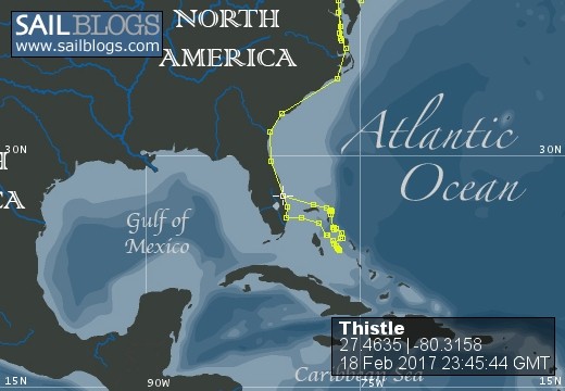
18 February 2017 | Fort Pierce, FL
Grinnell / Breezy & Warm

Thistle at Great Sale Cay
It would have been nice to rest at Great Sale Cay before pressing on but we were riding a clocking front and needed to be out of the Gulf Stream before the wind went west and then north. So our stop at this sliver of land consisted of taking Chloe to shore, investigating the stranded ketch, clicking the sunset photo, and getting under sail again within 45 minutes.
We headed into the darkness, slightly north of west, across the last 50 miles of the Little Bahama Bank and then into the deeper waters that separate the Bahamas and Florida. We set the autopilot and then also set alarms in case we both fell asleep. Shortly after entering the Gulf Stream Linda noticed a ship's lights to starboard. We pulled it up on radar and AIS. The 1000 foot, 80,000 ton Maersk Kokura was about 6 miles away, travelling at 18 knots, and on a perfect collision course. It's best to get these kinds of situations sorted out ahead of time so we hailed them on the VHF radio.
"Maersk Kokura, Maersk Kokura, Thistle".
Pause.
"This is Maersk Kokura".
"Maersk Kokura, we are the sailboat 6 miles off your port bow. I believe we are on a collision course and want to make sure you know we are here".
Long pause.
"Thistle, we are changing course 10 degrees port".
Long pause.
"Maersk Kokura, I see your course change -- thank you very much!".
About 26 hours and 175 miles after leaving Green Turtle Cay we entered the inlet at Fort Pierce, Florida. We motored past the Coast Guard station, somehow avoided being pulled over for a random boater safety inspection, dropped the hook beside the channel, hoisted the quarentine flag, and started the process of cultural reacclimation.
Great Sale Cay
17 February 2017
Grinnell / Clear & Warm
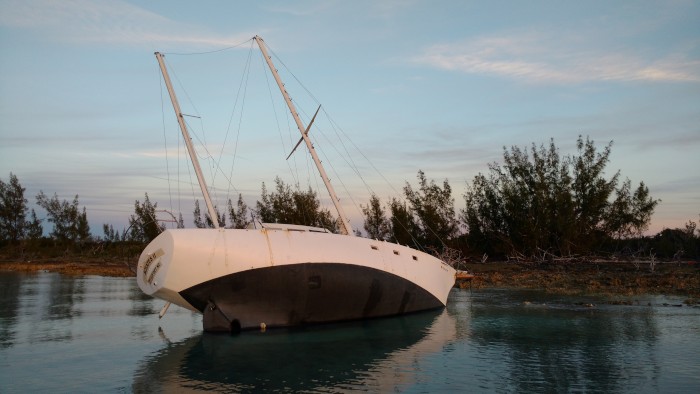
Stranded ketch at Great Sale Cay
With family events planned for early March in Florida we'd been looking for a weather window to recross the gulf stream. We departed Green Turtle Cay on a rising morning tide and fetched desolate Great Sale Cay at sunset. We'd planned a brief land stop for Chloe here before sailing on through the night.
We lowered the dinghy and went ashore near a shipwrecked ketch, masts still standing, sails on, hull seemingly intact. We'd heard about this boat back at Man-O-War. She had gotten caught as a front clocked around, dragged anchor, and was pushed by wave and tide into the limestone shallows. Her cockpit and cabin were in shambles, her engine half submerged.
Her owners had written in black marker on her cabin: "Please don't take anything, we're coming back for her". Both of her booms had dropped off her canted decks and into the water. I resecured them in what was probably a futile gesture. Salvage costs will easily exceed the value of this boat. If they do come back it will be an act of devotion.
Green Turtle Cay
15 February 2017 | Green Turtle Cay
Grinnell / Windy
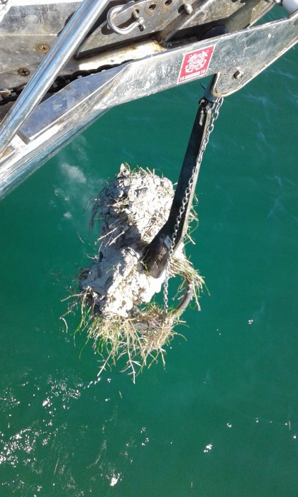
Turtle grass clogging our Rocna anchor at Green Turtle Cay
We arrived at Green Turtle near low tide and would have run aground if we'd tried to enter. Yup, the Abacos are shallow. So we dropped the hook in 8 feet of water outside the entrance and went in on the next morning's high tide. White Sound Harbor has a reputation for poor holding so we put out plenty of scope, let the hook bite, and backed her down after a while. Good to go, we thought.
As the wind rose into the low 20s several neighbors started dragging -- not normal! And they all had roll bar type anchors like ours -- not good! Never had we seen this type of mass failure. What's going on down there? A dive on our own anchor answered the question and an anchor drill ensued. In the end we rode out the blow on two anchors, which was a first for us. But it made the prep work and inconvenience of having kept the big storm Danforth rigged on deck throughout the Bahamas worth it in the end.
It was Valentine's day and with the anchors holding we had dinner that night on shore listening to the mellow tones of "The Sax Man" as he and his smooth talking front man worked through their repertoire of 80's and 90's romance hits. It was corny but it was sweet and three weeks later the melodies are still dancing in our heads.
Sailing an Inland Sea
15 February 2017 | Green Turtle Cay, Abacos, Bahamas
Grinnell / Windy
The evening scene at Hope Town Inn & Marina
Glancing at a small scale chart one could overlook the string of cays and reefs that break the seas before they reach the larger Abacos. This rocky band lies just a few miles from the bigger islands and the gap between them forms an inland sea. We'd entered this navigable, lake-like waterway at Little Harbor Cut and now stretching before us to the north and west was the promise of 80 miles of smooth sailing. With a front forecast two days out we sailed at a leisurely pace from Lynyard Cay through shimmering waters toward Elbow Cay.
We'd reserved a slip in Hope Town Harbor but the tide was low and the entrance shallow. So at Matt Lowe's Cay we turned west instead of east and passed the afternoon anchored in Marsh Harbor. Late that afternoon we motored eight miles east again to Elbow Cay and cleared the crooked harbor entrance with the help of a rising moon tide. As we threaded our way through the tightly packed boats new friends we'd met at Lynyard Cay dinghied over to help orient us and catch our lines. That evening Thistle lay calmly under the glow of restaurant lights and beneath the gaze of Hope Town's antique kerosene lighthouse as the full moon shone down through gaps in the gathering clouds. The next days, as the winds blew from the north, we explored the island's beaches, cart paths, and dollhouse-like settlement village.
In the wake of the front, again timed for high-water, we traipsed north a few miles to the well protected and serene harbor at Man-O-Way Cay. Though Man-O-War and Hope Town have very different feels we were struck by the friendliness of everyone we met, cruisers and locals alike. We made more new boat friends at Man-O-War, did further exploring, and then pushed on again to catch a weather window past feared Whale Cay. "The Whale", as it's known, abuts a shallow sand bank which forces most boats to traverse its eastern ocean side. A stiff north or east wind renders the passage dangerous and sees boats stacking up on both sides waiting for conditions to moderate.
Our wind was from the northwest, putting The Whale in a pleasant mood. We beat our way past, ducked inside again at Whale Cay Cut, and made our way into another enticing harbor at Green Turtle Cay. The winds were clocking and we needed safe harbor for yet another 30 knot frontal passage. Green Turtle's White Sound harbor seemed just the place.
Offshore to the Abacos
07 February 2017 | Lynyard Cay, Abacos
Grinnell / Warm & Clouds
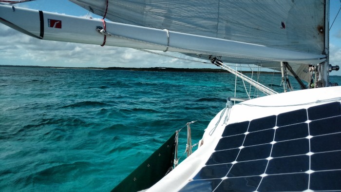
The opaline shallow sea inside the reefs at Little Harbour Cut
We scoped out and rejected three anchorages off Egg Island before backtracking a couple miles to anchor off a failed resort on the southern side of Royal Island. "Resorts" that don't match the name seem to be a feature of the Bahamas. Perhaps the brainchildren of over enthusiastic developers, or investment scams, or casualties of changing travel trends, or simply fodder for well aimed hurricanes, these mistakes waste money, junk up the landscape, and generally complicate the cruiser's life. So it was at Royal. The club house and fitness buildings look in good repair as do the 5 deserted beach villas. But where are the people?
Oh, there's one - some type of security presence? Just enough to discourage me from landing on this otherwise deserted and attractive beach -- another slice of paradise revoked. So I did my Navy Seal routine: wait till dark, counter surveil through the binocs, row ashore with no engine, and slip in behind the breakwater. Hey, there's a shallow patch of sand here outside the ironshore at low tide. Anchors down -- come on Chloe -- were going ashore! Another successful mission and they'll never know we were here...
We infiltrated again at 5:30. Then we upped hook at first light and rounded Egg Island onto a due north course across 50 miles of open Atlantic. Clear of Egg we felt the swell rolling down from the northeast. The sailing was a 16 knot beam reach and Thistle rose, fell, and yawed around as wind driven waves reinforced the swell.
Miles before landfall the undersides of the clouds started glowing green with the reflected glimmer of the Abaco banks. The chart for Little Harbour Cut has the notation "BREAKS ACROSS IN LARGE SWELLS". Warnings like that command attention. Fortunately, our definition of large swells matched the cartographer's. The moderate swell was breaking on the bordering reefs only and nicely framed the navigable cut.
A couple more miles saw us anchored behind long skinny Lynyard Cay listening to the pounding surf across a tropical meadow and outer beach beyond. Another slice of unimproved paradise beckoned.
The Top of Eleuthera
06 February 2017 | Royal Island, Eleuthera
Grinnell / Warm & Clear
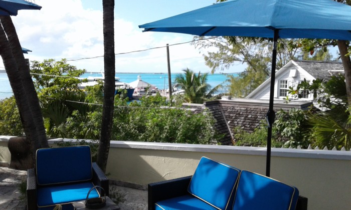
View from The Rock House, Harbour Island
There are two principal islands of note at the top of Eleuthera: Spanish Wells to the west and Harbour Island to the east. We visited both. To get to Spanish Wells you go through Current Cut, which can be rough if timed wrong. Navigating on to Harbour Island is altogether more intimidating. A six mile course named "The Devil's Backbone" (cheery, eh?) threads over shoals, through breaking coral heads, almost up onto a wild and deserted beach, around more coral heads, and then through the shallows into the natural harbor between Eleuthera and the appropriately named Harbour Island.
The seas being a bit rough (did I fail to mention the route is open to the Atlantic?) with a hefty swell rolling in we opted to save the fee for the strongly advised local pilot and instead enjoy a smoother ride on the high-speed twin-hulled ferry. Four big Cummins turbo diesels can push the hefty aluminum cat at probably better than 25 knots but the swell kept her throttled back through the rougher sections. I ran from side to side clicking away with the camera to create a visual record, for the next time we're down this way, and if the swell is down...
Spanish Wells and Harbour Island are both loyalist settlements. This is generally evidenced in more abundant displays of English tastes and mores. Harbour is quaint with an old New England village feel. With bountiful reefs and sun-soaked beaches supporting several resorts the industry is largly tourism. Spanish Wells, by contrast, is a fishing town. One that's doing pretty well by the looks of the place.
The top of Eleuthera offers more than interesting cultural contrasts -- it also positions one for the passage to the Abacos. Our last night in Eleuthera was spent anchored off Royal Island where we readied Thistle for departure at first light.
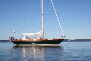
| Vessel Name: | Thistle |
| Vessel Make/Model: | Lyman Morse Seguin 46 |
| Hailing Port: | Portsmouth, NH |
| Crew: | Grinnell and Linda and Chloe {Welsh Corgi} |
| Social: |
|
Thistle's Photos - Main
No items in this gallery.
Profile for Thistle
Who: Grinnell and Linda and Chloe {Welsh Corgi}
Port: Portsmouth, NH