Rainy Season is Here
11 June 2022
• Shelter Bay Marina, Colon, Panama
by robin
As soon as we slowed the pace of our morning jungle walk it became evident rainy season in Panama is upon us. We had not seen many bugs to now our limbs were instantly attacked by mosquitos. It had rained last night and the clouds looked like they were going to pour already. No bug-eyed red frogs for us but a quick dash back to the boat for blueberry pancakes. We are not sure where the blueberries came from. Karl said Dole which probably means a container ship from somewhere far away arrived in Panama filled with frozen blueberries.
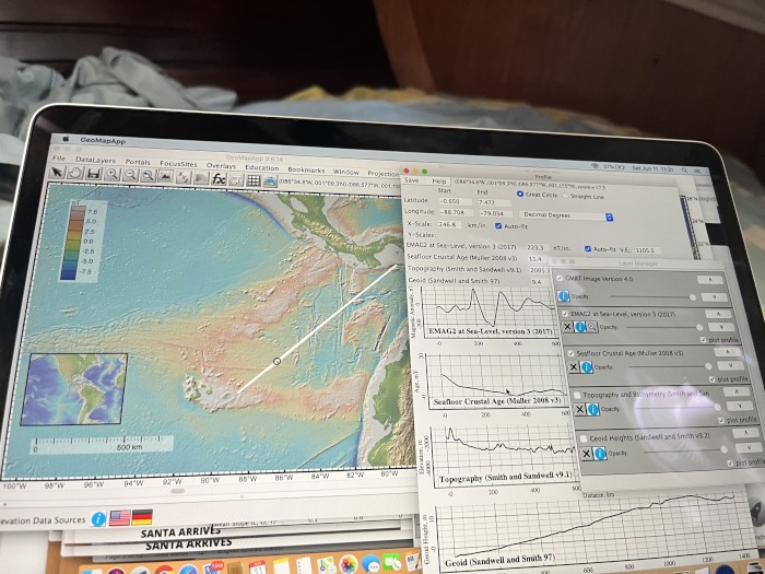
I spend much of the morning whining about the possibility we will have to pay to get out hourly positions for the trip. Our iridium phone is programed send a position every hour to a website so our family knows where we are, how fast we are going and what the winds are going to be in the next few days. It is a big change from the daily update with the ham radio operators who mostly got the positions right. Only once did they post our position in Uzbekistan. We also write down our position in the ship’s log every hour along with course speed, conditions such as wind, waves, visibility, cloud cover, pressure and temperature. The Mabel Rose has 4 GPS systems running all the time. My job for the past 35 years has been recording GPS data to position aircraft and ship to within 10cm or so. To find we have to pay to get back our data is so creepy. Despite my complaining, I am not keen to type in all those numbers. We have been sailing about 20 days so a position is 4 numbers in degrees and decimal minutes (for example each hour 12 45.2N and -72 35.3w). So, each day has 80 numbers and hourly positions add up to almost 2000 numbers. I hate buying back my own data. We will turn on track mode in one of the onboard GPS so we can download it directly rather than coughing up 40 cents per number and paying someone in New Zealand to run a script to recover our data. Once I have our positions, I can use one of Lamont’s free marine data tools – Geomapap to explore what to crossed over. This free program is a way to see below of ocean’s surface. You can plot how deep the ocean is, how old the ocean floor is and even the gravity and magnetics. No snarky email was sent to the company. Calmer head prevailed– just a faux text from Karl pointing his geophysicist wife is not pleased to pay for her data.
The day passed quickly working through that long post-it to do list. Ranging from plotting how old the ocean crust we have sailed over and how old it will be in the next leg. Really young and some just being born. The Galapagos sit on the equator so having an equator crossing ceremony will not break up the next passage much. I have announced we should have a crossing the mid ocean ridge the place where new ocean floor is being produced should be our celebration.
As it poured this afternoon, I developed a Covid Plan for the Galapagos authorities. My friend Sean, in charge of Lamont’s ship was really helpful in developing the plan. Lamont’s ship, the Langseth, is surveying off the coast of Mexico right now. Anne the lead scientist is working to image the ocean floor to understand how the big earthquakes in Mexico happen. Sean’s job of getting the 43 or so people safely on board required a lot of work on these Covid time. His guidelines were a useful framing for our Covid plan. I also used the WHO plans for fishing vessels and cargo ships plus a little from CDC. We continue to wear masks inside public spaces all the time as we are always close to going offshore and cannot chance getting Covid. Karl the master and Robin the Chief Medical Officer signed out Covid Plan. It needed to be stamped. I was disappointed we did not have the marine life stamps I shared at Christmas. Karl did not think the authorities would appreciate star fish and shark stamps. Karl found the formal Mabel Rose stamp and the document was done.
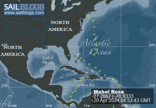
As I type two of the French boats with children, Ohana and Dreamcatcher, have just slipped out of the first three locks into the large lake – Lake Gatun - where they will spend the night. The children, their parents, the pilot/advisor 1-3 line handlers and their boats went through tied up behind a large (182m long) Singapore flagged chemical tanker. We have been listening to two families progress all day with the chatter on the Port Control channel. The port control woman on the radio is definitely in charge of this dance floor. Any ship not doing exactly what she orders, hears quickly and sternly from her. She takes no excuses. Our French friends left the anchorage later than planned. The advisors/pilots might have been waiting for the torrential rain to stop. Marine traffic is both a web site and an ap where you can watch ships around the globe move. We watched Ohana and Dreamcatcher pass through the locks. Now they are looking for the large mooring buoy in the lake where they will tie up for the night before continuing on. In 24 hours, we will be the ones in the lock then looking for the mooring buoy to tie up to for the night. It will be possible to track us on Marine Traffic either the ap or the website.

Comments