A Cross Ocean Experience
Seven thousand miles of outstanding cruising since November 2008 means it's time to do a little renovation and more planning for the future. Find out what ...
20 February 2013 | Fishtail, Montana, USA
26 May 2012
15 March 2011 | Swallow Falls State Park, Garrett County, MD
07 January 2011 | Deep Creek, MD
01 January 2011 | Tacoma, WA
28 December 2010
17 December 2010 | Sierra Madre, CA
12 December 2010 | Leucadia, CA
12 December 2010 | Leucadia, Ca
12 December 2010 | Ramona, CA
06 December 2010 | Ramona, CA
06 December 2010 | Ramona, CA
20 November 2010 | New Orleans, LA
13 November 2010 | Lexington, KY
09 November 2010 | Louiville, KY
05 November 2010 | Lexington. KY
01 November 2010 | Deltaville, VA
29 October 2010 | Deltaville, VA
22 October 2010 | Deltaville, VA
08 October 2010 | Deltaville, VA
Bahia Santa MAria and visions of Cortez
14 December 2008 | Bahia Santa Maria
Richard Cross

There's room for a navy to swing here, and looking across the vast expanse of empty bay it is impossible not to envisage just that scene, as it would have been in the early 1500's when Cortez explored this coast and shortly thereafter when pirates laid in wait to ambush Spanish ships laden with gold, returning from Manila. The image is easy to conjure since the bay can have changed hardly at all. The entrance, bordered by raw ochre mountains is eleven miles wide, opening into an elongated C shape, fringed with low sand covered dunes. There is one fishing camp of a few huts and pangas, but almost nothing else to denote man's presence. For most of our time here we have been alone or in the company of one other boat. Bahia Santa Maria is a lonely, windswept place.
It is hard to grasp the scale of Baja, but traveling at four miles an hour helps. A bay four miles deep takes an hour to enter. Formerly known simply as California, it only acquired the suffix Baja (Lower) when its newer more prosperous neighbor to the north lost its (Alta). As Joseph Wood Krutch so elegantly states in his wonderful book "The Forgotten Peninsula", "Baja came into Western history long before the New England coast, but has stayed out of it pretty persistently ever since."
Developer has followed priest, who followed soldier, but with the notable exception of the festering carbuncle that is Cabo San Lucas, all have failed within a remarkably short time. It is perhaps because as Father Wenceslaus Link, one of the last missionaries to write of Baja, described it "there is here nothing but rocks, cliffs, declivitous mountains and measureless sandy wastes, broken only by impossible granite walls." All intimidating for the under- supplied seventeenth century padre, but invigorating and awe inspiring for the privileged twenty-first century vagabond traveler.
The peninsula is roughly twice as long as Florida, yet on the Pacific side there is no town of more than several hundred between Ensenada and the Cape, a distance of more than 700 miles.
We have so far gained 8 degrees of Southing (for the landlubbers, each minute of latitude equates to one nautical mile, therefore a degree is 60 nautical miles) and will, in the next few days, cross the Tropic of Cancer before arriving in Cabo San Lucas, where we plan to stop only for rest. There we will have the choice of turning north into the Gulf of California (Sea of Cortez) or continuing south-east to the Mexican mainland around San Blas.
We have chartered in the Gulf four times and have loved every minute of it, but December to February is the cold season there and we are drawn by the warmth of the tropics and will probably continue south. Tentatively we plan to be in San Blas, Nayarit for Christmas and then we will see which way the wind blows.
Comments
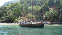
| Vessel Name: | Mandy |
| Vessel Make/Model: | Bristol Channel Cutter 28 - http://www.capegeorgecutters.com/BCC28/index.html |
| Hailing Port: | San Diego, CA USA |
| Crew: | Richard & Virginia Cross |
| About: |
Gallery not available
There Goes Mandy!
Who: Richard & Virginia Cross
Port: San Diego, CA USA
Also look here:
- Gallery of Mandy - pre Nov. '08
- Gallery of side trips
- Gallery of Mandy Minor
- Videos
- Log Recap
- Gallery of Galicia
- Top man in Galicia - Mark Adkinson
- BCC Owners Forum
- Cruising World Magazine
- Living Aboard Magazine
- Ben Eriksen's BCC
- Dave & Kathy - Lightspeed
- Great Recipes
- Heart Hustle Collective
- Jan & Yolanda Palmboom
- Or The Whale - Fav.Music
- Shoal Bay Lodge - Vancouver Island
SailBlogs Friends

