
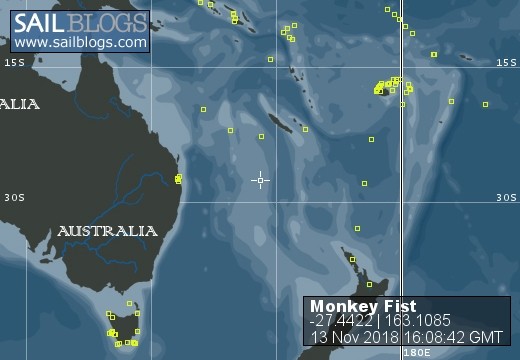
Monkey Fist
Who: Paul and Frances Tudor-Stack
Port: Darwin
Favorites
- Eyeglass Assist - Solomon Island Project
- OnTheNose
- PKA Products
- Lions Recycle For Sight
- Monkey Fist movie - Mexico to the Marquesas
- How to tie a Monkey's Fist
- Death in Paradise
- Raramuri
- Cruisers Comfort
- Diablo Canyon Nuclear Power Plant
- Fords Terror Time Lapse
- Galloping Gertie
- Gotz Guitar website
- Hawthorne Gallery
- Monkey Fist in Johnstone Strait
- Monkey Fist sailing in New Zealand
- Oki Islands, Japan - information
- Princess Louisa Inlet
- The Chichi Jima Incident
- Tsunami wave hits Brookings
13 November 2018 | Brisbane, Australia
04 November 2018 | On Passage - The Coral Sea, 480 MTG, 650 miles logged
28 October 2018 | Honiara, Solomon Islands
21 October 2018 | Shortland Islands, Western Province, Solomon Islands
18 October 2018 | Bay of 1,000 Voices, Choiseul., Solomon Islands
18 October 2018 | Bay of 1,000 Voices, Choiseul., Solomon Islands
15 October 2018 | Bay of 1,000 Voices, Choiseul, Solomon Islands
14 October 2018 | Pelau, Ontong Java, Malaita Province, Solomon Islands
14 October 2018 | Luaniua, Ontong Java, Malaita Province, Solomon Islands
14 October 2018 | Ontong Java Atoll, Malaita Province, Solomon Islands
03 October 2018 | Choiseul, Solomon Islands
02 October 2018
02 October 2018
02 October 2018
27 September 2018
27 September 2018
27 September 2018
27 September 2018
24 September 2018
24 September 2018
Four minute in the Tuamotus
21 July 2017 | The Tuamotus archipelago, French Polynesia
We have been to the Tuomotus before, in 2013, so we knew what to expect. But I have to say that we had forgotten how stunningly beautiful these atolls really are. I guess more than anything for us, it is the colours. Perfect white sand beaches, coconut palms waving in the balmy tropical breezes but, above all the hues of iridescent blue shimmering beneath a pane of rippled glass. When it's overcast it is still stunning but when the sun is brilliant in the blue sky it is mind blowing. The in-water visibility is generally a subjective value but I would estimate we have seen up to 40 metres, which is difficult to better. Because there are no rivers here there is nothing to dump sediment into the water which accounts for much of the clarity.
We made landfall at Takaroa, 450 miles south west of the Marquesas, after what started out as a fast passage, the first 28 hours we made 220 miles, but the beam wind faded for a while and later picked up again. We didn't quite make it to Takaroa in the daylight so we anchored outside the pass, which was a more than suitable anchorage in the lee of the island so we spent the next 3 nights there rather than go into the lagoon. We were lucky enough to meet a teacher who spoke English and he filled us in about the now defunct pearling industry there and gave us the password to the council wifi to check our emails so we gave him a big bunch of bananas that he shared with his fellow workers at the council - banana crepes were on the menu.
The airport was just out of the main village and nestled between the open ocean and the lagoon. Right where the terminal was was a small man-made dock and quay and this would have been a fantastic place to fly into and be ferried out to a waiting yacht anchored in the turquoise lagoon. The stuff of dreams.
On leaving Takaroa we had to sail the 65 miles to the next atoll, Aratika, overnight in order to be at the entrance of the pass by 7 am at which time we expected slack water to be. Determining when slack water is at a pass at any atoll in the Tuamotos is a black art. There are so many influences that preclude long term prediction of current flow that it is pointless to do so. The Pilot for the area, the official guide, relates current flow to specific times before and after moon set and moon rise; other information relates the current flow to the sun and yet another influence, which many believe is the most influential is the height of the waves crashing onto the surrounding reef and washing into the lagoon. This is the only explanation for the fact that, the vast majority of the time, the current flows out of the lagoons. Of course this all makes it difficult to predict when slack water is going to be and every atoll is affected differently.
I must say that I was a little reluctant to tackle an east facing pass due to the added complication of having waves and swell confronting the strong currents at the pass. But the pass was a reasonable depth and only short and by the time we arrive the wind had died to only a light breeze so it was worth a look. The current was still pouring out of the narrow pass and causing standing waves (mixed with swell) 100 metres from the pass. What we have done in the past is try and avoid the standing waves by approaching from the side and then maneuvering into the centre of the pass upstream of the standing waves. The only real unknown and only real danger is how strong the outflowing current is. Once you are in the main flow, before you enter the pass itself and therefore commit your boat to transitting, it is possible to gauge pretty well how strong the current is. I prefer an opposing current as this allows for slower speed and more control, of course this is a fine strategy but is based upon one important assumption : that the current is not greater than the maximum forward speed of your boat. Even if this was the case this would not be necessarily disastrous as it's theoretically possible to steer under these conditions while exiting a pass sliding backwards but it's not a position I wished to put ourselves in. Any turbulence could be catastrophic.
We moved in close to the pass, had a good luck and decided to wait. A hour later we did the same thing again and again we decided to give it more time. I should also say that there is a pass on the sheltered western side of the atoll but all the information we had at that stage told us that it was not deep enough for us to enter (which we later found was totally inaccurate). If we decided the east pass was too dangerous plan B was to sail the 13 miles to the west pass, anchor outside and survey the depth ourselves in our dingy. However, on the 3rd time that we checked out the pass I decided that conditions had improved enough to enter (the current had slackened off a little). It was nail biting stuff as the entrance was only narrow nor is it straight but as we slowly edged towards the narrow gut Monkey Fist still had plenty of speed left in her. In the end the current was flowing out at just under 5 knots so we were able to make 2 knots of headway. Sure the engine could have failed but as we hadn't had any issues with her since San Francisco, 10 months previously, if it did malfunction then it was fate.
We successfully entered the pass and the lagoon itself was clear and tranquil and we spent the next 3 days enjoying the beauty and peace of this semi isolation. We met a few of the local people who were very friendly needless to say. We spoke about the east pass and it did indeed have a reputation for being dangerous. We were told that only 3 years previously a New Zealand yacht had been wrecked trying to enter via the pass. We would not be exiting the atoll the same way.
Still having a significant number of bananas from the Marquesas we gave them to two families we had spoken to earlier in the day. They don't grow bananas here and it was the first time in 5 years that one lady had eaten bananas so they were a real treat.
After leaving Aratika we planned to head to Kahuei but the wind was against us and so we turned our bows towards Fakarava, the same distance but at a much better angle. The very wide north pass at Fakarava had a outflowing current of over 5 knots so, although it was quite safe we were often down to less than 2 knots over the ground. Once in we waited at Rotova in the north western corner of the atoll until the northerly wind started veering around to the south. The south pass of Fakarava was our goal and to experience the world renowned dive with sharks.
So to cut a long story short.... I've added a video to Youtube which runs for 4 minutes that will hopefully give you an idea of how beautiful this archipelago is.
Comments
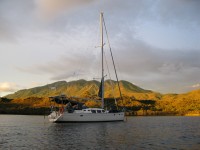
| Vessel Name: | Monkey Fist |
| Vessel Make/Model: | Jeanneau 43DS |
| Hailing Port: | Darwin |
| Crew: | Paul and Frances Tudor-Stack |
| About: | After spending over 20 years in the NT Paul and Frances returned to the sea in 2008. Their first trip was into the Pacific via West Papua and over the top of PNG and then back to Australia where they sold their old traditional boat "Sea Spray" and bought "Monkey Fist" |
| Social: |
|
Monkey Fist's Photos - Main
No items in this gallery.
Monkey Fist
Who: Paul and Frances Tudor-Stack
Port: Darwin
Favorites
- Eyeglass Assist - Solomon Island Project
- OnTheNose
- PKA Products
- Lions Recycle For Sight
- Monkey Fist movie - Mexico to the Marquesas
- How to tie a Monkey's Fist
- Death in Paradise
- Raramuri
- Cruisers Comfort
- Diablo Canyon Nuclear Power Plant
- Fords Terror Time Lapse
- Galloping Gertie
- Gotz Guitar website
- Hawthorne Gallery
- Monkey Fist in Johnstone Strait
- Monkey Fist sailing in New Zealand
- Oki Islands, Japan - information
- Princess Louisa Inlet
- The Chichi Jima Incident
- Tsunami wave hits Brookings