
Peter, Heloisa and Auke cruising Westwards around the globe with s/v Mundinho
Our position is updated regularly. Click on Current Position (right side) to find out where we are.
18 December 2012 | Shelter Bay Panama
28 November 2012
19 August 2012 | Panama city BYC
14 August 2012 | 7 34.734'N:78 11.947'W, Bahia Pina, Panama
04 August 2012 | 1 48.992'N:78 43.717'W, Tumaco - Colombia
29 July 2012 | 8 24.0264'N:79 04.9178'W, Isla Pedro Gonzalez - Archipel Las Perlas
23 July 2012 | Panama city
21 July 2012 | Colon, Panama
17 July 2012 | Colon, Panama
10 July 2012 | 9 35.228'N:78 52.950'W, Chichime
29 June 2012 | 9 35.346'N:78 40.542'W, Kalugir Tupu and Banedup
26 June 2012 | 9 35.191'N:78 44.751'W, Miriadiadup
24 June 2012 | 9 35.231'N:78 52.839'W, Uchutupu Pippi
21 June 2012 | 9 32.722'N:78 53.754'W, Cay Limon
15 June 2012 | Colon Panama
13 June 2012 | Shelter BAy, Colon Panama
11 June 2012
08 June 2012
06 June 2012 | Shelter Bay, Colon Panama
04 June 2012 | Shelter Bay, Colon Panama
Shore side Communication on board
03 February 2012 | George Town,Exumas Bahamas
Peter via Internet
Many cruisers I have met asked us about our satellite phone set up and how we get email and grib files. There is apparently still quite some level of unawareness amongst cruisers on how you can get these weather files cost effective or a misconception that satellite phones on board an average cruising boat are cost prohibitive. However in a good set up, with a good antenna and very important good email compression software we found that the cost is very minimal and acceptable. Hence I decided to write this post, which describes our set up and how we use it.
Prior our departure we decided we wanted to have the ability to receive weather files on board in one form or the other. We also liked the idea to have something on board that ensured our family could reach us in an emergency if really required. Since Heloisa's mother is at age and not doing too well health wise, we found this comforting knowing that the home front could reach us at any time if required. Also travelling with a 7 year old to some "off the beaten track" places as we have planned, we gain comfort knowing that if we end up in a medical emergency with our son, we can access medical knowledge at any time anywhere in the world. It is all not an absolute necessity for us, however it gives us comfort.
For weather we have Navtex on board, which is a good and reliable source for weather while relative close to the coast and is a good reliable source to watch for tropical storm development. However in addition I really desired the capability to be able to download some easy to read wind charts on board that show wind direction and strengths for any upcoming three days at any time, independent the location.
The US and some European countries developed and maintain software models that predict winds around the globe or locally for their regions. The software models typically provide a basis for detailed forecasting weather around the globe. These software models can provide weather charts upon request for any selected area (grid in Lat and Lon) with a selected level of detail. The grid spacing that normally can be used is 2 degrees, 1 degree and 0.5 degrees. The files that can be requested are called Grib files (GRidded Information in Binary (GRIB) files).
Frank Singleton, a UK Met office weather man on his website http://weather.mailasail.com/Franks-Weather/Saildocs-Free-Grib-Files gives a good run-down on what grib files are. In the initial years after their commencement these software models left a lot to desire with regards to accuracy. Nowadays the major models such as the US owned and maintained GFS worldwide model I have found to be very acceptable in accuracy, certainly accurate enough for most sailing / cruising conditions in the middle latitudes and when used in addition to Navtex suitable for higher latitudes. There are some limitations such as land masses affecting the model, so you have to use the model results with caution while sailing close to the coast of major landmass. Also I have found the wind strength is often 3 to 5 knots higher in reality then predicted in the model (note in reality the sustained winds are often 3 to 5 knots higher, we are not referring to wind gusts). There is some good writing available about using grib files. Anyone using grib weather files should read up about its limitations. One often mentioned limitation with the GFS and similar model outputs is that it is not vetted by a meteorologist. You receive raw data straight from a very large computer. Written forecasts have typically been generated by meteorologist, a physical person looking over the date and drawing up a conclusion.
We have found the GFS and similar models a great weather (wind) source and I am fairly convinced many independent weather forecasters and companies providing weather forecast to individuals for a cost, draw a lot on these software models nowadays. Another limitation is the fact that the model "looks" over large areas. It does not look at small areas. A local weather burst will go unnoticed by the GSF model. We do not find that so much of an issue, as any local happening typically will not last long. I do not get overly concerned if we end up in 35 knots winds locally if it is just for a few hours. I would get concerned if it would last days, but in that case the model has typically forecasted it as the system is much larger in size and as such you would have observed it in your grib files.
Cross checking against the Navtex and VHF provided forecasts is always good and we typically do in case we do not like the forecast (we typically do not like it when "high" winds are forecasted).
The set up;
I always have a strong desire to have systems on board that are truly very simple and truly very reliable to operate. I know from my own experience that once offshore and particular in not so nice weather conditions, the first few days after departure (not having my "sea legs" yet in those first days), I am not keen on having to spend prolonged periods inside the cabin behind a chart table to get anything done. Weather files can and often are crucial for a good, efficient and safe trip, be it a short 40 miles offshore hop or a 400 Nm offshore trip, so I had myself set the requirement that to get good weather files the way should be easy and reliable at all times. ("Press of the button" type easy)
To get weather grib files (or other weather reports via email) while offshore or in areas where you do not have internet access, the typical cruiser has realistically nowadays two reliable and cost effective options to choose from (there are more options however these are either much more costly, (used in professional environments) or not having known proven reliability. The two options are either installing an SSB radio (transceiver) with Pactor modem or a Satellite phone connected to a laptop loaded with compression software.
We choose for a Satellite phone. The reason for this choice is simply I am most comfortable with the operation of this equipment, which is the same as a regular cellphone and I am comfortable with the level of reliability (virtually every time a connection when you want / need it). I have spoken to cruisers with SSB installation on board, and they have assured me that their reliability is equally high (connection every time they want / need it).
The purchase cost of a Satellite phone system is lower than a SSB installation however the operating cost is higher of the phone. For us the satellite phone with laptop set up has proven to be a most reliable and cost effective solution, capable of downloading grib weather files and regular emails (text only).
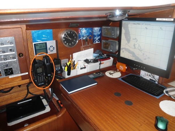
The system contains the following items;
• 1 satellite phone, Iridium.
• 1 external Iridium antenna
• 1 docking station with handset
• 1 laptop (there is no dedicated laptop. We use the same laptop we use for everything such as emails, internet, pictures etc.)
• Satellite phone driver software for your laptop.
• Email compression software (X-Gate from GMN)
• Email Handling software (Iscribe, from GMN it is integrated in the compression software, only one software package you will have to install)
• Phone sim card for phone activation
• Prepaid Iridium minutes
We have purchased all items (except laptop) from one provider. I believe by using one provider you simplify the set up and can often safe you a lot of hassle trying to get the items to work with each other. In theory communication protocols used are normally standard, so should work, irrespective the providers, however that is not my experience in reality.
We used GMN (Global Marine Networks) as provider for all items. There are several other well-known companies who can provide all items. Pricing is everywhere very similar, although it does not always appear to be similar. Once you calculate the totals, you are always back to about the same. I do not have experience with other providers, only with GMN. GMN has been excellent in supplying the items and very responsive to any queries I had. The installation of the antenna, phone, docking station and the GMN proprietary compression software was all very straight forward and did not require me to get any help from "outside". The docking station was the only item that gave me some puzzling, as the actual item contained two wires not described in the one page installation manual. A quickly answered email from the supplier of the item to GMN, forwarded to me brought the solution.
The Satellite phone driver comes on a CD-rom, you will need it in order for your laptop to be able to work with the Iridium phone and is a straight forward driver, similar is when you buy a printer and you need to install the driver prior using the printer. The X-Gate and Iscribe software come on one CD-rom and installs like any other software you purchase. You can also download the software their website which we did. Afterwards we ordered the software on CD-rom as we wanted to have thee software available on board in order to reinstall quickly in case of a laptop failure and being independent from an internet connection. Overall the whole set up is very straight forward and it has worked from the start and has never in the six months we are using it given us a single hick up.
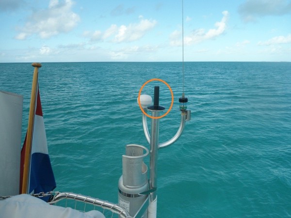
What is important is to have a good antenna, as the satellite signals are weak. So it is cost effective to purchase an outside aerial. The phone itself typically comes with a small magnet mounted antenna, typically used in cars, however you are better off I believe with dedicated large size iridium antenna, despite the cost. You will recover that cost in saving in minutes, as your connection should be better. Our dedicated external antenna is mounted on an aft pedestal, away from any obstructions. I purposely did not install it in the top of one of our masts. The reason was that I have experienced in the past while working on offshore construction vessels that in case of heavy vessel movement, it regularly lost signal while making a call. I was concerned that mounting it on a top of a mast would have the antenna move to much (too violent) causing loss of signal.
You can select to omit the docking station and external antenna. I found the docking station very expensive for what it really is. However in the end we choose to have one for the reason that now the Satellite phone is always 100% charged (always on charging while in the docking station). In case of an emergency and we would have to leave the boat, the phone goes with us. We have now the reassurance that if we end up in the life raft with the satellite phone, it is charged 100%. Naturally it is also more convenient and less cluttering, as all wires go to the docking station and remain permanently connected (external antenna, power cord, connection to hand set, USB cable to laptop.) We have emergency numbers programmed in the phonebook, such as the maritime distress centers around the globe. So in the unfortunate situation in where things do go terrible wrong a simply press of the call button on a phone number in the phones' phonebook will have you call directly to your selected distress center.
Also due to the phone always being in the "switched on" position, you can always be reached if required. I know that is something we all try to evade, and often a major reason for going cruising around the globe, the possibility of that you cannot be contacted at any moment's notice. However there are often people around you that you would like to be able to reach you on case of an emergency, such as relatives or work related. With both myself and my wife having family in different parts of the world it is reassuring to know that they can reach us if needed immediately by simply dialing our number.
A note of caution, calling from land lines quickly becomes very costly for both call parties as many providers around the globe charge extraordinary when a landline calls a satellite number. GMN specifically warns you of that and actually provides you with two different suggestions how land based numbers can call you, the one typically a cheaper way then the other. We have indeed confirmed that calling from certain land numbers to our phone can bring very high charges to that party that calls you. So it is imperative you instill this on anyone you give your satellite phone number to. We use it therefore strictly for emergency really and clearly advice anyone who gets our number about possible extravagant cost in case it is used. We use internet based calling like Skype to have our regular phone calls once we have good high speed internet connections available.
For us the capability to be reached in emergency brings just a level of assurance that is commonly available nowadays while travelling with your family and I will not shy from using if ever a situation requires me to.
Besides the phone capability, our primary use is email and weather. This set up provides email capability; 24hr's a day, anywhere in the world. The GMN compression software comes with an email handling program, which has the look and feel of many well-known email programs such as MS Outlook and Eudora. You write, read and file your emails in this program (Called "Iscribe" at GMN). Anyone who has ever send emails will be able to use this program without using a manual or any training.
Once done with writing your emails, you press the "send" button. The program (Iscribe) places the written email in the "outbox" of the compression software X-Gate. This all goes by itself, you do not see it, nor does it require your input. Once you are ready to send and receive emails, you open "X-Gate" the email compression program that also manages the connection with the Iridium phone and the shore side server. Again this piece of software is set up such that anyone who has sent an email in his life can use this program.
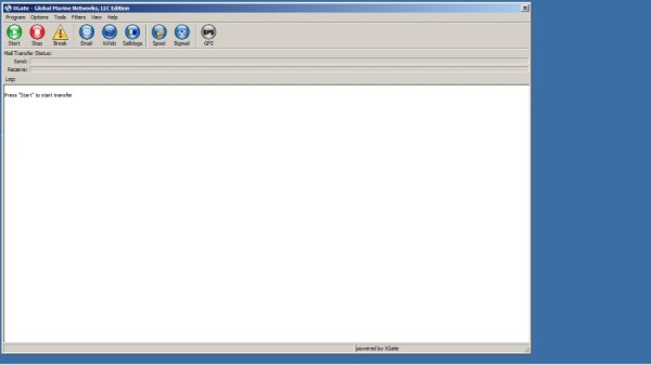
It contains a large green button "Start". You simply click this button, the program will connect to the iridium phone (provided you have connected the iridium, phone with an USB cable to your Laptop) and the program sends your emails and download waiting emails for you from the GMN mail server. Here the compression software does it work, sending and downloading email goes relative fast. A few emails and a simple grib file are send and downloaded in approximately 1 minute. Connection data rates are very low on a satellite phone (9600Kb), in this time of age, disappointing low. So the compression software is a must in this set up. Do not try to send emails without compression software. The efficiency of the compression software becomes very obvious when you connect via a normal internet connection and still use GMN X-Gate software. The connection goes so fast, that we sometimes use it when we have a very poor common internet connection via WiFi. The X-Gate program still pulls down the weather charts in less than a few seconds while web pages stall.
Via the satellite we can send and download approximately 5 to 10 text only (short) emails per minute. We have a 500 minute pre-paid plan, which comes down to a 1.25 USD per minute charged at 20 seconds interval (if you use the phone 1 minute and 20 seconds, you are being charged 80 seconds, not two full minutes).
Since we have now email, we can get weather files, weather faxes, grib files and written forecast per email. There is a large quantity of weather products available for download via low bandwidth systems. Some are at a cost, some are for free.
For the mid latitude's we prefer the grib files that draws from any of the available government owned forecast models. At our current location (Caribbean) we typically draw from the GFS model and we select wind charts, in where the wind strength and direction is indicated over a pre-selected area in wind barbs. You can also select to view "rain", this is very useful if you want to see the fronts coming, where typically the rain foregoes the front. On the internet there are also free options available to download weather faxes (drawn up weather charts) that show the fronts, troughs and isobars etc. You can draw your own conclusion then on what type of weather to expect. This is something I would certainly explore when sailing in the high latitudes. However I firmly believe that you will have to be quite experienced and knowledgeable about weather systems if you want to prepare a weather forecast with a higher level of accuracy then computer models nowadays, particular over larger areas.
For sailing in the high latitude's or areas affected by landmasses, I would use weather faxes and written forecasts to identify localized weather phenomena that could bring unexpected blows. Note that for our trip from Houston to Key West in the Gulf of Mexico in October (still Hurricane season), we always used written forecasts, combined with the GFS model wind charts. I would not rely on GFS model only there. (The limitation of the GFS model became painfully obvious that time in a small but strong tropical storm which had developed unexpectedly offshore Mexico Yucutan coast. It was from start clearly being described in the written forecasts with position reports of the center (and winds in the 45 to 55 knots range), however it only showed up on the GSF grib files after day three. Due to it being a localized event, a small sized system, the GFS model had not forecasted it.)
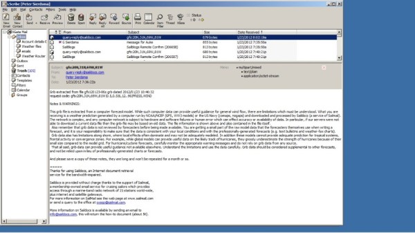
I found the warning Saildocs includes in its grib file emails is very clear and to the point;
Quote;
Notes & WARNINGS:
This grib file is extracted from a computer forecast model. While such computer data can provide useful guidance for general wind flow, there are limitations which must be understood. What you are receiving is a weather prediction generated by a computer run by NOAA/NCEP (GFS, WW3 models) or the US Navy (comaps, nogaps) and downloaded and processed by Saildocs (a service of Sailmail). The network is complex, and any computer network is subject to hardware and software failures or human error which can effect accuracy or availability of data. In particular, if our servers were not able to download a current data file then the grib-file may be based on old data. The file information is shown above and also contained in the file itself.
Also remember that grib data is not reviewed by forecasters before being made available. You are getting a small part of the raw model data that the forecasters themselves use when writing a forecast, and it is your responsibility to make sure that the data is consistent with your local conditions and with the professionally-generated forecasts (e.g. text bulletins and weather-fax charts).
Grib data also has limitations along shore, where local effects often dominate and may not be adequately modeled. In addition these models cannot provide adequate prediction for tropical systems, frontal activity or convergence zones. For example, while global models can provide useful data on the likely track of hurricanes, they grossly underestimate the strength of hurricanes because of their small size compared to the model grid. For hurricane/cyclone forecasts, carefully monitor the appropriate warning messages and do not rely on grib data from any source.
That all said, grib data can provide useful guidance not available elsewhere. Understand the limitations and use the data carefully. Grib data should be considered supplemental to other forecasts, and not be relied upon in lieu of professionally-generated charts or forecasts.
Unquote.
In any case, we have now access to all weather forecasting systems via our Satellite phone and laptop.
As mentioned, here in the Caribbean with the mild weather systems we are fine with requesting and downloading grib files from the GFS model.
Weather charts must be of the Grib format. Any other format is simply too large in size and becomes quickly cost prohibitive as the time to download will be long.
We typically draw Grib files from the GFS model via Saildocs.com. This is a service from sailmail. The US government also provides for the requesting and downloading of grib files from their GFS model directly. However I found their email commands to do this rather cumbersome and unclear and often my request was denied with a comment, "not authorized". The NOAA website provides instructions how to do this directly.
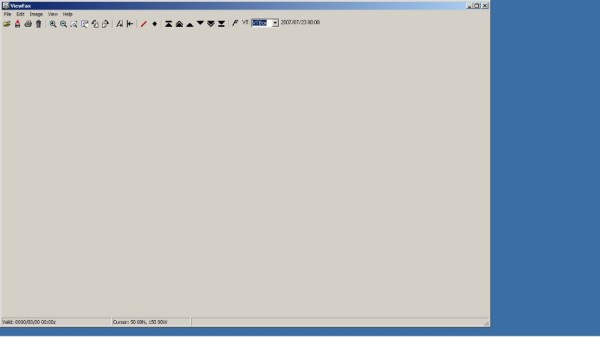
The grib files must be viewed in a viewer. We use Viewfax, a freely available program that works excellent and has all the required functions you need to review weather files. Viewfax provides a clear picture, is very easy to operate and you have the ability to place your position and heading on the screen. There are several other grib viewers available, some at a cost, some for free. The "viewers" you have the pay for typically have many more viewing options which I personally doubt you need, as the grib files itself just contains pressure, wind and rain data.
To request a grib file, you send a certain predefined code to the grib file provider (robot). The grib robot provider will have these instruction send to you, typically be sending a blank email to them. In our case we use Saildocs. We like the set up they have created an excellent clear and straight forward grib file robot.
By sending a blank email to saildocs, the robot will send you back the code instructions. There are typically many possibilities to request for download. In reality you quickly settle on one or two items every time, so you send the same emails every time requesting the same product.
To give you an idea, this is the code we use for Saildocs for requesting a grib file showing pressure, wind and rain for a selected area. Note that any other robot has it's own commands / codes.
gfs:20N,31N,69W,81W|0.5,0.5|6,12..96|PRESS,WIND,RAIN
• GFS is the model we request to draw from
• Lat and Lon for the area you wish to cover (a box) (the larger the area, the larger the file)
• Grid spacing. If you select 1 or 2 degrees, the size of the file becomes (much) smaller (less data) but contains less detail. Here we selected 0.5 degree.
• 6,12..96 indicates the hours you want to be forecasted (4 days total, note that the accuracy diminishes quickly after day two or three in my experience. So anything beyond day three is a mere indication for me about what we possible might see in the winds. The first 48 hours are typically good. Note that this is as well the case with forecasts by meteorologist, I personally do not place value in any forecast beyond the three days. The so called long term forecast covering 7 and sometime 10 days are in my opinion noting more valuable than looking at statistics for the region.)
And last;
• The items you want to download and view. In this case we have selected Pressure (showing isobars), Wind (showing classic wind barbs), and Rain (showing area of high rainfall, typically associated with fronts)
Now you press the start button of X-Gate on your laptop, it connects the satellite phone with the shore side server (X-Gate shows you in the process every steps it does, including the time in seconds it takes). It sends out your Grib file request, checks and downloads if there is mail for you waiting on the server and "hangs up" (disconnect) the satellite phone.
Now you wait a few minutes and connect again (nothing more than again pressing the large green start button on X-Gate). X-Gate will check for mail on the server and will now find the requested grib file which it downloads. It shows you the progress of downloading and once fully downloaded immediately disconnect the phone (hangs up). Note these are selectable options, you can also leave the phone connected if you desire and hang up yourself. We have it set up such that we have the minimum time connected as required to ensure cost remains "relative" low.
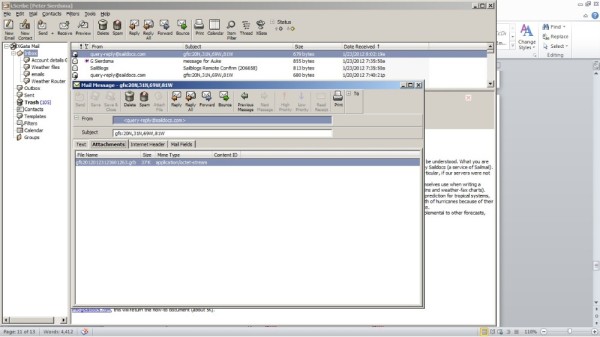
Now you have the email containing the grib file as attachment. We save the grib attachment to a folder. In our case we have to include the extension .grb behind the filename, as our windows does not recognize the file and as such does not produce the extension itself.
Once we have filed the grib file, we open "Viewfax" and with the common "file open" function click on the just saved grib file. Viewfax will now display the weather chart and by clicking on the arrows at the top you can scroll through the charts at 6 hour intervals.
The below is the chart produced from the above described command. You clearly see the rain band in the upper right corner in grey colors, showing the front and the wind change that will occur behind the front.
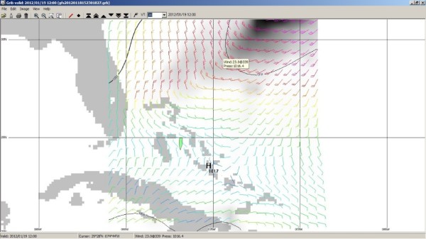
You have to be careful with the level of detail you request. You quickly increase the size of the file and as such the time to download and it can become costly quickly. We typically select on a large grid (less detail) and we often do not select RAIN, less data to download. Typical charts with less detail then the above you download typically within a minute, which cost us in our case 1.25 USD. In my opinion a well spend 1.25 USD for a weather chart (we typically at the same time of sending a grib file request, we send an position update to our blog, often appreciated by family and friends).
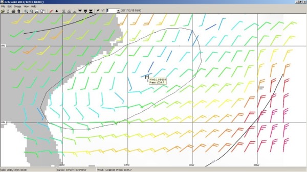
A grib file chart with much less detail (less data) and thus less time to download is shown below. Note the below chart covers a different area then the above displayed chart. The below chart was actually downloaded while sailing offshore Northwards towards Charleston on the US East coast. The above chart was recently downloaded while in the Bahamas, sailing from the Abacos to the Exumas.
So in this set up the Satellite phone has proven to be a very valuable system for us and a cost effective way to download weather, both grib files, written forecasts and weather faxes and send and receive emails (without attachments). It has proven to be very simple to set up and is a highly reliable system. The system is always "On" on board Mundinho and so far has not given us any issues.
It is cost effective for downloading weather. However for direct calling or being called it quickly become cost prohibitive in our opinion. We used the phone several times when Heloisa travelled from Houston to Mundinho, while we were on the anchorage of Key West. She would come to the dockside and we would collect her with the dinghy. The Miami airport shuttle Van driver did not have a clue where to drop her off, so we ended up calling each other a few times (Me from board with the sat phone to her US mobile phone) to ensure we would find each other. A month later we received Heloisa mobile phone bill. I still shiver in my bed thinking about that bill.
Prior our departure we decided we wanted to have the ability to receive weather files on board in one form or the other. We also liked the idea to have something on board that ensured our family could reach us in an emergency if really required. Since Heloisa's mother is at age and not doing too well health wise, we found this comforting knowing that the home front could reach us at any time if required. Also travelling with a 7 year old to some "off the beaten track" places as we have planned, we gain comfort knowing that if we end up in a medical emergency with our son, we can access medical knowledge at any time anywhere in the world. It is all not an absolute necessity for us, however it gives us comfort.
For weather we have Navtex on board, which is a good and reliable source for weather while relative close to the coast and is a good reliable source to watch for tropical storm development. However in addition I really desired the capability to be able to download some easy to read wind charts on board that show wind direction and strengths for any upcoming three days at any time, independent the location.
The US and some European countries developed and maintain software models that predict winds around the globe or locally for their regions. The software models typically provide a basis for detailed forecasting weather around the globe. These software models can provide weather charts upon request for any selected area (grid in Lat and Lon) with a selected level of detail. The grid spacing that normally can be used is 2 degrees, 1 degree and 0.5 degrees. The files that can be requested are called Grib files (GRidded Information in Binary (GRIB) files).
Frank Singleton, a UK Met office weather man on his website http://weather.mailasail.com/Franks-Weather/Saildocs-Free-Grib-Files gives a good run-down on what grib files are. In the initial years after their commencement these software models left a lot to desire with regards to accuracy. Nowadays the major models such as the US owned and maintained GFS worldwide model I have found to be very acceptable in accuracy, certainly accurate enough for most sailing / cruising conditions in the middle latitudes and when used in addition to Navtex suitable for higher latitudes. There are some limitations such as land masses affecting the model, so you have to use the model results with caution while sailing close to the coast of major landmass. Also I have found the wind strength is often 3 to 5 knots higher in reality then predicted in the model (note in reality the sustained winds are often 3 to 5 knots higher, we are not referring to wind gusts). There is some good writing available about using grib files. Anyone using grib weather files should read up about its limitations. One often mentioned limitation with the GFS and similar model outputs is that it is not vetted by a meteorologist. You receive raw data straight from a very large computer. Written forecasts have typically been generated by meteorologist, a physical person looking over the date and drawing up a conclusion.
We have found the GFS and similar models a great weather (wind) source and I am fairly convinced many independent weather forecasters and companies providing weather forecast to individuals for a cost, draw a lot on these software models nowadays. Another limitation is the fact that the model "looks" over large areas. It does not look at small areas. A local weather burst will go unnoticed by the GSF model. We do not find that so much of an issue, as any local happening typically will not last long. I do not get overly concerned if we end up in 35 knots winds locally if it is just for a few hours. I would get concerned if it would last days, but in that case the model has typically forecasted it as the system is much larger in size and as such you would have observed it in your grib files.
Cross checking against the Navtex and VHF provided forecasts is always good and we typically do in case we do not like the forecast (we typically do not like it when "high" winds are forecasted).
The set up;
I always have a strong desire to have systems on board that are truly very simple and truly very reliable to operate. I know from my own experience that once offshore and particular in not so nice weather conditions, the first few days after departure (not having my "sea legs" yet in those first days), I am not keen on having to spend prolonged periods inside the cabin behind a chart table to get anything done. Weather files can and often are crucial for a good, efficient and safe trip, be it a short 40 miles offshore hop or a 400 Nm offshore trip, so I had myself set the requirement that to get good weather files the way should be easy and reliable at all times. ("Press of the button" type easy)
To get weather grib files (or other weather reports via email) while offshore or in areas where you do not have internet access, the typical cruiser has realistically nowadays two reliable and cost effective options to choose from (there are more options however these are either much more costly, (used in professional environments) or not having known proven reliability. The two options are either installing an SSB radio (transceiver) with Pactor modem or a Satellite phone connected to a laptop loaded with compression software.
We choose for a Satellite phone. The reason for this choice is simply I am most comfortable with the operation of this equipment, which is the same as a regular cellphone and I am comfortable with the level of reliability (virtually every time a connection when you want / need it). I have spoken to cruisers with SSB installation on board, and they have assured me that their reliability is equally high (connection every time they want / need it).
The purchase cost of a Satellite phone system is lower than a SSB installation however the operating cost is higher of the phone. For us the satellite phone with laptop set up has proven to be a most reliable and cost effective solution, capable of downloading grib weather files and regular emails (text only).
The system contains the following items;
• 1 satellite phone, Iridium.
• 1 external Iridium antenna
• 1 docking station with handset
• 1 laptop (there is no dedicated laptop. We use the same laptop we use for everything such as emails, internet, pictures etc.)
• Satellite phone driver software for your laptop.
• Email compression software (X-Gate from GMN)
• Email Handling software (Iscribe, from GMN it is integrated in the compression software, only one software package you will have to install)
• Phone sim card for phone activation
• Prepaid Iridium minutes
We have purchased all items (except laptop) from one provider. I believe by using one provider you simplify the set up and can often safe you a lot of hassle trying to get the items to work with each other. In theory communication protocols used are normally standard, so should work, irrespective the providers, however that is not my experience in reality.
We used GMN (Global Marine Networks) as provider for all items. There are several other well-known companies who can provide all items. Pricing is everywhere very similar, although it does not always appear to be similar. Once you calculate the totals, you are always back to about the same. I do not have experience with other providers, only with GMN. GMN has been excellent in supplying the items and very responsive to any queries I had. The installation of the antenna, phone, docking station and the GMN proprietary compression software was all very straight forward and did not require me to get any help from "outside". The docking station was the only item that gave me some puzzling, as the actual item contained two wires not described in the one page installation manual. A quickly answered email from the supplier of the item to GMN, forwarded to me brought the solution.
The Satellite phone driver comes on a CD-rom, you will need it in order for your laptop to be able to work with the Iridium phone and is a straight forward driver, similar is when you buy a printer and you need to install the driver prior using the printer. The X-Gate and Iscribe software come on one CD-rom and installs like any other software you purchase. You can also download the software their website which we did. Afterwards we ordered the software on CD-rom as we wanted to have thee software available on board in order to reinstall quickly in case of a laptop failure and being independent from an internet connection. Overall the whole set up is very straight forward and it has worked from the start and has never in the six months we are using it given us a single hick up.
What is important is to have a good antenna, as the satellite signals are weak. So it is cost effective to purchase an outside aerial. The phone itself typically comes with a small magnet mounted antenna, typically used in cars, however you are better off I believe with dedicated large size iridium antenna, despite the cost. You will recover that cost in saving in minutes, as your connection should be better. Our dedicated external antenna is mounted on an aft pedestal, away from any obstructions. I purposely did not install it in the top of one of our masts. The reason was that I have experienced in the past while working on offshore construction vessels that in case of heavy vessel movement, it regularly lost signal while making a call. I was concerned that mounting it on a top of a mast would have the antenna move to much (too violent) causing loss of signal.
You can select to omit the docking station and external antenna. I found the docking station very expensive for what it really is. However in the end we choose to have one for the reason that now the Satellite phone is always 100% charged (always on charging while in the docking station). In case of an emergency and we would have to leave the boat, the phone goes with us. We have now the reassurance that if we end up in the life raft with the satellite phone, it is charged 100%. Naturally it is also more convenient and less cluttering, as all wires go to the docking station and remain permanently connected (external antenna, power cord, connection to hand set, USB cable to laptop.) We have emergency numbers programmed in the phonebook, such as the maritime distress centers around the globe. So in the unfortunate situation in where things do go terrible wrong a simply press of the call button on a phone number in the phones' phonebook will have you call directly to your selected distress center.
Also due to the phone always being in the "switched on" position, you can always be reached if required. I know that is something we all try to evade, and often a major reason for going cruising around the globe, the possibility of that you cannot be contacted at any moment's notice. However there are often people around you that you would like to be able to reach you on case of an emergency, such as relatives or work related. With both myself and my wife having family in different parts of the world it is reassuring to know that they can reach us if needed immediately by simply dialing our number.
A note of caution, calling from land lines quickly becomes very costly for both call parties as many providers around the globe charge extraordinary when a landline calls a satellite number. GMN specifically warns you of that and actually provides you with two different suggestions how land based numbers can call you, the one typically a cheaper way then the other. We have indeed confirmed that calling from certain land numbers to our phone can bring very high charges to that party that calls you. So it is imperative you instill this on anyone you give your satellite phone number to. We use it therefore strictly for emergency really and clearly advice anyone who gets our number about possible extravagant cost in case it is used. We use internet based calling like Skype to have our regular phone calls once we have good high speed internet connections available.
For us the capability to be reached in emergency brings just a level of assurance that is commonly available nowadays while travelling with your family and I will not shy from using if ever a situation requires me to.
Besides the phone capability, our primary use is email and weather. This set up provides email capability; 24hr's a day, anywhere in the world. The GMN compression software comes with an email handling program, which has the look and feel of many well-known email programs such as MS Outlook and Eudora. You write, read and file your emails in this program (Called "Iscribe" at GMN). Anyone who has ever send emails will be able to use this program without using a manual or any training.
Once done with writing your emails, you press the "send" button. The program (Iscribe) places the written email in the "outbox" of the compression software X-Gate. This all goes by itself, you do not see it, nor does it require your input. Once you are ready to send and receive emails, you open "X-Gate" the email compression program that also manages the connection with the Iridium phone and the shore side server. Again this piece of software is set up such that anyone who has sent an email in his life can use this program.
It contains a large green button "Start". You simply click this button, the program will connect to the iridium phone (provided you have connected the iridium, phone with an USB cable to your Laptop) and the program sends your emails and download waiting emails for you from the GMN mail server. Here the compression software does it work, sending and downloading email goes relative fast. A few emails and a simple grib file are send and downloaded in approximately 1 minute. Connection data rates are very low on a satellite phone (9600Kb), in this time of age, disappointing low. So the compression software is a must in this set up. Do not try to send emails without compression software. The efficiency of the compression software becomes very obvious when you connect via a normal internet connection and still use GMN X-Gate software. The connection goes so fast, that we sometimes use it when we have a very poor common internet connection via WiFi. The X-Gate program still pulls down the weather charts in less than a few seconds while web pages stall.
Via the satellite we can send and download approximately 5 to 10 text only (short) emails per minute. We have a 500 minute pre-paid plan, which comes down to a 1.25 USD per minute charged at 20 seconds interval (if you use the phone 1 minute and 20 seconds, you are being charged 80 seconds, not two full minutes).
Since we have now email, we can get weather files, weather faxes, grib files and written forecast per email. There is a large quantity of weather products available for download via low bandwidth systems. Some are at a cost, some are for free.
For the mid latitude's we prefer the grib files that draws from any of the available government owned forecast models. At our current location (Caribbean) we typically draw from the GFS model and we select wind charts, in where the wind strength and direction is indicated over a pre-selected area in wind barbs. You can also select to view "rain", this is very useful if you want to see the fronts coming, where typically the rain foregoes the front. On the internet there are also free options available to download weather faxes (drawn up weather charts) that show the fronts, troughs and isobars etc. You can draw your own conclusion then on what type of weather to expect. This is something I would certainly explore when sailing in the high latitudes. However I firmly believe that you will have to be quite experienced and knowledgeable about weather systems if you want to prepare a weather forecast with a higher level of accuracy then computer models nowadays, particular over larger areas.
For sailing in the high latitude's or areas affected by landmasses, I would use weather faxes and written forecasts to identify localized weather phenomena that could bring unexpected blows. Note that for our trip from Houston to Key West in the Gulf of Mexico in October (still Hurricane season), we always used written forecasts, combined with the GFS model wind charts. I would not rely on GFS model only there. (The limitation of the GFS model became painfully obvious that time in a small but strong tropical storm which had developed unexpectedly offshore Mexico Yucutan coast. It was from start clearly being described in the written forecasts with position reports of the center (and winds in the 45 to 55 knots range), however it only showed up on the GSF grib files after day three. Due to it being a localized event, a small sized system, the GFS model had not forecasted it.)
I found the warning Saildocs includes in its grib file emails is very clear and to the point;
Quote;
Notes & WARNINGS:
This grib file is extracted from a computer forecast model. While such computer data can provide useful guidance for general wind flow, there are limitations which must be understood. What you are receiving is a weather prediction generated by a computer run by NOAA/NCEP (GFS, WW3 models) or the US Navy (comaps, nogaps) and downloaded and processed by Saildocs (a service of Sailmail). The network is complex, and any computer network is subject to hardware and software failures or human error which can effect accuracy or availability of data. In particular, if our servers were not able to download a current data file then the grib-file may be based on old data. The file information is shown above and also contained in the file itself.
Also remember that grib data is not reviewed by forecasters before being made available. You are getting a small part of the raw model data that the forecasters themselves use when writing a forecast, and it is your responsibility to make sure that the data is consistent with your local conditions and with the professionally-generated forecasts (e.g. text bulletins and weather-fax charts).
Grib data also has limitations along shore, where local effects often dominate and may not be adequately modeled. In addition these models cannot provide adequate prediction for tropical systems, frontal activity or convergence zones. For example, while global models can provide useful data on the likely track of hurricanes, they grossly underestimate the strength of hurricanes because of their small size compared to the model grid. For hurricane/cyclone forecasts, carefully monitor the appropriate warning messages and do not rely on grib data from any source.
That all said, grib data can provide useful guidance not available elsewhere. Understand the limitations and use the data carefully. Grib data should be considered supplemental to other forecasts, and not be relied upon in lieu of professionally-generated charts or forecasts.
Unquote.
In any case, we have now access to all weather forecasting systems via our Satellite phone and laptop.
As mentioned, here in the Caribbean with the mild weather systems we are fine with requesting and downloading grib files from the GFS model.
Weather charts must be of the Grib format. Any other format is simply too large in size and becomes quickly cost prohibitive as the time to download will be long.
We typically draw Grib files from the GFS model via Saildocs.com. This is a service from sailmail. The US government also provides for the requesting and downloading of grib files from their GFS model directly. However I found their email commands to do this rather cumbersome and unclear and often my request was denied with a comment, "not authorized". The NOAA website provides instructions how to do this directly.
The grib files must be viewed in a viewer. We use Viewfax, a freely available program that works excellent and has all the required functions you need to review weather files. Viewfax provides a clear picture, is very easy to operate and you have the ability to place your position and heading on the screen. There are several other grib viewers available, some at a cost, some for free. The "viewers" you have the pay for typically have many more viewing options which I personally doubt you need, as the grib files itself just contains pressure, wind and rain data.
To request a grib file, you send a certain predefined code to the grib file provider (robot). The grib robot provider will have these instruction send to you, typically be sending a blank email to them. In our case we use Saildocs. We like the set up they have created an excellent clear and straight forward grib file robot.
By sending a blank email to saildocs, the robot will send you back the code instructions. There are typically many possibilities to request for download. In reality you quickly settle on one or two items every time, so you send the same emails every time requesting the same product.
To give you an idea, this is the code we use for Saildocs for requesting a grib file showing pressure, wind and rain for a selected area. Note that any other robot has it's own commands / codes.
gfs:20N,31N,69W,81W|0.5,0.5|6,12..96|PRESS,WIND,RAIN
• GFS is the model we request to draw from
• Lat and Lon for the area you wish to cover (a box) (the larger the area, the larger the file)
• Grid spacing. If you select 1 or 2 degrees, the size of the file becomes (much) smaller (less data) but contains less detail. Here we selected 0.5 degree.
• 6,12..96 indicates the hours you want to be forecasted (4 days total, note that the accuracy diminishes quickly after day two or three in my experience. So anything beyond day three is a mere indication for me about what we possible might see in the winds. The first 48 hours are typically good. Note that this is as well the case with forecasts by meteorologist, I personally do not place value in any forecast beyond the three days. The so called long term forecast covering 7 and sometime 10 days are in my opinion noting more valuable than looking at statistics for the region.)
And last;
• The items you want to download and view. In this case we have selected Pressure (showing isobars), Wind (showing classic wind barbs), and Rain (showing area of high rainfall, typically associated with fronts)
Now you press the start button of X-Gate on your laptop, it connects the satellite phone with the shore side server (X-Gate shows you in the process every steps it does, including the time in seconds it takes). It sends out your Grib file request, checks and downloads if there is mail for you waiting on the server and "hangs up" (disconnect) the satellite phone.
Now you wait a few minutes and connect again (nothing more than again pressing the large green start button on X-Gate). X-Gate will check for mail on the server and will now find the requested grib file which it downloads. It shows you the progress of downloading and once fully downloaded immediately disconnect the phone (hangs up). Note these are selectable options, you can also leave the phone connected if you desire and hang up yourself. We have it set up such that we have the minimum time connected as required to ensure cost remains "relative" low.
Now you have the email containing the grib file as attachment. We save the grib attachment to a folder. In our case we have to include the extension .grb behind the filename, as our windows does not recognize the file and as such does not produce the extension itself.
Once we have filed the grib file, we open "Viewfax" and with the common "file open" function click on the just saved grib file. Viewfax will now display the weather chart and by clicking on the arrows at the top you can scroll through the charts at 6 hour intervals.
The below is the chart produced from the above described command. You clearly see the rain band in the upper right corner in grey colors, showing the front and the wind change that will occur behind the front.
You have to be careful with the level of detail you request. You quickly increase the size of the file and as such the time to download and it can become costly quickly. We typically select on a large grid (less detail) and we often do not select RAIN, less data to download. Typical charts with less detail then the above you download typically within a minute, which cost us in our case 1.25 USD. In my opinion a well spend 1.25 USD for a weather chart (we typically at the same time of sending a grib file request, we send an position update to our blog, often appreciated by family and friends).
A grib file chart with much less detail (less data) and thus less time to download is shown below. Note the below chart covers a different area then the above displayed chart. The below chart was actually downloaded while sailing offshore Northwards towards Charleston on the US East coast. The above chart was recently downloaded while in the Bahamas, sailing from the Abacos to the Exumas.
So in this set up the Satellite phone has proven to be a very valuable system for us and a cost effective way to download weather, both grib files, written forecasts and weather faxes and send and receive emails (without attachments). It has proven to be very simple to set up and is a highly reliable system. The system is always "On" on board Mundinho and so far has not given us any issues.
It is cost effective for downloading weather. However for direct calling or being called it quickly become cost prohibitive in our opinion. We used the phone several times when Heloisa travelled from Houston to Mundinho, while we were on the anchorage of Key West. She would come to the dockside and we would collect her with the dinghy. The Miami airport shuttle Van driver did not have a clue where to drop her off, so we ended up calling each other a few times (Me from board with the sat phone to her US mobile phone) to ensure we would find each other. A month later we received Heloisa mobile phone bill. I still shiver in my bed thinking about that bill.
Electronic Charting (Plotter) and Radar
08 May 2011
On Mundinho we try to keep everything simple, this is also the case with regards to navigation equipment. I prefer systems that are not linked and / or dependent of each other. In this way set up, the failure of one will not affect the other. The principal GPS is a basic bullet proof Furuno GP-32 model. No fuzz, just Lat and Lon.
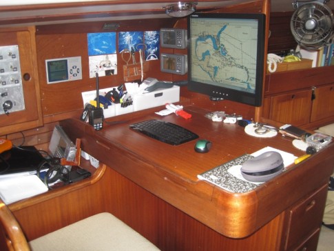
On a small notebook we run C-Map PC planner software. In front of the chart table is a 19-inch LCD screen positioned with feed from the note book. During normal offshore sailing trips, commonly I plot my position from the Furuno GPS in C-Map PC planner software on C-Maps, which runs on the notebook. This is a manual process, just as you conventionally marked your position on your paper charts. On large crossing we do this every three hours. On shorter trips or coastal trips every hour. The marks remain on the chart, for me this is handy for future reference. As the notebook goes into sleep mode after 10 minutes, including the large 19 inch screen, the power consumption is minimal compared to a large plotter. I choose a notebook versus a laptop again for the redcued power consumption (we carry laptops on board for email and administartion, pictures editing etc) The power consumption of the GPS is minimal as well, due to it's small (4 inch) grey scale only screen.
I like to use normally C-Map MAX for electronic charts. Specifically the large coverage such as North and South America. This allows me zooming and panning without changing (uploading of new charts). I carry some other vector and raster charts on the notebook, however in reality the C-Map MAX covers all I really need in addition to some large scale paper charts I carry.
For me a key reason for choosing C-Maps was the fact that is produced by a large company providing maps to the commercial industry (Jeppesen, aviation maps, (a Boeing Company)). Continuity is important for me and the quality of maps for the aviation industry has always impressed me when I still regularly was flying single engine planes. I have seen several other electronic maps systems which appear better in certain details. However overall the best choice was C-Map MAX for me with regards to worldwide coverage, update possibilities, large company behind it, large regions, and compatible with quality plotters.
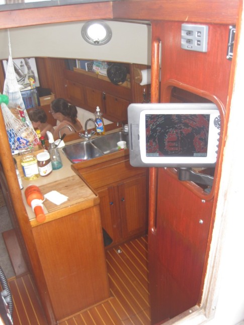
On most sailing trips I do not need a plotter "stand by" all the time, really only at approaches or departures or tricky navigational areas. For those moments we desire to have any moment continuous awareness of our location directly against the background of a map plotted we use a Northstar plotter with 10" screen at the cabin entrance on a swinging arm. The plotter is good visible and directly reachable from the steering position. We use the same C-Map cartridge for the map. The plotter is fed by its own GPS antenna, so there is some redundancy here.
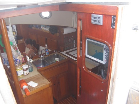
For radar we have a broadband (BR-24) radar from Simrad on board mounted in the aft mast. This is really a neat piece of gear. We use the Northstar plotter as display for the radar. Broadband radar is a new radar system, different from the X and S band type radars. The technology has been around for years, mainly used by the military and in the aviation industry for ground proximity radars. The major advantage of conventional radars is the much better resolution on short range to ultra-short range (1/8 miles or less range). The quality (resolution / target definition) gets lower than conventional radar beyond the 10 miles range. In reality when we need radar it is virtually always in the 1/8 to 6 nautical miles range. For approaches we use it in the ¼ to 1 miles range, while at open water to monitor shipping, the 6 miles range works best for us. The really only times when a conventional radar would be better suited would be for watching for rains squalls at 15 to 20 miles range. The reality is however we normally see the squalls coming in time to reduce our sails. As we have a simple but very effective slab reef system, we need only very little time to reef the main or mizzen and never need to change course for that, often not even change the boom position.
The low power consumption compared to conventional radars is an additional major plus for us as we do not have much power reserve available in battery capacity and we are not every keen on many engine hours for charging the batteries. The radar consumes zero Amps on stand by and 1.1 Amps while transmitting. The plotter consumes 1.2 Amps as well, so totally the consumption is 2.3 Amps in transmit mode. At night we often switch the radar transmitting off, with the radar on standby (display "on"). This is zero Amps. Then at 15 minutes intervals we press "transmit", we leave this on for 5 minutes and switch it off again if there is nothing of interest.
On a small notebook we run C-Map PC planner software. In front of the chart table is a 19-inch LCD screen positioned with feed from the note book. During normal offshore sailing trips, commonly I plot my position from the Furuno GPS in C-Map PC planner software on C-Maps, which runs on the notebook. This is a manual process, just as you conventionally marked your position on your paper charts. On large crossing we do this every three hours. On shorter trips or coastal trips every hour. The marks remain on the chart, for me this is handy for future reference. As the notebook goes into sleep mode after 10 minutes, including the large 19 inch screen, the power consumption is minimal compared to a large plotter. I choose a notebook versus a laptop again for the redcued power consumption (we carry laptops on board for email and administartion, pictures editing etc) The power consumption of the GPS is minimal as well, due to it's small (4 inch) grey scale only screen.
I like to use normally C-Map MAX for electronic charts. Specifically the large coverage such as North and South America. This allows me zooming and panning without changing (uploading of new charts). I carry some other vector and raster charts on the notebook, however in reality the C-Map MAX covers all I really need in addition to some large scale paper charts I carry.
For me a key reason for choosing C-Maps was the fact that is produced by a large company providing maps to the commercial industry (Jeppesen, aviation maps, (a Boeing Company)). Continuity is important for me and the quality of maps for the aviation industry has always impressed me when I still regularly was flying single engine planes. I have seen several other electronic maps systems which appear better in certain details. However overall the best choice was C-Map MAX for me with regards to worldwide coverage, update possibilities, large company behind it, large regions, and compatible with quality plotters.
On most sailing trips I do not need a plotter "stand by" all the time, really only at approaches or departures or tricky navigational areas. For those moments we desire to have any moment continuous awareness of our location directly against the background of a map plotted we use a Northstar plotter with 10" screen at the cabin entrance on a swinging arm. The plotter is good visible and directly reachable from the steering position. We use the same C-Map cartridge for the map. The plotter is fed by its own GPS antenna, so there is some redundancy here.
For radar we have a broadband (BR-24) radar from Simrad on board mounted in the aft mast. This is really a neat piece of gear. We use the Northstar plotter as display for the radar. Broadband radar is a new radar system, different from the X and S band type radars. The technology has been around for years, mainly used by the military and in the aviation industry for ground proximity radars. The major advantage of conventional radars is the much better resolution on short range to ultra-short range (1/8 miles or less range). The quality (resolution / target definition) gets lower than conventional radar beyond the 10 miles range. In reality when we need radar it is virtually always in the 1/8 to 6 nautical miles range. For approaches we use it in the ¼ to 1 miles range, while at open water to monitor shipping, the 6 miles range works best for us. The really only times when a conventional radar would be better suited would be for watching for rains squalls at 15 to 20 miles range. The reality is however we normally see the squalls coming in time to reduce our sails. As we have a simple but very effective slab reef system, we need only very little time to reef the main or mizzen and never need to change course for that, often not even change the boom position.
The low power consumption compared to conventional radars is an additional major plus for us as we do not have much power reserve available in battery capacity and we are not every keen on many engine hours for charging the batteries. The radar consumes zero Amps on stand by and 1.1 Amps while transmitting. The plotter consumes 1.2 Amps as well, so totally the consumption is 2.3 Amps in transmit mode. At night we often switch the radar transmitting off, with the radar on standby (display "on"). This is zero Amps. Then at 15 minutes intervals we press "transmit", we leave this on for 5 minutes and switch it off again if there is nothing of interest.
New Refrigeration + fridge insulation
27 March 2011
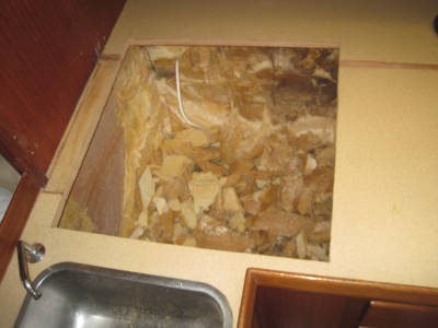
I finally got to the big job of upgrading the fridge insulation and installing a new fridge compressor with evaporator. For years I knew the insulation was poor of the fridge, simply because even at moderate temperatures the fridge would “kick-in” at regular short intervals.
Since I had to take part of the galley counter top apart to get access to the fridge insulation side, I was reluctant to get started on his .(The galley is owned by my wife and I require to kind of ask permission to get anything changed in the galley, the fact she does not have a very high confidence level in my ability to get any wood work done with great cosmetic result does not help me gaining the permission levels to attack the galley).
The main driver for the upgrade on the insulation was that I wanted to have a small fridge running virtually alone on solar power only while cruising. With a set up of 150 watt solar power, I knew more or less what size fridge I could run provided I had at least 18 R insulation installed of good quality.
Last week I took one week vacation from work and started cutting into the galley counter top to have access to the fridge box. The insulation I encountered confirmed my suspicion all along, being only around 4 cm thick foam type insulation, 20 years old, with many air pockets and pockets of glue only (no foam).
I removed all inside paneling, removed all foam insulation, gutted the whole fridge. What was left was an empty wooden shell.
First I installed one layer of 4mil plastic sheeting as moisture barrier. Next were 6 layers (bottom has 7 layers) of rigid foam insulation. The sheets were Owens Corning 1/2” thickness, sold at a local Home Depot. The R value of these sheets are 3 for a 1/2” thickness. My target was 7 panels, in order to achieve an R value of 20 plus. However the 6 layers already limited the internal space significantly compared to the original dimensions so I decided to stick to 6 panels at the sides and top and 7 panels at the bottom. This was followed by one layer of aluminum foil, with the shiny side facing outwards as radiant heat barrier. I finished all off with a layer of PVC sheeting sold at home depot for bathroom paneling, which gave it a clean appearance and will make it easy to clean while in use. All corners have been sealed with bathroom sealant in order to provide a watertight seal, all to prevent no moisture is leaking into the insulation panels. Any moisture in the insulation of a fridge is a terrible downgrade of the insulation capacity (moisture is a great hear transfer medium).
I was able to to use the fridge lid and lid frame. For the section I cut out of the counter top I used a 12mm marine lumber sheet. The fridge has since test run and so far the amp remain remarkable low over a 24 hour period, keeps the temperature nicely around the 4 degrees Celsius and we generates ice cubes within 6 hours. The outside temperatures are moderate at this time of the year, so I will be looking closely at the consumption as we go into the summer with soaring heat of Texas.
Next find some pictures on the project. All in all it cost me approximately 250 USD material from Home depot plus five days of work by myself plus 750 USD for the compressor with evaporator unit. Best of all it has received the approval of my wife, and my wife has gained a little more confidence in me that I can handle those jobs (I still need to ask permission however on subsequent execution of some “great ideas” I have)
| Vessel Name: | Mundinho |
| Vessel Make/Model: | Koopmans 42 - Ketch - Alu Centerboard |
| Hailing Port: | Harlingen - Holland |
| Crew: | Peter, Heloisa and Auke |
| About: | We are a family of three, a rather international get together with myself being Dutch, my lovely wife being Brazilian and our 7 year old son who carries a Dutch and Brazilian citizenship |
| Extra: | You can follow us here during our two year sailing trip that will take us together via the Caribbean and the Islands in the Pacific to New Zealand. Beyond that I will take Mundinho to Europe solo. |
| Home Page: | www.sv-mundinho.com |
Gallery not available
Family of three travelling West Bound (slowly)

Who: Peter, Heloisa and Auke
Port: Harlingen - Holland
All Blogs posted
Peter and Heloisa and their 7 year old son Auke are traveling with their sailing vessel a Koopmans 42. On this blog you can find updates regularly posted of their preparation and trip itself. Feel free to leave a message or raise a question if you have any for Peter and Heloisa.