
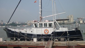
MV Shearwater
08 September 2013 | Kitchen Table
06 September 2013 | Admiralty Inlet
06 September 2013 | Mid Pacific
06 September 2013 | Off Oregon coast
06 September 2013 | Neah Bay
05 September 2013 | 47 42.7'N:125 27.6'W, 50nm from Wa entrance
04 September 2013 | 45 44.9'N:127 41.5'W, 197nm from Wa entrance
03 September 2013 | 43 51.3'N:130 07.0'W, 350nm from Wa entrance
02 September 2013 | 42 18.2'N:132 43.2'W, 498nm from Wa
01 September 2013 | 40 47.1'N:135 11.7'W, 636 nm from Wa
31 August 2013 | 40 23'N:138 20'W, 754 nm from Wa
30 August 2013 | 39 42.4'N:141 25.8'W, 882nm from Wa
29 August 2013 | 38 50.3'N:144 27.3'W, 1021nm from Wa
28 August 2013 | 37 18.7'N:146 40.4'W, 1160 nm from Wa
27 August 2013 | 34 41.2'N:148 30.1'W, 1292 nm from Wa
26 August 2013 | 34 11.0'N:150 23.5'W, 1420 nm from Wa
25 August 2013 | 32 25.1'N:152 21.8'W, 1565nm from Wa
24 August 2013 | 27 25.9'N:153 57.0'W, 1706 nm from Wa
23 August 2013 | 27 25.9'N:153 57.0'W, 1893 nm from Wa
23 August 2013 | 24 57.9'N:154 31.8'W, NE of Hawaii
779 nm to Hawaii Variables
23 June 2013 | 16 35.6'N:170 56.2'W, Near Johnston Atoll
David C
present position: 16deg 35.6' N 170deg 56.2' W COG 066 True, SOG 5.2kts
estimated 24hr position: 17deg 15.7'N 169deg 10.5' W
baro: 29.86, 24hr range 29.80-.90
wind: E 20kts, 24hr range 10-20kts
seas: 3meter, confused w/ wind chop
cloud cover: 60% cumulus, squall line to the north
summary: wind & seas picked up overnight, still doing over 5kts SOG, possibly due to movement of 400gal fuel forward from aft tank. 779 nm to Hawaii waypoint
Yesterday was great. See below 24h dist 140nm 113nm speed 5.83kts 4.71 Fuel 914g 988 Range 1737nm 1689nm to Hawaii 812 952 Reserve 926nm 745nm Reserve 487g 436g M.P.G. 1.9 1.71 6/23 6/22 Again thanks to Wade who has a lifetime of concern with these matters piloting 747's across the ocean. He wonders aloud sometimes why he is spending 14 weeks doing a crossing which took him 14 hours during his work years.
In making a long passage, one hopes to optimize all factors to get the most out of one's resources. Using the scientific method, one tries to identify variables and isolate each in an experimental fashion to arrive at a conclusion. As our improvement yesterday shows, there are multiple variables at play and are difficult to isolate. Weather was better with longer swell and diminished headwinds, measured set and drift were in our favor as the current had shifted in a NNE direction, we shifted all the fuel stored in the aft swimstep tanks to the empty midtanks with less "squat" of Shearwater, and finally we are lighter by the day at 7 lbs per gallon of diesel. One reason to keep such a detailed log is to try to determine the interplay of factors and optimize fuel/distance ratios.
Johnston Atoll is the only land mass in this long passage. Historically it was a military installation which disposed of chemical agents including nerve gas which tells you something about how isolated it is. It is still forbidden to stop there short of an emergency but is staffed now with rangers from a government agency closer to natural resources who are reported to be happy to see boaters if the need arises to seek cover.
Full moon last night rising over a clouded horizon. On watch the seascape lit by the moon is dramatically different then by sun. The water is jet black with the surface highlighted with silver. The moving pattern of interplaying wave trains is amplified and has the apperance of molten metal. That, combined with riding over swell after swell watching the hugh plane of the ocean surface to the horizon is mesmerizing.
Comments
| Vessel Name: | Shearwater |
| Vessel Make/Model: | Seahorse Marine Diesel duck 462 |
| Hailing Port: | Avatiu, Cook Islands |
| Crew: | Dave C, Dave N, Roger R, Wade B John M, Mark R |
Gallery not available
Who: Dave C, Dave N, Roger R, Wade B John M, Mark R
Port: Avatiu, Cook Islands