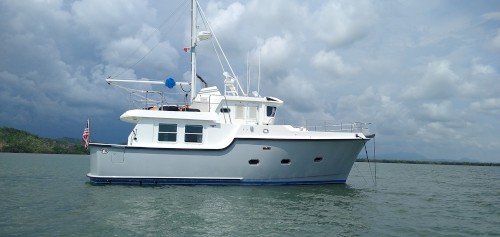
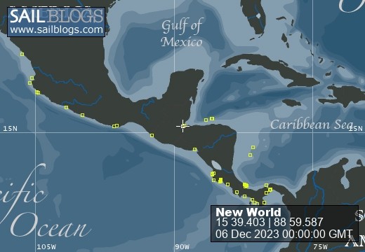
Grenville Channel
13 July 2022
by robert smith
We chose to stop at Curlew Bay, slightly of our planned track because the current in Grenville Channel was against us at four knots. That would have dropped our speed over the bottom to 3 knots or less and getting to a safe anchorage at 3 knots would have taken us into darkness. I call this bailing out, making a planned detour to prepare for a more favorable passage the next day.
Once anchored in Curlew Bay we started doing our homework. We read the guides, we checked Navionics and Ports and Passes, tide and current guide. At first it was very confusing, we drew pictures, we wrote down times and current speeds and directions. It was confusing because the sources talked about Flood currents happening at both ends at the same time meeting in the middle 4.5 miles from Lowes Inlet. The more we studied the more it seemed if we placed New World at the east end of the Channel at the correct time we could ride the west-bound Flood with a 2 -3 knot boost, arrive at just the right location when the west-bound Ebb started and ride it all the rest of the way with an equally favorable boost. Could we make that happen?
Back in southern New England waters there is a similar phenomenon. Travelling east from Block Island, if you time it correctly you could get a current ride going east to a point south of Buzzards Bay and as the current changed ride it all the way to the Cape Cod Canal and it worked in reverse as well. I had done this many times and the charts and tide books there were incredibly helpful with current arrows, times and the like. It made it simple to get it right. Out here, not so much. One current arrow in the 45 mile Channel. Ports and Passages gave us times from a distant location to add to time to Flood or time to Ebb at that mystical point about halfway through the Channel. Nothing about the time to start on the east end; that we had to use our best judgement. Time it wrong and a foul four knot current would make for a veery very long passage if we even would choose to continue. So we studied, check and re-check the timing at the only know point we had. I calculate the distance from our anchorage to the east entrance. We calculated the distances to several bail out anchorages just in case we were wrong in our calculations. We made a decision, anchor up a 6:00AM, travel the distance to the entrance to arrive at 7:00AM and then hope we were right.
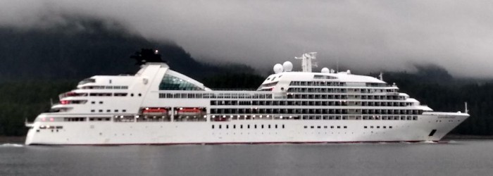
Timing to the entrance was spot on, however there was Ebb current against us, our boat speed over the bottom was just 6knots. Be patient, Bob. Slowly the GPS speed increased to 6.5 to 7.2 to 8.4 to 9.0, we were booking. We passed a cruise shipped heading east, several pleasure boats also going east and I began to wonder, what did they know we didn't? Actually I didn't care, we were trucking, heading for the mystical point down the line.
To make this story shorter, we pulled it off perfectly. At the designated point our speed began to slow and the west-bound Flood turned into a west-bound Ebb. Again slowly our speed return to the 8knot range. We had 7.5 to 8 knots all the rest of the way and as a result of our good fortune we cancelled our Plan A and continued on to where we are at Lawson Harbor. The guide says we can see the lights of Prince Rupert from here, we are that close. All-in-all a great day for the Smithies and New World.

Comments