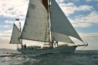
Dermot's NW Passage voyage on board Young Larry
23 September 2010 | Just left Nome
23 September 2010 | Just left Nome
17 September 2010 | Approaching Nome
12 September 2010 | Barrow
11 September 2010 | 25 miles east of Point Barrow
11 September 2010 | 25 miles east of Point Barrow
10 September 2010 | Beaufort Sea
09 September 2010 | Beaufort Sea
08 September 2010 | Approaching Demarcation Point
07 September 2010 | Herschel Island
06 September 2010 | Herschel Island
05 September 2010 | The rather splendidly named Beluga Bay- despite its absence of said whales so far
05 September 2010
04 September 2010
04 September 2010 | Tuktoyaktuk
03 September 2010 | Approaching Tuktoyaktuk
02 September 2010 | Franklin Bay
02 September 2010 | Franklin Bay
02 September 2010 | Franklin Bay
01 September 2010
A change of scene and scenery
24 August 2010 | Simpson Strait
Liz for Dermot
Took ages to do the washing in the Gjoa Haven Hotel last night. We were fabulously looked after by the very hard-working Newfoundland couple, Helena and Gerald, managing the hotel. We booked in for roast turkey supper, with the four of us tapping at our laptops trying to slurp up the limited internet access whilst the hotel's proper guests had dinner. The internet access was however frustratingly slow but we mustn't complain. I did try putting some extra photos up online at http://gallery.me.com/dermotor#100294 but the connection was so slow I'm not sure how effectively this worked. Also the blog-posting last night was done by me on the fly and I suspect less efficiently that when Liz does it.
The washing was taking so long that eventually Andrew had to go back to chat to a Finnish couple, Riitta and Pekka, on board their boat, Sarema. See their blog at http://www.northwestpassage2010.blogspot.com/ or http://www.sarema.fi/
They are sailing west to east, the opposite way to us, so it was most useful to share experiences as Gjoa Haven seems to be the usual crossing place. They have a dog on board that is of Portuguese origin and is a spitting image of my brother Dom's splendid and intelligent (but sexist and racist) dog Skellig.
Maire then also had to leave to welcome the local catholic priest on board, Fr Patrick, who despite his name is a French Canadian from Quebec. He loves the outdoors and is having to learn to how to use a rifle. He wasn't convinced he needed one but when he went off camping near one of the other communities he serves, the locals spotted ice bear prints outside his tent!
In the hotel's rather grandly titled 'board room' was also the young clerk to the circuit court that visits Gjoa Haven every three months. Mostly assault charges related to alcohol and drugs, despite the community being officially 'dry'. Up before the beak today, apparently, was the deputy mayor!
Clearly there are big contrasts here and in the other remote northern communities. On the one hand we made incredibly welcome in Gjoa Haven and saw clear evidence of a very strong community spirit and a pride in their Inuit traditions at the feast/dance and the flag raising ceremony. Beneath the surface there are clear tensions. There is not much employment around beyond the two stores, the hotel, the government office and the school. Certainly not enough to support the growing population especially as everything is SOOO expensive. Life up hear is heavily subsidised with welfare payments but I doubt that money goes far.
Eventually the four big loads of washing and drying was complete, but it was 11pm before Sibeal and I were back on board.
When we got onboard the wind had shifted to the north, which was an improvement on yesterday's NW head wind. The fog had come down however so the plan was for Andrew to survey the scene at 6am. If conditions were favourable he would wake the crew for an early departure towards the narrow, twisting Simpson Strait.
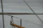
Fortunately they were, and we were underway, washing the clay of the anchor, by 6.30. Gjoa Haven had been an excellent stop for us, as well as Amundsen, who described it as the best harbour in the world. So much so that he spent two winters there, on the way to being the first person ever to sail the NW Passage. Seen from the sea (we had entered in the dark) it would seem that Amundsen did very well to have spotted the harbour as like everything along this coast it is pretty low, flat and featureless. Sailing out the harbour we passed the cruise ship, Clipper Adventurer.
Just before we entered the Simpson Strait we passed in the fog our third Canadian coast guard ship, the Sir Wilfrid Laurier. True to the form of their colleagues on the Terry Fox & the Henry Larsen, when we called them up on the VHF, the officer on watch was most chatty and helpful. Young Larry was on a lookout list that they receive at their daily morning briefing from the Canadian coordinating body, NORDREG. Nice to know that people are looking out for you. We do also update NORDREG with our passage plans so they would know if we are overdue.
Fortunately the fog lifted for the passage through the Simpson Strait. Andrew and I thoroughly enjoyed this little section of coastal navigation, comparing radar, visual and GPS fixes. Sibeal mostly humoured us with comments along the lines of "That's nice, dear" and wondered if Andrew would need to have a lie down as too much fun might get him too excited. By the end though, I think that even she was having to accept that the system worked well and that there are worse things in the world that we could get such simple pleasure from!
Most of the passage involved following transits formed by leading lines (or ranges as the locals call them). Essentially they have placed two small beacons which when lined up point to the route of safe water between the rocks. We would follow each segment for a mile or so before having to pick up the next transit. We also had a 1.5 knot tide pushing us through, though at times it would be running sideways to the line of the transit. It is a sometimes a bit tricky following the line when they are behind the helmsman. Young Larry also saw her first navigation buoys since leaving Ireland- they have a pretty much guaranteed chance of being shifter up here by ice.
We are now out of the Strait and heading almost due west in Storis Passage, bound for Cambridge Bay, about 200 miles away that should take us about 36 hours.
As well as the landscape changing, so has the birdlife. No more deep sea birds like fulmars, but geese and waders. In particular what I think are snow geese and white fronted geese.
We are now on an older Canadian chart that uses fathoms for depths and feet for heights. It is actually the most up-to-date one available (they are gradually switching to metric charts). All charts have their positions related to a 'datum' that tells you where to plot the latitude and longitude positions that a satnav gives you. This also varies between the metric and fathom charts (which mostly refer to a reassuringly modern 1927 datum). This chart hover has the caveat that it refers to an unknown datum and that satnav positions might be up to 0.5 nautical miles out of position. Most reassuring when there are a whole bunch of rock. In fact much of the area covered by the chart is just unsurveyed white space if one were to stay off the direct routes. There be dragons!
The washing was taking so long that eventually Andrew had to go back to chat to a Finnish couple, Riitta and Pekka, on board their boat, Sarema. See their blog at http://www.northwestpassage2010.blogspot.com/ or http://www.sarema.fi/
They are sailing west to east, the opposite way to us, so it was most useful to share experiences as Gjoa Haven seems to be the usual crossing place. They have a dog on board that is of Portuguese origin and is a spitting image of my brother Dom's splendid and intelligent (but sexist and racist) dog Skellig.
Maire then also had to leave to welcome the local catholic priest on board, Fr Patrick, who despite his name is a French Canadian from Quebec. He loves the outdoors and is having to learn to how to use a rifle. He wasn't convinced he needed one but when he went off camping near one of the other communities he serves, the locals spotted ice bear prints outside his tent!
In the hotel's rather grandly titled 'board room' was also the young clerk to the circuit court that visits Gjoa Haven every three months. Mostly assault charges related to alcohol and drugs, despite the community being officially 'dry'. Up before the beak today, apparently, was the deputy mayor!
Clearly there are big contrasts here and in the other remote northern communities. On the one hand we made incredibly welcome in Gjoa Haven and saw clear evidence of a very strong community spirit and a pride in their Inuit traditions at the feast/dance and the flag raising ceremony. Beneath the surface there are clear tensions. There is not much employment around beyond the two stores, the hotel, the government office and the school. Certainly not enough to support the growing population especially as everything is SOOO expensive. Life up hear is heavily subsidised with welfare payments but I doubt that money goes far.
Eventually the four big loads of washing and drying was complete, but it was 11pm before Sibeal and I were back on board.
When we got onboard the wind had shifted to the north, which was an improvement on yesterday's NW head wind. The fog had come down however so the plan was for Andrew to survey the scene at 6am. If conditions were favourable he would wake the crew for an early departure towards the narrow, twisting Simpson Strait.
Fortunately they were, and we were underway, washing the clay of the anchor, by 6.30. Gjoa Haven had been an excellent stop for us, as well as Amundsen, who described it as the best harbour in the world. So much so that he spent two winters there, on the way to being the first person ever to sail the NW Passage. Seen from the sea (we had entered in the dark) it would seem that Amundsen did very well to have spotted the harbour as like everything along this coast it is pretty low, flat and featureless. Sailing out the harbour we passed the cruise ship, Clipper Adventurer.
Just before we entered the Simpson Strait we passed in the fog our third Canadian coast guard ship, the Sir Wilfrid Laurier. True to the form of their colleagues on the Terry Fox & the Henry Larsen, when we called them up on the VHF, the officer on watch was most chatty and helpful. Young Larry was on a lookout list that they receive at their daily morning briefing from the Canadian coordinating body, NORDREG. Nice to know that people are looking out for you. We do also update NORDREG with our passage plans so they would know if we are overdue.
Fortunately the fog lifted for the passage through the Simpson Strait. Andrew and I thoroughly enjoyed this little section of coastal navigation, comparing radar, visual and GPS fixes. Sibeal mostly humoured us with comments along the lines of "That's nice, dear" and wondered if Andrew would need to have a lie down as too much fun might get him too excited. By the end though, I think that even she was having to accept that the system worked well and that there are worse things in the world that we could get such simple pleasure from!
Most of the passage involved following transits formed by leading lines (or ranges as the locals call them). Essentially they have placed two small beacons which when lined up point to the route of safe water between the rocks. We would follow each segment for a mile or so before having to pick up the next transit. We also had a 1.5 knot tide pushing us through, though at times it would be running sideways to the line of the transit. It is a sometimes a bit tricky following the line when they are behind the helmsman. Young Larry also saw her first navigation buoys since leaving Ireland- they have a pretty much guaranteed chance of being shifter up here by ice.
We are now out of the Strait and heading almost due west in Storis Passage, bound for Cambridge Bay, about 200 miles away that should take us about 36 hours.
As well as the landscape changing, so has the birdlife. No more deep sea birds like fulmars, but geese and waders. In particular what I think are snow geese and white fronted geese.
We are now on an older Canadian chart that uses fathoms for depths and feet for heights. It is actually the most up-to-date one available (they are gradually switching to metric charts). All charts have their positions related to a 'datum' that tells you where to plot the latitude and longitude positions that a satnav gives you. This also varies between the metric and fathom charts (which mostly refer to a reassuringly modern 1927 datum). This chart hover has the caveat that it refers to an unknown datum and that satnav positions might be up to 0.5 nautical miles out of position. Most reassuring when there are a whole bunch of rock. In fact much of the area covered by the chart is just unsurveyed white space if one were to stay off the direct routes. There be dragons!
Comments
| Vessel Name: | Young Larry |
Gallery not available