
Options
17 October 2012 | North Carolina
16 October 2012 | Near Elizabeth City, North Carolina
12 October 2012 | Dismal Swamp, VA-NC
07 October 2012 | Baltimore to Portsmouth, VA
29 August 2012 | Ptown to Edgartown
14 August 2012 | Portland, Maine
13 August 2012 | Freeport, Maine
09 August 2012 | Baltimore to Portsmouth, NH
05 July 2012
07 May 2012 | Cape Hatteras to Norfolk
04 May 2012 | East of Georgia?
03 May 2012 | Stuart, FL
06 January 2012
27 August 2011 | BWI Airport
24 August 2011
21 August 2011 | Now in Delaware City
20 August 2011 | Long Island Sound
13 August 2011 | Newport to Cuttyhunk to Vineyard Haven
13 August 2011 | BI, RI
07 August 2011 | Vineyard Haven, Martha's Vineyard
Stuart to Baltimore
03 May 2012 | Stuart, FL
David, warm and PC
Ahoy mateys! It's Thursday morning, May 3, 2012, sunrise in Stuart, FL. Two bridges to clear before we can head out to sea. We just waited 20 minutes for two trains to pass before the RR bridge could be raised; now waiting for the old Roosevelt bridge to open up for us. At 7 am, we are through the bridges with no more obstructions in our way. It will take us an hour and a half to motor downriver and through the pass to the ocean. Another half hour out to sea and we'll be on the Gulf Stream conveyer belt, which will likely add 2 knots to our speed.
There might be just enough wind to sail today, but more likely we'll run one engine to boost our speed. We'd like to average 8 knots (about 9.2 mph), which would get us to Cape Hatteras in 72 hours or so. The forecast for Sunday morning at Cape Hatteras is not good: 15 to 20 knots of wind right on the nose. Hatteras is one of the most dangerous capes in the U.S., a place where currents collide and storms tend to concentrate their power. It can make for treacherous conditions.
We will see what the actual conditions are as we get close. There are a couple of inlets where we can duck inshore before we get to Cape Hatteras. That would give us more protected conditions, away from the oceans swells. On the other hand, we would have to thread the needle in parts, going through some narrow channels. It can be kind of like driving a car down a liquid highway, with water sometimes flowing across your path and pushing you off the highway made invisible by the water. On the ocean, you can pick a spot and often head straight for it. The inland waterways are often circuitous, adding many extra miles to your trip. Taking the inside track to avoid Cape Hatteras will likely add 1-2 days to our journey.
I've got the satellite phone charged up with more minutes, after letting it lapse for the last year. They now have a plan where you can add minutes for a month at a time for a reasonable price, so I'll be talking to Brooke a couple of times a day to update her and get a weather update in return. That will be important as we approach Hatteras.
This will likely be my last blog for at least 72 hours, unless Brooke decides to do some updates in between. With us luck and don't forget to track our progress on-line. The easiest way is to click right under "Favorites" on the right-hand side of our Sail Blog page.
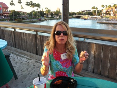
The photo is of Brooke at an RGA function in Orlando on Tuesday night, telling me not to take the picture. I thought she looked great!
David
There might be just enough wind to sail today, but more likely we'll run one engine to boost our speed. We'd like to average 8 knots (about 9.2 mph), which would get us to Cape Hatteras in 72 hours or so. The forecast for Sunday morning at Cape Hatteras is not good: 15 to 20 knots of wind right on the nose. Hatteras is one of the most dangerous capes in the U.S., a place where currents collide and storms tend to concentrate their power. It can make for treacherous conditions.
We will see what the actual conditions are as we get close. There are a couple of inlets where we can duck inshore before we get to Cape Hatteras. That would give us more protected conditions, away from the oceans swells. On the other hand, we would have to thread the needle in parts, going through some narrow channels. It can be kind of like driving a car down a liquid highway, with water sometimes flowing across your path and pushing you off the highway made invisible by the water. On the ocean, you can pick a spot and often head straight for it. The inland waterways are often circuitous, adding many extra miles to your trip. Taking the inside track to avoid Cape Hatteras will likely add 1-2 days to our journey.
I've got the satellite phone charged up with more minutes, after letting it lapse for the last year. They now have a plan where you can add minutes for a month at a time for a reasonable price, so I'll be talking to Brooke a couple of times a day to update her and get a weather update in return. That will be important as we approach Hatteras.
This will likely be my last blog for at least 72 hours, unless Brooke decides to do some updates in between. With us luck and don't forget to track our progress on-line. The easiest way is to click right under "Favorites" on the right-hand side of our Sail Blog page.
The photo is of Brooke at an RGA function in Orlando on Tuesday night, telling me not to take the picture. I thought she looked great!
David
Comments
| Vessel Name: | Options |
| Vessel Make/Model: | Admiral 40 |
| Hailing Port: | St. Louis, MO |
| Crew: | David and Brooke Atkinson |
| About: | David and Brooke reside in St. Louis and enjoy sailing (duh!), music, history and traveling. Brooke is a wonderful cook and David is an adequate guitarist. They signed up for an Admiral 38 in 2005. By waiting until 2008 for delivery, they were upgraded to the new Admiral 40. |
| Extra: |
Gallery not available
Options - SA to Carib
Who: David and Brooke Atkinson
Port: St. Louis, MO
See posts below
SailBlogs Friends

