Adventures of Orcinius
11 September 2015 | HOME - Vancouver WA
24 August 2015 | 46 11.4'N:123 51.4'W, Port of Astoria Marina
22 August 2015 | 46 42.0'N:132 09,4'W, 330 West of CR Bouy, Astoria
21 August 2015 | 46 41.8'N:136 13.8'W, 500 West of Astoria
20 August 2015 | 46 22.82'N:140 28.00'W, East end of High
20 August 2015 | 46 22.80'N:140 28.32'W, Middle of High Same as Fish
20 August 2015 | 46 22.79'N:140 28.57'W, Middle of High
20 August 2015 | 46 22.7'N:140 30.2'W, 675 Miles West of CR
20 August 2015 | 45 57.6'N:144 54.0'W, East End of the High
18 August 2015 | 44 38.2'N:147 57.0'W, 1000 NM to Astoria
18 August 2015 | 43 31.0'N:150 28.0'W, 1126 NM to Astoria
17 August 2015 | 41 40.1'N:153 00.1'W, 1200 miles West of Astoria
16 August 2015 | 39 30.1'N:154 53.1'W, West end of the North Pacific High
15 August 2015 | 37 34.5'N:156 00.0'W, 1011 North of Oahu
15 August 2015 | 37 04.5'N:156 23.0'W, 983 North of Oahu
14 August 2015 | 34 12.3'N:157 26.1'W, 800 North of Oahu
13 August 2015 | 31 50.0'N:158 06.5'W, 650 North of Oahu
12 August 2015 | 29 02.0'N:158 51.0'W, 330 North of Oahu
11 August 2015 | 26 32.0'N:158 59.0'W, 330 North of Oahu
09 August 2015 | 23 44.1'N:158 49.4'W, 140 N of Oahu
Viani Bay, Vanua Levu, Fiji
28 May 2014 | Viani Bay
We made it in yesterday after trying to chase down which reef pass we wanted to enter through. The frustration was quite high because the wind was up and the current running. The real challenge was when we zoomed in with our Raymarine Chartplotter with Navionics charts, the view went to S&*T. In this day and age it is a sad, sad state of professionalism to produce a chart that goes from fairly high quality geographics to block images when you zoom in to make a 100 meter wide pass. By the way, Raymarine and Navionics are not the least expensive methods for chart plotting so I would suspect they could try to do themselves proud to make a much better product. So as we motor sail up and down the straight looking for the info necessary to make a prudent decision on which pass and the route in, I chase down my laptop and fire up OpenCPN with the Google Earth interface. Thirty minutes go buy and my GE Cache won't come up to the correct resolution through the OpenCPN. Now I am really frustrated. I also could not find a way that looking at GE after picking a spot on the OCPN program chart to identify that spot on the GE window. It gave me a great picture but it was worthless to me because I had no clue to where we, the boat was with respect to the GE picture. Gave up and decided to do it the old fashion way. Visually.
So it was early afternoon but the wind was up and there was a chop and current running lateral to the pass. We decide on the Eastern pass as it showed to be much larger. We used the Raymarine chartplotter, two InavX apps on Ipads and the instrumented depth sounder and wormed our way into the pass and into Viani Bay.
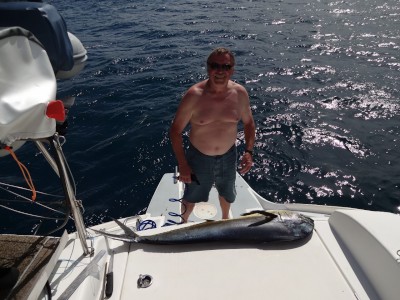
The good thing is while we were waiting to figure out which way we wanted to enter, we caught a 48" Dorado. We were only moving at about 2.5 knots when Walt just though the line was doing a zig zag behind the boat and Lisa said she thought there was a fish on it. So doing the prudent thing, I drug the fish in and gaffed it to put the lasoo on it's tail. She was quite mellow until I decided to remove the gaff. Then she started to flail about until I managed to get the gaff back in her gills and terminate her misery. In the process she got even with me by splattering blood all over the place, including me. We let her pass quietly and before heading to an anchor point I filet the sides and then cut all the extra meat off the bones to make ceveche for dinner. Earlier we had taken a slab of corned beef out of the freezer so after catching the fish we put the thawed beef back into the refer for another day.
We cooked up some cassava root in a foil pouch and made a lemon, garlic, caper and butter sauce with onions and yellow capsicum peppers as a layer over the bbq's dorado filets. The dinner meal was delicious. Had ceveche for appetizer and then again for lunch and still have some left over. Tonight we did the corned beef with cabbage, green beans and zucchini. Damned if that didn't turn out great also.
Enough for the food aspect, today we finally got the diving gear out. Set it all up and dove off the back of the boat as a FAM dive (re-familiarization with diving). None of us had been in the water with scuba gear on for over 1.5 years. Good thing because we managed to get the kinks worked out and we will do another tomorrow right around the boat. It was also a good thing because when we got down by the anchor, it was not set very well even though I snorkeled it when we came in after anchoring. Could not see it very well with snorkel gear and so when we were in scuba today it was quite obvious it was not set well. So we all got out of the water and made a couple maneuvers with the chain tight and then I went back into the water to see if that cured the problem. Not quite, so I dove back in and made a couple of adjustments and then put a retrieving buoy on it to make it more manageable. Reset and now I can sleep tonight, didn't last night so was the personal anchor alarm.
All for now because we are having a movie night. Hoping this one goes a little better than the last.
Comments
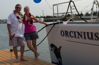
| Vessel Name: | ORCINIUS |
| Vessel Make/Model: | Lagoon 440 |
| Hailing Port: | Vancouver, Washington |
| Crew: | John LeDoux & Lisa Danger |
| About: | |
| Extra: | Lisa is the real captain. I have never been at the helm when docking or anchoring, she has a great touch to docking. |
| Home Page: | www.orcinius.com |
Gallery not available
Who: John LeDoux & Lisa Danger
Port: Vancouver, Washington