Voyages North
23 July 2023
21 August 2021
11 July 2021 | Posted in Seattle
16 May 2021
07 January 2021
10 April 2020 | Posted in Seattle
31 August 2019 | Posted at Port McNeill
31 August 2019
30 August 2019
30 August 2019 | Posted at Port MCNeill
13 August 2019 | Posted at Prince Rupert
13 August 2019 | Posted at Prince Rupert
03 August 2019 | Posted at Ketchikan
02 August 2019 | Posted at Metlakatla
02 August 2019 | posted in Metlakatla AK
22 July 2019 | Posted at Klawock/Craig
22 July 2019 | Posted at Klawock/Craig
09 July 2019 | Posted at Juneau
09 July 2019 | Posted at Juneau
27 June 2019
Foggust. Ward Channel to Blunden Harbour. August 15-18, 2012.
28 August 2012
Elsie Hulsizer
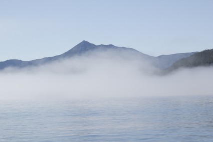
Photo: Fog in Fitz Hugh Sound.
“This is getting old,” said Steve, peering through the fog in a vain attempt to see Robinson Island at the entrance to Blunden Harbour. This was the fourth day of fog, the third day we had traveled in it. We were barreling south down Queen Charlotte Strait with a good wind behind us. And we couldn’t see where we were going.
On the West Coast of Vancouver Island, they call August Foggust. But we weren’t on the West Coast of Vancouver Island; we were in Queen Charlotte Straits. On our five previous August trips around Cape Caution and into Queen Charlotte Straits, we had had little fog. So when we woke up Wednesday morning in thick fog in a little cove off Ward Channel, I didn’t expect it to last. I should have realized that when the fog is so thick you can’t see rocks a few feet away, it’s not going to go away.
When we left that morning we could just barely see our way out of the cove.

Photo: Fog clearing in a cove off Ward Channel.
By the time we left the cove, we couldn’t see a thing. We had to rely on compass course, chart plotter, radar and our automatic fog horn to get us through. The fog horn let others know we were there, the compass course, chart plotter and radar told us where we were -- and what direction we needed to go. We crossed Hakai Pass and entered Fitz Hugh Sound. Half an hour later, the fog lifted and we could see across the Sound. Amazingly, as the fog cleared, the air was crystal clear.
The clear skies didn’t last. As we headed out past Cape Calvert to reach Smith Sound where we planned to anchor in Millbrook Cove, the west win, which allowed us to raise sail, pushed fog in. We sailed into Smith Sound in fog so thick the only signs of the rocks and islands we were passing were lines of white breakers at their bases.
The next day we woke again to thick fog. We waited until 10:00 am when the fog finally thinned enough to see our way out of the cove. But as soon as we cleared the entrance, we couldn’t see a thing.
Our radar and chart plotter gave us confidence in our position. We weren’t afraid of the rocks (besides, we couldn’t see them, which takes away the fear). What we were afraid of was the other boats. Our AIS (Automatic Identification for Ships) and radar showed a 60 ft motor vessel coming up our stern. Steve called it on the radio, told them we were there and incidentally mentioned we saw one other “target” going toward them on our radar. The response -- one word, “okay.” Half an hour later we watched as two radar spots (the motor vessel and the “target”) approached each other, merged into one, then separated again. They must have been very close. Then the motor vessel headed directly towards us, changing course only after a few minutes of holding our breath. It went by half a mile away and we never saw it.
We made it into Skull Cove at 2:30 that afternoon. “Let’s take a day off,” I suggested to Steve. He agreed. The next day we watched the fog swirl around the islands in the cove and listened to red throated loons quack and wail. When the fog thinned in the afternoon, we took our kayaks across a channel and through a maze of islands called Murray Labyrinth. I had grown to think of Skull Cove as merely a stop on the way to Port McNeil but it’s a destination too.

Photo: Steve kayaking through Murray Labyrinth
I thought the fog had ended when it cleared by 8 o’clock the next morning, but by early afternoon we were sailing through fog again - with a strong wind behind us. We peered anxiously for the entrance to Blunden Harbour. The fog lifted and we sailed through, tacking back and forth among the rocks and other boats to reach an anchorage. As I dropped the anchor, a voice growled from the next boat, a small cutter, “Stop sailing, you’re making the rest of us look incompetent.”
The next day, the fog really gone, we sat in the cutter’s cockpit with our new friends. A distant rumbling traveled across the water. A few minutes later, the rumbling grew louder. Then we saw lightning flash and the rumbling became loud crashes. We counted seconds between flashes: 15, 8, 5, 0! I looked at Osprey only a few yards away, but we didn’t dare get in the dinghy. Rain came down in sheets and we huddled under the dodger and listened and watched.
When it was over, I decided I preferred fog.
“This is getting old,” said Steve, peering through the fog in a vain attempt to see Robinson Island at the entrance to Blunden Harbour. This was the fourth day of fog, the third day we had traveled in it. We were barreling south down Queen Charlotte Strait with a good wind behind us. And we couldn’t see where we were going.
On the West Coast of Vancouver Island, they call August Foggust. But we weren’t on the West Coast of Vancouver Island; we were in Queen Charlotte Straits. On our five previous August trips around Cape Caution and into Queen Charlotte Straits, we had had little fog. So when we woke up Wednesday morning in thick fog in a little cove off Ward Channel, I didn’t expect it to last. I should have realized that when the fog is so thick you can’t see rocks a few feet away, it’s not going to go away.
When we left that morning we could just barely see our way out of the cove.
Photo: Fog clearing in a cove off Ward Channel.
By the time we left the cove, we couldn’t see a thing. We had to rely on compass course, chart plotter, radar and our automatic fog horn to get us through. The fog horn let others know we were there, the compass course, chart plotter and radar told us where we were -- and what direction we needed to go. We crossed Hakai Pass and entered Fitz Hugh Sound. Half an hour later, the fog lifted and we could see across the Sound. Amazingly, as the fog cleared, the air was crystal clear.
The clear skies didn’t last. As we headed out past Cape Calvert to reach Smith Sound where we planned to anchor in Millbrook Cove, the west win, which allowed us to raise sail, pushed fog in. We sailed into Smith Sound in fog so thick the only signs of the rocks and islands we were passing were lines of white breakers at their bases.
The next day we woke again to thick fog. We waited until 10:00 am when the fog finally thinned enough to see our way out of the cove. But as soon as we cleared the entrance, we couldn’t see a thing.
Our radar and chart plotter gave us confidence in our position. We weren’t afraid of the rocks (besides, we couldn’t see them, which takes away the fear). What we were afraid of was the other boats. Our AIS (Automatic Identification for Ships) and radar showed a 60 ft motor vessel coming up our stern. Steve called it on the radio, told them we were there and incidentally mentioned we saw one other “target” going toward them on our radar. The response -- one word, “okay.” Half an hour later we watched as two radar spots (the motor vessel and the “target”) approached each other, merged into one, then separated again. They must have been very close. Then the motor vessel headed directly towards us, changing course only after a few minutes of holding our breath. It went by half a mile away and we never saw it.
We made it into Skull Cove at 2:30 that afternoon. “Let’s take a day off,” I suggested to Steve. He agreed. The next day we watched the fog swirl around the islands in the cove and listened to red throated loons quack and wail. When the fog thinned in the afternoon, we took our kayaks across a channel and through a maze of islands called Murray Labyrinth. I had grown to think of Skull Cove as merely a stop on the way to Port McNeil but it’s a destination too.
Photo: Steve kayaking through Murray Labyrinth
I thought the fog had ended when it cleared by 8 o’clock the next morning, but by early afternoon we were sailing through fog again - with a strong wind behind us. We peered anxiously for the entrance to Blunden Harbour. The fog lifted and we sailed through, tacking back and forth among the rocks and other boats to reach an anchorage. As I dropped the anchor, a voice growled from the next boat, a small cutter, “Stop sailing, you’re making the rest of us look incompetent.”
The next day, the fog really gone, we sat in the cutter’s cockpit with our new friends. A distant rumbling traveled across the water. A few minutes later, the rumbling grew louder. Then we saw lightning flash and the rumbling became loud crashes. We counted seconds between flashes: 15, 8, 5, 0! I looked at Osprey only a few yards away, but we didn’t dare get in the dinghy. Rain came down in sheets and we huddled under the dodger and listened and watched.
When it was over, I decided I preferred fog.
Comments
| Vessel Name: | Osprey |
| Vessel Make/Model: | Annapolis 44 sloop |
| Hailing Port: | Seattle |
| Crew: | Steve and Elsie Hulsizer (author of Glaciers, Bears and Totems and Voyages to Windward) |
| About: | |
| Extra: |
Osprey's Photos - Main
No items in this gallery.
Voyages North on SV Osprey
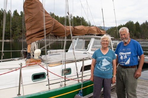
Who: Steve and Elsie Hulsizer (author of Glaciers, Bears and Totems and Voyages to Windward)
Port: Seattle
SailBlogs Friends

