Voyages North
23 July 2023
21 August 2021
11 July 2021 | Posted in Seattle
16 May 2021
07 January 2021
10 April 2020 | Posted in Seattle
31 August 2019 | Posted at Port McNeill
31 August 2019
30 August 2019
30 August 2019 | Posted at Port MCNeill
13 August 2019 | Posted at Prince Rupert
13 August 2019 | Posted at Prince Rupert
03 August 2019 | Posted at Ketchikan
02 August 2019 | Posted at Metlakatla
02 August 2019 | posted in Metlakatla AK
22 July 2019 | Posted at Klawock/Craig
22 July 2019 | Posted at Klawock/Craig
09 July 2019 | Posted at Juneau
09 July 2019 | Posted at Juneau
27 June 2019
Ahousaht Territory. July 10, 2016
29 July 2016 | Posted at Hakkai, Fitz Hugh Sound
Elsie Hulsizer
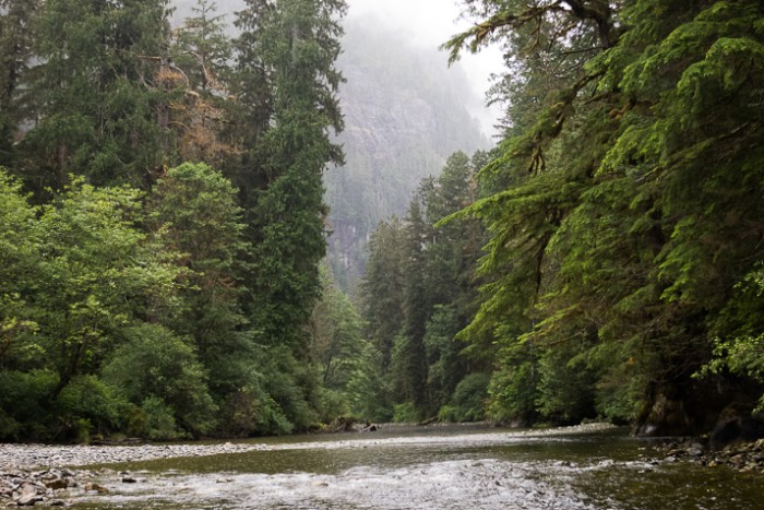
Photo: Watta Creek in Bacchante Bay. Ahousaht Territory?
We were weaving our way through the maze of rocks in Sulphur Passage between Millar Channel and Shelter Inlet, when I looked back and saw a small yellow powerboat following us. I didn't think anything of it; it was keeping its distance. But when we exited the Passage and started to turn starboard toward Bacchante Bay, it too turned right, forcing us to turn farther right to stay out of their way. Odd behavior for a small powerboat, most of which would have just speeded up and passed us. Watching it, I felt a prick of uneasiness.
As the boat approached us, I saw its name, Ahousat Guardian, then, noticed its occupants, two young men in blue uniforms. One of the men held up a radio, but after some confusion trying to match stations (they were on channel 65, not a normal calling channel), they came closer. "Are you going to anchor in Bacchante Bay?" the man asked, pointing up Shelter Inlet.
"Yes we are," Steve answered.
"You need a permit from us," the man said, holding up a receipt book. "Bacchante Bay is Ahousat Territory."
I was incredulous. "It's part of Strathcona Provincial Park."
"It's something we just started this year. You need a permit to anchor or camp in Ahousat Territory, anywhere between Ahousat and Hesquiat."
We knew Canada had never signed treaties with the First Nations in British Columbia and were trying to rectify that with negotiations. A few Nations had settled, but most had not. Could this be something that had come out of the treaty negotiations? Because we don't live in Canada, it would have been easy to miss news about it. Reluctantly, we agreed to pay the $10 per person per night. In return, we got a paper permit with a map showing a large area from Hesquiat to Ahousat labeled Ahousaht Sound (a name not shown on the chart). The permit noted that "the fees collected support the Ahousaht Chiefs and their efforts to manage their land and resources for the sustainable enjoyment and benefit of all living beings since the beginning of time and into the unforeseeable future."
We continued on into Bacchante Bay and anchored off the marsh just as the rain started. Despite the rain, we took the dinghy up Watta Creek, crossing the marsh and following the creek into a deep pool where we could look upstream to tall spruce. Blueberry bushes hung over the water and raindrops stippled the water with bubbles. It was beautiful, even in the rain, probably worth $20 a night. But the incident made us feel as if we had been scammed, ruining some of our enjoyment in the beauty.
The next day in Hot Springs Cove, we learned more. Thanks to good cell service, I went online and googled "Ahousat Guardian" and found a website stating that "the Ahousahts have started a Guardian Program to promote economic development within their territory. They are asking visitors to purchase camping permits for their stay within their territory." The website makes it sound voluntary; the men in the yellow boat made it sound mandatory. We also learned more from Shaun, the innkeeper on the floating hotel, the Innchanter. Shaun told us the program was controversial; with even some Ahousahts saying it was a scam.
What I haven't learned is what, if any, authority the Ahousahts have to require permits in the Provincial Park and what would happen if someone refused to pay. The Provincial Parks website says nothing about a fee in Bacchante Bay, nor does it acknowledge joint management. The Queen Cove band has started something similar, charging $5 a night to anchor in Queen Cove, even though the cove itself is not in their reserve. The Mowachats at Friendly Cove have charged a landing fee for years, but that has always seemed reasonable to me; it's their reserve and they maintain the trails and the historic church with its stained glass windows and carvings.
Finding the answers to my questions will have to wait until we're back in civilization. More research is required than I can do with the slow internet connections we have here.
I know the situation is complicated. BC First Nations in BC have gotten a bad deal to date. They were given only postage stamp-sized reserves - so small the total number of acreage in reserves on Vancouver Island is roughly the size of the Makah Reservation in Washington State. With such small reserves they can't protect their fish runs and the watersheds that support them. As a result of logging and overfishing the runs are only a small percentage of their original size in an area that is still wilderness.
I hope they figure it out. I'm willing to pay fees where appropriate. But their manner of approaching us and the amount they charged - far in excess of a fee I might expect to pay in a state or provincial park- made me feel I was being scammed. One Canadian boater we told about the fees was furious and determined not to pay. The long term consequence may be that fewer boaters will visit this part of the coast.
Comments
| Vessel Name: | Osprey |
| Vessel Make/Model: | Annapolis 44 sloop |
| Hailing Port: | Seattle |
| Crew: | Steve and Elsie Hulsizer (author of Glaciers, Bears and Totems and Voyages to Windward) |
| About: | |
| Extra: |
Osprey's Photos - Main
No items in this gallery.
Voyages North on SV Osprey
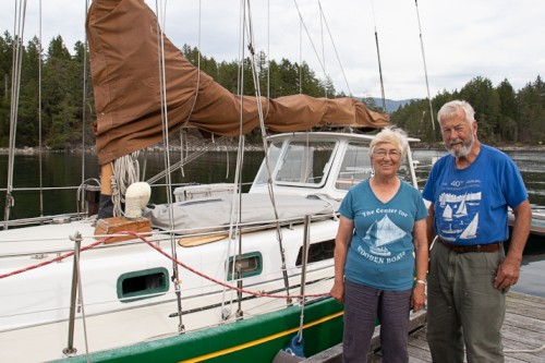
Who: Steve and Elsie Hulsizer (author of Glaciers, Bears and Totems and Voyages to Windward)
Port: Seattle
SailBlogs Friends

