Voyages North
23 July 2023
21 August 2021
11 July 2021 | Posted in Seattle
16 May 2021
07 January 2021
10 April 2020 | Posted in Seattle
31 August 2019 | Posted at Port McNeill
31 August 2019
30 August 2019
30 August 2019 | Posted at Port MCNeill
13 August 2019 | Posted at Prince Rupert
13 August 2019 | Posted at Prince Rupert
03 August 2019 | Posted at Ketchikan
02 August 2019 | Posted at Metlakatla
02 August 2019 | posted in Metlakatla AK
22 July 2019 | Posted at Klawock/Craig
22 July 2019 | Posted at Klawock/Craig
09 July 2019 | Posted at Juneau
09 July 2019 | Posted at Juneau
27 June 2019
Fords Terror: A Convenient Anchorage
11 July 2021 | Posted in Seattle
Elsie Hulsizer
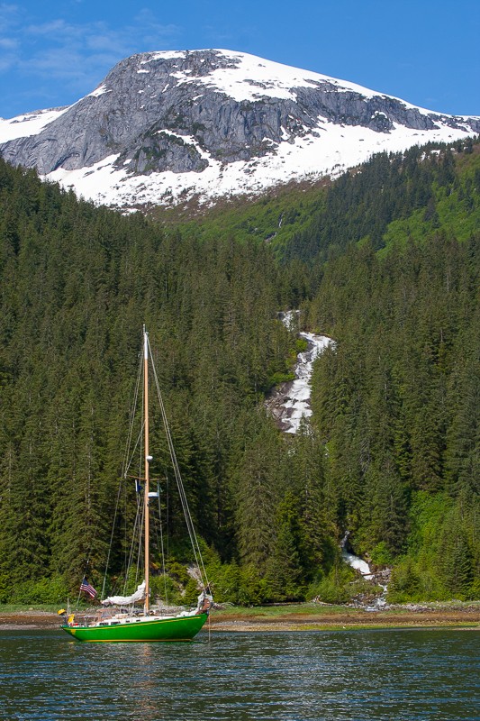
Photo: Osprey anchored in the West Arm of Fords Terror
In April 2013, I wrote an article in 48 North titled Braving the Narrows at Fords Terror. The next time we approached its entrance, we were surprised to see several boats ahead of us waiting for the tide. During previous trips we had seen at most one other boat each time. Concerned that the boaters might not know the safe way to enter, Steve radioed one of them and inquired whether they knew how to get in. "Well, I do have a magazine article about it," the skipper replied. With a full page photo of Osprey anchored in the West Arm of the inlet in the article, he obviously had recognized Osprey. I have since wondered, somewhat guiltily, if my article contributed to an increase in the number of boats going through.
The article is no longer available on the 48 North website. This blog is intended to provide the navigational information it contained. Most of the rest of that story was taken from my book Glaciers, Bears and Totems.
The 2021 edition of the Waggoner Cruising Guide states that there are no convenient anchorages in Endicott Arm, describing Fords Terror, halfway up the inlet, as remote, seldom visited and poorly charted.
I take issue with the characterization of Fords Terror as inconvenient. It's ideally situated for anchoring either the night before or after a trip to Dawes Glacier. And in my opinion, Fords Terror is one of the most spectacular anchorages in Southeast Alaska. It makes a trip up Endicott truly memorable. And although Fords Terror has a challenging entrance with uncharted rocks and no published tide tables, with sufficient local knowledge it's possible to make a trip there safely. And more boats are making it into Fords Terror every year.
In the Third edition of Exploring Southeast Alaska: Dixon Entrance to Skagway, Don Douglass and Reanne Hemingway-Douglas provide a sketch of the Fords Terror entrance and its outer basin. Both the sketch and the U.S. G.S. Survey Map for the Sumdum Quadrangle show more detail than the navigational chart including the locations of shoals and rocks. The Douglasses estimated that the entrance carries 8ft at zero tide and concluded that shallow-draft boats do not have to limit their transit to high-water slack. (The Douglasses successfully entered at low-water slack.) With our 6ft draft keel, we enter only at high-water slack.
There's also a useful trick for entering Fords Terror first reported by Linda Lewis, owner of Private Boating Instruction LLC, in a blog post. Captain Lewis recommended first locating the multi-stream waterfall on the west wall of the outer anchorage, putting your stern on that waterfall, then heading 290 magnetic to the entrance. That course would take a boat into the entrance between the two shoals.
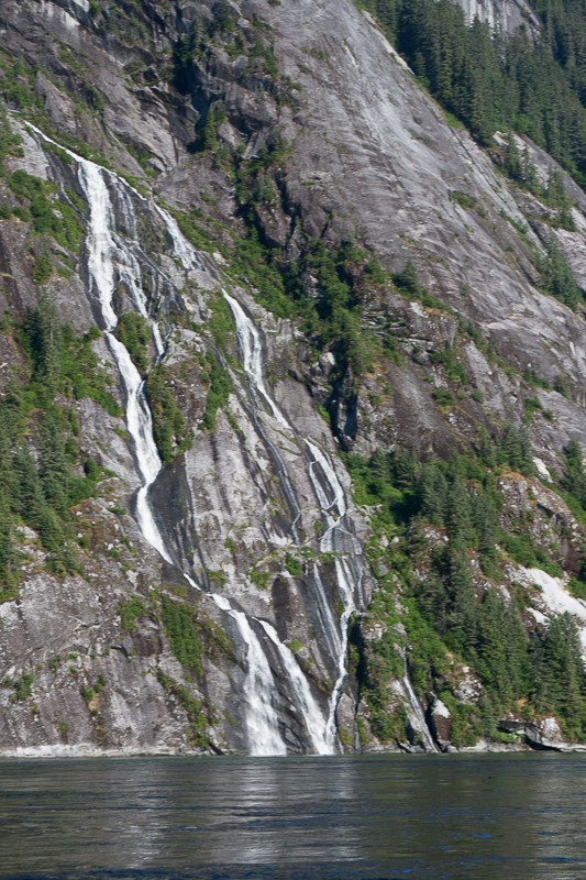
Photo: Multi-stream waterfall for entering Fords Terror
Changes in magnetic variation can alter a compass course over time and enough time has passed since Captain Lewis posted her blog (no longer online) to change the compass course by a few degrees. To deal with this, Steve developed the procedure of setting our course by steering toward the entrance itself from the waterfall, marking our compass course, then following that course into the entrance.
We learned another valuable piece of local knowledge from the tour boat Island Spirit. They enter or leave at 25 minutes after high water at Juneau.
If you are fortunate to arrive outside Fords Terror during low tide, you can observe the rocks and shoals while waiting for the tide to rise. That way, you will not only be able to recognize the entrance, but be properly terrified as you approach it.
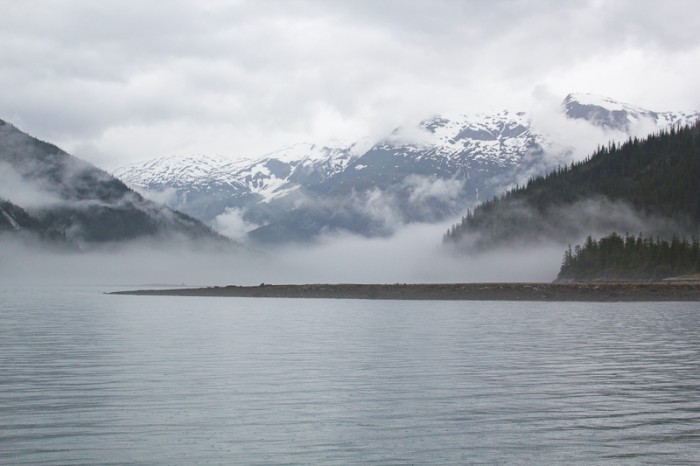
Photo: Fords Terror at Low Tide
In April 2013, I wrote an article in 48 North titled Braving the Narrows at Fords Terror. The next time we approached its entrance, we were surprised to see several boats ahead of us waiting for the tide. During previous trips we had seen at most one other boat each time. Concerned that the boaters might not know the safe way to enter, Steve radioed one of them and inquired whether they knew how to get in. "Well, I do have a magazine article about it," the skipper replied. With a full page photo of Osprey anchored in the West Arm of the inlet in the article, he obviously had recognized Osprey. I have since wondered, somewhat guiltily, if my article contributed to an increase in the number of boats going through.
The article is no longer available on the 48 North website. This blog is intended to provide the navigational information it contained. Most of the rest of that story was taken from my book Glaciers, Bears and Totems.
The 2021 edition of the Waggoner Cruising Guide states that there are no convenient anchorages in Endicott Arm, describing Fords Terror, halfway up the inlet, as remote, seldom visited and poorly charted.
I take issue with the characterization of Fords Terror as inconvenient. It's ideally situated for anchoring either the night before or after a trip to Dawes Glacier. And in my opinion, Fords Terror is one of the most spectacular anchorages in Southeast Alaska. It makes a trip up Endicott truly memorable. And although Fords Terror has a challenging entrance with uncharted rocks and no published tide tables, with sufficient local knowledge it's possible to make a trip there safely. And more boats are making it into Fords Terror every year.
In the Third edition of Exploring Southeast Alaska: Dixon Entrance to Skagway, Don Douglass and Reanne Hemingway-Douglas provide a sketch of the Fords Terror entrance and its outer basin. Both the sketch and the U.S. G.S. Survey Map for the Sumdum Quadrangle show more detail than the navigational chart including the locations of shoals and rocks. The Douglasses estimated that the entrance carries 8ft at zero tide and concluded that shallow-draft boats do not have to limit their transit to high-water slack. (The Douglasses successfully entered at low-water slack.) With our 6ft draft keel, we enter only at high-water slack.
There's also a useful trick for entering Fords Terror first reported by Linda Lewis, owner of Private Boating Instruction LLC, in a blog post. Captain Lewis recommended first locating the multi-stream waterfall on the west wall of the outer anchorage, putting your stern on that waterfall, then heading 290 magnetic to the entrance. That course would take a boat into the entrance between the two shoals.
Photo: Multi-stream waterfall for entering Fords Terror
Changes in magnetic variation can alter a compass course over time and enough time has passed since Captain Lewis posted her blog (no longer online) to change the compass course by a few degrees. To deal with this, Steve developed the procedure of setting our course by steering toward the entrance itself from the waterfall, marking our compass course, then following that course into the entrance.
We learned another valuable piece of local knowledge from the tour boat Island Spirit. They enter or leave at 25 minutes after high water at Juneau.
If you are fortunate to arrive outside Fords Terror during low tide, you can observe the rocks and shoals while waiting for the tide to rise. That way, you will not only be able to recognize the entrance, but be properly terrified as you approach it.
Photo: Fords Terror at Low Tide
Comments
| Vessel Name: | Osprey |
| Vessel Make/Model: | Annapolis 44 sloop |
| Hailing Port: | Seattle |
| Crew: | Steve and Elsie Hulsizer (author of Glaciers, Bears and Totems and Voyages to Windward) |
| About: | |
| Extra: |
Osprey's Photos - Main
No items in this gallery.
Voyages North on SV Osprey
Who: Steve and Elsie Hulsizer (author of Glaciers, Bears and Totems and Voyages to Windward)
Port: Seattle
SailBlogs Friends

