
Papillon Sails
27 June 2008 | 43.5 S 173 E
27 June 2008 | 45 S 167 E
27 June 2008 | 41 30 S 174 30 E
27 June 2008 | 35 S 174 E
27 June 2008 | Whangarei, 35 43S 174 19 E
26 June 2008 | 20 S 174 W
26 June 2008 | 19 03.376 S 169 55.532W
26 June 2008 | 21S 159 W
NZ in 17 Days, Part 4
27 June 2008 | 43.5 S 173 E
Julia
Christchurch made for a pleasant urban stop after so much nature. Christchurch was founded by Anglicans who wanted a little bit of England in NZ. The cathedral is beautiful, and built very much in the style of grand European cathedrals. The public gardens were beautiful, and the museum had the best Maori artwork we'd seen to date.
North of Christchurch is Kaikoura, the home of the South Island's famous crayfish (rock lobster). We headed there looking for a lobster dinner, but were put off by the $90/6 oz tail price! And that's without shipping! Even at roadside stands where fishwives sold their husband's catch the asking price was $40 for a 6 ounce lobster tail. We smiled, thought of the sweet $3.00 Mexican lobsters, and drove on. That's the nice part about cruising...there's always another treat to be found where the wind blows you.
The Marlborough wine country was our next destination as we closed the loop on the South Island. Allen and Joyce guided us to several wineries, including their former abode Te Ware Ra, for excellent wine. We joined them and the folks from the yacht Magnum for a delicious dinner aboard Sojourner.
Back to the North Island, with three days of vacation to go! Next stop: Napier on the East Coast. Napier is known as the seat of the Hawkes Bay wine region, and for its own art deco architecture. The weekend we were there, the town was full of horse people; there for a BIG annual horse show. Unfortunately, tickets were sold out well in advance---as were most hotel rooms. We were lucky to find a room in a B&B near downtown. The buildings were beautiful, but our vote for best art deco would go to Wanganui. The wines of Hawkes Bay are different from those of Marlborough:"more Pinots and Cabs. Our "find" was Crab Farm on the northern border of Hawkes Bay. Their reds were some of the best we've had in NZ.
We crossed back to the central North Island and Taupo. Lake Taupo, at 600 sq km, is the largest of NZ's lakes. It's actually the crater of a volcano that was created in the explosion of all explosions about 26,000 years ago, that produced 800 cubic km of ash (Mt. St. Helens produced 3 cubic km). Mt. Taupo exploded again for a week in 181 AD, and accounts of spectacular sunsets and darkened skies were recorded in China and Rome! In recent times, Mt. Taupo has been quiet, and the lake, which was stocked with American trout in the 1800's, is the site of one of the world's largest trout fishing tournaments.
About 90 km north of Lake Taupo is Rotorua, NZ's hot springs (picture). The entire band of land from Mt. Ruapehu to White Island (in the Bay of Plenty) is volcanic, and the earth's mantle heats groundwater to steaming from Tongariro National Park northward. Rotorua was considered sacred by the Maori. Whites came in the 1870's as tourists to see the famed Pink and White Terraces, formed by silica deposits from the volcanic activity in the area. Some considered the terraces the eighth wonder of the world. Tourists departed from Te Wairoa, a Maori village on Lake Tarawera to visit the terraces. On May 31, 1886, a boat load of tourists guided by the principal terrace guide Sophia Hinerangi saw a phantom ceremonial Maori canoe of a type long out of use gliding across the lake. Everyone, white or native, saw it. The Maoris saw the canoe as a bad omen. Within two weeks Mt Tarawera exploded. In five hours 1500 sq km were destroyed, including three Mairoi villages and the Pink and White Terraces. One hundred fifty three people were killed.
The eruption of Mt. Tarawera did not long dissuade people from coming to Rotorua to "take the waters" as cures for all sorts of diseases. The government of NZ established a beautiful spa there in 1908 that drew patients from as far as India and China. The groundwater is heated by magma that rises to within 80 km of the earth's surface. Today, the spa and surrounding buildings are a museum commemorating Rotorua's past. Of course, it is still possible to have spa treatments at various places around town, and each hotel has a hot spring bath on site for guests. (In fact, so many homes and businesses tapped into the thermal waters that water levels began to fall. Strict zoning was enforced to limit the amount of water that could be taken from under the city, lest it collapse.) The hard part about enjoying Rotorua is the sulfur smell, which permeates everything. There are numerous attractions around town that feature geysers and colorful pools. The mud around the steam vents houses plants and bacteria that are specially adapted to living at temperatures >105 F (40 C). It's interesting that at just a few degrees above the body temperature of humans, organisms on our planet begin to die off.
Continuing north to the Coromandel Peninsula, we returned to gold country. At the Karangahake Gorge we explored old mining tunnels. Miners here dug miles of tunnels on 14 levels between 1890 and 1920. 3.5 million ounces of gold and silver were extracted from Mt. Karangahake. The mine had its own battery for pulverizing the stone, and chemical baths for separating the metal from rock. On site smelters turned the raw silver and gold into ingots for transport to market. Today, the site is tree covered with trails and tunnels leading through the old mining area. Foundations and scrap metal poke out of the undergrowth, and signs explain the process.
We skirted the Frith of Thames, shot up through Auckland, and back to Whangarei. Papillon looked pretty good to us after 17 days and 3000 km of touring NZ. There was much that we missed, and it would be a treat to come back with no worries but to explore more of this beautiful land. However, other shores beckon, and our plan is to head to Fiji on June 30.
NZ in 17 Days, Part 3
27 June 2008 | 45 S 167 E
Julia
The southwest corner of the South Island is Fiordland National Park, a World Heritage area, and the largest of NZ's national parks. Fiordland was discovered in 1773 by Captain Cook. His crew began mapping the area and wrote about the whales, seals, and wild life in the area. They also incorrectly named many of the fiords "sounds." Sounds are river valleys that flood because the land below them sinks. Fiords are U-shaped valleys cut by glaciers. NZ's SW coast is glacial cut. Fourteen major fiords cut in from the coast within the park. The area receives an average rainfall of 6 meters/year, and couples lush foliage with incredible waterfalls.
The towns of TeAnau and Manapouri sit on lakes of the same names and serve as bases for the tourists visiting the area. Lake TeAnau was cut by a glacier, and is the second largest lake in NZ. It is 53 km long, 10 km wide, and 417 km deep. The 119 km road to Milford Sound begins on Lake TeAnau's eastern shore. It winds through alpine meadows, native bush (aka woods), and an area of sheer rock around the Homer Tunnel before descending to the "town" of Milford (which is really just the docks, restaurant, and parking lot for the tour buses and cruise ships). The night before and the morning we drove to Milford rain fell like a waterfall. (In fact, the night before our trip it rained so hard that the roof in a store we were in in TeAnau failed and the store flooded. We and a few other tourists moved thousands of dollars worth of merchandise away from the flood waters streaming down the walls!) We'd been warned that rain was a big part of the Fiordland experience, so we donned slickers and headed out. About the time we arrived at Milford, the rain stopped, the clouds parted, and the sun shined. We embarked on a Real Journeys power catamaran for a tour of 22 km long Milford Sound. Everywhere we looked there were awesome waterfalls: our timing was perfect! The mountains lining the fiord were snow and glacier topped, with green forest clinging to their sides. In many areas there were long vertical patches cleared of trees. We were told that the soil is so thin that if a tree topples, it will start an avalanche that will strip other growth for some distance, leaving a scar down the slope. It may take 40 years for trees to re-grow! The boat navigated the fiord to the opening to the Tasman Sea, then turned about for the trip back. Little had we realized the wind was whistling down the fiord, for the return headwinds were in the 25 knot range!
Monday's trip to Doubtful Sound was totally different. We started with a boat ride across Lake Manapouri. It's NZ's third largest lake, and a slightly little sister to TeAnau. At the foot of the lake is the West Arm power station. In the 1960's a kilometer deep tunnel was bored through solid rock to make a chute for water to travel. We traveled down a curving tunnel in the huge Real Journey's bus to see the power plant. (The road down, built by Americans, is the only right-hand drive road in NZ!) At the base is a set of turbines that provide 10% of NZ's power generation. The water exiting the turbines climbs up a ways to an outlet that feeds Doubtful Sound. The power is sent to an aluminum smelter further south, with any excess going to the NZ grid. The levels of Lake Manapour and Lake TeAnau are controlled through careful management of the water supply to the turbines to ensure that these NZ treasures are maintained.
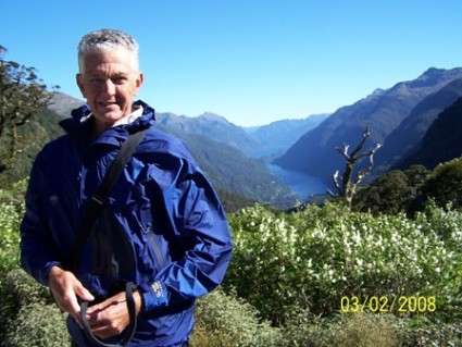
From West Arm power station we traveled across Wilmot Pass (picture) with its great view of Doubtful Sound, then down to the boats in the sound itself. Doubtful Sound is deeper than any of the other fiords, at 421 meters, and is the longest at 40 km. In 1770, Captain Cook bypassed it, calling it Doubtful Harbor because he doubted there was enough wind inside to pilot his square rigger out. No problems this day, as the wind once again channeled through the fiords.
Although the land of Fiordland is protected by the National Park System, the marine life is not. Through a quirk of legislation, wildlife was protected only to the water line. In all the fiords, public fishing and shell fishing is legal. Thousands of lobsters are taken each year from Doubtful Sound. Only a very small area, a few hundred meters on a side, is designated a marine reserve in Doubtful Sound. Nonetheless, the marine life is rich and varied. Dolphins inhabit the sound year around; seals and penguins make seasonal visits; black coral grows in the depths; and colorful fish abound. Dive excursions run daily and can be thrilling for those willing to brave the cool waters.
Restaurants in TeAnau featured the ubiquitous NZ lamb and farmed deer. Driving to TeAnau we saw large pastures filled with huge herds of deer. As NZ had no native mammals, we questioned the origin of the deer. They were brought in by Europeans to be hunted, however they had no natural enemies and deer are kind of like big rabbits....Within a few generations, they were taking over Fiordland, munching their way through large tracts of native bush. The government realized that the deer problem had to be solved, so they authorized hunters to hunt them from helicopters. After the deer were shot, the choppers landed to recover the carcasses. As the hunters became more proficient and the deer populations waned, the hunters realized they were losing a valuable source of meat. A few enterprising individuals decided to dart the deer, then use the choppers to haul them out to farms. It wasn't unusual to see 4-5 live deer hanging from a helicopter. The domestic herds we see today are offspring of the flying deer (New Zealand's answer to Santa's raindeer???).
Our next stop was the east coast town of Oamaru. It had an interesting history, as it was a banking town during the gold rush days. Through the 1930's it did well, and the town invested in beautiful stone buildings that showed the best of architecture from the 20's and 30's. Then, disaster hit in the form of dwindling gold discoveries and the world wide recession. Business dried up and people moved away. In fact, just about everyone moved away, just locking the buildings and leaving them to fend for themselves. Forty years later, people moved back and realized the treasure they had in the architecture of the town. Now, a thriving seaport community, Oamaru displays her heritage with pride. It was fun checking out the old buildings, and Oamaru's other most famous attraction: the yellow eyed penguins.
NZ is home to three types of penguins: the blue eyed, yellow eyed, and crested penguins. Both blue-eyed and yellow-eyed come ashore in Oamaru, but the yellow eyed ones are accessible at dusk from a seaside park. Intrepid adventurers that we are, we drove out to the trail and hiked up the gravel lined walk to an overlook. There, 80 feet below us on the seashore was a lone yellow eyed penguin. S/he'd come ashore and was waiting patiently for friends to come out of the sea. Waiting. Waiting. Waiting. As were we. Other tourists pointed HUGE telephoto camera lenses at down at our lone friend. Then, he moved...about � turn to the right! And waited. We hope his friends came, but not while we were there.
Yellow eyed penguins nest between Oamaru and Stewart Island (very southern tip of NZ) between August and September. The hatchlings generally leave the nest, totally independent, in February. They travel as far north as Cook Straight before returning at 2 years of age to their home area to breed. They travel as much as 40 km out to sea, and dive 120 meters to hunt. They, like the other two types, are becoming increasingly rare as their habitat is threatened by humans.
The towns of TeAnau and Manapouri sit on lakes of the same names and serve as bases for the tourists visiting the area. Lake TeAnau was cut by a glacier, and is the second largest lake in NZ. It is 53 km long, 10 km wide, and 417 km deep. The 119 km road to Milford Sound begins on Lake TeAnau's eastern shore. It winds through alpine meadows, native bush (aka woods), and an area of sheer rock around the Homer Tunnel before descending to the "town" of Milford (which is really just the docks, restaurant, and parking lot for the tour buses and cruise ships). The night before and the morning we drove to Milford rain fell like a waterfall. (In fact, the night before our trip it rained so hard that the roof in a store we were in in TeAnau failed and the store flooded. We and a few other tourists moved thousands of dollars worth of merchandise away from the flood waters streaming down the walls!) We'd been warned that rain was a big part of the Fiordland experience, so we donned slickers and headed out. About the time we arrived at Milford, the rain stopped, the clouds parted, and the sun shined. We embarked on a Real Journeys power catamaran for a tour of 22 km long Milford Sound. Everywhere we looked there were awesome waterfalls: our timing was perfect! The mountains lining the fiord were snow and glacier topped, with green forest clinging to their sides. In many areas there were long vertical patches cleared of trees. We were told that the soil is so thin that if a tree topples, it will start an avalanche that will strip other growth for some distance, leaving a scar down the slope. It may take 40 years for trees to re-grow! The boat navigated the fiord to the opening to the Tasman Sea, then turned about for the trip back. Little had we realized the wind was whistling down the fiord, for the return headwinds were in the 25 knot range!
Monday's trip to Doubtful Sound was totally different. We started with a boat ride across Lake Manapouri. It's NZ's third largest lake, and a slightly little sister to TeAnau. At the foot of the lake is the West Arm power station. In the 1960's a kilometer deep tunnel was bored through solid rock to make a chute for water to travel. We traveled down a curving tunnel in the huge Real Journey's bus to see the power plant. (The road down, built by Americans, is the only right-hand drive road in NZ!) At the base is a set of turbines that provide 10% of NZ's power generation. The water exiting the turbines climbs up a ways to an outlet that feeds Doubtful Sound. The power is sent to an aluminum smelter further south, with any excess going to the NZ grid. The levels of Lake Manapour and Lake TeAnau are controlled through careful management of the water supply to the turbines to ensure that these NZ treasures are maintained.
From West Arm power station we traveled across Wilmot Pass (picture) with its great view of Doubtful Sound, then down to the boats in the sound itself. Doubtful Sound is deeper than any of the other fiords, at 421 meters, and is the longest at 40 km. In 1770, Captain Cook bypassed it, calling it Doubtful Harbor because he doubted there was enough wind inside to pilot his square rigger out. No problems this day, as the wind once again channeled through the fiords.
Although the land of Fiordland is protected by the National Park System, the marine life is not. Through a quirk of legislation, wildlife was protected only to the water line. In all the fiords, public fishing and shell fishing is legal. Thousands of lobsters are taken each year from Doubtful Sound. Only a very small area, a few hundred meters on a side, is designated a marine reserve in Doubtful Sound. Nonetheless, the marine life is rich and varied. Dolphins inhabit the sound year around; seals and penguins make seasonal visits; black coral grows in the depths; and colorful fish abound. Dive excursions run daily and can be thrilling for those willing to brave the cool waters.
Restaurants in TeAnau featured the ubiquitous NZ lamb and farmed deer. Driving to TeAnau we saw large pastures filled with huge herds of deer. As NZ had no native mammals, we questioned the origin of the deer. They were brought in by Europeans to be hunted, however they had no natural enemies and deer are kind of like big rabbits....Within a few generations, they were taking over Fiordland, munching their way through large tracts of native bush. The government realized that the deer problem had to be solved, so they authorized hunters to hunt them from helicopters. After the deer were shot, the choppers landed to recover the carcasses. As the hunters became more proficient and the deer populations waned, the hunters realized they were losing a valuable source of meat. A few enterprising individuals decided to dart the deer, then use the choppers to haul them out to farms. It wasn't unusual to see 4-5 live deer hanging from a helicopter. The domestic herds we see today are offspring of the flying deer (New Zealand's answer to Santa's raindeer???).
Our next stop was the east coast town of Oamaru. It had an interesting history, as it was a banking town during the gold rush days. Through the 1930's it did well, and the town invested in beautiful stone buildings that showed the best of architecture from the 20's and 30's. Then, disaster hit in the form of dwindling gold discoveries and the world wide recession. Business dried up and people moved away. In fact, just about everyone moved away, just locking the buildings and leaving them to fend for themselves. Forty years later, people moved back and realized the treasure they had in the architecture of the town. Now, a thriving seaport community, Oamaru displays her heritage with pride. It was fun checking out the old buildings, and Oamaru's other most famous attraction: the yellow eyed penguins.
NZ is home to three types of penguins: the blue eyed, yellow eyed, and crested penguins. Both blue-eyed and yellow-eyed come ashore in Oamaru, but the yellow eyed ones are accessible at dusk from a seaside park. Intrepid adventurers that we are, we drove out to the trail and hiked up the gravel lined walk to an overlook. There, 80 feet below us on the seashore was a lone yellow eyed penguin. S/he'd come ashore and was waiting patiently for friends to come out of the sea. Waiting. Waiting. Waiting. As were we. Other tourists pointed HUGE telephoto camera lenses at down at our lone friend. Then, he moved...about � turn to the right! And waited. We hope his friends came, but not while we were there.
Yellow eyed penguins nest between Oamaru and Stewart Island (very southern tip of NZ) between August and September. The hatchlings generally leave the nest, totally independent, in February. They travel as far north as Cook Straight before returning at 2 years of age to their home area to breed. They travel as much as 40 km out to sea, and dive 120 meters to hunt. They, like the other two types, are becoming increasingly rare as their habitat is threatened by humans.
NZ in 17 Days, Part 2
27 June 2008 | 41 30 S 174 30 E
Julia
The South Island. Wednesday, we left early and drove to Wellington to catch the ferry to the South Island. Wellington is the capital of NZ, and is a pretty town nestled in a V formed by two mountain ranges and the sea. Once again, we rushed through to keep our schedule.
Cooks Straight, the body of water between the N and S Islands, is open to the Tasman on the west and the Pacific on the east. Tidal changes insure that the water is always moving, and weather system blow through, making the crossings notoriously rough. The big ferries carry up to 300 cars, plus trucks, as goods must move between the islands by water. On our trip over, an open truck housed a dozen, rather unhappy and certainly fragrant cows. Our three hour trip was pleasant, and the "inside" portion of the cruise, which was within Queen Charlotte Sound on the South Island was magic. Steep, forested hills rose from deep blue water. Occasionally, houses, accessible only by sea, could be seen on the hills. One Kiwi, returning home after years away, explained that the forests were American Pine, brought to NZ years ago to replace native trees, they liked the environment and spread to cover much of the islands. (Likewise, we learned later, much of NZ's "wild" bush is populated with nonnative species. Those deemed pests are being eradicated, while others are merely accepted.) The ferry docked in Picton, and we headed to our campground to freshen up for an evening with friends.
I should mention that it's common in NZ to stay in camp grounds. Options vary from tents to campers, to basic cabins (coffee pot & cups; communal showers, toilets, and kitchens; you bring linens), to deluxe cabins (a hotel room where you bring linens), to motel rooms. Basic cabins ran about $40-50/night, with deluxe cabins commanding $60-80, depending on the local tourist attractions. We started in basic cabins, and over time graduated to deluxe. Then, we found that mom & pop motels were the same price, but provided linens and had in-room galley-type kitchens.
Allen and Joyce Hogan, from the yacht Sojourner, had just returned home to Picton after a 7 year circumnavigation. Twenty odd years ago, they had started the first boutique winery in the now famous Marlborough Region of New Zealand. Most generously, they invited us to enjoy some 15 yr old Reisling and Gewurtztraminer from their vineyard. A rare treat, the wines would rival the best from Germany. Allen drove us to a point overlooking the sound to watch an awesome sunset before returning to town for a delicious dinner. They gave us good pointers about what to see on the South Island.
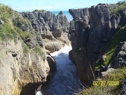
We circled the S. Island counterclockwise. Our trip south was driven by reservations Sunday and Monday to see Milford and Doubtful Sounds in Fiordland in the SW corner. Thursday morning we rose early and drove through the wine country of Marlborough, through the Nelson Lakes National Park and Victoria Mountains toward the Tasman and town of Greymouth. Enroute along the coast, was Pancake Rocks and Blowholes (picture). The unusual formation of the limestone rocks in the area, which resulted from a process known as stylobedding, looks like thin layers of pancakes stacked on top of each other. Caverns in the rock catch water as the waves crash shore, spewing it upward through impressive blowholes. The entire coastline was part of NZ's gold mining region. Dotted all along were signs to old mines.
South of Greymouth lies Hokitika, the home of some of the best greenstone carving in NZ. Greenstone was collected and worked by the Maoris for weapons and jewelry. The beautiful war clubs, known as mere, were quite lethal, but required close range fighting. In other parts of the world, greenstone is known as jade. We spent hours shopping at the various artists studios in Hokitika, and left with a few prize pieces.
We continued on to the Franz Josef and Fox Glaciers. As it was raining and foggy, but both poked their heads out of mountain valleys, and showed just the tip of their majesty. Signs at the Franz Joseph Glacier showed that it is actually growing! In the 1920's the glacier was much smaller than today. That's localized global cooling!
Our destination that night was Wanaka, a ski town located at the south end of Lake Wanaka. We were warned to get gas in Haast, just as we turned inland from the coast. Since it was only 150 km to Wanaka, we put in some gas, but didn't fill up. The road to Wanaka was almost straight up, and the "little engine that might" (as I lovingly refer to our Mitsubishi Mirage) drank her share and then some while hauling us up. By the time we got to Wanaka, after 6 pm, the low fuel light had been on for a half hour. (Did I mention that between towns, NZ is quite empty?) We were glad to settle into a luxury room at the Fern Grotto and enjoy a good meal at Relishes (both recommended). Wanaka is a gateway to the Mt. Aspiring National Park, named after the highest peak at 3093 meters. This led to some interesting business names in Wanaka: The Aspiring Dentist was my favorite, though the Aspiring Insurance Co. and Aspiring Medical Clinic also prompted smiles. Can't say the names inspired confidence!
The secondary road between Wanaka and Queenstown is another straight uphill and then down. It has the distinction of being NZ's highest road! The highpoint is Cardrona, a former gold mining town that was at the heart of NZ's gold rush. The Cardrona Hotel is a lovingly restored hotel and restaurant that dates from the 1860's, and has operated continuously since then.
When we got to Arrowtown, we turned east on Rt. 6, away from Queenstown, to find the Roaring Meg Winery. They make an awesome Pinot Noir that we'd had at Relishes. The winery is set in "the badlands" of Central Otago. The area was arid and desolate: not at all what you'd choose for growing wine grapes. However, through the miracles of irrigation and the protection (from birds) of netting over the vines, some incredibly good wines are produced here. Prior to becoming a goldmine of grapes, Central Otago was the leading gold producing region of NZ. Similar to the US, the NZ gold rush lasted about 2 years in the 1860's. At the Kawarau Gorge Mining Center we visited a preserved mine site. This site was one of the original sources of Kiwi gold, and one of the most lucrative. In 1862, 2 men pulled 38 kg (84#) of gold out of the ground here in two months. That's the world's record for 2 men working 2 months. NZ is ranked 40th in gold production, but is one of the few areas that produces 24 ct (pure) gold. (As info, in 6000 years mankind has pulled 20 cubic meters (700 cu. ft) of gold out of the earth. Gold is heavier than anything but platinum and iridium; 41% heavier than lead.) Even today, there are major gold mines in Central Otago producing significant quantities of gold.
Cooks Straight, the body of water between the N and S Islands, is open to the Tasman on the west and the Pacific on the east. Tidal changes insure that the water is always moving, and weather system blow through, making the crossings notoriously rough. The big ferries carry up to 300 cars, plus trucks, as goods must move between the islands by water. On our trip over, an open truck housed a dozen, rather unhappy and certainly fragrant cows. Our three hour trip was pleasant, and the "inside" portion of the cruise, which was within Queen Charlotte Sound on the South Island was magic. Steep, forested hills rose from deep blue water. Occasionally, houses, accessible only by sea, could be seen on the hills. One Kiwi, returning home after years away, explained that the forests were American Pine, brought to NZ years ago to replace native trees, they liked the environment and spread to cover much of the islands. (Likewise, we learned later, much of NZ's "wild" bush is populated with nonnative species. Those deemed pests are being eradicated, while others are merely accepted.) The ferry docked in Picton, and we headed to our campground to freshen up for an evening with friends.
I should mention that it's common in NZ to stay in camp grounds. Options vary from tents to campers, to basic cabins (coffee pot & cups; communal showers, toilets, and kitchens; you bring linens), to deluxe cabins (a hotel room where you bring linens), to motel rooms. Basic cabins ran about $40-50/night, with deluxe cabins commanding $60-80, depending on the local tourist attractions. We started in basic cabins, and over time graduated to deluxe. Then, we found that mom & pop motels were the same price, but provided linens and had in-room galley-type kitchens.
Allen and Joyce Hogan, from the yacht Sojourner, had just returned home to Picton after a 7 year circumnavigation. Twenty odd years ago, they had started the first boutique winery in the now famous Marlborough Region of New Zealand. Most generously, they invited us to enjoy some 15 yr old Reisling and Gewurtztraminer from their vineyard. A rare treat, the wines would rival the best from Germany. Allen drove us to a point overlooking the sound to watch an awesome sunset before returning to town for a delicious dinner. They gave us good pointers about what to see on the South Island.
We circled the S. Island counterclockwise. Our trip south was driven by reservations Sunday and Monday to see Milford and Doubtful Sounds in Fiordland in the SW corner. Thursday morning we rose early and drove through the wine country of Marlborough, through the Nelson Lakes National Park and Victoria Mountains toward the Tasman and town of Greymouth. Enroute along the coast, was Pancake Rocks and Blowholes (picture). The unusual formation of the limestone rocks in the area, which resulted from a process known as stylobedding, looks like thin layers of pancakes stacked on top of each other. Caverns in the rock catch water as the waves crash shore, spewing it upward through impressive blowholes. The entire coastline was part of NZ's gold mining region. Dotted all along were signs to old mines.
South of Greymouth lies Hokitika, the home of some of the best greenstone carving in NZ. Greenstone was collected and worked by the Maoris for weapons and jewelry. The beautiful war clubs, known as mere, were quite lethal, but required close range fighting. In other parts of the world, greenstone is known as jade. We spent hours shopping at the various artists studios in Hokitika, and left with a few prize pieces.
We continued on to the Franz Josef and Fox Glaciers. As it was raining and foggy, but both poked their heads out of mountain valleys, and showed just the tip of their majesty. Signs at the Franz Joseph Glacier showed that it is actually growing! In the 1920's the glacier was much smaller than today. That's localized global cooling!
Our destination that night was Wanaka, a ski town located at the south end of Lake Wanaka. We were warned to get gas in Haast, just as we turned inland from the coast. Since it was only 150 km to Wanaka, we put in some gas, but didn't fill up. The road to Wanaka was almost straight up, and the "little engine that might" (as I lovingly refer to our Mitsubishi Mirage) drank her share and then some while hauling us up. By the time we got to Wanaka, after 6 pm, the low fuel light had been on for a half hour. (Did I mention that between towns, NZ is quite empty?) We were glad to settle into a luxury room at the Fern Grotto and enjoy a good meal at Relishes (both recommended). Wanaka is a gateway to the Mt. Aspiring National Park, named after the highest peak at 3093 meters. This led to some interesting business names in Wanaka: The Aspiring Dentist was my favorite, though the Aspiring Insurance Co. and Aspiring Medical Clinic also prompted smiles. Can't say the names inspired confidence!
The secondary road between Wanaka and Queenstown is another straight uphill and then down. It has the distinction of being NZ's highest road! The highpoint is Cardrona, a former gold mining town that was at the heart of NZ's gold rush. The Cardrona Hotel is a lovingly restored hotel and restaurant that dates from the 1860's, and has operated continuously since then.
When we got to Arrowtown, we turned east on Rt. 6, away from Queenstown, to find the Roaring Meg Winery. They make an awesome Pinot Noir that we'd had at Relishes. The winery is set in "the badlands" of Central Otago. The area was arid and desolate: not at all what you'd choose for growing wine grapes. However, through the miracles of irrigation and the protection (from birds) of netting over the vines, some incredibly good wines are produced here. Prior to becoming a goldmine of grapes, Central Otago was the leading gold producing region of NZ. Similar to the US, the NZ gold rush lasted about 2 years in the 1860's. At the Kawarau Gorge Mining Center we visited a preserved mine site. This site was one of the original sources of Kiwi gold, and one of the most lucrative. In 1862, 2 men pulled 38 kg (84#) of gold out of the ground here in two months. That's the world's record for 2 men working 2 months. NZ is ranked 40th in gold production, but is one of the few areas that produces 24 ct (pure) gold. (As info, in 6000 years mankind has pulled 20 cubic meters (700 cu. ft) of gold out of the earth. Gold is heavier than anything but platinum and iridium; 41% heavier than lead.) Even today, there are major gold mines in Central Otago producing significant quantities of gold.
New Zealand in 17 Days, Part 1
27 June 2008 | 35 S 174 E
Julia
Our plans to travel NZ were delayed by Papillon's January haul out. Planned for 3 weeks, it stretched to 5, which severely restricted our time to see NZ before our March 15 flight to the States. It wasn't until February 23 that we headed south. First stop, Auckland, to lunch with David and Juliet from the yacht Reflections. What should have been a 3 hour drive turned into an adventure when an accident during a driving rainstorm closed the highway to Auckland. We were detoured at a town called Warkworth onto a road headed for the west coast, and we had no good map as we wanted to buy a detailed regional one further south. A "fairway down" the road we saw a sign to Pukapuka, which we knew was on NZ1 to Auckland, so we hung a left. The road became gravel, then mud, and we wandered about, looking at the waterfalls and wondering if the road would wash out. About an hour later, we finally emerged onto paved road, then ran into NZ1! Now Auckland was only 2 hours off. We enjoyed a delicious lunch with our friends, but said a hasty farewell to get to Waitomo before nightfall. Having seen our first NZ detour, we proceeded with guarded optimism about the rest of the trip.
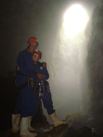
Waitomo is in the western part of the central North Island. It's cave country is known for awesome limestone caves, glowworms, and blackwater rafting. Our introduction was scheduled for 2:00pm Sunday afternoon with Waitomo Adventures. We were abseiling (rappelling) 300 meters (10 stories) into a cave, then hiking out. Our guide was Russell, and it was just the three of us. We donned one- piece suits, harnesses, boots, and hard hats, then hiked about � mile to the entrance to the cave. From the top it looked like a VERY DEEP sinkhole with a stream at the bottom. We walked out onto a mesh platform, and tied into what looked like very new rope (good!). Russell coached us on how to control our descent by wrapping the line each of us was riding on around our right foot. It took about 30 minutes to get to the bottom, but what a feeling of freedom! (picture) We followed the stream deeper into the cave in search of glowworms. These are a critter unique to NZ that are actually the larvae of an insect that glow in the dark (think fireflies). They congregate on the roofs of caves and drop sticky strings to catch their prey. They're highly efficient producers of light (we could learn something here), and "glow" for about 9 months while they gain strength and mass before morphing via a cocoon into a moth-like creature. As adults, they live about 3 days: long enough to mate and lay eggs. They don't even eat at this stage. We crawled deep into a small cave and turned off the lights to be greeted by a "star-filled night sky." The insects that are the glowworm's prey mistake the glow for stars, and fly into the sticky strings. Cool. Of course for us the rush wasn't over, as the hike out involved several ladders, the longest of which was 120 rungs high! Fortunately, Russell had candy bars and drinks to fuel us before the climb. Once outside, we were fully exhilarated, but worn out.
Our next stop was far above, in the mountains of Tongariro National Park. The Park, which boasts three main volcanic peaks, several alpine lakes, and hot springs, is on land held sacred by the Maori. In 1887, Chief Horonuku Te Heuheu Tukino IV gifted the volcanoes and surrounding land to the Crown and people of NZ to preserve the mana of the Ngati Tuwharetoa tribe. In 1894, Tongariro National Park was established by an act of Parliament. Mt. Tongariro is the baby of the volcanoes, at 1967 meters. Mt. Ngauruhoe, of Lord of the Rings fame, reaches 2289 meters and Mt. Ruapehu comes in at 2797 meters. We set up camp at Ohakune on the slopes of Mt. Ruapehu, then drove up the mountainside to the Turoa Ski Area. Temperatures went from the 80's in Ohakune to blustery 40's atop the mountain. The surrounds, the cold, barren mountain was the embodiment of the Dark Lord Sauron's evil. We gratefully escaped to the Waitonga Falls walking track a couple of km straight down the mountain. Our goal was Waitonga Falls, at 39 meters, the park's highest waterfall. We started out through native bush, then crossed an alpine swamp on a boardwalk. Half way across the wind kicked up and rain plastered our backs. Once back in the bush we struggled down, down, down about 1.5 k (~1 mile) to the floor of the falls, only to find that due to the summer weather it was reduced to a trickle!
Tuesday, Feb. 26, found us driving back to sea level, following the Whanganui River to Wanganui (city). The Whanganui River retains the Maori spelling and pronunciation, Fan-ga-nu'-ee, while the name of the city has been anglicanized to Wan-ga-nu'-ee. The river road was 90 km of steep downward grade on gravel. We were glad to go slowly, as shepherds let their flocks roam freely, often across the road. The River had been a major tourist attraction in the early 1900's, when paddlewheel boats brought people up from Whanganui to enjoy outdoor adventure on the river rapids and rough mountains. Today, the water levels are 12' below what they were then, due to draw down for hydroelectric and agricultural projects. Even flat bottom boats would have a hard time getting upriver today. A treat on the way down was a brief visit to a convent in Jerusalem. St Joseph's church was built there in 1893, and features a beautiful alter that combines Maori and Christian motifs. The nuns maintain the grounds, which include a prayer garden, housing, and vegetable gardens. Wanganui itself turned out to be a delightful town with a quaint commercial district featuring good restaurants and interesting shops. Unfortunately, we ran out of time before visiting their excellent Regional Museum, but we did spend the late afternoon at Virginia Lake Scenic Reserve.
New Zealand, Introduction
27 June 2008 | Whangarei, 35 43S 174 19 E
Julia
New Zealand
November 12, 2007 to June 30, 2008
We arrived in Opua, New Zealand, about 8:00 am on November 12. We were one of the last yachts to make it in before the weather window from Tonga closed. Boats 1-3 days behind us were caught in a strong low pressure system with 60 knot winds that forced many to turn around and run back toward Tonga. We were glad for our policy of maintaining a minimum of 5 knots, whether it took sail or power to do so, as we had been able to motor through calms and soar with the winds.
Opua is a tiny town that consists of a large marina and a few shops. The nearest real town, with grocery, is Pahia, about 5 km away. After so many months at sea, the cruisers marveled at the rolling green hills, dense pine forests, and architecture that looked familiar. Pahia is just across the river from the Waitangi Treaty grounds where the native Maori chiefs signed the treaty with Great Britain in 1840. Although the islands were discovered by Dutch commander Able Tasman in 1642 (who named it Nieuw Zeeland, or "New Sealand"), Europeans didn't visit again until 1769 when both James Cook from England and Jean de Surville from France made contact. Both countries continued exploration through the 1700's, and in the 1790's whalers and sealers began calling on NZ. Missionaries arrived in 1814, and like the Polynesians in the islands north of them, the Maori readily converted to Christianity. By the late 1830's there were enough Brits here to need Maori protection, and the Maori needed British goods.
New Zealand spans about 1600 km (1000 mi) north to south, including Stewart Island. That's a little over the distance from Boston to Charlotte. Within that distance, every imaginable geographic landscape ( except desert) can be experienced. NZ sits astride the intersection of the Pacific plate and the Asian/Indian plate, which results in continuous geologic change. The geography of the islands as we see them is less than 10,000 years old! The North Island is largely volcanic, with Mt. Ngauruhoe (Mt. Doom) being it's most famous, though not most destructive, volcano. The South Island boasts the Southern Alps, 635 km of staggering peaks. Fiordland is reminiscent of the coast of Norway, while Central Otago takes you to the heart of North Dakota's badlands. Three kinds of penguin play on her coasts, and the unique and defenseless Kiwi bird populates her forests. The population and land area of the entire country is about the same as Colorado, with major population centers in Auckland, Wellington, Christchurch, Hamilton, and Dunedin.
After a week in Opua, we began our journey south to Whangarei (Fang-ar'-ay), which was our base while in NZ. Our course took us through the Bay of Islands, around "Hole in the Rock" at Cape Brett, past the Poor Knights Islands, and around Bream Head and Whangarei Heads, then up the river to the Town Basin Marina. Our choice was dictated by the proximity to Norsand Boatyard, which was one of the few yards that could haul a large catamaran. Our first east coast anchorage was at Whangamumu Harbor, the site of an old whaling station. Rather unique, whalers there would net(!) the whales just outside the harbor, then drag them in for processing. They used a railroad to pull the animals on shore to butcher, and canned the meat and rendered the fat on sight. From the late 1800's to around 1920 canned whale meat was a staple of the NZ diet.
Whangarei is nicknamed "Raingarei" for the almost constant rainfall precipitated by the surrounding hills. During December, it certainly lived up to its reputation. Not until after Christmas did we venture out to explore the rest of the Northland. Our goal was Waipoua Kauri Forest on the west coast near the top of the N. Island. Kauri trees are NZ's giant evergreens. The largest remaining tree, Tane Mahuta, is over 50 meters tall, with a girth of about 16 meters. It's estimated to be about 2000 years old. Like its Sequoia brethren, the Kauri once covered most of NZ, but have been almost exterminated by loggers and fires. In the 18th and early 19th centuries, ships transporting prisoners to Australia needed new spars to refit and return to Europe. The tall, straight Kauri trunks provided perfect mast material, and thousands of trees were cut for ships timber. Others became furniture, and still others were felled as fuel. One Kiwi said "NZ has few natural resources. The country was built on Kauri."
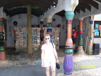
Our Northland tour took us through the town of Omapere on Hokianga Harbour. The harbor was protected by a sand bar from the Tasman Sea. The day we were there it was calm and navigable, but the locals told stories of ships of old being trapped for 3-4 months waiting for weather in which to cross that bar. Traveling NE we visited KeriKeri, which is a beautiful town full of organic vegetables and wineries. It reminded us of our Finger Lakes (NY) tour back in the 1980's. The return trip to Whangarei went through Kawakawa, home of the famous Hunderwasser Toilets. Yes, you read it right: the municipal facilities are a major tourist attraction. Frederich Hunderwasser was a painter, architect, ecologist and philosopher who was declared a National Treasure by NZ. In return, he designed the public toilets for the main street of Kawakawa. The building has ceramic columns, a garden roof, and playfully tiled interior. It's the only tourist attraction we remember where no one paid to enter, and everyone left something behind! (picture)
November 12, 2007 to June 30, 2008
We arrived in Opua, New Zealand, about 8:00 am on November 12. We were one of the last yachts to make it in before the weather window from Tonga closed. Boats 1-3 days behind us were caught in a strong low pressure system with 60 knot winds that forced many to turn around and run back toward Tonga. We were glad for our policy of maintaining a minimum of 5 knots, whether it took sail or power to do so, as we had been able to motor through calms and soar with the winds.
Opua is a tiny town that consists of a large marina and a few shops. The nearest real town, with grocery, is Pahia, about 5 km away. After so many months at sea, the cruisers marveled at the rolling green hills, dense pine forests, and architecture that looked familiar. Pahia is just across the river from the Waitangi Treaty grounds where the native Maori chiefs signed the treaty with Great Britain in 1840. Although the islands were discovered by Dutch commander Able Tasman in 1642 (who named it Nieuw Zeeland, or "New Sealand"), Europeans didn't visit again until 1769 when both James Cook from England and Jean de Surville from France made contact. Both countries continued exploration through the 1700's, and in the 1790's whalers and sealers began calling on NZ. Missionaries arrived in 1814, and like the Polynesians in the islands north of them, the Maori readily converted to Christianity. By the late 1830's there were enough Brits here to need Maori protection, and the Maori needed British goods.
New Zealand spans about 1600 km (1000 mi) north to south, including Stewart Island. That's a little over the distance from Boston to Charlotte. Within that distance, every imaginable geographic landscape ( except desert) can be experienced. NZ sits astride the intersection of the Pacific plate and the Asian/Indian plate, which results in continuous geologic change. The geography of the islands as we see them is less than 10,000 years old! The North Island is largely volcanic, with Mt. Ngauruhoe (Mt. Doom) being it's most famous, though not most destructive, volcano. The South Island boasts the Southern Alps, 635 km of staggering peaks. Fiordland is reminiscent of the coast of Norway, while Central Otago takes you to the heart of North Dakota's badlands. Three kinds of penguin play on her coasts, and the unique and defenseless Kiwi bird populates her forests. The population and land area of the entire country is about the same as Colorado, with major population centers in Auckland, Wellington, Christchurch, Hamilton, and Dunedin.
After a week in Opua, we began our journey south to Whangarei (Fang-ar'-ay), which was our base while in NZ. Our course took us through the Bay of Islands, around "Hole in the Rock" at Cape Brett, past the Poor Knights Islands, and around Bream Head and Whangarei Heads, then up the river to the Town Basin Marina. Our choice was dictated by the proximity to Norsand Boatyard, which was one of the few yards that could haul a large catamaran. Our first east coast anchorage was at Whangamumu Harbor, the site of an old whaling station. Rather unique, whalers there would net(!) the whales just outside the harbor, then drag them in for processing. They used a railroad to pull the animals on shore to butcher, and canned the meat and rendered the fat on sight. From the late 1800's to around 1920 canned whale meat was a staple of the NZ diet.
Whangarei is nicknamed "Raingarei" for the almost constant rainfall precipitated by the surrounding hills. During December, it certainly lived up to its reputation. Not until after Christmas did we venture out to explore the rest of the Northland. Our goal was Waipoua Kauri Forest on the west coast near the top of the N. Island. Kauri trees are NZ's giant evergreens. The largest remaining tree, Tane Mahuta, is over 50 meters tall, with a girth of about 16 meters. It's estimated to be about 2000 years old. Like its Sequoia brethren, the Kauri once covered most of NZ, but have been almost exterminated by loggers and fires. In the 18th and early 19th centuries, ships transporting prisoners to Australia needed new spars to refit and return to Europe. The tall, straight Kauri trunks provided perfect mast material, and thousands of trees were cut for ships timber. Others became furniture, and still others were felled as fuel. One Kiwi said "NZ has few natural resources. The country was built on Kauri."
Our Northland tour took us through the town of Omapere on Hokianga Harbour. The harbor was protected by a sand bar from the Tasman Sea. The day we were there it was calm and navigable, but the locals told stories of ships of old being trapped for 3-4 months waiting for weather in which to cross that bar. Traveling NE we visited KeriKeri, which is a beautiful town full of organic vegetables and wineries. It reminded us of our Finger Lakes (NY) tour back in the 1980's. The return trip to Whangarei went through Kawakawa, home of the famous Hunderwasser Toilets. Yes, you read it right: the municipal facilities are a major tourist attraction. Frederich Hunderwasser was a painter, architect, ecologist and philosopher who was declared a National Treasure by NZ. In return, he designed the public toilets for the main street of Kawakawa. The building has ceramic columns, a garden roof, and playfully tiled interior. It's the only tourist attraction we remember where no one paid to enter, and everyone left something behind! (picture)
Tonga
26 June 2008 | 20 S 174 W
Julia
Tonga
September 9, 2007-November 3, 2007
The Kingdom of Tonga consists of five island groups (N to S): The Niuas, Vava'u, Lifuka, Ha'apai, and Tongatapu. During our two months in Tonga, we'd spend time in Vava'u, Ha'apai, and Tongatapu.
Our 250 mile sail from Niue to Tonga was quite pleasant, with winds in the teens to mid-20's and seas in the 10' range. Only as we approached Vava'u did storm clouds gather, dumping rain just west of the Island group (near the entrance), and welcoming us with an intense rainbow. Sailing into the islands, after having had miles of sea room, is a bit uncomfortable. For those of us from the US east coast, land means shoals. Not so in Vava'u, where islands and islets poke up from 500'+ depths to tree covered hillsides hundreds of feet high. Not until we neared Neiafu harbor did depths begin to shallow. Neiafu harbor is on the south side of Vava'u island, tucked deep within the curves of the land, which forms a natural hurricane hole. The harbor is one of the few places in the South Pacific where one might consider riding out cyclone season on a mooring. Hence its historic name, the Port of Refuge.
Vava'u has about 17,000 people, 12,500 of whom live on Vava'u island itself. The town of Neiafu offers several restaurants, three groceries, hardware, butcher, bakeries, banks, and bars. As we were there in the dry season, it was dusty and seemed a bit "wild west" in appearance, though not in character. The Tongans were quite friendly and quick to smile and help, though also quick to ask for goods or tips if they thought they could get it. (True in Neiafu more than the out islands.) The vegetable market was opened 6 days/week and offered the basics. On Thursdays, you could get a big basket of baby clams: 300 for T$8 (US$4). They were excellent, and Jim became expert at steaming and cleaning them.
Life on the hook in Neiafu centered around the Aquarium Caf�. We rented moorings from them, ate tapas there, and joined with other cruisers to take a go-cart tour of the island. That was a blast: Eight fifty and sixty-somethings rollicking around the jungle in open go carts held together with baling wire, rope, and mud! We ventured to remote cliffsides on the north side of the island; a black sand beach which housed the ruins of a night club opened only one night before a cyclone swept the business away; and lush plantations that raised bananas and taro. Another evening, Gail Funk from Fifth Season played harp and sang for us during dinner at the Aquarium. She has a beautiful voice that would put many professional singers to shame.
The true attraction of Vava'u is the myriad of small islands that provide beautiful anchorages for yachts. The Moorings Guide listed 42, and many others were possible. The choice of anchorage was determined by weather, as those further east were more exposed to the tradewinds, while those on the west side of the islands were often exposed to southerlies. Our first choice was Hunga, which was probably the westernmost anchorage. Entrance was through a narrow channel, bordered by rocks on both sides, plus one in the middle, that afforded 5' at high tide. Papillon draws 4', so we went for it! Inside, the water was like a lake, completely surrounded except for the narrow channel we entered through and a very shallow (dingy at high tide only) gap to the south. Only one other boat, Blue Stocking, shared the space with us. While anchored, villagers came out to sell bone carvings and trade for fruit. We traded one man children's toys and a ball for fruit and a handful of carvings.
At Vaha'eita we were delighted by schools of fish that "charged" around the boat at odd times during the day. They were a combination of sunfish, baby barracuda, and sea bass. (Unfortunately, I only caught barracuda!) This anchorage was near a colorful Coral Gardens that was at snorkeling depth during high tide. We swam over with Jim and Mary from Journey, and poked around a while, only to realize that once the tide dropped we'd be trapped! A few scrapes later, we were back on our side of the reef.
The island of Tapana housed a most unusual Spanish restaurant, La Paella. We joined Liz and Mark from Scholarship for a delightful evening, that was easily the best food since Mexico! The same anchorage had a floating art gallery, owned by an expat from Seattle. At Ano Beach there was an awesome Tongan feast, complete with craft show, dance, and kava ceremony.
We tucked in behind Kapa Island for a chance to snorkel and picnic on Nuku Island. After arrival we dinked to Swallows Cave. The cave is entered in the dingy, preferably after 3:00 pm, as the sun is low enough to shine into the cave. When we got back, we could see a storm approaching from the NW, so we battened down and waited. Forty knot winds pushed us toward the reef between Kapa and Nuku, as we (and the others in the anchorage) sat with our engines idling, just in case. The Mighty Bruce held well, and we settled in for a quiet night. Our snorkel the next day was disappointing, but the picnic we shared with Scholarship was a delight. Around dinner time, as we all relaxed on our boats, the wind kicked in from the south, again blowing 40 knots. This time two boats dragged as the winds blew them into deeper water and their anchors unseated. One shot past us so fast that Jim thought I'd turned the engines on full throttle ahead! Again, Papillon held her own and sometime after 2:00 am we slept.
The Ha'apai Group of islands is totally different from Vava'u. The islands are low and sandy, frequently surrounded by beautiful coral, and overall poor. There's really no industry, save tourism, and precious little of that. Subsistence farming and fishing provide most of the population's dietary needs. Medical care is provided by the government, though drugs are expensive. Working age men generally take jobs in Nukualofa. Native people will trade readily with yachties for things they need.
We visited many beautiful anchorages in Ha'apai, including Foa where we attended an excellent concert at a local resort. Cruiser Allen Hogan from the NZ yacht Sojourner plays awesome flute and treated a number of us to his talent. (More about Allen in the NZ South Island blog.) On Ha'afeva we were treated to lunch at the home of one of the locals. Ten cruisers were invited for a lobster lunch, and the lobsters flowed like water under our keel. Somehow we ate our fill of lobster, fish, taro, cooked banana, and sweet potatoes, and each walked out with a lobster the length of Jim's forearm. We were all only too happy to give them whatever they needed, which included asprin, dive fins, masks, prescription eye glasses, crayons, pencils, and colored paper, coloring books, fishing gear, and cosmetics. Good trades were made by all!
Nukualofa is the capital of Tonga, located on Tongatapu. It's a large, dusty town with an interesting mix of wealth (gov't and corporations) and poverty. You could get almost anything here, if you could get someone to understand what you were looking for. There were two areas for yachties: the main wharf in town (closed in and dirty) or Pangaimotu Island, home of Big Mama's Yacht Club. We stayed at the latter, using their launch to go to town when we needed to for supplies or clearance.
Big Mamas provided a delightful cruiser hang out with nightly happy hour and weekly buffets. As the weather pinned us down for over three weeks, and our numbers swelled, we had many great parties with Mama. It's hard to say who was more reluctant to see the fleet leave: Mama or us? (PS: Mama's is now the SSCA Cruising Station in Tonga. She may be the only one in the So. Pacific. Please let her know if you're an SSCA member.)
On November 3, we finally had a weather window to go to NZ, and the fleet was off!
| Vessel Name: | Papillon |
| Vessel Make/Model: | Custom Crowther 390 |
| Hailing Port: | Bokeelia, Florida |
| Crew: | Julia and Jim |
Gallery not available
Papillon
Who: Julia and Jim
Port: Bokeelia, Florida