
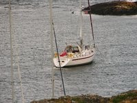
Queen’s Ransom circumnavigating Ireland and the Orkneys
Queen’s Ransom III is a Najad 520 from the UK
27 November 2023 | Chatham
26 November 2023 | Queenborough, Isle of Sheppey
25 November 2023 | Ramsgate
10 November 2023 | Weymouth
15 October 2023 | Dittisham, River Dart
14 October 2023 | River Yealm
22 September 2023 | Fowey
03 September 2023 | River Yealm
02 September 2023 | New Grimsby Sound
01 September 2023 | Tresco, Isles of Scilly
31 August 2023 | Celtic Sea
30 August 2023 | Great Saltee Island, County Wexford, Ireland
28 August 2023 | Castletown, Isle of Man
27 August 2023 | Bangor
26 August 2023 | Sound of Islay
25 August 2023 | Oban
24 August 2023 | Oban
23 August 2023 | Mallaig
22 August 2023 | Loch Duich
21 August 2023 | Stornoway
The first part of the voyage
05 July 2009 | London
Ulric
Queen's Ransom plans to set off on her transatlantic adventure on July 10th 2009. The first leg will take us from Gosport to North West Spain. This is a passage of some 550 nautical miles which will take four days, but we are planning to stop along the way. First she will head West in the English Channel for Falmouth or possibly use the Channel Islands as a stepping stone in the way to Brittany 200 nautical miles away. She is likely to have to brave Westerly head winds. We have previously called on either mainland France or the island of Ushant on the way to Spain; this depends on the conditions as Ushant is exposed to Westerly winds. Brittany is a great cruising area with its varied coast and offshore islands, but it is also quite challenging with huge tides. The French cuisine is an added advantage. Unfortunately, the time here is likely to be short, as we are yearning to explore a cruising ground further afield.
Queen's Ransom will then cross the Bay of Biscay which is 350 nautical miles across to make a landfall at La Coruna or a nearby harbour. The prevailing winds are between SW and NW in the Bay, but these winds incline towards Northerly as we close in on Spain. There are plenty of dolphins in the Bay of Biscay and whales can be seen too with some luck. Galicia is a favourite area with its Rias (rivers) on both the Spanish North and West coasts. It is a very authentic part of Spain as well with fantastic scenery, wondeful small rural towns and two exciting cities: Vigo and La Coruna. The time spent here will depend how promptly we got on with our Biscay crossing and indeed how smooth the passing was. Last time South bound we had to tack all the way across.
The second leg of the passage will start at the Southernmost point that Queen's Ransom reached in 2007; i e Vigo close to the Spanish/Portuguese border. This is another 100 nautical miles from La Coruna. The passage South along the Portuguese West coast is 350 nautical miles to the start of the Algarve; the Portuguese South coast. We should have following winds and currents from the North on this stretch. During the Summer the wind comes in the afternoon. Our trip will comprise of a number of day sails calling on Oporto and Lisbon and a number of small harbours. From Bayona, there are eleven evenly spaced 30 nautical mile day hops to Lagos which is situated around the corner at Cabo de Sao Vicente.
First stop in Portugal will be Viana do Castelo founded in 1258 as Viana da Foz do Lima. Detlev Jens writes in his excellent cruising guide (South West Spain and Portugal, A cruising companion published by Nautical Data Ltd): "a place full of history, character and charm - a beautiful city on the mouth of river Lima with many fine Renaissance and Baroque buildings. There are a number of long sandy beaches close by." Next stop is Oporto at the Rio Douro. We may moor at the commercial harbour Leixoes or go up the river. Ditlev Jens again: "Porto is one of the two major centres of Portugal and secretly sees itself as the capital. Indeed, Porto is not only of great commercial importance, but also has a thriving commercial life which competes fiercely with that of Lisbon // disappear in the labyrinth of narrow, steep side streets into the old city. This is Ribeira, the oldest quarter of Porto which cascades down the river bank."
Next is Aveiro; Ditlev Jens writes: " .... a quite remarkable and pretty commercial town. It is often called the little Venice of Portugal, as it is surrounded and crisscrossed by many small canals. Aveiro sits at one end of a bizarre lagoon with salt pans simmering white under the sun and piles of salt on the narrow causeways between.". The following three harbours are: Figueira da Foz (a typical Portuguese harbour town and attractive seaside resort close to the ancient university town Coimbra), Nazare (a fishing harbour) and Peniche (an ancient fishing town on the rocky promontory of Cabo Carvoeiro with baroque churches and an old fort, close to the historic town of Obidos). Our last port has the island Isla da Berlenga nearby offshore which sounds worth a visit.
One of the main attractions will be Lisbon. Imelda and I had a very enjoyable weekend break here one Autumn a few years ago. The river Tejo around the corner of Cabo da Roca is situated 35 nautical miles south of Peniche. Lisbon is on its Northern shore. Ditlev Jens captures it when he writes: "Lisbon must be the most romantic and inspiring European capital and still has an exotic feel and nostalgic flair that is not found in any other European major metropolis ...". He highlights that this most enticing city which on one hand combines a slower pace and a colourful cultural life with strong bonds to a long history with the "vibrant sparkling scene of today". Not to mention the old fashioned architecture which is always close to my heart. We will either moor at Belem, which is Lisbon's Greenwich with a strong maritime history from the voyages of discovering the world in the 15th and 16th century, or Doca de Santo Amaro or Doca de Alcantara for the ease of access to the city.
Next port of call will be Sesimbra or Setubal some 30-40 miles to the South. Setubal which is a traditional fishing town with fantastic beaches may be our choice. It also has a very pretty old part "noted for romantic narrow streets and buildings in the Manueline style..." Whatever the latter may be?! Sines, the birthplace of the explorer Vasco de Gama, is some 30 nautical miles to the South and the last harbour before the longer 60 nautical mile stretch to the Algarve. Sines is said to be a picturesque but sleepy town.
I am planning to leave the boat in Lagos in Southern Portugal for a while returning to London. It is 20 nautical miles East of the cape that is the beginning of the Algarve. It is also close to Faro airport. According to the cruising guide it is a small white washed place with attractive buildings and good facilities to leave a boat, renowned for its sandy beaches.
The third leg will be the first novel crossing straight out in the Atlantic to Madeira. This is planned for October. It is a passage of 500 nautical miles which should take around three days. The winds should predominantly be Northerly which should provide for fast reaching conditions. We will call at the small island of Porto Santo which is situated some 50 nautical miles North East of Madeira.
The forth leg is from Madeira to the Canaries. The distance is 240 nautical miles and should be covered in a day and a half. We hope to spend the children's Autumn half term break here and see some of the island group. It is also one of the places where sea mammals are seen most on this side of the Atlantic.
Queen's Ransom will be left for some time in the Canaries before her Transatlantic crossing in the last week of November. There are two alternatives for the crossing: either a direct route which is 2,750 nautical milles (some 17 days) or calling on the Cape Verde Islands en-route. The latter would add some 200 nautical miles and therefore a day and a bit.
The Norwegian adventure 2008
13 May 2008 | London
Ulric
In 2004, National Geographic selected the Norwegian fjords as the world's best travel destination ahead of other dream lands such as the Galapagos Islands and the Great Barrier Reef of Australia. The prestigious travel magazine also placed Norway's fjords ahead of other comparable natural wonders such as the fretted coast lines of Chile and New Zealand. It is easy to see why; writes the Lonely Planet and continues: "Scoured and gouged by glaciers, of which a few vestigial traces still roan and creek, these formidable deep, sea-drowned valleys are pincered by almost impossibly rugged terrain".
Queen's Ransom III's first longer cruise was to Norway in 2006 to attend our friends Trond and Lee's wedding on a beautiful island in the Oslo Fjord. This time the idea is to explore the area from Stavanger in the South to Sognefjord in the North. Fjord Norway starts to the South with Lysefjord just East of Stavanger; "The iconic and hauntingly beautiful Lysefjord is home to the world famous and perilious look out points of Preikestolen (Pulpit rock; with astonishingly uniform three sides 604m to the fjord below) and Keragsbotten which add a touch of danger to the otherwise sedate fjord experience. All along the 42 km long Lysefjord (Light fjord), the granite rock glows with an etheral, almost ambient light, even on dull days, all offset by a perpetually luminous mist." (from Lonely Planet). Lysefjord which cuts to the East has steep sides rising to 900m and at times only 200m across. The "Preikestolen" is referred to: "it is quite simply a remarkable place, a vantage point unrivalled else in the world."
Stavanger is designated as the 2008 European City of Culture. The Lonely Planet writes about Norway's fourth largest city: "A lively cosmopolitan city that has never lost its small town feel. Home to a well preserved timbered old town, an historic harbour..." It is situated on the "Bay of Islands"; Norwegian version!.
On the cruise North, we are likely to call at Haugesund; founded in 1854 as a herring port. Lonely Planet writes about the town that it lies well off beaten routes and is seldom visited by travellers, which is shame because it is a pretty place with a vibrancy that belies its size. Apparently fresh fish and strawberries are sold on the quay.
Continuing North, the small archipelago of Rovaer is close by with "attractive offshore low rocky islands and islets" according to the pilot book "Norway" written by Judy Lomax and published by the Royal Cruising Club Pilotage Foundation (first edition 2007). This is an excellent publication filling a gap between Norsk Lods which is aimed for commercial shipping and previous much less detailed cruising guides such as the Norwegian Crising Guide (Armitage and Brackenbury, Adlard Coles 1996). Next we will pass by Sletta "dangerous sea area" which is a short unprotected stretch where the depth shoals from 250m to 2m.
Bomlafjord next runs 15 M North East to the mouth of the Hardangerfjord. Holsnoy is an island that used to be an important Viking trading centre at the cross roads of the North South inner lead and Hardangerfjord. Maybe, we anchor at Klostervag; an isthmus with the ruins of a 12th century Augustinian monestry and hospital.
From this point Hardangerfjord penetrates 70M inland between snow covered montains of 1,500m. Judy Lomax writes: "the outer fjord, ... , includes several fjords and sounds below steep wooded slopes and waterfalls. The inner fjord, encompassing six fjords, has even more spectacular steep-sided scenery. Folgefonn glacier on the peninsula between the outer fjord and the long inner arm of Sorfjord can be seen from a distance."
A possible harbour for the Bondhus glacier is Sunndal in Maurangsfjord with a population of 70. From here the ascent should be four hours while the decent two.
Should we continue further up Hardangerfjord, Norheimsund is an alternative. A 3,200 town and according to the pilot superb scenery. Views of mountains and Folgefonn glacier to the south: Norway's third largest icefield. Movatn lake beyond the head of bay, leading to Steindalsfossen waterfall which was almost every Summer 1889-1914 by Kaiser Wilhelm II.
Leaving Hardangerfjord North, we would pass through Lokksund to Bjornafjord; a spectacular 6M short cut between the mainland and Tysnes; several beautiful anchorages are recommended here: Teroysund, Selvig and Gripnesvag.
Raunafjord and Byfjord is leading us past the Flesland Airport to downtown Bergen. We will berth at the pittoresque harbour Vagen in the town centre. This is the original harbour which is now UNESCO World Heritage listed (58 wooden water front structures are listed) with converted wharves, narrow streets and exceptional old houses. The Lonely Planet is lyric about this beautiful city with vibrant fish markets, stunning views from its cable car, dynamic cultural life and also retaining a slow pace of life.
Bergen is Norway's second largest city with a population of 203,000. It is built in bowl below seven mountains and surrounded by seven fjords. It was founded by King Olav Kyrre in 1070 and Norway's capital city and the home of its kings between 1240 and 1835. 70 per cent of the population was wiped out in the Black Death in 1349. From the 14th century, it bacame an important Hanseatic League Port. Judy Lomax also points out in her excellent pilot book that it has the reputation for being the wettest place in Norway with rain 260 days per year! We will sample the fish, fruit, vegetable markets as well as the butchers and bakers to sustain it.
Edward Grieg, undeniable Norway's greatest composer, is inextricably tied to Bergen. We will visit his coastal home Troldhaugen which he spent every summer between 1885 to his death in 1907. His first biographer, Aimer Grovald, noted that it is impossible to listen to Grieg without sensing a a light fresh breeze from the blue waters, a glimpse of grand glaciers and a recollection of the mountains of Norway's Western fjords. We will play his music onboard!
North of Bergen, Lomax writes, there are fewer yachts and the motorboats are mainly working vessels from the islands. We may call at Fedje; a low island surrounded by 125 other island and rocks where Hjeltefjord meets Fensfjord. Its lagoon like bays on its North side has been inhabited for 4,000 years.
On the way North to Sognefjord, Masfjord is a recommended deep fjord with steep-to 900m wooded mountain that create a spectacular scenary. Andvik would be a possible mountain anchorage.
From Fensfjord, we plan to enter Sognesjoen through Mjasund. A number of anchorages here would be possible here Nappsvag on Mjomna, Krakevag on Sula with high granite ledges as we enter Sognesjoen or the old Viking settlement of Kvitoy.
I quote Judy Lomax again to present Sognefjord: "Norway's longest fjord penetrates inland from the sea for 115 miles, between snow covered mountains raising to 1,800 metres. On average it is 2.5 miles wide. At the mouth it is 200 metres deep, but further inland more than 1,300 metres. ... The highest mountains 1,700 - 1,800 metres are around Aurlandsfjord, a major branch to the South. Although theere are few large settlements, there are several stave churches, neat farms, deciduous and coniferous woods, fertile valleys and glimpses of glaciers soften its grandeur in its upper reaches. ... The most spectacular scenery is in Fjaerlandsfjord below glaciers descending from the Jostedal glacier, and Naroyfjord, a narrow canyon branching off Aurlandsfjord and in places 200m wide between sheer mountain walls of 900m high. It is not navigable in the Spring as melting snow and ice from the mountains frequently cause boulders to fall in the fjord below." However, that should hopefully not be a problem in July!
We probably follow the Southern shore inbound as the outgoing current that can reach 1.5-2.5 knots in Summer around headlands is along the Northern shore. The pilot descibles the outer fjord having rain and relatively mildness of maritime climate while the inner reaches are warmer in Summer, but also exposed to squalls. I am warned that it is motoring as it is either no or too much win.
Our chosen anchorages are Rutledal among the skerries on the South side as you leave Sognesjoen to enter the fjord proper. The next one is Fretheim in Indrefjord surrounded by wooden slopes with cliffs, as well as six major waterfalls and many smaller ones. There is also a field of wild raspberries.
We some back up anchorages on the Northern shore: Lavik, Vikum, Vadheim and Kvamsoy; the latter being the most important harbour of the fjord during the days of sail. Fuglsetfjord, Ortvik, Vik and Fresvik serve the same purpose for us on the Southern side. The latter is already in Aurlandfjord which leads to Bakka in Naroyfjord which is one of two main goals is a small village in the narrow fjord with dramatic scenery; isolated farms and cascading waterfalls. At the head of Naroyfjord at Gudvangen is Kjelsfossen; one of the 10 longest waterfalls in the world.
On the Northern shore Esefjord may be a stop on our way up Fjaerlands fjord. It was artist centre late 19th and early 20th century. Good to keep wife's interest up! It was also a holiday retreat for Kaiser Wilhelm 1910-1914 and should have several 19th century buildings including the hotel and the English (!) Church.
Finally ultimate destination is Fjaerland another 14M up the Fjaerlandfjord. Jostedalsbreen is continental Europe's largest icecap, covering 487 sq km, and is 400m thick in places. The farming village of Fjaerland is also the book capital of Norway! According to the Lonely Planet, it essentially hibernates between October and April. Futhermore, it says this glacier is actually advancing rather than shrinking. Encouraging in times of glacier death following global warming!
The passage Gosport to Stavanger July 2008
01 March 2008 | London
Ulric

The plan is to take Queen's Ransom from her home port Gosport to Lowestoft in Suffolk. This would be the departure point for her North Sea crossing to Stavanger. I hope to set sail on Saturday July 12th; weather permitting.
The first leg is likely to be singlehanded with three day hops. The first one would be to sail to Eastbourne (60 Nm). Average wind would provide running and broad reaching conditions with some 11 kn of Westerlies. The next hop would be to Ramsgate and the final hop across the Thames estraury (60 Nm) and North along the Essex and Suffolk coasts to Lowestoft (71 Nm). As we pass the first Queen's Ransom homeport of Dover we increasingly are likely to get the wind on the beam.
The next leg will be the North Sea crossing. I will be joined by my brothers Peter and Bjorn, as well as a friend Barnaby; a Queen's Ransom Iberian adventure alumni!. We meet up in Lowestoft on Friday for setting out to sail 410 Nm to the North to Stavanger. Vitual Passage Planner forecasts 2.4 days with a 100 per cent beam and tight reach. I expect us to arrive at Stavanger between midday Monday and Tuesday.
| Vessel Name: | Queen's Ransom III |
| Vessel Make/Model: | Najad 520 |
| Hailing Port: | Medway, UK |
| About: | |
| Extra: | |
| Home Page: | http://www.queens-ransom.com |
Gallery not available
Queen's Ransom and crew
Port: Medway, UK