Adventures - Aboard the Lady J
29 June 2023
20 June 2023
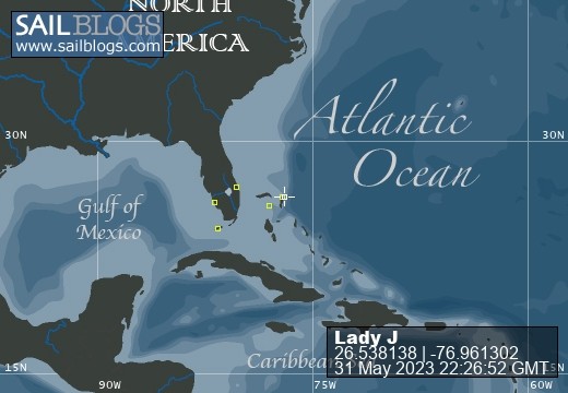
31 May 2023 | Treasure Cay
25 May 2023 | Marsh Harbour
01 May 2023 | Hopetown Marina
25 April 2023 | Guana Cay Harbor
23 April 2023 | Hopetown
20 April 2023
16 April 2023
09 April 2023
06 April 2023
03 April 2023
31 March 2023
13 May 2016
10 May 2016
08 May 2016
08 May 2016
01 May 2016
28 April 2016 | Big Majors Spot
Day to Day Planning in the Exumas
08 May 2016
Sunday-Tuesday, May 1-3, 2016
As mentioned earlier, trip planning in the Exumas is a never-ending unpredictable challenge. And it begins with the weather forecast. Over the next few days, a system is forecast to move in and shift the wind direction from the prevailing easterlies to west and northwest. Normally, not a big issue, but most of the Exuma anchorages such as Big Majors are well protected from the easterlies but wide open to the west and northwest winds - which are forecast to gust over 20 knots Wednesday night.
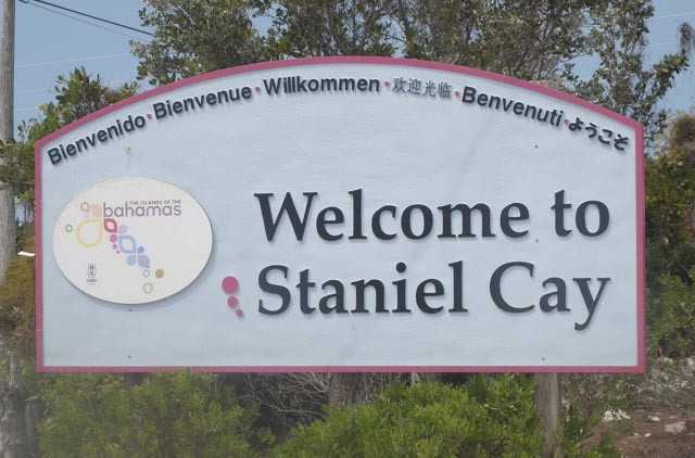
Not a major problem - simply contact the Staniel Cay Yacht Club and book a dock for a couple of days - where, when we departed on Saturday, I was assured would be readily available this week. WELL - when I called Monday afternoon for a reservation, I was informed that the marina was full - with four 100-foot motor yachts scheduled to come in (I guess size does matter??). I was advised to call back in the morning to see if there was any availability.
So Tuesday morning was to be a rather uneventful day. We spent Monday night in Black Point Harbor, with a pleasant "rock a bye baby" rolling action and awoke to a gentle breeze from the south. I planned to call SCYC first thing and then head back to Staniel, only about a 1½ hour run with the wind at our back. I would first stop at the fuel dock and then hope for a dock at the marina.
Now the fuel dock is located about 20 feet above the water and a good 12 feet above the deck of the "Lady J" - which will make docking challenging enough - but add some wind and current????
I try to do very thorough planning before entering these Exuma harbors; they are well populated with shifting shoals and there are NO channel markers. Even though we had been in and out of Staniel Cay harbor and we had the tracks of our route on the chart plotter, I still re-read one of the guidebooks to refresh my mind. I was confident that between the guidebook instructions and my previous chart plotter tracks, I would have no trouble.
WELL - I failed to realize we were entering at low tide (a 3.5 foot tidal change) and as I tried to follow the previous track, we ran aground (softly) twice trying to enter the harbor??? Finally, using the braille method, we bounced our way into the deep water that led us to the fuel dock.
I called for assistance at the "mountain-top" fuel dock and was told someone was there who would fuel us. The "someone" was an older dockhand - and I do mean "hand" - as he only had one arm!! How was Judy going to toss the line UP to him to catch and then I was to toss him the stern line - while the wind and current were pushing us away from the dock.
On our first approach, we started drifting away from the dock. Then as I was backing away for another attempt, the dockhand said that he could not service us now because a fuel tanker was about to arrive and it would take 3 hours to unload their new load of diesel and gas. . .
So we contacted the marina office again. Fortunately they did have a dock for us that we comfortably tied to. Once secured with lines and power hookup, we went right to lunch - where I immediately ordered a "Goombay Smash" and began the road to relaxation.
As mentioned earlier, trip planning in the Exumas is a never-ending unpredictable challenge. And it begins with the weather forecast. Over the next few days, a system is forecast to move in and shift the wind direction from the prevailing easterlies to west and northwest. Normally, not a big issue, but most of the Exuma anchorages such as Big Majors are well protected from the easterlies but wide open to the west and northwest winds - which are forecast to gust over 20 knots Wednesday night.
Not a major problem - simply contact the Staniel Cay Yacht Club and book a dock for a couple of days - where, when we departed on Saturday, I was assured would be readily available this week. WELL - when I called Monday afternoon for a reservation, I was informed that the marina was full - with four 100-foot motor yachts scheduled to come in (I guess size does matter??). I was advised to call back in the morning to see if there was any availability.
So Tuesday morning was to be a rather uneventful day. We spent Monday night in Black Point Harbor, with a pleasant "rock a bye baby" rolling action and awoke to a gentle breeze from the south. I planned to call SCYC first thing and then head back to Staniel, only about a 1½ hour run with the wind at our back. I would first stop at the fuel dock and then hope for a dock at the marina.
Now the fuel dock is located about 20 feet above the water and a good 12 feet above the deck of the "Lady J" - which will make docking challenging enough - but add some wind and current????
I try to do very thorough planning before entering these Exuma harbors; they are well populated with shifting shoals and there are NO channel markers. Even though we had been in and out of Staniel Cay harbor and we had the tracks of our route on the chart plotter, I still re-read one of the guidebooks to refresh my mind. I was confident that between the guidebook instructions and my previous chart plotter tracks, I would have no trouble.
WELL - I failed to realize we were entering at low tide (a 3.5 foot tidal change) and as I tried to follow the previous track, we ran aground (softly) twice trying to enter the harbor??? Finally, using the braille method, we bounced our way into the deep water that led us to the fuel dock.
I called for assistance at the "mountain-top" fuel dock and was told someone was there who would fuel us. The "someone" was an older dockhand - and I do mean "hand" - as he only had one arm!! How was Judy going to toss the line UP to him to catch and then I was to toss him the stern line - while the wind and current were pushing us away from the dock.
On our first approach, we started drifting away from the dock. Then as I was backing away for another attempt, the dockhand said that he could not service us now because a fuel tanker was about to arrive and it would take 3 hours to unload their new load of diesel and gas. . .
So we contacted the marina office again. Fortunately they did have a dock for us that we comfortably tied to. Once secured with lines and power hookup, we went right to lunch - where I immediately ordered a "Goombay Smash" and began the road to relaxation.
Comments
| Vessel Name: | Lady J |
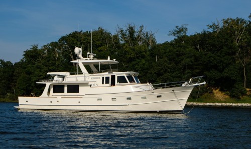
| Vessel Make/Model: | Flemming 55 |
| Hailing Port: | Herrington Harbour South |
| Crew: | Judy and Richard Seaman |
| About: | After owning Gozzard sailing vessels for over 20 years, we decided to transition to the Fleming motor yacht for our future our cruising adventures - primarily because of its ease of operating and the additional room to share our adventures with family and friends. |
Lady J's Photos - Main
 |
|
|
|
|
|
|
|
|
|
|
Our spring adventure cruising the Abacos Islands for two months in the "Lady J"
28 Photos
Created 3 April 2023
|
|
Photos from Our Unexpected Wild Morning Ride
2 Photos
Created 8 May 2016
|
|
|
Images from Shroud Cay and Warderick Wells
18 Photos
Created 28 April 2016
|
|
|
4 Days with my son Jason and son-in-law Ken to begin exploring the Exuma Islands
19 Photos
Created 13 April 2016
|
Who: Judy and Richard Seaman
Port: Herrington Harbour South
Gallery