
Sailing Sabrina
Coastal Cruising on our Hinckley Bermuda 40

18 October 2016 | Savannah, GA
12 July 2016 | Sail Harbor - Savannah, GA
11 July 2016 | Sail Harbour - Savannah, GA
10 July 2016 | Sail Harbor - Savannah, GA
10 July 2016 | Savannah, GA
09 July 2016 | Sail Harbor Marina - Savannah, GA
08 July 2016 | Shelter Cover Marina - Hilton Head Island, SC
10 June 2016 | Shelter Cove Marina - Hilton Head Island, GA
10 November 2015 | Hilton Head Island, SC
19 July 2015 | Charleston, SC ICW StM 477 MM
18 July 2015 | Winyah Bay Entrance - Georgetown SC
18 July 2015 | Georgetown, SC ICW StM 403 MM
16 July 2015 | 310 MM - Southport, NC
16 July 2015 | Southport, NC
14 July 2015 | 295 MM
10 July 2015 | Beaufort NC
09 July 2015 | ICW Mile Marker 130 near Belhaven, NC
08 July 2015 | Manteo, NC
05 July 2015
03 July 2015 | Headed to Portsmouth
Back in South Carolina
18 July 2015 | Georgetown, SC ICW StM 403 MM
James
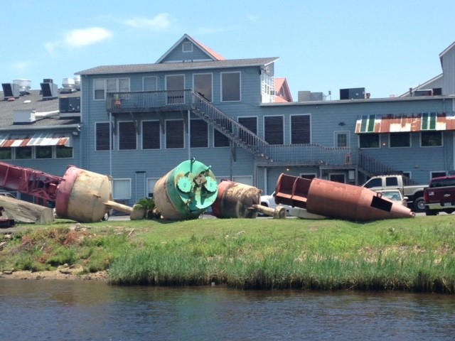
Pictured above is one of the interesting things Joe and Pat saw south of Myrtle Beach. It is the Coast Guard's maintenance yard for buoys and navigational aids. Joe pointed out how small an automobile looked compared to the buoys.
Joe and Pat left Southport, NC on Thursday and made it past Myrtle Beach, SC as planned. They anchored Sabrina near Osprey in Enterprise Oxbow near the ICW StM 375 MM. On Friday they made the short 28 miles to Georgetown, SC where they spent the afternoon browsing the local shops before moving to their overnight anchorage in Winyah Bay.
Winyah Bay is the inlet to Georgetown from the ocean and the anchorage just off the ICW positions Sabrina to make an exit from the ICW for 61 miles outside run to Charleston on Saturday, July 18. The northerly light winds will be favorable for this open ocean passage. Per Joe, some of the shallowest areas he's encountered on the ICW are between Georgetown and Charleston, and he wants to avoid traveling inside here if at all possible.
Just yesterday the Army Corp of Engineers announced that they will spend $2.4 million dollars dredging the ICW behind Sullivan's Island and Isle of Palms. A link to the article - "Corps has $2.4 million for Waterway dredging at IOP, Sullivan's."
A cruiser on the coastal waterways is always planning and taking into consideration conditions such as: weather, wind direction, water depths, tidal schedules, distance to destination, navigation markers, draw bridge and lock schedule, etc. When traveling like Joe and Pat the prudent skipper is planning ahead two to three days and developing optional plans if the weather or circumstances change. Last minute changes to cruising plans are more the norm than exception, but it's just the nature of the beast if the highest level of safety and cruising comfort are to be maintained.
Joe has done a remarkable job of cruise planning on this trip. However, I'm sure he's had a lot of help from the Admiral. Seriously, it is a skill that has to be learned to safely navigate the inland waterways!
I helped Joe develop his cruising options for the final three days of their cruise so I just happen to have it documented for sharing. Most of the time a skipper is looking at weather predictions, tidal information, and electronic charts as he/she does the mental planning.
ICW PLANNING FOR 07/17 FRIDAY
Osprey/Enterprise Oxbow Anchorage near Myrtle Beach
375 MM to Georgetown 403 MM
Total 35 miles from Osprey/Enterprise Oxbow Anchorage to Georgetown = 28
Winyah Bay Anchorage add 7 more miles from Georgetown at 403 MM
Total distance from Osprey/Enterprise Oxbow Anchorage to Winyah Bay Anchorage = 35 miles
High Tide at Winyah Bay Anchorage 10:33AM Low Tide 5:02PM
PLANNING FOR 07/18 SATURDAY
Winyah Bay Anchorage to Charleston Outside
Low Tide at Winyah Bay 5:43AM High Tide 11:18AM
Low Tide at Ft. Sumter 4:17PM
Turn south at "G5" leaving Winyah Bay Channel
Turn in Charleston Channel midway between "R16" and "R18"
Total distance from Winyah Bay Anchorage to "R16"/"R18" = 61 miles
Total distance from Winyah Bay Anchorage to Ft. Johnson Anchorage in South Channel = 68 miles
Total distance from Winyah Bay Anchorage to Wapoo Creek Anchorage = 73 miles
Winyah Bay Anchorage to Charleston Inside
Low Tide at Winyah Bay 5:43AM High Tide 11:18AM
Low Tide at Ft. Sumter 4:17PM
ICW StM 410 MM near Winyah Bay Anchorage
ICW StM 430 MMat McClelanville (20 miles from starting anchorage)
ICW StM 460 MM at Ben Swayer Bridge/Sullivan's Island (Weekend schedule opens on demand and on the hour)
ICW StM 466 MM near Ft. Johnson Anchorage in South Channel = 56 miles
ICW StM 477 MM near Wapoo Creek Anchorage = 67 miles
PLANNING FOR 07/19 SUNDAY
Charleston to Port Royal Outside
64 StM from Ft. Johnson Anchorage in South Channel Charleston to Port Royal mid-way "G15/G19"
80.5 StM from Ft. Johnson Anchorage in South Channel Charleston to Port Royal Marina
High Tide Port Royal Marina 12:13 PM
Low Tide Port Royal Marina 6:26 PM
Charleston to Port Royal Inside
ICW StM 477 MM near Wapoo Creek Anchorage
ICW StM 540 MM near Port Royal Marina
Total distance 63 StM
Ladys Island Swing Bridge opens on demand on weekends
Joe and Pat will travel the final leg of their amazing Summer Cruise to the Chesapeake arriving back in Beaufort, SC late Sunday afternoon. They will travel inside on the ICW for this portion of the trip because the Southerly winds are not favorable for the run from Charleston to Beaufort on the outside.
As Joe says, "More to Come."
Comments
| Vessel Name: | Sabrina |
| Vessel Make/Model: | Hinckley Bermuda 40 |
| Hailing Port: | Saint Simon's Island, GA |
| Crew: | Joe & Pat Brasfield |
| About: | We have been full-time liveaboards for five years and we are career professional educators. We will retire within the next five years and plan to cruise the eastern coast and Caribbean. During our 2015 summer vacation from school we plan to travel from Beaufort, SC to the Chesapeake. |
| Extra: | |
| Social: |
|
Gallery not available
Sailing Sabrina
Who: Joe & Pat Brasfield
Port: Saint Simon's Island, GA