
Sanderling's Adventures
03 May 2015
30 April 2015
27 March 2015
13 March 2015 | George Town
25 February 2015 | Exumas
12 February 2015 | Black Point, Exumas, Bahamas
12 February 2015 | Black Point, Exumas, Bahamas
02 February 2015 | North Bimini, Bahamas
24 January 2015 | Lake Sylvia, Fort Lauderdale
17 December 2014
07 December 2014
03 December 2014
20 November 2014
04 November 2014
01 November 2014
28 October 2014
28 October 2014
20 October 2014
18 October 2014 | Deltaville, VA
14 October 2014 | Great Wicomico River
Fog Happens
07 December 2014
We’ve been planning to go offshore once we made it to Florida so with the shallow waters just south of Fernandina, decent weather, and good currents it seemed like a good time to get started and take a short hop down to St. Augustine (65 miles). We got up nice and early to make the last of the ebb tide leaving the harbor. With Casey walked and a cup of coffee for Roger we were underway by a little after 7 AM. The ebb tide and the north wind created conditions on the inlet that were a good bit rougher than anticipated. We were tossed around pretty well and the bow actually took a little blue water over the top – nothing like getting the anchor cleaned off before we start. There was also a pretty thick fog that we were told would be clearing by 10 AM – not to worry – fog happens.
We made it out of the inlet in pretty good shape. A few items were tossed around down below. It doesn’t matter how much you prepare for going offshore – when you’ve been in the ICW for several weeks – there are a few things that don’t get tied down. Chrisy was not too happy with the way the trip started, but we were out and making great time. From the conversations that we overheard on the VHF it didn’t sound like there was any better visibility on the ICW.
We made great time getting down to St. Augustine and it felt great to be able to set the autopilot and just go – without worrying about shoals and bridges. The fog however wasn’t lifting as anticipated. The promise by NOAA of 10 AM was amended to 3 PM. When we arrived at the sea buoy off of St. Augustine at 2:30 PM the fog was thicker than we had seen it all day. Visibility was down to 150 yards.
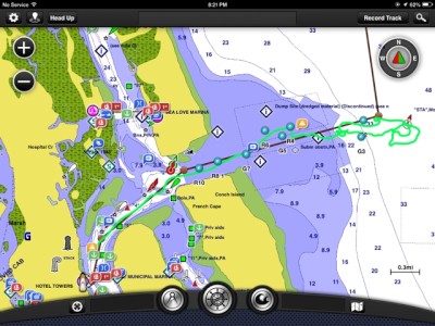
The inlet at St. Augustine is “uncharted.” Meaning that there are some shoals that move around and so the entrance buoys get moved periodically. It doesn’t make sense for them to chart the moving targets. This obviously presents some interesting navigational challenges when one can barely see the bow of the boat. Moreover, none of the markers in the inlet have radar reflectors so they don’t come up on our radar. We had done some research and knew the course in from the sea buoy that would lead us past the R2, R4, and R6 buoys. As we arrived at the sea buoy “STA” there were already two other boats there who didn’t want to head through the inlet due to the lack of visibility. Efforts to hail Towboat US to “escort” us in through the inlet were denied. I told the other boats that we knew the heading and were going to give it a shot.
We started at “STA” and went the prescribed heading of 273. After a few minutes we were able to see the first channel marker R2. What a relief. We were making progress. We kept on the heading hoping to pick up R4. No such luck. It got really shallow – the depth dropped from 36 feet to 10 feet quite quickly – so we decided to pull the plug and head back out. Fortunately we had recorded our track so we could find the “STA” sea buoy. We circled the sea buoy for 30 minutes and then a third boat joined us – a catamaran drawing 2.5 feet. They volunteered to lead the group in. I suggested to everyone that we line up side by side so that we would collectively have better vision. Some agreed – others just plowed ahead. The catamaran said they were going to proceed at 2 knots – fine with us. They take off at 5 knots and pretty soon they’re out of sight. I feel that we’re all heading too far south so I cut across the transom of the last boat and head more northerly. One of the other boats gets lifted up by a wave and decides that they’re “pulling the plug” and heading back to the STA sea buoy to start over. We keep heading north and by the grace of God manage to find R4. We’re still pretty far south of it and make a beeline for it. Once there, we’re able to get back on a 273 heading. I manage to see G5. We know that we’re in the channel, but there’s no room for mistakes on either side. We can’t see the breakwater or the shoals. We just know they’re out there. As we’re moving through the channel and spotting the buoys we’re also in contact by VHF with the two boats that headed back to the STA sea buoy and providing them with the coordinates of each of the buoys. They enter them in their GPS system and have a path through the channel.
Sometime when we’re past R4 we see a sport fishing boat heading into the harbor. One of the boats back at the STA buoy tells us that they’ve never been in the channel either; so they’re no wiser than the rest of us. They do seem to be plowing ahead, and I decide it wouldn’t be the worst thing in the world to follow them for a while. Shortly after picking up the sport fisher we’re able to see the breakwater to port – that’s a HUGE relief. All we need to do is stay about 75 feet off of the breakwater and it will lead us straight into the harbor. Somehow the catamaran that started off leading us into the channel appears on our transom.
Having made it through the most harrowing harbor entrance that we have ever had, I almost take the wrong turn – and almost run aground – actually pretty funny. I think my nerves were pretty rattled.
The next day, coincidentally, I get an email from a cruising friend from last year that has the coordinates of all the buoys in the channel. After teasing him for being a little late with the good intel, I plot the coordinates of the buoys and they line up perfectly with our track – see the photo. These coordinates were actually put to good use to help another boat through the channel a few days later, who were experiencing a similar fog.
We have been in St. Augustine since Wednesday. This is a great cruising town, wonderful marina with clean showers, great laundry facilities and a wonderful boaters lounge with wifi, a tv and great camaraderie from all the cruisers. We enjoyed a wonderful dinner with Dave and Suzy at the A1A Ale House, compliments of our children for my birthday, and a great bike ride to Villano Beach and to “see” the inlet that we miraculously came through. We attended church this morning and everyone was so welcoming. And tonight we have been invited to a “Cruisers Party” for Happy Hour where we will learn about the history of St. Augustine and meet other cruisers.
And now we are contemplating the next step…. do we press our luck and go out the inlet for more offshore fun (an overnight to Fort Pierce, Fl) or do we stay in the ICW and take 5 days to travel to Fort Pierce. What would you do??
We made it out of the inlet in pretty good shape. A few items were tossed around down below. It doesn’t matter how much you prepare for going offshore – when you’ve been in the ICW for several weeks – there are a few things that don’t get tied down. Chrisy was not too happy with the way the trip started, but we were out and making great time. From the conversations that we overheard on the VHF it didn’t sound like there was any better visibility on the ICW.
We made great time getting down to St. Augustine and it felt great to be able to set the autopilot and just go – without worrying about shoals and bridges. The fog however wasn’t lifting as anticipated. The promise by NOAA of 10 AM was amended to 3 PM. When we arrived at the sea buoy off of St. Augustine at 2:30 PM the fog was thicker than we had seen it all day. Visibility was down to 150 yards.
The inlet at St. Augustine is “uncharted.” Meaning that there are some shoals that move around and so the entrance buoys get moved periodically. It doesn’t make sense for them to chart the moving targets. This obviously presents some interesting navigational challenges when one can barely see the bow of the boat. Moreover, none of the markers in the inlet have radar reflectors so they don’t come up on our radar. We had done some research and knew the course in from the sea buoy that would lead us past the R2, R4, and R6 buoys. As we arrived at the sea buoy “STA” there were already two other boats there who didn’t want to head through the inlet due to the lack of visibility. Efforts to hail Towboat US to “escort” us in through the inlet were denied. I told the other boats that we knew the heading and were going to give it a shot.
We started at “STA” and went the prescribed heading of 273. After a few minutes we were able to see the first channel marker R2. What a relief. We were making progress. We kept on the heading hoping to pick up R4. No such luck. It got really shallow – the depth dropped from 36 feet to 10 feet quite quickly – so we decided to pull the plug and head back out. Fortunately we had recorded our track so we could find the “STA” sea buoy. We circled the sea buoy for 30 minutes and then a third boat joined us – a catamaran drawing 2.5 feet. They volunteered to lead the group in. I suggested to everyone that we line up side by side so that we would collectively have better vision. Some agreed – others just plowed ahead. The catamaran said they were going to proceed at 2 knots – fine with us. They take off at 5 knots and pretty soon they’re out of sight. I feel that we’re all heading too far south so I cut across the transom of the last boat and head more northerly. One of the other boats gets lifted up by a wave and decides that they’re “pulling the plug” and heading back to the STA sea buoy to start over. We keep heading north and by the grace of God manage to find R4. We’re still pretty far south of it and make a beeline for it. Once there, we’re able to get back on a 273 heading. I manage to see G5. We know that we’re in the channel, but there’s no room for mistakes on either side. We can’t see the breakwater or the shoals. We just know they’re out there. As we’re moving through the channel and spotting the buoys we’re also in contact by VHF with the two boats that headed back to the STA sea buoy and providing them with the coordinates of each of the buoys. They enter them in their GPS system and have a path through the channel.
Sometime when we’re past R4 we see a sport fishing boat heading into the harbor. One of the boats back at the STA buoy tells us that they’ve never been in the channel either; so they’re no wiser than the rest of us. They do seem to be plowing ahead, and I decide it wouldn’t be the worst thing in the world to follow them for a while. Shortly after picking up the sport fisher we’re able to see the breakwater to port – that’s a HUGE relief. All we need to do is stay about 75 feet off of the breakwater and it will lead us straight into the harbor. Somehow the catamaran that started off leading us into the channel appears on our transom.
Having made it through the most harrowing harbor entrance that we have ever had, I almost take the wrong turn – and almost run aground – actually pretty funny. I think my nerves were pretty rattled.
The next day, coincidentally, I get an email from a cruising friend from last year that has the coordinates of all the buoys in the channel. After teasing him for being a little late with the good intel, I plot the coordinates of the buoys and they line up perfectly with our track – see the photo. These coordinates were actually put to good use to help another boat through the channel a few days later, who were experiencing a similar fog.
We have been in St. Augustine since Wednesday. This is a great cruising town, wonderful marina with clean showers, great laundry facilities and a wonderful boaters lounge with wifi, a tv and great camaraderie from all the cruisers. We enjoyed a wonderful dinner with Dave and Suzy at the A1A Ale House, compliments of our children for my birthday, and a great bike ride to Villano Beach and to “see” the inlet that we miraculously came through. We attended church this morning and everyone was so welcoming. And tonight we have been invited to a “Cruisers Party” for Happy Hour where we will learn about the history of St. Augustine and meet other cruisers.
And now we are contemplating the next step…. do we press our luck and go out the inlet for more offshore fun (an overnight to Fort Pierce, Fl) or do we stay in the ICW and take 5 days to travel to Fort Pierce. What would you do??
Comments
| Vessel Name: | Sanderling |
| Vessel Make/Model: | Island Packet 45 |
| Hailing Port: | Jamestown, RI |
Gallery not available
Port: Jamestown, RI