D & D Nagle aboard MV DavidEllis
25 August 2022
27 May 2020 | Elfin Cove, SE Alaska
16 April 2020 | Elfin Cove, Cross Sound, Chichagof Island, SE Alaska
10 July 2019 | Elfin Cove, Alaska (or in Aussie:
18 March 2019
19 September 2017 | northbound Verney Passage, west side Gribbell Island
30 May 2017 | Photo is Meyers Chuck, north of Ketchikan AK
22 February 2017
29 August 2016 | on-the-hard, Wrangell
19 November 2015 | almost there
16 November 2015
15 November 2015
11 November 2015 | Shearwater - Bella Bella, BC
10 November 2015 | photo is approaching Bottleneck Inlet
07 November 2015
01 November 2015 | Wrangell, Alaska
17 September 2015 | Juneau to Petersburg
19 July 2015 | Wrangell > Petersburg > Tracy Arm > Juneau
28 June 2015 | Wrangell, AK (still on the hard)
03 March 2015 | Ketchikan
Last Lap
12 June 2013
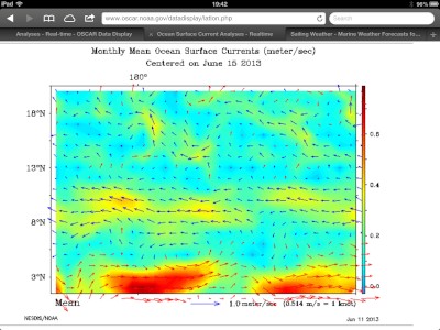
Ocean Surface Current chart from www.oscar.noaa.gov

Last bit in Majuro: Tuesday night get-together with the local cruisers; nice group of folks, many of whom came here for a few days and stayed for a few years. We thought we had fueling arranged for today, Wednesday, but it just didn't happen. We did check out with Marshall Islands Immigration, Customs and Port Authority and do our (manly) provisioning. We're hoping to fuel first thing tomorrow and get underway.
There seems no avoiding more pounding into head winds & seas; the sources we've looked at show more of the same 15-20kts 090deg from here to Hawaii. We actually are thinking to run more north than east until about 18deg N latitude to get thru the North Equatorial Current as quickly as possible, then a rhumb line to Hawaii.
But, a local cruiser, has told us looking at the Aussie Met Service, he's seeing winds 30-40 kts, north of us at 10deg N latitude!!? We're trying to schedule a discussion with our weather guy to check this out.
A half dozen of the very large tuna seiners we saw first in Pohnpei have come into the lagoon here in Majuro in the past 24hrs. They don't appear to be the same vessels as those we saw in FSM. Which suggests that tuna stocks have for to be in trouble. I have no technical knowledge about fisheries, but I can't imagine that kind of pressure doesn't have an impact.
Just finished a nice dinner with the boys at the RRE hotel, finishing up some internet, and back to Shearwater for a night's sleep before getting underway on this last leg to Hawaii.
Comments
| Vessel Name: | DavidEllis |
| Vessel Make/Model: | Diesel Duck 462 (Seahorse Marine) |
| Hailing Port: | Sebastopol, CA, USA |
| Crew: | Mike (Dave) and Dorothy Nagle |
| About: | |
| Extra: |
Gallery not available
Who: Mike (Dave) and Dorothy Nagle
Port: Sebastopol, CA, USA
