
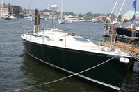
Welcome to Shazam
30 July 2013 | Alanya
06 July 2013 | 36 33.547'N:031 56.881'E, Turkey
12 June 2013 | 36 46.204'N:034 34.170'E, Turkey
31 May 2013 | 36 46.204'N:034 34.170'E, Mersin
05 June 2011 | Cartegena
31 May 2011 | Gibraltar
02 May 2011
23 August 2010 | 37 06.6'N:008 40.5'W, Portugal
25 July 2010 | 38 31.9'N: 28 37.5'W, Azores
10 June 2010 | 32 22.45'N:64 40.05.0'W, Bermuda
04 May 2010 | 18 25.6'N:064 36.6'W, British Virgin Islands
30 April 2010 | 18 25.6'N:064 36.6'W, British Virgin Islands
28 March 2010 | 18 25.6'N:064 36.6'W, British Virgin Islands
13 March 2010 | 18 25.6'N:064 36.6'W, British Virgin Islands
13 December 2009 | 18 28.8'N:064 38.1'W, British Virgin Islands
02 December 2009 | 18 25.6'N:064 36.6'W, Tortola, British Virgin Islands
27 November 2009 | 37 1.7'N:076 20.6'W, Hampton VA
18 October 2009 | 44 17.9'N:068 16.9'W, Updated Itinerary
17 August 2009 | 44 17.9'N:068 16.9'W, Mount Desert
15 July 2009 | 41 11.1'N:071 34.8'W, Block Island
The Journey North
17 August 2009 | 44 17.9'N:068 16.9'W, Mount Desert
John & Mary
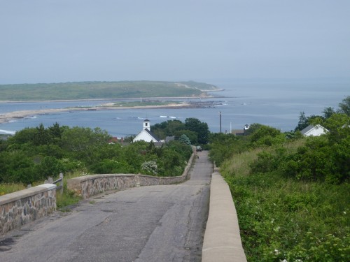
Easterly View from Cuttyhunk
After spending nearly two weeks at Block Island, hiking, exploring, catching up with some old sailing acquaintances that were taking part in Block Island Race Week, we decided to continue our journey north. We slipped our mooring just after sun rise and headed out of Great Salt Pond and into Long Island Sound, turning north along the west side of the island before rounding the green buoy "1BI" to starboard. (1BI marks the reef at the north end of the island). We then headed in a north easterly direction towards Buzzards Bay. Within an hour of our departure, the fog moved in and became denser throughout the morning. We picked up the Point Judith-to-Block Island ferry on our radar which passed a short distance behind us and then a sailing vessel which appeared like a ghost out of the fog in front of us and then disappeared back into the fog. We picked up a few other boats on radar which were probably sail boats since they were traveling at a similar rate of speed to us, and also noted a ship heading into Newport. The activity of this day seemed very quiet and even relaxed compared to our last experience with fog when transiting across the New York shipping lanes.
On our approach to Buzzard's Bay, the fog cleared and the sun came out. We could now see the island of Cuttyhunk which was our intended destination for the night. On the approach, we rounded the north side of the island before turning south and then back east to enter a small channel that took us into the Cuttyhunk pond where we picked up a mooring. After a quick snack on the boat, we launched the dinghy and headed ashore to explore. Cuttyhunk is the most eastern of the Elizabeth Islands and most densely populated with a massive year round residency of approximately two dozen people. In summer that population can increase to a few hundred. There was a small general store that carried a surprising wide range of food products and boat parts, considering its size. We passed the Cuttyhunk Historical Society and tried the door but it was firmly locked despite the notice on the door to the contrary. Oh well, that's Island Life for you. There were two small restaurants serving a variety of dishes as well as a boat and a couple of sheds down at the town docks selling fresh sea food. We decided to hike around the island where we found a wonderful view from a small hill where we could see Martha's Vineyard to the south, the mainland to the north and the rest of the Elizabeth Islands to the east. We could also look down to Cuttyhunk pond where we could see our boat at anchor. After a short walk back to the Pond, we returned to the boat to prepare for an early departure the next day.
We left Cuttyhunk soon after sunrise the next day in thick fog and headed northeast up Buzzards Bay towards the town of Marion where we planned to spend the night. Marion is located on Sippican Harbor on the north bank of Buzzards Bay just west of the Cape Cod Canal. Marion, being located so close to the canal, would allow us to time our canal transit more accurately as the current can flow very fast making it imperative that we transit the canal during weak or favorable current. We left as planned the next day in beautiful sun shine and headed for the mouth of the canal. We initially thought that we must have got our timing wrong with the current as we had a strong current against us. However, as soon as we entered the canal, the current slackened and within a few minutes started to flow with us. In no time we had a strong current pushing us through the canal.
The Cape Cod Canal was completed in 1914 and is the world's widest sea-level canal with a total length of 17.4 miles and a width of about 480 feet. We only passed one barge and a few other pleasure craft during our transit and in no time we were through the canal and out into Cape Cod Bay. We then headed north easterly across the Bay to Provincetown, located at the most northerly point on Cape Cod about 20 miles from the canal exit. There was no wind and the sea was like glass so we did not even uncover the sails but motored all the way to Provincetown. It did not seem long before we were able to pick out the Provincetown light house and a water tower which gave us a good visual to steer by. We entered the large harbor and dropped anchor close to the light house next to a sandy beach. We had just settled down for lunch when a seal came up to the boat, looked us over and continued on his way. We were a little concerned about our location for the night and whether our anchor would successfully hold in the depth of water we were in, which was over 60 feet. Since the weather forecast was for light winds, we decided not to worry and settled in for the night. However, it was not long before a thunderstorm came through producing heavy rains and winds up to 35 knots. We continuously scanned the perimeter between our boat and the neighboring boat at anchor with our 12-volt spot light throughout the storm checking to make sure our anchor was holding in the deeper water. Everything was fine as the boat held firmly. The next day called for more thunderstorms and so we decided to play it safe and take a mooring close to the town docks. We had arranged for our mail to be delivered to the Provincetown Post Office and as we had arrived on Saturday, we would now have to stay until at least Monday in order to collect it. Provincetown was a very lively and colorful place. Many of its shops, restaurants and places of entertainment were aimed at its large gay community which made it a little different from the average town. It reminded us a little of Key West.
After picking up our mail Monday morning, we returned to the boat to prepare for an early get away on Tuesday for Gloucester. The alarm clock rang at 5:30 am and we were up and ready to depart. However, after being greeted by thick fog and not even being able to see the boat on the next mooring, we decided to delay our departure. By 9:30 am the visibility had improved such that we could see across the harbor, and we decided that we would make our move. We motored out of Provincetown Harbor and around the sea wall heading north westerly towards Gloucester Harbor. As we approached the shipping lanes for Boston Harbor, the fog, as though it had been awaiting our arrival, closed in and reduced our visibility to 100 yards. We carefully monitored our radar and AIS. We picked up a few fishing boats, the Boston-to-Provincetown Ferry and a few ships that were anchored, which we assume were awaiting entry to Boston Harbor. Otherwise we had a fairly quiet trip. As we approached Gloucester Harbor the fog began to clear. We crossed the outer harbor weaving our way around the many lobster pots and headed to the inner harbor where we moored for the night in the center of the port with a few other sailboats. Gloucester is still very much a commercial fishing port which, unlike many other East Coast ports, has not transitioned over to the tourist industry. We left Gloucester at sunrise the next day and were greeted by the usual fog. We fell into the usual pattern of watching the radar and the AIS as well as keeping a good look out and sounding our fog horn whenever we picked up other vessels close to us. After running up the coast in a north easterly direction from Gloucester, we rounded Cape Ann and then headed northerly to Portsmouth across Ipswich Bay. We were unable to see either land or another vessel during the trip but picked up on several vessels around us. As we closed in on Portsmouth, we passed the Isle of Shoals but still saw nothing in the fog. We were now heading towards the mouth of the Piscataqua River, or as some Guides refer to it "The Mighty Piscataqua". It earns the title Mighty due to its fast flowing currents. It supposedly has the second fastest current for any navigable river in the U.S. which can be as strong as 10 knots at its peak. This is not the river we would have been choosing to enter in thick fog, but we have to play the hand we are dealt. We had timed our arrival, if our calculations were correct to coincide with slack water. As we were peering into the fog and trying to pick up something to confirm that we were in the right position, we heard clattering under the boat. We both turned around to notice a lobster pot appear behind us. At least we had passed clean over this one with no damaged to us or the lobster pot. We managed to see the fist red buoy "2KR" marking the entrance and headed on a bearing of 344 deg to the next buoy "R2". While we were looking for R2 the large Whaleback light house on the north bank of the river appeared out of the fog and helped confirm that we were in the correct position. We could also confirm against the next buoy that the current was indeed slack and now we could continue up stream with more confidence. The fog had now cleared enough so that we could see both Maine on the north bank and New Hampshire on the south. We continued up river for another couple of miles where we took a mooring outside the Portsmouth Yacht Club. We were pleased to have completed this trip as we were both exhausted by the concentration needed in this dense fog. We were invited ashore by some club members for snacks and drinks which we were delighted to accept. The members at the club were extremely friendly and offered us rides to the super market, marine store and even sight seeing tours around Portsmouth. That night when sleeping on the boat we were awakened by water splashing against the bow of the boat and realized that it was the ebbing current of the Piscataqua River. We were probably traveling faster through the water tied to the mooring than we had at any time during the previous two days in the fog. It's at times like this that you start wondering how secure these mooring are, how often they are overhauled, and what would happen if something gave way? Anyways, we soon fell back to sleep and we were still firmly attached to the mooring when we awoke the next day.
After spending a few days enjoying Portsmouth, we decided that rather than continue up the coast in the fog, we would sail offshore directly to Mount Desert Island, Maine. We thought that it would be a lot less nerve racking going offshore where we would experience less traffic and not have to worry about the rocky coast line. We found, what looked like a good weather window with NO FOG and a south westerly breeze for the next 24 hours that would push us nicely towards Mount Desert. We left Portsmouth at 10:00 am in a 25 knot south westerly wind and headed out into the Gulf of Maine passing the Isle of Shoals to the south and Boon Light to the north. We enjoyed some really great sailing that afternoon. The Gulf of Maine seemed to be void of shipping that day other than two small fishing boats and an AIS target heading in our direction that we picked up leaving Portland. It closed in on us and eventually passed about two hundred yards across our bow. It was a large power vessel flying a Middle Eastern flag supported by two small security vessels. Where most vessels carry a dinghy, this one carried a helicopter. Throughout the day, the wind slowly decreased but we still had plenty for a nice sail. During the evening, we noticed what looked like a water fountain on the horizon. Glancing around, we noticed more and more of these and realized that we were surrounded by whales. What a fantastic sight. As the dusk turned to night, the whales disappeared from sight. The full moon glistened across the ocean, and the cloudless night gave us plenty of light to steer by. Venus rose early the next day (around 2 am) and was so bright it also reflected a swath of light on the ocean as if to be competing with the moon. We decided that we should take turns sleeping/steering and would work in three hour shifts. However, it was such a wonderful trip that neither of us wanted to go below. We only saw two other vessels that night which was the Portland-to-Bar Harbor Ferry and a military vessel that was probably doing some training exercises as it kept going around in circles. During the night, we spotted the flashing 10 second light on Matinicus Rock which gave us something to steer by rather than just following a compass heading. We passed Matinicus Island before daylight and kept a good distance out to sea to avoid the rocky coastline and the possibility of meeting a large number of lobster pots. We continued on our north easterly path and were treated to a wonderful sunrise. We then passed the Isle au Haut and several other smaller islands to port before we could see the mountain peaks of our intended destination of Mount Desert Island. Although we were keeping several miles out to sea, the ocean was strewn with lobster pots and we had to constantly take avoiding action. It seems incredible that the lobster population can support such a massive fishing industry.
Once we had passed Baker Island just south of Mount Desert, we turned westerly along the south side of Mount Desert still weaving our way around the lobster pots and then turned north around Bear Island and into Northeast Harbor. We were met by a small boat that led us to our allocated mooring. We had finally arrived at our intended destination at 10:00 am, exactly 24 hours after leaving Portsmouth. We had enjoyed an absolutely wonderful offshore trip, and thinking back to our first offshore trip from Cape May, wondered why they could not all be like this.
Comments
| Vessel Name: | Shazam |
| Vessel Make/Model: | J130 |
| Hailing Port: | Annapolis, MD USA |
| Crew: | John & Mary Driver |
| About: | Living the Dream |
| Extra: |
Gallery not available
General Information
Who: John & Mary Driver
Port: Annapolis, MD USA