
Silkie's Journal
05 November 2008
07 September 2008
02 August 2008 | Queensland, AU
17 May 2008 | Lat 27 48'S; Long 153 26'E
26 October 2007 | Lat 23 24'S Long 159 19'E
01 September 2007 | Lat 13 17'S Long 163 54'W
01 July 2007 | Lat 17 34'S Long 149 37'W
11 May 2007 | Lat 0 45'S Long 90 18'W
13 April 2007 | Lat 08 56'N, Long 79 33'W
24 March 2007 | Lat 09 19'N, Long 80 00'W
11 February 2007 | Lat 15 50'N, Long 88 44' W
From Kingfisher Bay to Goldsmith Island
07 September 2008
September 6, 2008
From Kingfisher Bay to Goldsmith Isl. in the Whitsundays, QLD, AU
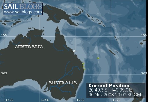
Goldsmith Island @ 20 deg. 40.28S, 149 deg. 09.00E
We arrived at Kingfisher Bay August 2, 2008 where we treated ourselves to the 4WD bus day trip on Fraser Island that we had passed by on our way south in November. The only paved roads on Fraser Island are at the resorts, all other roads are sand, and in fact the whole island is one big sand dune covered with forest and several lakes. You would not believe how these big (as in city size) buses navigate these narrow sand "roads" where "road" refers to a deep track in the sand exactly as wide at the two tire tracks of the buses, 2+ foot high sand bank tight on either side and at least 1 foot high sand between the two tracks and trees branches and trunks maybe 6 inches away from the window you are sitting beside. The windows are not openable, thankfully, because some fool would do that and lose their face to a tree.
There are about 120 dingos on Fraser Island. The resorts and the picnic areas are all fenced and protected by gates (picnic areas) or gates and "cattle guards" (resorts). The cattle guards are electrified which allows cars to pass over them but discourages dingos from walking across. A nine year old boy was killed by dingos a few years ago and other children have been attacked. There are signs all over the island warning parents to keep their kids close and not to feed the dingos.
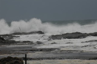
Getting back to the boat after our tour was interesting. The tide there is probably close to 8 feet and the "beach" is sand/mud and of a very gentle slope which means that if your visit ashore is any longer then 30 minutes (perhaps I exaggerate) you will either swim out to your dink or you will drag it thru the sand/mud (leaving your sandals behind in the muck in the process). Thankfully, both times we needed to go ashore at Kingfisher Bay, some very nice people offered to assist us in the dragging part, which both times amounted to a distance of at least 250-300 feet. I found that I am not as strong as I used to be.
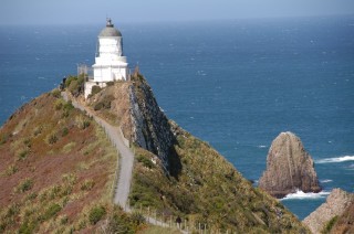
Our next stop was Bundaberg Marina where we provisioned at the Woolies, replenished our supply of reading material and had dinner with Geoff and Judy, two special Ozzies we met in Hope Island who have moved recently from Tasmania to Bundaberg. Next stop was Pancake Creek, about 6 hours up the coast, where we met up with 12th Night and spent three nights on the hook. The shelling was great along the long wide ocean beach. We took a walk up (about 30 minutes) to the lighthouse at Bustard Head, took pictures of the beautiful beaches and then decided to walk back around the point instead of back along the car track from whence we had come. Three hours later (or was it really 4 hours later?), after climbing across boulders and rocks along the shore or through the trees above the boulders and rocks along the shore we stumbled back aboard. That was the time that Jim and John came close to swimming out to retrieve the dinks from where we left them on dry sand hours before.
Next stop: Gladstone Marina where we met up with Pat and Mim Ryan, Ozzie friends from MIT days, who flew up from their home south of Melbourne. We island hopped through three beautiful anchorages including Hummocky Island and Great Keppel Island, ending up at Keppel Bay Marina, on the mainland just west of Great Keppel Island. It was a delightful week. Hopefully, one or both Ryans will join us for further sailing on our way to Darwin next year.
Our next stops included Port Clinton w/ 12th Night, a former port, now abandoned, where we spent 5 nights in the middle of NO-WHERE, far down the southern arm, only water, mud, mangroves and current around; then Hexham Island (beautiful), Digby Island (beautiful) and then Mackay Marina to wait out high winds.
While at Mackay Marina we shared a rental car with 12th Night and drove west from Mackay about 60 km to Eungella National Park which encompasses the oldest and longest stretch of subtropical rainforest in AU. We took two of the walks and looked for platypuses in Broken River but they were busy elsewhere apparently. The view from the top of the ridge eastward down the Pioneer Valley was spectacular.
This part of the QLD coast is really quite empty and doesn't have a lot of natural enbayments where boats can find protection from wind and wave. Gladstone Marina, Keppel Bay Marina and Mackay Marina are all located in large man-made basins protected from the sea by high seawalls. The tidal range at Mackay is up to 15 feet and the seawall is correspondingly high. At Keppel Bay it is only a little less. Walking from the floating docks to the facilities on dry land at Mackay is a real test of fitness: the angle is at least 30 degrees UP at low tide (and it seems like it's always low tide).
We are presently anchored in Roylan Bay at Goldsmith Island, about 29 nm north of Mackay, with two other boats and 12th Night. We are finally in the Whitsunday Islands. Our sail here yesterday was everything it should have been and last night was calm and cool. Holding is good. Shelling is good. Life is good.
'Til next time
Susan and John
S/V Silkie
From Kingfisher Bay to Goldsmith Isl. in the Whitsundays, QLD, AU
Goldsmith Island @ 20 deg. 40.28S, 149 deg. 09.00E
We arrived at Kingfisher Bay August 2, 2008 where we treated ourselves to the 4WD bus day trip on Fraser Island that we had passed by on our way south in November. The only paved roads on Fraser Island are at the resorts, all other roads are sand, and in fact the whole island is one big sand dune covered with forest and several lakes. You would not believe how these big (as in city size) buses navigate these narrow sand "roads" where "road" refers to a deep track in the sand exactly as wide at the two tire tracks of the buses, 2+ foot high sand bank tight on either side and at least 1 foot high sand between the two tracks and trees branches and trunks maybe 6 inches away from the window you are sitting beside. The windows are not openable, thankfully, because some fool would do that and lose their face to a tree.
There are about 120 dingos on Fraser Island. The resorts and the picnic areas are all fenced and protected by gates (picnic areas) or gates and "cattle guards" (resorts). The cattle guards are electrified which allows cars to pass over them but discourages dingos from walking across. A nine year old boy was killed by dingos a few years ago and other children have been attacked. There are signs all over the island warning parents to keep their kids close and not to feed the dingos.
Getting back to the boat after our tour was interesting. The tide there is probably close to 8 feet and the "beach" is sand/mud and of a very gentle slope which means that if your visit ashore is any longer then 30 minutes (perhaps I exaggerate) you will either swim out to your dink or you will drag it thru the sand/mud (leaving your sandals behind in the muck in the process). Thankfully, both times we needed to go ashore at Kingfisher Bay, some very nice people offered to assist us in the dragging part, which both times amounted to a distance of at least 250-300 feet. I found that I am not as strong as I used to be.
Our next stop was Bundaberg Marina where we provisioned at the Woolies, replenished our supply of reading material and had dinner with Geoff and Judy, two special Ozzies we met in Hope Island who have moved recently from Tasmania to Bundaberg. Next stop was Pancake Creek, about 6 hours up the coast, where we met up with 12th Night and spent three nights on the hook. The shelling was great along the long wide ocean beach. We took a walk up (about 30 minutes) to the lighthouse at Bustard Head, took pictures of the beautiful beaches and then decided to walk back around the point instead of back along the car track from whence we had come. Three hours later (or was it really 4 hours later?), after climbing across boulders and rocks along the shore or through the trees above the boulders and rocks along the shore we stumbled back aboard. That was the time that Jim and John came close to swimming out to retrieve the dinks from where we left them on dry sand hours before.
Next stop: Gladstone Marina where we met up with Pat and Mim Ryan, Ozzie friends from MIT days, who flew up from their home south of Melbourne. We island hopped through three beautiful anchorages including Hummocky Island and Great Keppel Island, ending up at Keppel Bay Marina, on the mainland just west of Great Keppel Island. It was a delightful week. Hopefully, one or both Ryans will join us for further sailing on our way to Darwin next year.
Our next stops included Port Clinton w/ 12th Night, a former port, now abandoned, where we spent 5 nights in the middle of NO-WHERE, far down the southern arm, only water, mud, mangroves and current around; then Hexham Island (beautiful), Digby Island (beautiful) and then Mackay Marina to wait out high winds.
While at Mackay Marina we shared a rental car with 12th Night and drove west from Mackay about 60 km to Eungella National Park which encompasses the oldest and longest stretch of subtropical rainforest in AU. We took two of the walks and looked for platypuses in Broken River but they were busy elsewhere apparently. The view from the top of the ridge eastward down the Pioneer Valley was spectacular.
This part of the QLD coast is really quite empty and doesn't have a lot of natural enbayments where boats can find protection from wind and wave. Gladstone Marina, Keppel Bay Marina and Mackay Marina are all located in large man-made basins protected from the sea by high seawalls. The tidal range at Mackay is up to 15 feet and the seawall is correspondingly high. At Keppel Bay it is only a little less. Walking from the floating docks to the facilities on dry land at Mackay is a real test of fitness: the angle is at least 30 degrees UP at low tide (and it seems like it's always low tide).
We are presently anchored in Roylan Bay at Goldsmith Island, about 29 nm north of Mackay, with two other boats and 12th Night. We are finally in the Whitsunday Islands. Our sail here yesterday was everything it should have been and last night was calm and cool. Holding is good. Shelling is good. Life is good.
'Til next time
Susan and John
S/V Silkie
Comments
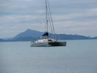
| Vessel Name: | Silkie |
| Vessel Make/Model: | CW54 Catamaran |
| Hailing Port: | Oriental, North Carolina |
| Crew: | Susan and John Fisher |
Silkie's Photos - Main
 |
 |
 |
 |
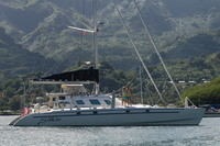
Silkie at Nuku Hiva
Who: Susan and John Fisher
Port: Oriental, North Carolina
Favorite Links
No Links Added Yet