

Silkie's Journal
05 November 2008
07 September 2008
02 August 2008 | Queensland, AU
17 May 2008 | Lat 27 48'S; Long 153 26'E
26 October 2007 | Lat 23 24'S Long 159 19'E
01 September 2007 | Lat 13 17'S Long 163 54'W
01 July 2007 | Lat 17 34'S Long 149 37'W
11 May 2007 | Lat 0 45'S Long 90 18'W
13 April 2007 | Lat 08 56'N, Long 79 33'W
24 March 2007 | Lat 09 19'N, Long 80 00'W
11 February 2007 | Lat 15 50'N, Long 88 44' W
Goldsmith Island to Hope Island Marina
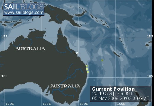
05 November 2008
November 6, 2008
The Whitsunday Islands, QLD, and New Zealand
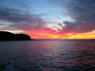
When we left Hope Island Resort Marina on July 26 headed north, our objective was to visit the Whitsunday Islands located north of Mackay, further up the Queensland coast. By September 6 we were anchored at Goldsmith Island off a beautiful crescent beach where I found many small pieces of broken coral, bleached by the sun and polished by water and sand yet showing the intricate coral architecture on the surface. I think the smaller ones will make beautiful pendants.
After Goldsmith, we stopped at Shaw Island, then Lindeman Island, then Cid Harbor on Whitsunday Island, then Nara Inlet on Hook Island. All these stops are within a few hours sail from one another over beautiful blue waters, all in sight of the mainland or other islands. This area is the chief bareboat charter area in Queensland and does a brisk business during the winter season. It is also the source of numerous humorous (true?) tales, like the guy who sails away in the charter boat and then calls back to base saying he needs a new anchor. "But I don't understand" says the guy in the office, "you left on Monday morning with two anchors." "Yeah", says the charterer, "but today is Wednesday and I need anchors for the rest of the week." (Thank you, Geoff and Judy).
We had heard lots about Cid Harbor. All good and all true. We spent two nights at Cid. I counted 50 boats, mostly sail, anchored there on the second morning and the place is so large that it was not the least crowded. There is not much beach at Cid Harbor but the walk on shore through the forest to a second small beach is wonderful. The second night there we had sundowners on the shore with about twenty other couples and singles we had never met and especially enjoyed talking with two couples originally from Holland, both of whom had come to AU at least 40 years ago. We think the USA is the land of immigrants but AU may actually do us one better.
From Cid Harbor we motored an hour to Nara Inlet, a long narrow fjord with good holding all along its length. We saw aboriginal cave paintings there and fantastic rock formations along the shore where wave action has sculpted the rocks into interesting overhanging shapes.
Our next stop was Airlie Beach, on the mainland. There must have been 200+ boats anchored in the large bay and another 150+ in the marina there. We meant to stay only one night so we dropped the anchor, no drama, except that our only access to land was at the Sailing Club, no drama again, except that even though we tied the dink as far out on their floating dock as we could get, we nonetheless found ourselves seriously mud-bound (again, as at Kingfisher Bay) a few hours later when we returned from shopping. But up at the Club, the Coke was very cold and the breeze delightful so after hanging out there for two hours, the tide came up sufficiently that we could leave the dock and get back to the boat.
Airlie Beach was as far north as we had planned to go this trip so September 16 we started back to Hope Island. Going south we encountered many whales, singles and moms with young. On two nights we heard whale songs thru the hull. We dodged several whales while underway (both sailing and motoring) and wondered if they would have moved out of our way. We had a glorious sail for about 8 hours at 9 knots and were still sailing when we came even with Great Keppel Island. Rather then stop there we continued on and sailed/motored overnight to Bundaberg. Night time sailing in this area is no problem navigation-wise but worried me whale-wise. (I know they take the crab-pots in every night in Maine waters but I'm not sure that they park the whales at sundown in Ozzie Land.) In any case, we arrived alive at Bundaberg on the 21st and caught up with Twelfth Night. We ended up staying there longer then we had planed, again due to high winds in Hervey Bay and so shared a rental car with Jim and Christine. We spent two days with them and visited the Cania Gorge and the town of 1770, seeing lots of empty hinterland, bottle trees and a beautiful rocky coast at 1770.
As we continued south over Wide Bar Bay the question was whether to stop in Mooloolaba or navigate through Moreton Bay in the dark. We decided to do Moreton Bay and were glued to our two chartplotters and our paper charts for the next several hours. Moreton Bay is quite large and contains the approaches to Brisbane. It is loaded with shoal water and the shipping channel zigs and zags and sprouts off several different branches. There are also bright shore lights which confuse the picture royally. We navigated the bay safely, managing to avoid being run over by two freighters steaming at 17-20 knots in the shipping lane and then anchored successfully in a new anchorage about 11 that night in the pitch black. Two days later we tied up to our old slip at Hope Island Resort marina and it felt like old home week.
On October 14 we flew to New Zealand (for the second time since being in Oz) and rented a camper van for 10 days (a first for us non-campers) and proceeded to have a great time driving all over the south end of the South Island, spending our nights in "holiday parks." Our van came equipped with an excellent road atlas which gives location and info about the numerous camping facilities which range from rest stops with no facilities to "top 10" parks with electricity, water, dump stations, showers and toilets, laundry rooms, kitchens and grills and (often) internet access. At one park in downtown Dunedin we paid $40 for the night, all other times we paid from 25-30$NZ. All parks were clean and well managed.
Aside from the New Zealand scenery which is unremitting and indescribably beautiful, the country is welcoming, easy to navigate and has great food to boot. One of the highlights of our trip was an overnight cruise on the Milford Mariner (about 120 feet, 65 passengers) which took us out on Milford Sound (really a fjord) on the west coast of the South Island. We left the dock at 4:30 PM and returned at 9:30 AM the next morning and in the interim saw the fjord, which is only a few miles long, saw penguins, seals and two impressive waterfalls, had a fabulously good dinner aboard, were entertained by a very funny tour guide and in the morning poked our nose out of the sound into the Tasman Sea. This area gets 21 FEET of rainfall a year and when rainfall is heavy the sides of the fjord are covered with waterfalls and the top 9 feet of the water column in the fjord is fresh. The sides of the fjord are essentially vertical, allowing the cruise ships/boats to position their bows right under the waterfall. Ya just gotta' see it to believe it.
Other high points of the trip included a vist to Larnach Castle on Otago Peninsula, just outside of Dunedin; the drive along the rugged south coast of the island; the canola fields in full bloom just west of Christchurch; a salmon farm in the hydroelectric canal below Lake Tekapo.
Could we go back to New Zealand again someday? "You betcha!"
Susan and John
S/V Silkie
The Whitsunday Islands, QLD, and New Zealand
When we left Hope Island Resort Marina on July 26 headed north, our objective was to visit the Whitsunday Islands located north of Mackay, further up the Queensland coast. By September 6 we were anchored at Goldsmith Island off a beautiful crescent beach where I found many small pieces of broken coral, bleached by the sun and polished by water and sand yet showing the intricate coral architecture on the surface. I think the smaller ones will make beautiful pendants.
After Goldsmith, we stopped at Shaw Island, then Lindeman Island, then Cid Harbor on Whitsunday Island, then Nara Inlet on Hook Island. All these stops are within a few hours sail from one another over beautiful blue waters, all in sight of the mainland or other islands. This area is the chief bareboat charter area in Queensland and does a brisk business during the winter season. It is also the source of numerous humorous (true?) tales, like the guy who sails away in the charter boat and then calls back to base saying he needs a new anchor. "But I don't understand" says the guy in the office, "you left on Monday morning with two anchors." "Yeah", says the charterer, "but today is Wednesday and I need anchors for the rest of the week." (Thank you, Geoff and Judy).
We had heard lots about Cid Harbor. All good and all true. We spent two nights at Cid. I counted 50 boats, mostly sail, anchored there on the second morning and the place is so large that it was not the least crowded. There is not much beach at Cid Harbor but the walk on shore through the forest to a second small beach is wonderful. The second night there we had sundowners on the shore with about twenty other couples and singles we had never met and especially enjoyed talking with two couples originally from Holland, both of whom had come to AU at least 40 years ago. We think the USA is the land of immigrants but AU may actually do us one better.
From Cid Harbor we motored an hour to Nara Inlet, a long narrow fjord with good holding all along its length. We saw aboriginal cave paintings there and fantastic rock formations along the shore where wave action has sculpted the rocks into interesting overhanging shapes.
Our next stop was Airlie Beach, on the mainland. There must have been 200+ boats anchored in the large bay and another 150+ in the marina there. We meant to stay only one night so we dropped the anchor, no drama, except that our only access to land was at the Sailing Club, no drama again, except that even though we tied the dink as far out on their floating dock as we could get, we nonetheless found ourselves seriously mud-bound (again, as at Kingfisher Bay) a few hours later when we returned from shopping. But up at the Club, the Coke was very cold and the breeze delightful so after hanging out there for two hours, the tide came up sufficiently that we could leave the dock and get back to the boat.
Airlie Beach was as far north as we had planned to go this trip so September 16 we started back to Hope Island. Going south we encountered many whales, singles and moms with young. On two nights we heard whale songs thru the hull. We dodged several whales while underway (both sailing and motoring) and wondered if they would have moved out of our way. We had a glorious sail for about 8 hours at 9 knots and were still sailing when we came even with Great Keppel Island. Rather then stop there we continued on and sailed/motored overnight to Bundaberg. Night time sailing in this area is no problem navigation-wise but worried me whale-wise. (I know they take the crab-pots in every night in Maine waters but I'm not sure that they park the whales at sundown in Ozzie Land.) In any case, we arrived alive at Bundaberg on the 21st and caught up with Twelfth Night. We ended up staying there longer then we had planed, again due to high winds in Hervey Bay and so shared a rental car with Jim and Christine. We spent two days with them and visited the Cania Gorge and the town of 1770, seeing lots of empty hinterland, bottle trees and a beautiful rocky coast at 1770.
As we continued south over Wide Bar Bay the question was whether to stop in Mooloolaba or navigate through Moreton Bay in the dark. We decided to do Moreton Bay and were glued to our two chartplotters and our paper charts for the next several hours. Moreton Bay is quite large and contains the approaches to Brisbane. It is loaded with shoal water and the shipping channel zigs and zags and sprouts off several different branches. There are also bright shore lights which confuse the picture royally. We navigated the bay safely, managing to avoid being run over by two freighters steaming at 17-20 knots in the shipping lane and then anchored successfully in a new anchorage about 11 that night in the pitch black. Two days later we tied up to our old slip at Hope Island Resort marina and it felt like old home week.
On October 14 we flew to New Zealand (for the second time since being in Oz) and rented a camper van for 10 days (a first for us non-campers) and proceeded to have a great time driving all over the south end of the South Island, spending our nights in "holiday parks." Our van came equipped with an excellent road atlas which gives location and info about the numerous camping facilities which range from rest stops with no facilities to "top 10" parks with electricity, water, dump stations, showers and toilets, laundry rooms, kitchens and grills and (often) internet access. At one park in downtown Dunedin we paid $40 for the night, all other times we paid from 25-30$NZ. All parks were clean and well managed.
Aside from the New Zealand scenery which is unremitting and indescribably beautiful, the country is welcoming, easy to navigate and has great food to boot. One of the highlights of our trip was an overnight cruise on the Milford Mariner (about 120 feet, 65 passengers) which took us out on Milford Sound (really a fjord) on the west coast of the South Island. We left the dock at 4:30 PM and returned at 9:30 AM the next morning and in the interim saw the fjord, which is only a few miles long, saw penguins, seals and two impressive waterfalls, had a fabulously good dinner aboard, were entertained by a very funny tour guide and in the morning poked our nose out of the sound into the Tasman Sea. This area gets 21 FEET of rainfall a year and when rainfall is heavy the sides of the fjord are covered with waterfalls and the top 9 feet of the water column in the fjord is fresh. The sides of the fjord are essentially vertical, allowing the cruise ships/boats to position their bows right under the waterfall. Ya just gotta' see it to believe it.
Other high points of the trip included a vist to Larnach Castle on Otago Peninsula, just outside of Dunedin; the drive along the rugged south coast of the island; the canola fields in full bloom just west of Christchurch; a salmon farm in the hydroelectric canal below Lake Tekapo.
Could we go back to New Zealand again someday? "You betcha!"
Susan and John
S/V Silkie
From Kingfisher Bay to Goldsmith Island
07 September 2008
September 6, 2008
From Kingfisher Bay to Goldsmith Isl. in the Whitsundays, QLD, AU
Goldsmith Island @ 20 deg. 40.28S, 149 deg. 09.00E
We arrived at Kingfisher Bay August 2, 2008 where we treated ourselves to the 4WD bus day trip on Fraser Island that we had passed by on our way south in November. The only paved roads on Fraser Island are at the resorts, all other roads are sand, and in fact the whole island is one big sand dune covered with forest and several lakes. You would not believe how these big (as in city size) buses navigate these narrow sand "roads" where "road" refers to a deep track in the sand exactly as wide at the two tire tracks of the buses, 2+ foot high sand bank tight on either side and at least 1 foot high sand between the two tracks and trees branches and trunks maybe 6 inches away from the window you are sitting beside. The windows are not openable, thankfully, because some fool would do that and lose their face to a tree.
There are about 120 dingos on Fraser Island. The resorts and the picnic areas are all fenced and protected by gates (picnic areas) or gates and "cattle guards" (resorts). The cattle guards are electrified which allows cars to pass over them but discourages dingos from walking across. A nine year old boy was killed by dingos a few years ago and other children have been attacked. There are signs all over the island warning parents to keep their kids close and not to feed the dingos.
Getting back to the boat after our tour was interesting. The tide there is probably close to 8 feet and the "beach" is sand/mud and of a very gentle slope which means that if your visit ashore is any longer then 30 minutes (perhaps I exaggerate) you will either swim out to your dink or you will drag it thru the sand/mud (leaving your sandals behind in the muck in the process). Thankfully, both times we needed to go ashore at Kingfisher Bay, some very nice people offered to assist us in the dragging part, which both times amounted to a distance of at least 250-300 feet. I found that I am not as strong as I used to be.
Our next stop was Bundaberg Marina where we provisioned at the Woolies, replenished our supply of reading material and had dinner with Geoff and Judy, two special Ozzies we met in Hope Island who have moved recently from Tasmania to Bundaberg. Next stop was Pancake Creek, about 6 hours up the coast, where we met up with 12th Night and spent three nights on the hook. The shelling was great along the long wide ocean beach. We took a walk up (about 30 minutes) to the lighthouse at Bustard Head, took pictures of the beautiful beaches and then decided to walk back around the point instead of back along the car track from whence we had come. Three hours later (or was it really 4 hours later?), after climbing across boulders and rocks along the shore or through the trees above the boulders and rocks along the shore we stumbled back aboard. That was the time that Jim and John came close to swimming out to retrieve the dinks from where we left them on dry sand hours before.
Next stop: Gladstone Marina where we met up with Pat and Mim Ryan, Ozzie friends from MIT days, who flew up from their home south of Melbourne. We island hopped through three beautiful anchorages including Hummocky Island and Great Keppel Island, ending up at Keppel Bay Marina, on the mainland just west of Great Keppel Island. It was a delightful week. Hopefully, one or both Ryans will join us for further sailing on our way to Darwin next year.
Our next stops included Port Clinton w/ 12th Night, a former port, now abandoned, where we spent 5 nights in the middle of NO-WHERE, far down the southern arm, only water, mud, mangroves and current around; then Hexham Island (beautiful), Digby Island (beautiful) and then Mackay Marina to wait out high winds.
While at Mackay Marina we shared a rental car with 12th Night and drove west from Mackay about 60 km to Eungella National Park which encompasses the oldest and longest stretch of subtropical rainforest in AU. We took two of the walks and looked for platypuses in Broken River but they were busy elsewhere apparently. The view from the top of the ridge eastward down the Pioneer Valley was spectacular.
This part of the QLD coast is really quite empty and doesn't have a lot of natural enbayments where boats can find protection from wind and wave. Gladstone Marina, Keppel Bay Marina and Mackay Marina are all located in large man-made basins protected from the sea by high seawalls. The tidal range at Mackay is up to 15 feet and the seawall is correspondingly high. At Keppel Bay it is only a little less. Walking from the floating docks to the facilities on dry land at Mackay is a real test of fitness: the angle is at least 30 degrees UP at low tide (and it seems like it's always low tide).
We are presently anchored in Roylan Bay at Goldsmith Island, about 29 nm north of Mackay, with two other boats and 12th Night. We are finally in the Whitsunday Islands. Our sail here yesterday was everything it should have been and last night was calm and cool. Holding is good. Shelling is good. Life is good.
'Til next time
Susan and John
S/V Silkie
Hope Island to Great Sandy Straits
02 August 2008 | Queensland, AU
August 1, 2008
25 deg. 35.5 S, 152 deg. 56.4 E
Queensland, Australia
In the Sandy Straits behind Fraser Island
We returned from a wonderful five week visit to the States on May 12 and found that Silkie had survived our absence in fine fiddle, tied to the dock at Hope Island Resort Marina, no drama, no worries, as they say here in Ozzie Land. We spent the next two and a half months at Hope Island finishing the generator installation and a few other items left over from our stay at Gold Coast City Marina. This time also included a two week stay in Baton Rough LA for John while he helped his company get a new contract going. However, we did manage to get away from the dock twice to drop the hook at Dux Anchorage on the west side of South Stradbroke Island, just north of here; first for three days with friends Christine and Jim on Twelfth Night and later for five days all by ourselves. What a beautiful place. S. Stradbroke is a barrier island, long and narrow, with large ocean side dunes, a windswept coast with lots of shells and an interior forest full of roos and birds. We climbed dunes; collected shells, took pictures, watched armies of little round blue crabs march across the flats to be picked off by swooping shore birds. On July 26 we finally cut the bonds that held us to Hope Island (weakened significantly by the fact that we had just about exhausted the collection at the local DVD rental store), said goodbye to some very nice fellow boaters we had met there, and started our long delayed journey to the Whitsunday Islands, some 600 nm north of Brisbane.
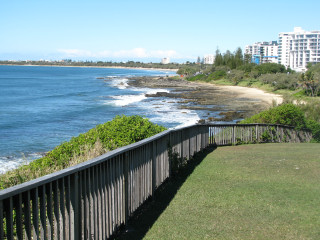
After one night anchored at Peel Island in Morton Bay, we proceeded on to Mooloolaba and took a T-head slip at Mooloolaba Yacht Club Marina, about 30 miles N of Brisbane, waiting out some high winds/seas to move out so that we could proceed north over Wide Bar Bay at the bottom of Fraser Island. We stayed at Mooloolaba last November on our way south and it was very nice to stop there again. We walked again on the boardwalk which runs through the trees above the beach for almost the entire length of the beach and enjoyed the espresso at Gloria Jean's on the esplanade above the boardwalk.
Our trip on up the coast and over Wide Bay Bar was uneventful as the seas were almost flat with only a small swell, the sun bright and the recently revised GPS waypoints for the bar crossing carefully entered into the chart plotter. Nonetheless we were surprised to see the amount of wave action that existed over the Bar. We've heard that this Bar is a real killer- -Heaven help the careless sailor who tries to cross in other then favorable conditions. We have now crossed twice with no drama.
We are presently anchored at Moonboom, about two hours north of the Bar, in the Sandy Straits, waiting in a protected spot for predicted 30 knot winds to blow by tonight. Today's chores include reading, e-mailing, writing this blog entry and making our third loop with an end to end splice in three strand nylon rope. This one really looks good. I think we're getting the knack of it.
All is well on Silkie.
Susan and John
25 deg. 35.5 S, 152 deg. 56.4 E
Queensland, Australia
In the Sandy Straits behind Fraser Island
We returned from a wonderful five week visit to the States on May 12 and found that Silkie had survived our absence in fine fiddle, tied to the dock at Hope Island Resort Marina, no drama, no worries, as they say here in Ozzie Land. We spent the next two and a half months at Hope Island finishing the generator installation and a few other items left over from our stay at Gold Coast City Marina. This time also included a two week stay in Baton Rough LA for John while he helped his company get a new contract going. However, we did manage to get away from the dock twice to drop the hook at Dux Anchorage on the west side of South Stradbroke Island, just north of here; first for three days with friends Christine and Jim on Twelfth Night and later for five days all by ourselves. What a beautiful place. S. Stradbroke is a barrier island, long and narrow, with large ocean side dunes, a windswept coast with lots of shells and an interior forest full of roos and birds. We climbed dunes; collected shells, took pictures, watched armies of little round blue crabs march across the flats to be picked off by swooping shore birds. On July 26 we finally cut the bonds that held us to Hope Island (weakened significantly by the fact that we had just about exhausted the collection at the local DVD rental store), said goodbye to some very nice fellow boaters we had met there, and started our long delayed journey to the Whitsunday Islands, some 600 nm north of Brisbane.
After one night anchored at Peel Island in Morton Bay, we proceeded on to Mooloolaba and took a T-head slip at Mooloolaba Yacht Club Marina, about 30 miles N of Brisbane, waiting out some high winds/seas to move out so that we could proceed north over Wide Bar Bay at the bottom of Fraser Island. We stayed at Mooloolaba last November on our way south and it was very nice to stop there again. We walked again on the boardwalk which runs through the trees above the beach for almost the entire length of the beach and enjoyed the espresso at Gloria Jean's on the esplanade above the boardwalk.
Our trip on up the coast and over Wide Bay Bar was uneventful as the seas were almost flat with only a small swell, the sun bright and the recently revised GPS waypoints for the bar crossing carefully entered into the chart plotter. Nonetheless we were surprised to see the amount of wave action that existed over the Bar. We've heard that this Bar is a real killer- -Heaven help the careless sailor who tries to cross in other then favorable conditions. We have now crossed twice with no drama.
We are presently anchored at Moonboom, about two hours north of the Bar, in the Sandy Straits, waiting in a protected spot for predicted 30 knot winds to blow by tonight. Today's chores include reading, e-mailing, writing this blog entry and making our third loop with an end to end splice in three strand nylon rope. This one really looks good. I think we're getting the knack of it.
All is well on Silkie.
Susan and John
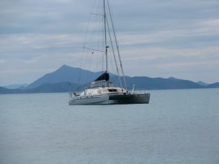
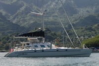
| Vessel Name: | Silkie |
| Vessel Make/Model: | CW54 Catamaran |
| Hailing Port: | Oriental, North Carolina |
| Crew: | Susan and John Fisher |
Silkie's Photos - May 08 Bundaberg to Hope Island
Silkie at Nuku Hiva
Who: Susan and John Fisher
Port: Oriental, North Carolina
Favorite Links
No Links Added Yet