
The Voyages of s/v Silverheels III
...a virtual ship's logbook, and some thoughtful (unabashed?) reflections on our sea-going experiences.
04 November 2017 | Somewhere in the Eastern Caribbean
18 October 2017 | Le Marin, Martinique in the French West Indies
25 January 2017 | Gosier, Guadeloupe
19 January 2017 | Le Gosier, Guadeloupe
19 January 2017 | Le Gosier, Guadeloupe
19 January 2017 | St Pierre, Martinique
06 January 2017
01 January 2017 | Fort Du France, Martinique
28 December 2016 | Grand Anse d'Arlet, Martinique
24 December 2016
14 November 2016 | St Anne, Martinique
06 October 2016 | St Anne, Martinique
04 October 2016
20 July 2016 | Rodney Bay, St Lucia
15 June 2016
15 June 2016
13 June 2016
13 June 2016 | Grand Anse d'Arlets
13 June 2016 | Grand Anse d'Arlets
09 May 2016 | Deshaies, Guadeloupe
Le Savane des Petrifications
20 December 2013 | St. Anne, Martinique
Lynn
When we awoke this morning to the sound of yet another round of morning rain squalls, I will confess that the idea of going for a run had very little appeal to me. Staying in bed with Ken, dry and comfy, and getting a little more sleep had a greater siren’s call on me. However, this also would allow me to go on a hike I had been contemplating, that I knew I could run part of the trail. That settled it, I stayed in bed; ‘Banyan’ and ‘Izzy R’ were on their own for baguettes this morning!
The trail that I wanted to follow was, for the most part, stuff I had done before, either running, or on previous walks with others. However, I had gone from one side or the other, and had never got to the point of seeing what was in between. Most particularly, I wanted to see “Le Savane des Petrifications”. The only things I knew about it was that it was on the trail from St. Anne to Anse Trabaud, there were signs directing hikers to it, and that the spell check on my computer didn’t like it.
Ken kindly dropped me off at about 9:30 at the dock, and I was off with hydration pack on my back and GPS watch on my wrist. I guesstimated that it would be about 20 km (12 miles). I figured about 3 hours should do it, since I was planning on doing an easy jog on some of it. The part I was doing is also the last approximately 1/3 of the Trace des Caps component of the TransMartinique Race; two friends did the 33 km trail run this year, and I am planning on doing it next year.
The first part of the trail was “old hat” to me, something I have done many times before, but after about an hour, I was into new grounds for me. As is typical of the French hiking trails, this one had educational signs and was well groomed. This was where I got more info about “Le Savane”. The area is a protected site of what was once an ancient volcano, as in 22 million years ago ancient. I assume they don’t see it as a threat now.
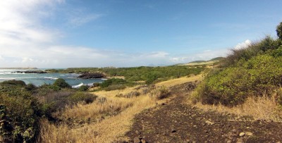
The whole area is relatively flat, at least as far as any somewhat recently volcanic island can be. Compared to most areas one sees in Martinique, this locale is quite stark, and looks like it could be found in a desert area (the mud from this morning’s rain disproved that). There is some foliage that looks to be a little less dependent of rain, such as some cacti. The soil has a tendency towards a reddish hue, making me think of a Mars-scape. Along the trail there are cairns of rocks erected, as there aren’t all that many big rocks, and fewer trees to use to mark the blazes on. The trail alternated through rocky areas, then into thick mud, and then sandier soil that gave a little better grip. The route passed close to the ocean, so in between the reddish rocks and soil, the blues and the aquamarines of the salt water stood out in sharp relief. Compared to the typical coastal trails or rainforest trails one does in the Lesser Antilles, this geological composition is not as typical to see. That is not to say that it is entirely unique, as parts of the east coast of Carriacou sprung to mind, as did the Valley of Desolation and Red Rocks in Dominica.
I continued on the trail to Anse Trabaud, which is almost directly across the island from St. Anne. I could have continued north to Cap Chevalier or even as far as Macabou, but that wouldn’t have been fair to Ken. I took the trail back inland, and arrived back in St. Anne at the dock just as my watch was telling me that I had been gone three hours, and had travelled almost 16 km (about 10.5 miles).
Now I want to see what lies north on that trail!
The trail that I wanted to follow was, for the most part, stuff I had done before, either running, or on previous walks with others. However, I had gone from one side or the other, and had never got to the point of seeing what was in between. Most particularly, I wanted to see “Le Savane des Petrifications”. The only things I knew about it was that it was on the trail from St. Anne to Anse Trabaud, there were signs directing hikers to it, and that the spell check on my computer didn’t like it.
Ken kindly dropped me off at about 9:30 at the dock, and I was off with hydration pack on my back and GPS watch on my wrist. I guesstimated that it would be about 20 km (12 miles). I figured about 3 hours should do it, since I was planning on doing an easy jog on some of it. The part I was doing is also the last approximately 1/3 of the Trace des Caps component of the TransMartinique Race; two friends did the 33 km trail run this year, and I am planning on doing it next year.
The first part of the trail was “old hat” to me, something I have done many times before, but after about an hour, I was into new grounds for me. As is typical of the French hiking trails, this one had educational signs and was well groomed. This was where I got more info about “Le Savane”. The area is a protected site of what was once an ancient volcano, as in 22 million years ago ancient. I assume they don’t see it as a threat now.
The whole area is relatively flat, at least as far as any somewhat recently volcanic island can be. Compared to most areas one sees in Martinique, this locale is quite stark, and looks like it could be found in a desert area (the mud from this morning’s rain disproved that). There is some foliage that looks to be a little less dependent of rain, such as some cacti. The soil has a tendency towards a reddish hue, making me think of a Mars-scape. Along the trail there are cairns of rocks erected, as there aren’t all that many big rocks, and fewer trees to use to mark the blazes on. The trail alternated through rocky areas, then into thick mud, and then sandier soil that gave a little better grip. The route passed close to the ocean, so in between the reddish rocks and soil, the blues and the aquamarines of the salt water stood out in sharp relief. Compared to the typical coastal trails or rainforest trails one does in the Lesser Antilles, this geological composition is not as typical to see. That is not to say that it is entirely unique, as parts of the east coast of Carriacou sprung to mind, as did the Valley of Desolation and Red Rocks in Dominica.
I continued on the trail to Anse Trabaud, which is almost directly across the island from St. Anne. I could have continued north to Cap Chevalier or even as far as Macabou, but that wouldn’t have been fair to Ken. I took the trail back inland, and arrived back in St. Anne at the dock just as my watch was telling me that I had been gone three hours, and had travelled almost 16 km (about 10.5 miles).
Now I want to see what lies north on that trail!
Comments
| Vessel Name: | Silverheels III |
| Vessel Make/Model: | Hinterhoeller, Niagara 35 Mk1 (1979) |
| Hailing Port: | Toronto |
| Crew: | Lynn Kaak and Ken Goodings |
| About: | After five summers and winters living on our boat in Toronto Harbour, we've exchanged those cold Canadian winters for Caribbean sunshine. "Nowadays, we have ice in our drinks, not under the boat." |
| Extra: |
Silverheels III's Photos - Silverheels III (Main)
Photos 1 to 14 of 14 |
1 |
 |
 |
 |
 |
 |
 |
 |
 |
 |
 |
 |
 |
 |
 |
1 |
 |
 |
The completely biased and unabashed musings from the crew of Silverheels III
Who: Lynn Kaak and Ken Goodings
Port: Toronto
SailBlogs Friends


