
Steve & Sheila's ICW Adventure
26 April 2011
25 April 2011
23 April 2011
22 April 2011 | Hampton Flats
21 April 2011
20 April 2011
19 April 2011
18 April 2011 | Alligator River Marina
17 April 2011
16 April 2011 | Spooner Creek
15 April 2011
14 April 2011 | Wrightsville Beach, NC
13 April 2011 | Myrtle Beach
12 April 2011 | Georgetown
11 April 2011 | Charleston
10 April 2011 | Just North of Beaufort, SC
09 April 2011 | Hilton Head Island, SC
08 April 2011 | Kilkenny Creek
07 April 2011
06 April 2011 | Fernandina Beach
Epilogue
26 April 2011
Steve
So, with the completion of our ICW Adventure, I can check off a major item from my "bucket list." Are we glad we did it? Yes, very much so and we recommend it for all boaters to consider. Would we do it again? Probably not. The reason is just that we have so many other things on our bucket list that we want to do, before we would consider another trip down the ICW.
[By the way, if you are new to this blog please note that the entries are listed in reverse order, with the newest entry first. If you want to read it in order, please look to the right of the screen for the partial "Table of Contents" list. To see the complete contents, go to the bottom of this list and click on "Contents". With the complete contents showing, you can click on the last entry "Delayed Start, But For Good Reason". After reading this one, click on your browser's "Back" button to return to the complete contents to select the next entry you want to read.]
My overall impression of the cruise was that it took us through a wonderful mix of everything from nature's beautiful wilderness to big cities to miles and miles of shorelines showing off people's dream homes, properties, and boats. Some modest, most not. It was a fascinating and serene journey.
We met a lot of nice people along the way - both sailors and power boaters. As experienced ICW travelers had told us, you find that you start encountering the same boats over and over, as you move along. Not really intending to or trying to, it just happens. And, after the second or third encounter - you sometimes become friends, keeping in touch by VHF and/or email. They invite you to look them up, if you pass by a place they are staying for a while.
We accepted such offers twice. For the first, we stayed a week at the Pilot House Marina in Key Largo with our neighbors and friends, Bill & Peggy, who were spending the winter there on their Block Island 40 yawl, Convergence. For the second, we stayed a week with new friends, Dale & Renie, who were spending the winter on their Monk 36 trawler, Prime Time, with many of their friends in Boot Key Harbor at Marathon on Vaca Key. We had a wonderful time with all of them!
We particularly enjoyed visiting towns and cities by water. Some new to us and some old standbys. Favorites included Oriental, NC, which was perhaps the friendliest. Charleston, SC, Fernandina Beach, FL, St. Augustine, Vero Beach, Fort Lauderdale, Coconut Grove (south Miami), Key Largo, and Marathon were also fun. And, of course, we really enjoyed the Melbourne, FL, area where our families live.
We had been told that you could not sail much on the ICW, still we were disappointed about the extent to which this was true. We motored over 90 percent of the time, including some periods (less than 20 percent) where we could unroll the jib and motor sail.
There were precious few times in the wider rivers and sounds, and our day sails in the ocean, that we could raise our full sails and turn the engine off. We enjoyed these very much.
Navigating the ICW was often a challenge. On our way south in the Fall, the days were short (we only traveled in daylight hours) and many places in the waterway had shoaled so much that we could only go through mid-tide or higher. This created timing situations that caused us to go short distances on some days just to meet these requirements.
On the way north in the Spring, we teamed up with Convergence at St. Augustine and came the rest of the way home with them. The days were longer and Bill & Peggy let us raft with them in every anchorage, when the weather was settled enough. What a wonderful difference this made! We not only were able to go further on average each day, but we were much more relaxed and really enjoyed the company.
Anchoring was generally not a problem, except for the areas that had significant tidal currents plus some opposing wind. The boat seemed to always be down wind of the anchor, but the bow seemed to always point into the current, regardless of the wind direction. This often resulted in the anchor rode lying against the side of the hull. I was concerned about wrapping the rode around our fin keel. Turning the rudder to one side seemed to help, as did the use of a 20-pound kellet on the anchor rode. However, I never got to fully prove that these techniques were always effective.
Opening bridges were generally not a problem and we found the tenders both professional and surprisingly accommodating. The exception was the area coming into Fort Lauderdale, FL, through Miami. Here, while the tenders were just as nice, there were many bridges, often closely spaced, with opening schedules obviously set for power boats that can travel at up to 10 kts between bridges. Medium sized sail boats, like ours, can only go about 7 kt on a good day and with no adverse current, so there were a few times when we missed the next opening of the next bridge because we could not go fast enough.
Each day, after we were safely anchored or in our marina slip, I had little time for relaxing or reading. The reason was the decisions I made: 1. To keep a detailed hand-written daily boat log of a lot of technical data about the operation and maintenance of the boat; 2. To write and post a nearly daily blog, as a record of our trip, for our non-sailing family and friends who were following our progress via the Internet, and for members of our sailing club; and 3. To put a detailed route for the next day's travel into our GPS Chartplotter, so all the decisions about which way to go and which side to leave a mark (they frequently switch back and forth) and avoiding all obstructions and hazards could be made in the calm of the evening. This made for much more stress-free traveling.
I'm not sorry I did these things, it was just a lot of work to keep it up, day after day.
After the second day, Sheila had mercy on me and took over most of the route planning, which was a huge effort in itself and much appreciated. She would first use the cruising guides and paper charts to look out three days or so, to see what distance we should shoot for the next day. Then, she would look for one or more nice anchorages, using Skipper Bob and other resources (good holding ground and not too much exposure to wind, wakes, and current). If she couldn't find a decent anchorage, she would find a suitable marina and call for a reservation. (We were lucky a few times that we had made advanced reservations, as some of our ICW comrades reported that they called, sometimes just hours later, and were told that the marina was booked.)
After she finished the route planning, she would carefully examine the entire route, mile by mile, for shoal areas, inlets from the ocean that often move the ICW channel around, and any other likely problem areas. She would mark these on the paper charts with colored highlighters. To aid in this step, we would consult such online resources as ActiveCaptain.com, for up to the minute information, plus local tide information for timing passage through shoal areas.
I would take Sheila's route information and hazards analysis and use it to put the next day's route into the GPS Chartplotter.
We often got underway at sunrise. This provided contingency time at the end of the day, in case we had mechanical or other problems enroute. We took turns at the helm throughout each day. When I was driving, Sheila would often sit nearby, with her highlighted paper charts in hand to cross check our progress, verify navigation marks as we passed them, and advise about any upcoming hazards.
This trip was not on Sheila's bucket list, but she fully embraced my dream of doing it, was a full partner in the whole endeavor, and had a great time, herself. I appreciated it very much.
Trip Statistics
25 April 2011
Steve
Our ICW adventure spanned six months. We left home on October 25th, 2010, and returned home April 23rd, 2011. Our initial ICW leg was to Melbourne, FL, and took five weeks, arriving November 28th. We stayed there a few days, then returned home by air for the holidays. We returned to Florida by car in January and left in the boat for the Keys on January 21. We returned from the Keys to Melbourne on February 25th. We stayed in Melbourne a week and left in the car to go home again, to check on the house and get the garden ready for Spring. In late March, we rented a car and went back to Melbourne. After a week in Melbourne, we left in the boat for home on April 1, arriving April 23rd.
In all, we were underway in the boat 64 days and had 30 lay days, for a total of 94 days on the boat. The total trip was 2,403 nautical (2,763 statute) miles. We traveled an average of 36 nautical (41 statute) miles per travel day. Our longest day was 65 nautical (75 statute) miles and our shortest was 10 (12). The most consecutive days underway without a lay day was 10. The most hours we were underway in a single day was 12 hours.
Typical cruising engine rpms was 2800 to 3000, producing about 6.3 to 6.8 kt of boat speed through the water. Flank speed was 3600 rpm, producing about 7.0 to 7.5 kt. Favorable or adverse current can cause our "over the bottom" speed to vary (higher or lower) by over 2 kt.
We used a total of 329 gallons of diesel fuel, including some for the generator and some sailing when no fuel was used, averaging 7.3 nautical mpg (8.4 statute mpg). The engine ran a total of 407 hours.
Home!
23 April 2011
Steve
We weighed anchor a 6:15 am, this morning, from Hampton Flats with 53 nautical miles to go... for HOME!
It was cool (low 60s), grey, humid and windless. What a contrast with yesterday's 30 kt! We got out into the Bay and found that the wind had come up from the south at 6 kt - exactly matching our northbound boat speed, so our full sails that we had hoisted in anticipation of a nice sail, felt nothing! This continued all the way up the Bay, until we were nearing the Piankatank river.
Then the wind began to pick up from the SW at 10-15 kt, so we turned the engine off and really sailed! As we entered the Rappahannock river on a port close reach, the wind continued increasing to SW 15-20 kt. Then, as we were half-way to the Route 3 bridge, it increased further to SW 20-25, with some higher gusts!
With this much wind, we were seriously overpowered and should have reefed the main. However, this would have taken a while to do and we were having so much fun making the boat go fast (7.5 to 8.5 kt - even touched 9 at one point!) that we just kept going and let the main luff as necessary to keep the boat on its feet. I also thought that the wind would slack off a little, once we went under the Route 3 bridge.... But, Nooooo! It kept blowing just as hard as ever.
We only got relief from sailing on the ragged edge, when we finally made a sharp starboard turn into the Corrotoman river, putting all that wind on our stern. Even on a dead run, we were still going 7.5 kt.
As we neared our dock, we dropped our sails and started the engine. We followed our traveling companions, Bill & Peggy on Convergence into our creek and yelled "Welcome Home!" as they turned off for their dock.
A few minutes later, we were tied up at our own dock.
We're home!
Not So Fast!
22 April 2011 | Hampton Flats
Steve
We broke our raft with Convergence just before dawn, this morning. We had 53 nautical miles to go to get home and we wanted to get a jump on the day. The weatherman promised E wind at 15 kt all day and this would put us on a fast starboard beam reach, all the way up the Chesapeake Bay.
It was sunny and cold (50s) and the wind made it feel even cooler. Scattered showers were expected throughout the day, but no storms. We motored out of the Hampton Flats anchorage, looking forward to a great sail with the engine off.
However, as we turned left around Fort Monroe to head out into the Bay, the wind suddenly piped up to E 20-25 kt, with gusts to well over 30 kt! And, the waves were already 3 to 4 feet. All this and we weren’t even fully out in the Bay, where conditions were surely worse!
Now, as some of you may remember, a 30 kt wind not just twice as powerful as a 15 kt wind – it is four times a strong! We realized this would not be fun, especially for Convergence, whose crew is totally exposed to the wind, waves, salt spray, and rain. So, we turned around, re-anchored and rafted.
We put all the plastic windows up around our cockpit and the four of us drank coffee and chatted in the relative comfort there, while waiting to see what the weather was going to do. After two hours, it was obvious that nothing was changing, so we scrubbed today’s sail.
By late morning, we noticed that our boats were being pretty violently rocked by big wakes from vessels traversing the main ship channel to our south. The wakes were hitting the boats right on our beam and threatening to do damage, in spite of our use of quite a few fenders, as the boats rocked severely out of phase with each other.
Our decision was to break our raft and have Wetted Bliss anchor separately, to eliminate this risk. Since this huge anchorage was all but empty of other boats, we had plenty of room to get a comfortable distance from Convergence and set our hook with plenty of scope. The anchor set well.
Tomorrow, the weatherman says the wind will still be blowing 15 to 20 kt, but will be more from the south (behind us) and the temperature will be in the 80s. We’ll see!
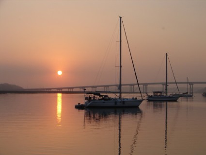
Hampton Flats
21 April 2011
Steve
We didn't set an alarm clock this morning and slept in. The wind was going to be blowing hard early from the N at 20 kt - right from the direction we have to go. However, in the afternoon, the wind is supposed to slack off to a more reasonable 15 kt. So, since we had a short distance to go today, we could afford to wait and leave after lunch. (Photo: Wetted Bliss and Convergence rafted up in Deep Creek Basin last evening.)
It was a mostly cloudy, windy, raw day, with the high only managing the low 60s. Leaving Deep Creek Basin (mile 9) for an anchorage in Hampton Flats (mile "minus" 11), just north of Norfolk's main ship channel, we were trying to time our arrival at the Gilmerton Bridge (mile 6) for its 1:30 pm opening.
We approached the bridge a little early and to our surprise, the tender hailed us to say that a barge was coming up behind us and she wanted us to go through the bridge ahead of it. Who were we to argue with logic like that?
However, we noticed that the bridge tender seemed to have trouble getting the bridge to open. It would open a little on one side, then the other, then nothing, then both sides of this double bascule finally opened fully. All this did not inspire confidence that the whole thing wasn't going to fall on us, when we went through! Nevertheless, we went through a little after 1 pm, keeping a sharp eye on those balky bascules!
About this time, our main engine's alternator stopped charging the batteries. After not finding anything obviously wrong and later consulting with Bill, we decided to wait to look into the problem until after we get home, tomorrow. In the meantime, we will use our generator to keep the batteries charged.
The Old Virginia RR bridge (mile 4) was open, but the Belt Line RR bridge at mile 3 had a train on it! Not only that, but the train was not moving!! After about 10 minutes, it started to move slowly and finally got off the bridge, so the tender could open it and allow us and a half-dozen other boats that had collected to go through.
Fifteen minutes later, we were passing by R "36" just off Hospital Point in Norfolk's Elizabeth river - the navigation mark that denotes "Mile Zero" of the ICW. No more highway-type (statute) mile markers! We are back in the real nautical world, now! (We are only about 65 nautical miles from home!)
We crossed Hampton Roads/Norfolk main shipping channel with the promised wind N at 15 kt. It was a little lumpy, but not bad. Glad we waited.
Then, we turned into Hampton Flats to anchor for the night. We rafted with Convergence well up to the north end to maximize our protection from the continuing N to NE wind overnight.
Another fine happy hour on our boat with Bill and Peggy, then a quiet evening on our respective boats. Our last night in the boat for this trip!
Deep Creek Basin
20 April 2011
Steve
We had a relatively short distance to go today from the Dismal Swamp Visitor's Center (mile 28) to our anchorage in Deep Creek Basin (mile 9). We are going to this anchorage because it is very protected - much more so than Spooner Creek - and because there is a possibility of thunderstorms this afternoon and evening. However, it should be much milder than the Spooner Creek storm.
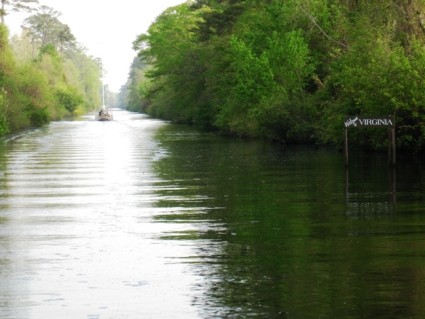
It was a beautiful sunny morning on the ICW. The temperature was balmy, with a light breeze from the south and smooth water. The waterway was breathtaking! Trees and shrubs were leafing out. Some flowers were already blooming, including more azaleas. Turtles were sunning themselves on various branches near the water. Our boat wakes were the only thing that disturbed the glassy water surface.
At mile 25 (see photo), we crossed into Virginia! We are almost home!!
At mile 11, we arrived at the Deep Creek bridge and lock. We were just a few minutes early for the 11:00am opening and there was a small bulkhead nearby that Convergence tied up to and we rafted with them. Soon, the tender drove up in his truck and yelled over to us to get back underway and he would open the bridge for us.
He did and we proceeded to motor toward the lock, while the lock tender jumped back into his truck to drive to the lock control house. He opened the lock for us and helped us tie up to the port side.
Robert, the regular tender that we met two springs ago while cruising with a group from our sailing club, was off today. Dave was the fill-in tender. He just retired from the Navy last November and has been working part time. We chatted, while the water dropped nearly 8 feet, then he opened the lock and we were out of the Swamp, headed for our anchorage just a little further up Deep Creek.
We arrived mid-day and Convergence anchored, then we rafted with them. By now, the temperature was well on its way to the forecast high in the upper 80s. The anchorage is very small, just a few acres, and completely surrounded by tall mature forest. This provides excellent wind protection for any storms this evening.
We invited Bill & Peggy for dinner on our boat, in addition to our regular happy hour. It was lemon zest cod fillets, yum!
By nightfall, there was no wind and no sign of thunderstorms! A nice, quiet evening.
| Vessel Name: | Wetted Bliss |
| Vessel Make/Model: | Hunter 36 |
| Hailing Port: | Merry Point, VA |
| Crew: | Steve & Sheila Zukor |
| About: |
Gallery not available
About Us

Who: Steve & Sheila Zukor
Port: Merry Point, VA