
Chapter Four
28 April 2019 | Petersburg, AK
16 April 2019 | Petersburg Alaska
09 October 2018 | Broughtons BC
09 October 2018 | Port McNeil BC
09 October 2018 | Ketchikan Alaska
06 October 2018 | SE Alaska
06 October 2018 | Hoonah Alaska
06 October 2018 | Sandborn Canal, SE Alaska
11 July 2018 | Eucott Bay BC
29 April 2018 | Bellingham Washington
09 December 2017 | North Pacific Ocean
05 December 2017
01 December 2017 | Eastern Pacific Ocean
01 December 2017 | San Jose Del Cabo Mexico
16 April 2017 | Eastern Pacific, April 16,2017
12 April 2017 | Eastern Pacific
Sunny Sundays on a Boat in the Marina
28 April 2019 | Petersburg, AK
Sandra Asbe | Warm and sunny
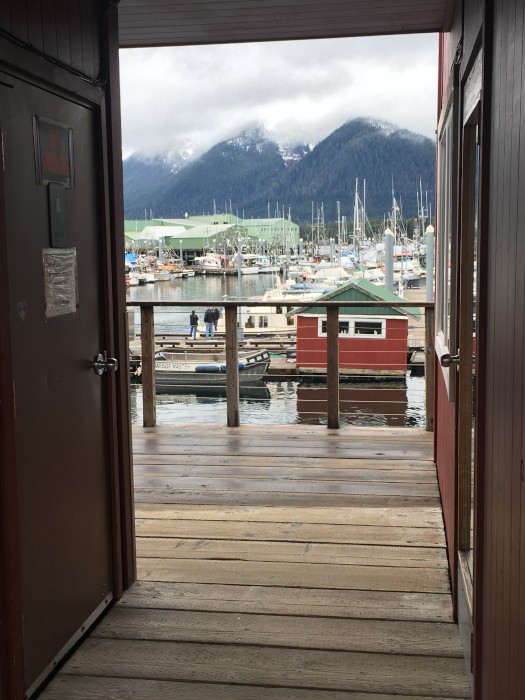
When you live on a sailboat tied up to a dock, Sunday’s are much like they are when you live in a house on land. Ours have always been chores, self care and maybe a walk and/or nap. This morning we woke up to sunshine, a special treat in SE Alaska. ☀️ Doug decided to go for a walk and I decided to roll over and sleep some more; it was 6:30 am. When he returned about 8:30 I was awake and ready to get up. Good thing because he returned bearing gifts of yumminess! A cinnamon roll for me and a maple bar for himself. One of the grocery stores in town has a bakery and they turn out delicious treats everyday of the week. We don’t indulge very often, but it’s fun when we do. After breakfast of tasty pastries and coffee, we listened to the local radio station that carries NPR programming and we both read the news on our phones, and got caught up on Facebook. Mid-morning Doug put his shoes on and went outside to putter. Much like he would have done when we had a house. I cleaned up the galley (kitchen), scrubbed the stove, made the bed, tidied up and got dressed. This took all of about 30 minutes as our space isn’t very large. Then I decided to get out my crochet hook, yarn and the books I picked up from the Library “Crochet for Beginners”. I learned to crochet when I was a girl from both my grandmothers and haven’t really done much with it. I needed some reminders and ideas. I’m sorta pondering making an afghan this summer. I’ve never done that and I think it might be rewarding. Though not sure about the amount of space I’ll need to store it. Maybe granny squares? Or patchwork squares? While I was working on this, Doug was rebuilding the wenches on the mast and chatting with passerby that often stop to say hi. Boaters and fishermen are generally quite friendly. A large percentage of them have dogs. Friendly large dogs! After awhile he came back in for a snack and a nap. I decided to be quiet and picked up my book for the 30 minutes I knew he would sleep. After he woke up we talked for awhile and he pulled some bread dough out of the fridge. He’d made the dough last week and usually makes enough for two loaves. We decided to just bake one at a time, so this was the second loaf. He got it ready to start rising in a warm place and I decided to head up to town. We needed a few things for dinner and I felt the need to move a little bit. It’s not very far from the boat, down the dock, up the ramp and up and over a few blocks to the downtown grocery store. (The bigger one with the bakery is down the road towards the airport, about a mile away. I wasn’t that energetic this afternoon.) Trips to the grocery store are frequent and not usually multi bag acquisitions. For two reasons, we are always walking and because groceries are expensive in Alaska so we are very careful to only buy what we are very sure we’ll eat. No food waste ever. Today I bought six mushrooms, a can of whole tomatoes, some hot Italian sausage, two packages of cheese (sharp cheddar and mozzarella) and a bag of chips. The latter two because they were on sale, about half off. We only buy chips when they are on sale. These were store brand and $1.89, not sure they were worth it. The cheese was $1.99 for 8 ounces, also store brand. I also bought a jar of pickles. I love pickles! Gotta have ‘em on the boat. The groceries easily fit in one bag and the total was $25. Once I got back from the store I walked across the pier that leads to the marina and saw the bench sitting in the sunshine overlooking the marina was empty. So I chose to stop and take a quiet moment to myself and just enjoy the view and the birds. Lots of Bald Eagles, Ravens and now Sandhill Cranes have returned to Petersburg from wherever they go for winter. The other water birds are fairly quiet here, but there’s nothing like hearing an Eagle cry and then look up and seeing it swoop and dive. It’s truly beautiful here and we always try to be appreciative and not take it for granted. Once I got hot, I headed back down the very steep ramp, it was low tide, and back to the boat. Doug was inside conducting an experiment on our house batteries. Even though he had topped them off with water before we left last fall, they ran dry over the winter and he’s trying a few things to see if they are going to be up to par for our summer cruising time. So far we just aren’t sure. Hopefully we don’t have to buy new batteries. For dinner I planned to make Bolognese, with Italian sausage and lots of veggies and gnocchi with fresh Parmesan cheese on top. I’d packed a Costco size hunk from Washington when we flew back to Petersburg. I have a very well stocked galley with pretty much everything I need including sharp knives, good pans and all the herbs and spices I use on a regular basis. I even have three or four types of salt and good olive oil and balsamic vinegars. I can make good food on this boat and we eat very well. Surprisingly we can get really nice produce here, we just have to watch the prices and not pay $6 for a head of leaf lettuce! As dinner was just about ready to eat, the bread was ready to bake. Guess hot bread will be our dessert tonight. I started writing this while dinner was cooking and now we’ve finished eating. Doug will wash the dishes and put the leftovers in the fridge. Then we’ll probably take a walk and come back to the boat for our evening. The usual evening consists of music from our collection or the radio and usually reading and maybe crochet for me. About 9:30 we’ll head to bed where we watch a show or two we’ve downloaded from Amazon Prime onto our iPad. Then sleeping time in our incredibly comfortable bed. Life isn’t that really that much different on a boat in the marina than it is a house on land.
Return to Petersburg
16 April 2019 | Petersburg Alaska
Doug Asbe | Cloudy, cool
Yesterday we flew back to Petersburg to begin our summer sailing season. It’s been 6 months, and we were anxious to see how the boat faired through the winter.
We had a shrink wrap cover put on, and put a de-humidifier and two space heaters inside. Both the inside and outside were dry and in good shape. Our leaky dinghy even has air in it.
Over the next several weeks we will tackle the list of known projects and a couple new ones that have cropped up.
We had a shrink wrap cover put on, and put a de-humidifier and two space heaters inside. Both the inside and outside were dry and in good shape. Our leaky dinghy even has air in it.
Over the next several weeks we will tackle the list of known projects and a couple new ones that have cropped up.
Scared Crows
09 October 2018 | Broughtons BC
Doug, mostly sunny
Arghhh. I reached my left forearm up to protect my face as I lurched down and right. A crow swept right by my head, I spotted it out of the corner of my eye.
We had left Sullivan bay marina about an hour earlier and we're heading southwest along Wells Passage. I was standing in the cockpit steering the boat.
Now three crows were circling and diving on the boat. One lands on the dinghy stored on the foredeck. Another continues to circle and dart amoung the mast and stays.
The third crow a bit further of is not a crow, but a falcon. Brown with a round head short beak and not much larger than the crows.
The crows had got caught away from the safety of the trees on shore and now were on the falcons dinner menu.
The second crow now lit on the dinghy. Both of them were pacing around with a close eye on the falcon. Apparently they determined that it was safer on the deck of a moving boat with two humans, than to take flight for the quarter mile to shore.
We watched this spectacle for 5 minutes or so until the falcon gave up. It apparently didn't like the odds of a successful hunt on a moving boat.
The crows silently rode along for another 30 minutes until we got closer to shore.
Later in the day when we launched the dinghy we noticed there was no bird poop on it. The crows held off, I guess grateful for the safe haven the boat provided.
Arctic Monkey
09 October 2018 | Port McNeil BC
Doug, mostly sunny
Arctic Monkey
We met the family from Arctic Monkey on a hike at Stewart Island in the US San Juans. Amelia was with us and we had anchored in Prevost bay, dingheyed to the public deck and hiked to the old school and museum. It is a 1 mile hike up a seldom used gravel road. The museum consists of two small one room buildings. They are painted brilliant white and located in a small grassy clearing surrounded by Douglass Fir, Maple, and Madrona trees. These buildings were once a one room schoolhouse and the living quarters for the teacher. Now they house a library and a museum collection of stories and artifacts.
The sun was out and it was warm for an April day. While Amelia and Sandra explored the museum I sat in the sun on the porch of the Library, examining the inside of my eyelids and listening to the gentle wind in the emerging leaves, birds chirping and bees gathering pollen and nectar from the miniature Daisies in the grass. In the distance I heard children’s voices. They grew louder as time passed until they burst into the clearing. Three young girls and two parents. After Looking around a bit they decided to go into the library. Mom was explaining things as they went.
Sandra and Amelia finished their examination of the museum and came over to the library porch where I sat. It’s a small library and the family got done quickly and came out. Sandra struck up a conversation. Being that we were on an island the first question usually asked is “How did you get here”? Usually answered with “By boat” Followed by what kind of boat and what Harbor are you in. Mom answered with a Garcia 45 Explorations named Arctic Monkey, and the Dad with Reid Harbor. Being unfamiliar with that boat we asked more questions and found out it was an aluminum sailboat and the young family lived on it. While Sandra and I talked with the parents Amelia sat in the grass with the kids and made necklaces and bracelets out of the little daisies.
They had spent the previous summer in Greenland then shipped their boat to the west coast in preparation to traverse the northwest passage from west to east.
We all discussed walking to the other landmark on the island, a restored lighthouse about a mile and a half away. The mom thought it might be too far for the youngest. We exchanged contact information, said our good byes and went our separate ways.
Sandra thought the family sounded familiar and recalled reading a note from Ryan Helling from Swiftsure Yachts. Once back on our boat and in cell service she looked this up. I remembered reading a magazine article about a boat designed in part by Jimmy Cornell that he used to go through the northwest passage the previous year. Arctic Monkey must be one of these boats.
A month passed. We had made our way north through the British Columbia gulf islands to Desolation Sound. Arctic Monkey popped up on our AIS. We were heading to the same anchorage at Squirrel Cove. Once the anchor had been dropped and set we launched the dinghy and motored over. One of the girls was swinging from a halyard halfway up the mast. Another girl was pushing their dinghy aside on the aft platform making room for us. They invited us aboard.
Zetty was the Mom. She had a British accent. Lou or Louey was the dad. Zoey 11, the oldest girl, Leah 8, and Rosey 6. Leah was the one up the mast. Zetty and Lou had met on an around the world cruising rally 18 years earlier. After cruising in a smaller boat they had this one commissioned to enable their desire to explore the arctic.
Logistics of living on a boat with three children is daunting to say the least. Every weekday included schoolwork. In addition the girls needed to help with the duties of cruising.
The next day the Monkeys headed out to see a set of nearby waterfalls and a fresh water lake. We dinged into town for showers and laundry. That afternoon we got back together for "Happy Hour", and had the opportunity to get to know them a bit more.
Zoey the oldest girl had a slender build long hair and bright blue eyes. At 11 she is a big help on the boat and as a sort of ring leader for the girls. She had no problem talking to us, and occasionally urged her dad to tell us a story.
Leah, the one swinging from a halyard halfway up the mast eventually came down, she was a bit shy and liked to listen to us.
Rosey was a spunky 6 year old. Bright eyes and a few missing teeth up front. She showed us her loose one.
The next day we took off going our separate ways. A week later our paths crossed in Port McNeil at the docks. This was the last real provisioning spot until Port Renfrew 200 miles North.
In the afternoons we got together with other boaters on the dock. The girls were working on a dance routine we got to be entertained once they had practiced it.
There was a beanbag game on the dock. A bag is tossed into a hole from a distance. Of course an errant throw resulted in a bag in the water. With an urgency reserved for matters of life or death Rosey exclaimed "The bag is in the water". I hopped up to help.
There was the bag, just out of reach and slowly sinking. I told her I'd hold her foot while she jumped in. That apparently was not an acceptable solution and Rosey shook her head. I went over to our boat and grabbed a boat hook. Meanwhile the bag drifted away.
As I came back Rosey thought the boat hook looked a bit short and asked with an urgent tone "Does it extend?"
It did and I extended it and handed it to Rosey. Leah grabbed the end of the pole while Rosey managed to fish out the bag just before it went under.
Ketchikan to Ketchikan
09 October 2018 | Ketchikan Alaska
Doug/Cloudy intermittent rain
Ketchikan to Ketchikan
July,17,2018
I didn't think I'd be excited to get to Ketchikan. We had been traveling North for over two months and the terrain just south of the Alaskan border was not a whole lot different than what we'd been going through in the Central BC coast. However as the GPS location inched higher toward 54 40, I found myself getting anxious. For two months we had been cruising in Canada, British Columbia from the Gulf Islands south of Vancouver past Desolation Sound, the Broughtons, the dangerous Cape Caution, the BC central Coast, Prince Rupert up to Brundige Harbor on Dundas Island just south of the Dixon Entrance marking the Canada/US Boundary.
Perhaps the thought of getting to Alaska somehow satisfied an internal goal, “Sailing to Alaska”. Once we crossed the boundary that goal will be reached. Sort of like hitting 200,000 miles on your car odometer. Or perhaps it was some sort of patriotic feeling of getting back into US waters, a place where money looked like money not game pieces. Maybe it was the thought of saving a buck a gallon on diesel compared with Canada. It could be the fact that “cheezies” a sort of extra crispy extra cheezy cheeto deep fried in butter fat, that is only found in Canada would be unavailable in Alaska, I hope we stockpiled enough. The truth likely lies closer to the fact that there would be unlimited data cell coverage in Ketchikan. Finally we would be able to catch up with the kitten photos in our Facebook feed and possibly satisify the daily reminders that our devices had not been backed up for 6 weeks.In any case we took selfies at the border and uneventfully continued our cruise to Foggy Bay. Ketchikan would have to wait until tomorrow.
It is too far to make the crossing to Ketchikan in one day. At least in a slow boat like ours. The distance between the Canadian Border and Ketchikan covers an area roughly the size of Rhode Island. US customs recognizes this and allows boaters to stop in Foggy Bay, in US waters but about 30 miles from the nearest customs offices in Ketchikan. Foggy bay consists of two bays, the first is big and deep, 100 feet and more. An inner cove is shallower and more protected from winds and waves. We idled into the inner harbor. Me at the helm watching the chart plotter and the shores, and Sandra on the bow looking for rocks in our path. At one point we had only 12 feet under the keel as we ghosted through the lagoon entrance. Inside the lagoon opened up displaying a very pleasant and secure area. We picked a spot we thought might get a bit of breeze to keep the bugs away, and dropped the anchor in 30 feet of water.
Before to long our friends in the green boat showed up, and closely behind then was Farida. The couple sailing the green boat was from Sedro Wooley. They were retired and had begun their journey the year before. We saw them first a week earlier in Windy Bay at Fjordland provincial park. We had been in the same anchorage since then a number of times. Farida is a wooden boat build along the same lines as our boat. An ancestor of our boat if you will. Before nightfall another sailboat as well as a good sized power yacht showed up for a total of five. We launched the dinghy and motored over to the green boat, Hugh and Genie. We had previouly arranged to have them over for dinner and needed to make final arrangements.
After dinner we pulled out the charts and went over the final plans to get to Ketchikan. We went over the route, then the currents and finally the tides. Sandra pointed out that this was the biggest tide of the year and the low was so low that we could not be able to leave the bay unless we left really early or really late. So we checked out sunrise time and decided to leave shortly after that, 4:30 am.
July 14,2018
We awoke to find the green boat already heading out. We made coffee, pulled anchor and were about 30 minutes behind them. The morning was overcast and for the most part calm. The motor chugged along at 1600 rpm and 4.6 knots, our normal cruising speed. We had 37 miles to cover. US customs expected us to get to Ketchikan that day. South of us was the Dixon entrance, the open water section of the inside passage that marked the Canada/US border. Ahead and to the west was Mary Island. Beyond that was Revillagigido channel and beyond that Tongass narrows and Ketchikan. For a while a favorable breeze kicked up and we raised sail and got our speed up to 6 knots.
Slowly some signs of civilation began to appear. There were navigation markers on the points approaching the channels. Then Sandras phone began beeping. It had found service and was announcing it had urgent new text messages. Apparently there was an important event as the Amazon Treasure Truck was selling T-Bone steaks in the Safeway parking lot in Edmonds.
The route took us through the Tongass Channel. A relatively thin strip of water between two islands. This was the way to town and the various vessels concentrated there. There were commercial fishing boats and sportfishing boats. There were large white power yachts, one with a helicopter on the front deck apparently waiting to ferry the owner to shore. We saw five zodiac inflatable boats. One red and four bright yellow. Each yellow boat contained four people dressed in bright yellow foul weather gear. The yellow boats followed in a row behind the red boat like ducklings behind a duck. The most conspicuous things on the water front were the cruise ships. They were 900 feet long and 12 decks high. Some had water slides on the back deck leading to an unseen pool. One had a big net I suspect caught the errant balls from a golf driving range. There were three ships in tied up to huge docks right downtown. There was room for another at the dock and before our visit ended we would see a fifth at anchor waiting for room.
Another sight to see were the float planes. There was a constant din of the 7 cylinder engines of the DeHavalin Beavers revving up to full power taking off. The pilots had to negotiate a landing spot as well as take off in the crowded channel. We got buzzed closer than we had ever before at one point with the plane barely 100 feet from the top of the mast, while the pilot glided in for a smooth landing. These are Alaskan bush pilots after all.
As we got closer to Ketchikan we began hearing the radio chatter between the harbor master and the various boats.Sandra gave them a call and arranged for a slip. Half an hour later we were tied up to the dock. After securing the boat we kicked back in the cockpit of the boat waiting for the customs officers. The clouds had cleared and the sun came out warming everything up. Both of us had stripped off the extra layers of clothing donned in the chill of the dawn air. Two officers showed up with the same last name on their chest. Sandra asked if they were bother sister, married or just a coincidence. Married. They found no issues and issued us our entry papers. We gathered our stuff and walked up to the harbor masters building to pay our bill and get information on Ketchikan.
The walk to the harbor masters building took us along the main street through town. Since the town was concentrated to a narrow strip between the mountainside and the waters edge it may have been the only street through town. It was full of cars, trucks and and an inordinate amount of those amphibious busses called Ducks. They were brightly colored and full of happy faces ready to drop back into the sea for an up close and personal encounter with the sights of the harbour. Each Duck had a name written in large cursive letters on the bow. I wonder if Jillian would be happy to see her name on a yellow duck boat. After several days in the quiet and solitude of anchoring, the noises and smells of town was a big change. We had to remind ourselves to look both ways before crossing the street.
We paid our bill and quizzed the clerks about how to find the bus, where was the best place to for a burger and how do we find the showers. Showers were important. One of the non glamorous parts of cruising is that we dont have a real shower on the boat,we also have a limited amout of water and no good way to heat it. Perhaps I will write up a review of all the public showers we have encountered. The showers at the Ketchikan marina were good, clean, hot and long enough to get all the things done. All cleaned up we caught the bus at the stop in front of the marina. I'm sure the other riders appreciated the showers as much as we did. We went downtown, about a mile and a half away. Since we had such an early start out of Foggy Bay, it was early afternoon and we had time to look around. The three cruise boats had dropped off their passengers and they were also looking around. I never knew Ketchikan was a center of diamond jewelry, but there were an inordinate number of diamond stores. I would have throught smoked salmon would be more locally appropriate.
We hopped back onto the bus and decided to ride until it got back to where we started. Since there are only 30 miles of paved road on the island we figured it would not take too long. It was a bus however and it stopped all the time. We did pass by the old Lousiana Pacific pulpmill, a state park for totem poles and the end of the road at a fishing resort called “Clover Bay”. We finished our cheap tour of the island about dinner time. Sandra had previously arranged to meet our friends from the green boat for dinner at a Mexican restaurant she discovered on Yelp.
After dinner we walked back to the marina passing the empty cruise boat docks. The place was deserted, just a few local kids riding skateboards, no cruise boats. The cruise boats shove off about dinner time so they can travel all night. That way the passengers are either eating or sleeping while the ships pass through the breathtaking fjords and islands, giving them energy to go to the diamond shops on shore or to enjoy their expensive shore excursions.
July 15, 2018
The next day we went shopping. Groceries, the boat parts store, the auto parts store (motor oil) and the hardware store.
Our plan was to circumnavigate Revillagigido (Rey-Vee-uh-hay-hay-dough) Island. This is the island Ketchikan is planted on. It's about 120 nautical miles and would likely take a week. The tour would include a couple of secluded anchorages and Misty Fjords National Park. The evening before we started we looked over the charts and found the place we would like to spend the next night. Anchorages are preferred, some sort of dock next. We also like to travel only 5 hours a day which gets us 20 to 25 miles if we are powering and 30-40 miles if we are sailing. Naha Harbour, the site of a Forest Service float and a trail to a lake, looked right. Then we checked the tides and currents. The tide raises and lowers the sea bottom 23 feet here. If you set your anchor in 20 feet of water in the afternoon, in the morning you could either be high and dry, or in 40 feet of water. All these tides generate water currents as strong as a river. They flow one direction in the morning and another in the afternoon. We like to have the current flowing in the direction we want to go. These things tell us when to depart. In this case about 10 the next morning. Some days we leave at noon, and others at the crack of dawn as soon as its light enough to travel safely, some days we may not move at all.
July 16, 2018
We were low on fuel so we stopped at the fuel dock on the way our of town. The fuel docks in Ketchikan are designed to fuel the fleet of fishing boats. These boats can carry 1000 gallons or more of fuel. Subsequently the hose was larger than the hose at an automobile filling station. The spigot looked to be about 1 inch. The attentendant asked how fast we wanted the flow. Apparently he had some sort of metering method. At full flow we could likely fill our 100 gallon tank in about a minute. Our fill hole is located inside the boat under a floor board in the galley (kitchen). I had to lift the board up, open the cap and Sandra handed me the spigot while she and I wrestled the heavy hose. There is no auto shut off mechanism. I needed to listen to the sound the filling tank makes and shut off the flow manually when it sounded like it was full. I usually have an idea of how much fuel we need and Sandra announces how much fuel we have taken as the tank fills. We have two tanks so we did this twice. Once fueled up we were on our way.
Visibility was poor on our trip to Naha. It was raining and there was a thin fog. We could usually see 3 miles or so, far enough to stay out of trouble but not far enough to see much of what we were traveling past. There was little wind so we were running the motor. At one point we passed the area near the fishing resort we rode the bus to. It is called Clover Pass. Apparently they rented boats as there were a number of these aluminum boats about 20 feet long. They all had a bright yellow stripe running at the gunwale. There was lettering “Clover Pass” as well as a number. There were enough of these boats we decided to avoid them and to go around Clover Pass and redirected our route.
We begn passing commercial fishing boats. These were trolling fishing boats, each one dragging 30 to 40 lines through the water. At any point in time 10 to 20 boats could be seen, but since our visibility was only about three miles we were seeing a new batch every hour or so.
Our VHF radio is always on when we are moving, This is to communicate with other boats out there. There is usually a business like chatter of ships announcing their intentions and coming to agreements. Channel 16 is the hailing channel, communication here should be short and to the point, like “Ocean Harvester south bound entering Tongass channel with a tow on the side and limited maneuverability, if anybody has concerns we are on one six and one three.” If a specific boat is requested you announce it three times then the name of your boat, like “Alaska Dream, Alaska Dream, Alaska Dream, this is sailing vessell Leigh Ann.” Alaska Dream will respond and you may say “it looks like we will be getting close, please advise”, They may respond with go red to red, which means we are heading towards each other and should pass each other on our port, left, side.
If more communication is necessary, you may ask to go to another channel so as not to take up the hailing channel, one six, with uncessary chatter. Two two is a channel used for longer conversations, and you may hear “Alaska Dream go to two two” They respond “going two two”.
At one point we heard a radio call, “four three, four three, four three, this is three two. We got a halibut!!!!” We suspect it was one of those Clover pass rentals talking to their buddy in another boat. I can only imagine a conversation like this
“Four Four, four four, four four this is two two”
“This is four four, go to two two”
“two two to two two”
“roger that two two, two two”
Somewhere a ballerina is smiling.
Naha is located up a narrow inlet, steep sided and heavily forested. We picked this area because it had a float at the end we could tie up to. The slope was too steep to easily anchor. It was about 20 total miles since we left Ketchikan and we chugged in after five hours of motoring in the rain and light fog. There was indeed a small float with three little 20 foot aluminum boats tied up. We found room on one side with a bit of overhang. There was a ramp and a trail.
A couple came down the trail and onto the dock. They were the adults handling a church camp some distance up the trail. We talked to them for a spell before they hopped into one of the boats and sped off. I hiked up the trail a mile or so. There was a lake just barely above sea level. Every day at low tide a river ran from the lake to the inlet, at high tide the flow stopped. About dinner time a commercial fishing boat came in and tied up to the last empty space and soon after that another commercial fisher came in and tied up to the first boat. We talked to the skipper about what he was fishing for, in this case hatchery raised dog salmon. The flesh of the dog salmon, also known as chum salmon, is used for bait, and the roe is sold to the Japanese market.
Before we went to bed we looked over the charts and guidebooks and decided on our next destination and the time we should leave.
July 17, 2018
The next morning it was still raining but the fog had lifted. Yes Bay was our destination, again about 20 miles away. We didn't have any unusual currents to worry about. We passed the last commercial fishers and soon had the waters to ourselves.
Yes Bay lies at the northwest end of the Behm Canal and is on the mainland. There are no roads and the only access is either by boat or float plane. Halfway up Yes Bay is a resort and small dock. Our anchorage would be about a mile past the resort. We motored slowly up the smooth waters of the bay in early afternoon. Our electronic charts were not working correctly and we were hoping that we could get some cell or wifi coverage while we passed the resort. This would allow us to do some updates and investigations. No luck. We dropped anchor in glassy waters and spent the rest of the afternoon and evening resting quietly in a light drizzle.
July 18, 2018
Fitzgibbon Cove was our destination the next day. To get there we had to go through the Behm Canal Narrows, a place where the channel gets very small and the currents can run strong. We needed to time our departure to take advantage of the current and hit the narrowest part at slack tide, the time when the current was changing from one direction to the other. When we left the next morning there was a light breeze and we were able to raise the sails for a couple hours. The narrows proved to be a non event, seemingly not quite as narrow nor filled with treacherous currents and whirpools. Timing is everything.
Fitzgibbon Cove ended up being a good place to anchor. Although there was a large log floating around with the incoming and outgoing tide. It had a significant rootball rising 8 feet or so above the water. This would not do us any good if it bumped into the boat in the middle of the night.
July 19, 2018
The Misty Fjords National Park begins at the north end of the Behm Canal near Fitzgibbon Cove. This is a place of glacier carved inlets and deep water. Fortunately for us the weather was changing and we expected blue skies and sunshine. The Unuk River pours into the canal just north of Fitzgibbon Cove. It is a river of glacier meltwater and is a milky green color. As the glaciers grind along they pulverize the rock into a fine powder that doesn't settle quickly. The waters of the canal were milky where this river entered. Walker Bay is perhaps the most striking of the Misty Bay Fjords. It was our next destination. The Forest Service maintains a mooring ball halfway up the inlet, we hoped to tie up to this. Another boat beat us to it. We heard that this boat remained tied to the ball for weeks on end. We continued on to the head of the bay.
The water was glassy and dark. Birds, white gulls and gray murrelets skurried out in front of the boat. The hillsides rose nearly vertically 4000 feet to alpine meadows high above. This area gets over 12 feet of rain per year giving ample water to grow trees where ever they can get a root hold. Waterfalls cascade down the mountains. The head of the bay has two different streams each creating a flat meadow. At the tideline there is a ribbon of green grass. It was low tide and the tidelands were exposed showing the mix of sand mud and rocks. We approached the tidelands slowly. The depth went from 500 feet to 200 then quickly to 100 as we put the boat in reverse. The underwater debris from the stream drops off at a 45 degree angle, meaning moving foreward another 100 feet would put us aground. We dropped the bow anchor in 70 feet of water. I prepared the stern anchor and line. Using the dinghy I took the anchor to the tidelands, carried it up land 200 feet and set it firmly in the mud. Sandra cinched up the line pulling the boat securely between the two anchors and setting the bow anchor. Now we could relax and enjoy the setting we were in.
The tide was rising and soon the anchor I had set by hand in the mud was covered with 10 feet of water.The sun we had enjoyed in the morning had turned to a light rain. As I watched the shore a brown bear emerged from the bushes and began feeding in the tideline grass. They eat a lot of grass if the fish are not running in the streams. The bear ate and walked around for a couple of hours before going back into the bushes and trees of the valley.
We spent the night there, but had to leave the next morning heading to Rudyard Bay and the famous Punchbowl. I took the dinghy and retrieved the stern anchor which was underwater, returned to the boat, pulled the bow anchor and we headed out under power.
July 20,2018
The trip to Rudyard Inlet was largely uneventful, except for when we passed by the Chickamin River. This is a glacial river and the water was milky green. I tasted it also and it was fresh. The fresh water from the river was floating on top of the denser salt water beneath.
Rudyard Bay is located about 30 miles from Ketchikan. It has a striking inner bay called Punchbowl with a 3000 foot granite cliff reminescent of Yosemite valley. Being close to Ketchikan it is the location of choice for float planes and excursions from the various cruise boats. Punchbowl is about two miles long and nearly as wide. At the far end is a green strip of grass at the tideline, a stream and a forest Service Float we managed to tie up to. While we got settled in at the mooring ball a group of kayakers, about 12 in all, rowed up to the shoreline and proceded to unload gear preparing to camp for the night. There is a trail on shore leading to a lake. I launched the dinghy and rowed to shore looking for the trail. In the process I met the kayakers, another group in a powerboat, had a long walk along the tidelines, I rowed back to our boat and finally to the trailhead. The tidelands here had the unmistakable markings of a large critter walking around. There was horse sized skat all over and places where something the size of a horse had layed down. With a steady stream of talking and/or singing I headed up the trail to the lake. I didn's see a bear or get eaten by one either.
July 21,2018
Punchbowl to Shoalwater
Shoalwater was our next destination. It ended up being 30 miles from the spectacular Punchbowl location. To get there we headed south through the Behm channel. The only tricky part was the depth of the channel to get into the anchorage. The charts indicated that the water would be about 12 feet deep at the tide we were at. As we inched through the shallow areas the depth sounder got as shallow as 9 feet, leaving only 3 feet under our keel. Inside the narrow bay we set anchor in about 40 feet of water. We were the only boat there. The only indication of any other human presence was a small Forest Service cabin tucked into the trees along shore. The wind started picking up and we had our all our 165 feet of chain and a hundred feet of nylon braid laid out. Before the sun set another five boats had sought shelter in the calm waters of the bay. Each one crept slowly through the shallow entrance. One boat had a dog. Once settled at anchor, the dog and his master hopped in their dinghy and headed out to the nearest shore. The dog anxiously standing at the front of the dinghy like a hood ornament as they sped along. We spoke them once the dog had finished his business. They were traveling with one of the other boats. It was owned by the mans brother. He was from Gig Harbor. He had painstakenly rebuilt his boat over the past 30 years. It was his lifelong dream to be there. The wind blew at twenty knots through out the night. We were all safe.
July 22,2018
There were no good anchorages between Shoalwater and Ketchikan so we got up early and headed out at high tide (remember the shallow entrance to the harbor?). It was 43 miles to Ketchikan, almost twice as long as we usually like to go. With no wind we motored along in a light drizzle and clouds. In the distance I could see a float plane. It was headed our direction, not unlikely since we were in the flight path between Misty Fjords and Ketchikan. This one was flying low, just off the water. About a half mile away the lights on the wing began flashing and the plane wavered a bit as if waving hello. It was our new friend Sol, who flew float planes on the weekends. He buzzed close to us on his way out and again coming back.
As we got closer to Ketchikan there were more and more boats. Both of us had to keep a sharp eye out to stay out of trouble. We returned to the same marina in Ketchikan that we had stayed at before, “Bar Harbor” and were even assigned to the same row of slips. It was nice to be in a familiar place.
Sinbad
06 October 2018 | SE Alaska
Doug/Cloudy intermittent rain
Sinbad is a 120 foot luxury yacht, white hull, multiple decks, it likely has a hot tub. We first saw them on our AIS as we anchored in Lowe inlet along the Grenville canal just South of Prince Rupert. We passed them as they sat quietly at anchor. We entered the narrow waters of the canal and turned north. A few minutes later Sinbad made the same turn and headed north up the channel behind us. In addition to the obvious glitz, and suspected luxuries on board, they also sported some sizable engines and appropriately sized propellers. These were gunned and the boat appeared to be attempting to reach a plane like a ski boat pulling up a champion slalom skier. The boat roared past making a wake with a nice curl my surfer friends could ride for miles. I turned our boat so the wake would hit us from straight astern taking advantage of our pointy aft. Our friends in the green boat were just behind us and were already bobbing wildly back and forth. The wake hit us and we slid down the face. I was reminded of the day a year before at Cape Mendicino with 40 knot winds and 15 seas.
By the time we quit bobbing Sinbad was well up the channel, the waters of the canal continued to splash as the echo and re echo waves bounced around.
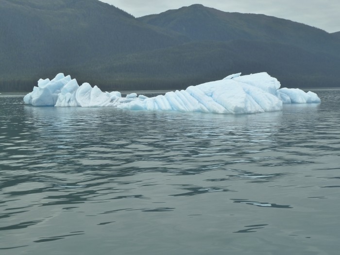
As we entered Tracy Arm inlet almost two months later we heard our radio come alive. "Securite this is Sinbad approaching Tracy Arm bar, any concerned vessels please comment". Sandra got on the radio and said we would be entering the narrow bar channel at about the same time. There was a four knot current pushing us through the channel and there were RV sized icebergs all over. The Sinbad Captain responded that he saw us and would take the corner wide leaving us with ample room. To his word he left us with ample room, but was gunning his engines to make it through the Current he had to fight against. A familiar surf-able wave replete with curl stretched out behind the yacht. We recognized the situation and steered into the wake as the icebergs rocked back and forth.
We decided Sinbad is Arabic for "Makes big Wake"
By the time we quit bobbing Sinbad was well up the channel, the waters of the canal continued to splash as the echo and re echo waves bounced around.
As we entered Tracy Arm inlet almost two months later we heard our radio come alive. "Securite this is Sinbad approaching Tracy Arm bar, any concerned vessels please comment". Sandra got on the radio and said we would be entering the narrow bar channel at about the same time. There was a four knot current pushing us through the channel and there were RV sized icebergs all over. The Sinbad Captain responded that he saw us and would take the corner wide leaving us with ample room. To his word he left us with ample room, but was gunning his engines to make it through the Current he had to fight against. A familiar surf-able wave replete with curl stretched out behind the yacht. We recognized the situation and steered into the wake as the icebergs rocked back and forth.
We decided Sinbad is Arabic for "Makes big Wake"
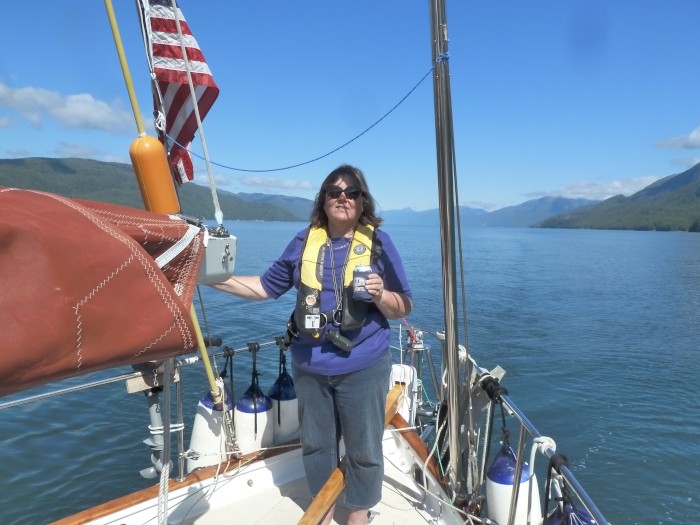
| Vessel Name: | Leigh Ann |
| Vessel Make/Model: | Alajuela 38 |
| Hailing Port: | Bellingham, Washington |
| Crew: | Sandra and Doug Asbe |
| About: | |
| Extra: |
Gallery not available
Chapter Four

Who: Sandra and Doug Asbe
Port: Bellingham, Washington