Life Afloat on SV Light Reach Two Sailors and a Sea Dog
05 November 2021 | Enroute to Stuart
04 November 2021
03 November 2021 | Indiantown
24 October 2021 | Indiantown
09 September 2021 | Treasure Coast Florida
07 August 2021 | Finger Lakes region NYS
28 July 2021 | South Jersey Shore
14 May 2021 | St Lucie River
09 May 2021 | Stuart Fl
05 April 2021 | Stuart Florida
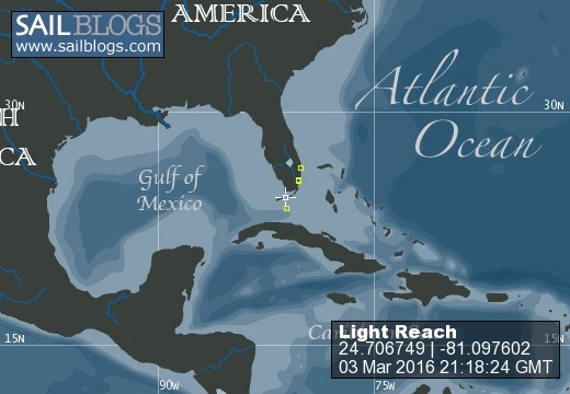
02 March 2021 | Stuart Fl
01 February 2021 | Stuart
30 January 2021 | Boca Raton
29 January 2021 | Stuart Fl
21 January 2021 | Boynton
19 January 2021 | Stuart
29 December 2020 | Stuart F:
25 December 2020 | Sampe as we have been Ho Ho Ho
17 December 2020 | Stuart
16 December 2020 | Sunset Bay Stuart
Velcroed to Boot Key
23 March 2017 | Mooring P2 Boot Key Harbor
Sally front headed our way
Still here in Boot Key with another front moving in tonight. Winds are expected to be in the 25 to 30 knot range. We brought in more water for the front tank this morning in an attempt to keep it nearly full. The back tank is connected to the water maker and for the most part we have been using the water maker to keep that tank somewhat full. We managed to overflow it the other day and wet the bunk down. It's venting system is a bit conflugled by a filter we have in line between the vent and the tank. Not a terrible disaster and we had good sunny weather to dry out the mattress. We have to run the water maker every 5 days to keep it in commission and not bugger up the filters and membranes.
We continue to look for a good weather window to make the jump. Meanwhile we have been going through the perishables we stocked in, so yet another trip to the market will be in our future before we leave.
Monday night we had a cook out with some fellow cruisers in the harbor. The crews from Maggie M, Rainbows End, Kittywake and one other boat whose name is escaping me. Maggie M were the organizers. We took our dingys to the beach and cooked out overlooking Hawks channel. We ended the evening with a sing along to a song Chris (Maggie M) had written. What a hoot. The captain didn't actually sing but he did seem to enjoy it. It was a great meal with lots of laughs and stories.
Last night we spent a nice happy our on Moore to Sea ( Jill and Randy) along with Jim from Windarra and his sweet pooch Ali. Being velcroed to Boot Key hasn't been at all painful.
I've been trying without much success to copy our charts from the new chart plotter to an SD card so I can use Garmin Homeport on the PC to do routes while we are underway. Right now I do the routes on the IPad and then send them via e-mail so that I can download them to the computer and then onto an SD card to transfer to the chartplotter. A rather convoluted and onerous process, one that requires internet or cell phone access once we are underway. Where we are going that will not always be available. Manually entering the way points into the plotter is doable but a tad error prone, not to mention time consuming. At any rate working with charts seems to take up a good deal of my time. We'll need the computer to store the routes as the plotter can only hold 100 routes and we'll be using more than that as we travel between the multiple islands of the Bahamas. We do have the paper Explorer charts and the Maptech version on board. And we have the Bad Elf for the IPad that alows us to use it as a chart plotter. Redundancy is a good thing to have on board!
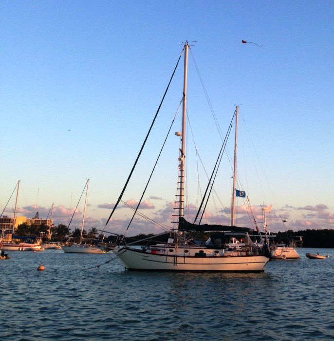
The picture is of Maggie M, she is on one of the mooring balls adjacent to us. If you look closely you will see a kite being flown by one of the boats just beyond her.
We continue to look for a good weather window to make the jump. Meanwhile we have been going through the perishables we stocked in, so yet another trip to the market will be in our future before we leave.
Monday night we had a cook out with some fellow cruisers in the harbor. The crews from Maggie M, Rainbows End, Kittywake and one other boat whose name is escaping me. Maggie M were the organizers. We took our dingys to the beach and cooked out overlooking Hawks channel. We ended the evening with a sing along to a song Chris (Maggie M) had written. What a hoot. The captain didn't actually sing but he did seem to enjoy it. It was a great meal with lots of laughs and stories.
Last night we spent a nice happy our on Moore to Sea ( Jill and Randy) along with Jim from Windarra and his sweet pooch Ali. Being velcroed to Boot Key hasn't been at all painful.
I've been trying without much success to copy our charts from the new chart plotter to an SD card so I can use Garmin Homeport on the PC to do routes while we are underway. Right now I do the routes on the IPad and then send them via e-mail so that I can download them to the computer and then onto an SD card to transfer to the chartplotter. A rather convoluted and onerous process, one that requires internet or cell phone access once we are underway. Where we are going that will not always be available. Manually entering the way points into the plotter is doable but a tad error prone, not to mention time consuming. At any rate working with charts seems to take up a good deal of my time. We'll need the computer to store the routes as the plotter can only hold 100 routes and we'll be using more than that as we travel between the multiple islands of the Bahamas. We do have the paper Explorer charts and the Maptech version on board. And we have the Bad Elf for the IPad that alows us to use it as a chart plotter. Redundancy is a good thing to have on board!
The picture is of Maggie M, she is on one of the mooring balls adjacent to us. If you look closely you will see a kite being flown by one of the boats just beyond her.
Comments
| Vessel Name: | Light Reach |
| Vessel Make/Model: | Pacific Seacraft 37 |
| Hailing Port: | Annapolis Md |
| Crew: | Scott and Sally and missing our CSO India the wonder Schnauzer she sails on in our hearts |
| About: | |
| Extra: | "I must go down to the sea again, to the lonely sea and the sky; and all I ask is a tall ship and a star to steer her by." John Masefield |
Light Reach's Photos - Main
 |
August 2015 visit to Keuka Lake (New York Finger Lakes)
1 Photo
Created 2 September 2015
|
S/V Light Reach
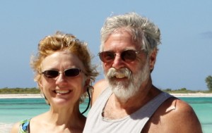
Who: Scott and Sally and missing our CSO India the wonder Schnauzer she sails on in our hearts
Port: Annapolis Md