Life Afloat on SV Light Reach Two Sailors and a Sea Dog
05 November 2021 | Enroute to Stuart
04 November 2021
03 November 2021 | Indiantown
24 October 2021 | Indiantown
09 September 2021 | Treasure Coast Florida
07 August 2021 | Finger Lakes region NYS
28 July 2021 | South Jersey Shore
14 May 2021 | St Lucie River
09 May 2021 | Stuart Fl
05 April 2021 | Stuart Florida
02 March 2021 | Stuart Fl
01 February 2021 | Stuart
30 January 2021 | Boca Raton
29 January 2021 | Stuart Fl
21 January 2021 | Boynton
19 January 2021 | Stuart
29 December 2020 | Stuart F:
25 December 2020 | Sampe as we have been Ho Ho Ho
17 December 2020 | Stuart
16 December 2020 | Sunset Bay Stuart
Gulf Stream Crossing
02 April 2017 | Northwest Providence Channel
Sally warm and hazy
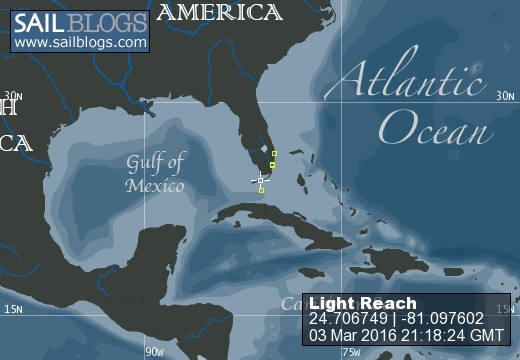
We made it across the Florida Straits and through the Gulf Stream. Another first for us! We were so fortunate that our crossing weather was benign and we had no equipment failures, bad weather or human break downs! The day started out with about 10 knots of wind out of the Southeast and the seas were a bit rolly. It wasn't an awful ride but you needed to hold on when you went down below. The period of the swells was about 10 seconds which made them uncomfortable but bearable. I was amazed at the amount of traffic out there, mostly pleasure boats. We did see a few freighters but had no close encounters. We entered the Gulf Stream about 10:00 AM which picked our speed up as we had hoped. We saw 7 knots briefly at one point but averaged 6.5 a nice boost. We rode the stream until well past sunset at 7:30. In addition as we got closer to the banks the wind and seas died to nearly nothing. The ocean was pretty flat and it was hot during the day. After the sunset it was just clammy and dark. There was a sliver of moon behind us as we approached the banks. We made splendid time arriving at South Riding Rock at 9:30 PM. A 15 hour trip not bad at all. We were in radio contact with Sue and Roger throughout the day and they led the way past the rock.
We had a couple moments of confusion as we passed onto the banks when the current got a hold of us and had us heading right toward the rock itself. It was pretty black out there and we both got a bit disoriented as we straightened out where we were. Thank goodness for the chart plotter. Once onto the banks we set the route for Russell Beacon and settled in for a long dark night ghosting through the waters of the Great Bahama Bank. The night was very hazy with some clouds which made visibility quite low. We lost sight of Sue and Roger who were paralleling our path at a rate a bit faster than we were traveling. We could see them on the AIS intermittently as it was spitting out error messages about priority signals. (We have discovered that it does this when there is too much traffic for it to handle) We were not alone out there .... even if we really couldn't see any other boats. We took turns on watch but neither of us slept much or well.
We made it to Russel Beacon, which only exits in the mind of chatographers, at 6:00 AM. There is a rock there to be avoided which we gave a wide margin. About an hour or so before we got there Sue radioed to say they were going to alter course to go South of the beacon. We opted to stay the course I had charted, being dark and all I didn't want to go wandering around in unfamiliar territory. Not that we had been where we were, (like that makes sense) but I had at least an idea of the water depths when I created the route.
It was with great relief we watched the sunrise as we headed toward the North Channel light. Daylight revealed the amount of traffic out there! Holy cow how we all missed each other in the dark is a miracle. The person who told us you don't want to approach North Channel Light in the dark knew there stuff. The channel is not tremendously wide and there was lots of traffic. As we were approaching the light we saw Dancin Down wind off to our starboard side heading in the same direction. We were happy to see them but puzzled about the timing as we thought they were quite far ahead of us.
We passed the light (a stick in the water) and made our way into the Northwest Providence channel at 8:45AM. Luck was with us in that the seas were just a moderate chop and while we had some wind it was light and variable. We set our course for Morgans Bluff. Sue and Roger did pull out their jib and spent some time noodling along with what wind we had. Light Reach remained under motor as the Captain went below to get some shut eye. At about 1:30 PM we made the turn to approach the anchorage looking anxiously for the marks which were clearly evident on the charts. Humph another cartographers dream. As we made our approach a voice (Ishtar) on the VHF radio announced that customs was in the harbor and it was a good time to hustle in and get cleared. Oooh we had not expected to be able to clear in until Monday. What luck but we still had to get in and get anchored before Scott could clear us in. I asked Ishtar if there were marks and the reply was no but follow the route on your charts as if there were, which we did arriving in the harbor to find another 11 boats already in the anchorage. And most of them we recognized from Marathon. Small sailing world! It took us some time to get the anchor set and a couple of attempts. The holding here is not the best in grass over sand but we got the job done. As we were anchoring Sue and Roger arrived and anchored in front of us. Roger offered to take Scott in with him to clear as he can get his dingy and motor down much faster than us. A big thank you to Roger. I tidied up the boat and Scott headed in to clear.
Clearing in went smoothly, that colored shirt and clean shorts must have made Scott look trust worthy and of sound mind. He returned to the boat about an hour later with our cruising papers in hand. Yee haw we made it!!
It took a bit of time to get the dingy off the front deck and settled in with the motor. We were both running on empty by this point so declined Sue and Rogers offer of sundowners on Dancin Down Wind. We had a light supper and a toast to making it across the stream and banks. Can you believe it WE MADE IT TO THE BAHAMAS!!!!!
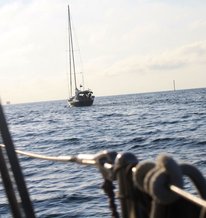
The picture is of Dancin Down Wind in front of us as we pass the Northwest Channel Light. That stick you see is the light.
We had a couple moments of confusion as we passed onto the banks when the current got a hold of us and had us heading right toward the rock itself. It was pretty black out there and we both got a bit disoriented as we straightened out where we were. Thank goodness for the chart plotter. Once onto the banks we set the route for Russell Beacon and settled in for a long dark night ghosting through the waters of the Great Bahama Bank. The night was very hazy with some clouds which made visibility quite low. We lost sight of Sue and Roger who were paralleling our path at a rate a bit faster than we were traveling. We could see them on the AIS intermittently as it was spitting out error messages about priority signals. (We have discovered that it does this when there is too much traffic for it to handle) We were not alone out there .... even if we really couldn't see any other boats. We took turns on watch but neither of us slept much or well.
We made it to Russel Beacon, which only exits in the mind of chatographers, at 6:00 AM. There is a rock there to be avoided which we gave a wide margin. About an hour or so before we got there Sue radioed to say they were going to alter course to go South of the beacon. We opted to stay the course I had charted, being dark and all I didn't want to go wandering around in unfamiliar territory. Not that we had been where we were, (like that makes sense) but I had at least an idea of the water depths when I created the route.
It was with great relief we watched the sunrise as we headed toward the North Channel light. Daylight revealed the amount of traffic out there! Holy cow how we all missed each other in the dark is a miracle. The person who told us you don't want to approach North Channel Light in the dark knew there stuff. The channel is not tremendously wide and there was lots of traffic. As we were approaching the light we saw Dancin Down wind off to our starboard side heading in the same direction. We were happy to see them but puzzled about the timing as we thought they were quite far ahead of us.
We passed the light (a stick in the water) and made our way into the Northwest Providence channel at 8:45AM. Luck was with us in that the seas were just a moderate chop and while we had some wind it was light and variable. We set our course for Morgans Bluff. Sue and Roger did pull out their jib and spent some time noodling along with what wind we had. Light Reach remained under motor as the Captain went below to get some shut eye. At about 1:30 PM we made the turn to approach the anchorage looking anxiously for the marks which were clearly evident on the charts. Humph another cartographers dream. As we made our approach a voice (Ishtar) on the VHF radio announced that customs was in the harbor and it was a good time to hustle in and get cleared. Oooh we had not expected to be able to clear in until Monday. What luck but we still had to get in and get anchored before Scott could clear us in. I asked Ishtar if there were marks and the reply was no but follow the route on your charts as if there were, which we did arriving in the harbor to find another 11 boats already in the anchorage. And most of them we recognized from Marathon. Small sailing world! It took us some time to get the anchor set and a couple of attempts. The holding here is not the best in grass over sand but we got the job done. As we were anchoring Sue and Roger arrived and anchored in front of us. Roger offered to take Scott in with him to clear as he can get his dingy and motor down much faster than us. A big thank you to Roger. I tidied up the boat and Scott headed in to clear.
Clearing in went smoothly, that colored shirt and clean shorts must have made Scott look trust worthy and of sound mind. He returned to the boat about an hour later with our cruising papers in hand. Yee haw we made it!!
It took a bit of time to get the dingy off the front deck and settled in with the motor. We were both running on empty by this point so declined Sue and Rogers offer of sundowners on Dancin Down Wind. We had a light supper and a toast to making it across the stream and banks. Can you believe it WE MADE IT TO THE BAHAMAS!!!!!
The picture is of Dancin Down Wind in front of us as we pass the Northwest Channel Light. That stick you see is the light.
Comments
| Vessel Name: | Light Reach |
| Vessel Make/Model: | Pacific Seacraft 37 |
| Hailing Port: | Annapolis Md |
| Crew: | Scott and Sally and missing our CSO India the wonder Schnauzer she sails on in our hearts |
| About: | |
| Extra: | "I must go down to the sea again, to the lonely sea and the sky; and all I ask is a tall ship and a star to steer her by." John Masefield |
Light Reach's Photos - Main
 |
August 2015 visit to Keuka Lake (New York Finger Lakes)
1 Photo
Created 2 September 2015
|
S/V Light Reach
Who: Scott and Sally and missing our CSO India the wonder Schnauzer she sails on in our hearts
Port: Annapolis Md