Mystic Star Points South
Mystic Star Sailing Adventures in Florida and the Bahamas
26 April 2023
21 April 2023 | Core Creek
26 March 2023 | Hopetown, Abacos
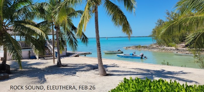
26 February 2023 | Rock Sound, Eleuthera
25 January 2023 | Big Majors Spot
03 January 2023 | Fort Pierce
10 November 2022 | Jekyll Island, Georgia
29 April 2021 | Rock Hall, MD
12 April 2021 | Savannah, GA
22 March 2021 | Fort Pierce, Florida
15 December 2020 | Fort Pierce, Florida
13 November 2020 | Myrtle Beach SC
02 May 2019
19 April 2019 | Georgetown, South Carolina
29 March 2019 | Hopetown
07 March 2019 | Black Point Return
11 February 2019 | Little Bay - Great Guana Cay
22 January 2019 | Rock Sound, Eleuthera
12 January 2019 | Spanish Wells
30 December 2018 | Key Biscayne, Outside Noname Harbor
Home Port Rock Hall
26 April 2023
Bill Zimmerman
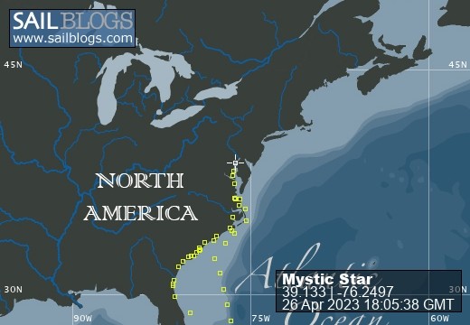
We had a good sail down the Neuse river (NC) under genoa alone with 15k behind us, increasing to 20k as we turned into the Bay River and a short section of canal connecting to the Pamlico River via Goose Creek (Sat, Apr 22). Once out in the Pamlico, the wind had increased to 25-30k from the south, with higher gusts, so we sped along up the Pungo River and into the tributary at the town of Belhaven, NC, where we arrived at 1330. The breakwater at the mouth of this creek cut down some of the chop, but it was not enough where we anchored just off the town docks to be able to launch the dinghy and go ashore without making a very soggy trip of it. So we were not able to get into town that day which was a trend in the weather that was to continue through the rest of April. The next day (Apr 23, Sun) we continued motoring up the Pungo River to the long straight Pungo-Alligator canal (where we saw a swimming Alligator for once) and then to the Alligator River. From there we continued across the Albemarle Sound with a light to moderate wind astern so we could sail, then motor sail our way to the North River and on up another 15 nm to the docks at Coinjock. We enjoyed dinner there at the marina and were on our way the next morning (Mon, Apr 24) with timing as to catch the swing bridges and locks without too much waiting. The Great Bridge Lock had a mechanical issue that only allowed opening every two hours, so we timed it to be there ready to transit at the 1400 opening and it all worked out fine. The only downside to departure that day was strong headwinds in the Currituck Sound where the deep channel is quite narrow and one has to be careful to stay close to the recommended route (Bob423 line) to avoid grounding in bad conditions. The spray from the bow hitting the chop covered the boat with brine, and we were thankful to at least have a decent dodger to hide behind, if not a full cockpit enclosure which would have been welcome on this day. And fortunately we had no barge crossings to deal with that morning. Once we were to the bridges and the lock the weather turned fair and the rest was easy. The last opening bridge, the Gilmerton Lift bridge had it's last opening at 1530, and we made it through at 1515 and on out the Elizabeth River between Portsmouth and Norfolk VA. This stretch is quite a busy section of commercial ports, barge and ship traffic, major naval shipyard and base and container ports. Once through that we turned into Willoughby Bay just off Hampton Roads to anchor for the night. My first selection of a spot to anchor near the north shore was not the best. We observed a bunch of barges anchored in the NE corner of the bay and later a tug came close by to work the barges as we were getting ready for dinner. I called the captain to see if we were going to be a problem for him and he said yes, it would be better for us to move, so we did to a point further south and more in the middle of the bay. In many times in the past, this had been an out of the way good spot to anchor, but a major elevated highway reconstruction project was underway near there, making it into a busy work zone. It is still a decent spot to take off from for a trip up the Chesapeake.
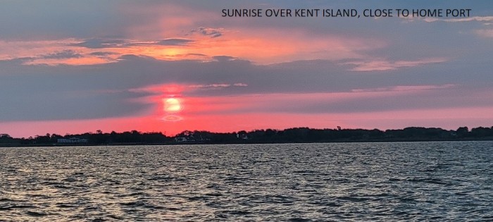
On Tuesday (Apr 25) we had planned to head out early, but winds had picked up from the northeast, directly on our path, so we paused for a few hours to let that simmer down a bit. Our original plan was to take three moderate days of 50 nm or so each to get up the bay, stopping at a few of our favorite spots. However, as we made our way motor-sailing into headwinds our friends on Star Reacher convinced us to continue on overnight all the way home, since the forecast for subsequent days was not looking good. By later in the afternoon, the wind had died and we motored in near calm across the Potomac and through the upper bay at night. In the early hours we had enough wind to gently sail past Annapolis and on to Rock Hall for arrival at about 0800 (Apr 26). It was not a bad way to end the expedition! Some data from the trip: 3103 nm traveled, 499 hours underway, 6.2 kt ave speed, since Oct 24 departure.
On Tuesday (Apr 25) we had planned to head out early, but winds had picked up from the northeast, directly on our path, so we paused for a few hours to let that simmer down a bit. Our original plan was to take three moderate days of 50 nm or so each to get up the bay, stopping at a few of our favorite spots. However, as we made our way motor-sailing into headwinds our friends on Star Reacher convinced us to continue on overnight all the way home, since the forecast for subsequent days was not looking good. By later in the afternoon, the wind had died and we motored in near calm across the Potomac and through the upper bay at night. In the early hours we had enough wind to gently sail past Annapolis and on to Rock Hall for arrival at about 0800 (Apr 26). It was not a bad way to end the expedition! Some data from the trip: 3103 nm traveled, 499 hours underway, 6.2 kt ave speed, since Oct 24 departure.
Green Turtle Cay to North Carolina
21 April 2023 | Core Creek
Bill Zimmerman | Sunny, light breeze
On Monday, March 27, we headed out of Hopetown Harbour for the last time this season and on westward in the Sea of Abaco. Our destination was the anchorage inside near what was left of the Treasure Cay Marina. We had visited this place last in 2019 but later that year hurricane Dorian hit the facility pretty hard. We anchored in the area where the mooring field used to be, which was reportedly clear of debris, but the large area of marina docks and slips was gone and the marina buildings were stripped away leaving only the pool and the tiled beach bar amidst some remaining debris. The large resort on the long beach side was intact and functional with many parts being rebuilt and expanded. It's a beautiful mile plus long beach with white sand and protected waters which we walked and swam off of. Later we had a good pizza dinner at the beach side resort/club restaurant.
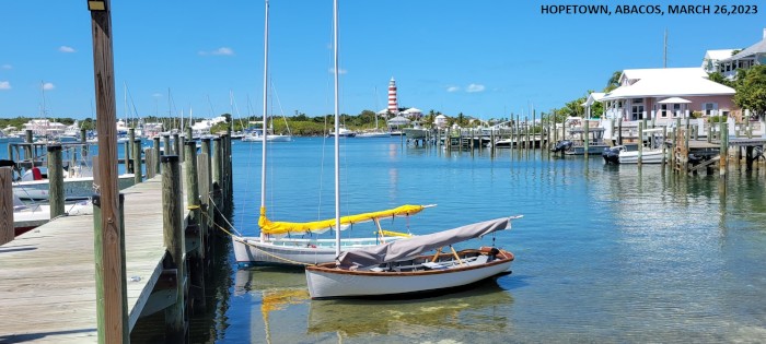
The next day (Tues, Mar 28) we headed out and around "The Whale" to arrive at Green Turtle Cay and Black Sound near the main town of New Plymouth. No moorings were available but we were able to get dock space for not much more cost. We stayed there for four nights and had a good time walking to town, as well as renting a golf cart for a day to tour the cay. We also enjoyed get-togethers with cruisers at "Pineapples" pool bar and on the marina grounds. And breakfast in the "liquor store" was fun. As in many places in the Abacos, recovery from Dorian was still underway. But things like the old Post Office were still in ruins, with no mail service or delivery for the locals. We learned that to send or receive mail, one has to take the ferry to Marsh Harbour, and there seems to be no plan to reinstate service that ended 3.5 years ago, something we take for granted back home. Next we headed north on Green Turtle to White Sound where we wanted to spend another day and to avoid being tide bound in Black Sound with its shallow entrance channel. We had a final lunch at the waterside "Tranquil Turtle" with Fancy Free before going our separate ways back to Florida over the next days. Saturday (Apr 2) we headed out for a short trip (13 nm) further NW to uninhabited Powell Cay where we anchored in an uncharacteristic west wind with the shore to our lee. Despite the chop, we got in our dinghies for a trip ashore, a choppy beach landing and across the narrow wooded isthmus to the long secluded beach on the far side. Turtles came to see us for our last contact with land in the Bahamas. That night the wind went calm with a clear sky and near full moon. On Monday (Apr 3) we headed out and motored 41 nm westward on the banks to Great Sale Cay, another uninhabited cay, that many folks use as a jumping off point for the trip back home towards points in Florida or northward. We got some rest in the afternoon then hoisted anchor at midnight with the full moon and sailed westward towards Mantanilla shoal and the edge of the Little Bahama Bank, about 50 nm away. It was a nice sail up until daybreak when the wind veered too far astern and eased so that we motored on, still heading WNW so as to catch the Gulf Stream, which we gradually entered by noon. By 1400 we were speeding north under engine alone with the current pushing us along so that our speed over the ground was over 10 knots for the next 12 hours. By 2200 we started angling our way out of the stream and towards our destination of St. Augustine, FL. We never did get any sailable wind since the early morning sail, and as we approached the coast we encountered a mile or so of very dense fog. That made finding the entrance marks challenging and required electronic navigation and radar only to get through the inlet. Once inside, the fog was above water level so that we made our way normally to the city marina and south through the
"Bridge of Lions" drawbridge to a mooring near the marina and city center by 1045. (The trip was 264 nm, over 34.7 h, 7.6 k ave speed). We spent three nights here at the city moorings once again enjoying the sights, walking about the town and the fort, and many the restaurants to choose from. It did seem like it was particularly busy with tourists and a waiter at one place told us that the crowds had been unexpectedly large that week, maybe in part due to the great weather. By Saturday (Apr 8) the weather was expected to deteriorate quite a bit, so we moved to Comachee Cove Marina just north of the city for a few days to catch up on laundry, maintenance, etc. Tuesday (Apr 11) we finally left St Augustine and headed north in the ICW. We had some close calls with high water at a few fixed bridges due to all the rain, just getting through with the flexible masthead VHF antenna bending back, but no problems otherwise. The weather had not improved a whole lot and the day was drizzly and cool by the time we made it to anchor at Cumberland Island by 1830. Offshore weather was not conducive for sailing north outside, so we continued on through the winding swamps of Georgia for the next few days. The few shallow spots were not an issue due to the time of our passage well away from low tide. We did encounter the small coastal cruise ship "American Star" as we transited one of the narrowest channels at the Little Mud River, but with the AIS we could call them and plan to pause in a wide spot so as to avoid any drama. Wednesday we stopped at anchorage in the Crescent River and Thursday we made it to anchor in the Skidaway River near Thunderbolt GA after getting pounded by a brief T-storm. On Friday (Apr 14) we headed in the ICW about 10 nm to the Savannah River then down the river with the ebbing tide at a good clip to be back on the ocean. Forecast was for light air, but we had a decent SE breeze all afternoon so we sailed on a reach towards Winyah Bay and Georgetown SC. In mid-afternoon we were sailing along at full speed when the clew of the genoa jib tore out. Apparently the threads on the tabs had failed due to UV damage, though they were not that old. We were able to roll up the sail and secure it with wraps of two spinnaker halyards, so we proceeded with the solent jib, and double reefed main at decent speed and were set for safe sailing overnight. As the evening approached, we could see on radar that there were rain storm cells approaching, but they seemed to all pass north of us without a drop. We thought we were home free, but as darkness fell, the wind died and veered astern, so we motored with the double reefed main alone through the night. However, at midnight a bunch of cells popped up all around us with flashes of lightning at an increasing rate. Within thirty minutes we were in the midst of a light show with cloud to cloud lightning flashing every second for a good two and a half hours. Luckily there was virtually no cloud to ground lightning and only a few actual of thunderclaps and not much rain or wind. By 0200 the cells had mostly blew on by us and we proceeded in relative calm. Quite a start to my eighth decade which also started at midnight! By 0700 we made the mouth of Winyah Bay, but had to fight the ebb tide for a few hours to get up to Georgetown. We took a spot on the face dock at Hazzard Marina there for a couple of nights as our plan was to visit there. The little historic downtown and surrounding side streets have wonderful huge oak trees whose branches are lined with the resurrection ferns that spring to life after rain showers. There's no Spanish moss on the trees here as there are in Charleston and further south, but the stubby thick ferns covering the old limbs are unique. We enjoyed several good meals at favorite restaurants here, and met friends Mark and Chris who were in town sightseeing after a cruise on one of those American Cruise lines inshore cruises, which was fun.
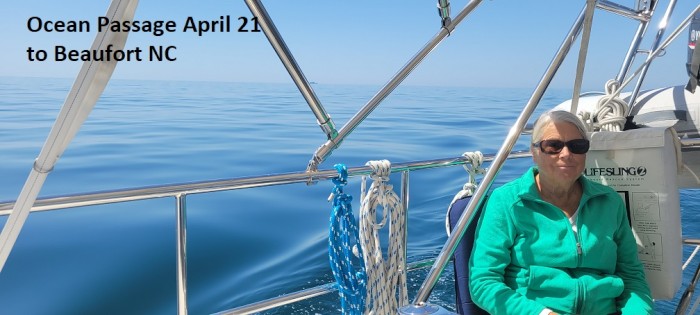
So Monday (Apr 17) we pulled off the dock and headed up the Waccamaw River for a long motoring run to the SC-NC line at Little River (57 nm). The first one third of that trip winds through the beautiful flooded cypress forests that is a unique sight. Later on it proceeds through straight manmade cuts inshore from Myrtle Beach past untold numbers of homes lining the waterway that vary from pretty nice to over the top extravagant. At the Little River state line, there is a great anchorage just inside the river inlet north of Bird island, a popular stopover and all natural anchoring spot. That set us up for a relatively short day's run of 27 nm inshore to Southport NC where we planned to stop for a couple of nights. Scott & Kathy had owned a place on nearby Oak Island and were very familiar with the area. We enjoyed touring with them and going to favorite restaurants, walking the miles long Atlantic beach. In addition I found a sail loft that agreed to repair the sail the next day, but it was 30 miles away in Wilmington NC. So we rented a car for two days from a convenient place near to the marina and used it for touring and to deliver the sail to the loft. We also took the time to walk around the old downtown of historic Wilmington which we had not done before. Thursday early (Apr 20) we returned to the sail loft and promptly picked up the sail, stopped for breakfast in Kure Beach, then took the car ferry back to Southport and were off the dock by 1040. From there we headed up the Cape Fear River to Snow's Cut and ICW past Carolina Beach and on to anchor near the inlet at Wrightsville Beach by 1440, a 25 nm trip. At anchor we hoisted the repaired genoa jib and were ready for some sailing. As I write, we are underway to Beaufort inlet (about 68 nm) after departing Masonboro inlet early and the favorable weather will allow us to continue inshore through to Cedar Creek off Addams Creek to a quiet protected anchorage for the night. The ocean is a flat glassy calm with clear blue skies, not conducive to sailing once again, but a quick comfortable trip nonetheless.
The next day (Tues, Mar 28) we headed out and around "The Whale" to arrive at Green Turtle Cay and Black Sound near the main town of New Plymouth. No moorings were available but we were able to get dock space for not much more cost. We stayed there for four nights and had a good time walking to town, as well as renting a golf cart for a day to tour the cay. We also enjoyed get-togethers with cruisers at "Pineapples" pool bar and on the marina grounds. And breakfast in the "liquor store" was fun. As in many places in the Abacos, recovery from Dorian was still underway. But things like the old Post Office were still in ruins, with no mail service or delivery for the locals. We learned that to send or receive mail, one has to take the ferry to Marsh Harbour, and there seems to be no plan to reinstate service that ended 3.5 years ago, something we take for granted back home. Next we headed north on Green Turtle to White Sound where we wanted to spend another day and to avoid being tide bound in Black Sound with its shallow entrance channel. We had a final lunch at the waterside "Tranquil Turtle" with Fancy Free before going our separate ways back to Florida over the next days. Saturday (Apr 2) we headed out for a short trip (13 nm) further NW to uninhabited Powell Cay where we anchored in an uncharacteristic west wind with the shore to our lee. Despite the chop, we got in our dinghies for a trip ashore, a choppy beach landing and across the narrow wooded isthmus to the long secluded beach on the far side. Turtles came to see us for our last contact with land in the Bahamas. That night the wind went calm with a clear sky and near full moon. On Monday (Apr 3) we headed out and motored 41 nm westward on the banks to Great Sale Cay, another uninhabited cay, that many folks use as a jumping off point for the trip back home towards points in Florida or northward. We got some rest in the afternoon then hoisted anchor at midnight with the full moon and sailed westward towards Mantanilla shoal and the edge of the Little Bahama Bank, about 50 nm away. It was a nice sail up until daybreak when the wind veered too far astern and eased so that we motored on, still heading WNW so as to catch the Gulf Stream, which we gradually entered by noon. By 1400 we were speeding north under engine alone with the current pushing us along so that our speed over the ground was over 10 knots for the next 12 hours. By 2200 we started angling our way out of the stream and towards our destination of St. Augustine, FL. We never did get any sailable wind since the early morning sail, and as we approached the coast we encountered a mile or so of very dense fog. That made finding the entrance marks challenging and required electronic navigation and radar only to get through the inlet. Once inside, the fog was above water level so that we made our way normally to the city marina and south through the
"Bridge of Lions" drawbridge to a mooring near the marina and city center by 1045. (The trip was 264 nm, over 34.7 h, 7.6 k ave speed). We spent three nights here at the city moorings once again enjoying the sights, walking about the town and the fort, and many the restaurants to choose from. It did seem like it was particularly busy with tourists and a waiter at one place told us that the crowds had been unexpectedly large that week, maybe in part due to the great weather. By Saturday (Apr 8) the weather was expected to deteriorate quite a bit, so we moved to Comachee Cove Marina just north of the city for a few days to catch up on laundry, maintenance, etc. Tuesday (Apr 11) we finally left St Augustine and headed north in the ICW. We had some close calls with high water at a few fixed bridges due to all the rain, just getting through with the flexible masthead VHF antenna bending back, but no problems otherwise. The weather had not improved a whole lot and the day was drizzly and cool by the time we made it to anchor at Cumberland Island by 1830. Offshore weather was not conducive for sailing north outside, so we continued on through the winding swamps of Georgia for the next few days. The few shallow spots were not an issue due to the time of our passage well away from low tide. We did encounter the small coastal cruise ship "American Star" as we transited one of the narrowest channels at the Little Mud River, but with the AIS we could call them and plan to pause in a wide spot so as to avoid any drama. Wednesday we stopped at anchorage in the Crescent River and Thursday we made it to anchor in the Skidaway River near Thunderbolt GA after getting pounded by a brief T-storm. On Friday (Apr 14) we headed in the ICW about 10 nm to the Savannah River then down the river with the ebbing tide at a good clip to be back on the ocean. Forecast was for light air, but we had a decent SE breeze all afternoon so we sailed on a reach towards Winyah Bay and Georgetown SC. In mid-afternoon we were sailing along at full speed when the clew of the genoa jib tore out. Apparently the threads on the tabs had failed due to UV damage, though they were not that old. We were able to roll up the sail and secure it with wraps of two spinnaker halyards, so we proceeded with the solent jib, and double reefed main at decent speed and were set for safe sailing overnight. As the evening approached, we could see on radar that there were rain storm cells approaching, but they seemed to all pass north of us without a drop. We thought we were home free, but as darkness fell, the wind died and veered astern, so we motored with the double reefed main alone through the night. However, at midnight a bunch of cells popped up all around us with flashes of lightning at an increasing rate. Within thirty minutes we were in the midst of a light show with cloud to cloud lightning flashing every second for a good two and a half hours. Luckily there was virtually no cloud to ground lightning and only a few actual of thunderclaps and not much rain or wind. By 0200 the cells had mostly blew on by us and we proceeded in relative calm. Quite a start to my eighth decade which also started at midnight! By 0700 we made the mouth of Winyah Bay, but had to fight the ebb tide for a few hours to get up to Georgetown. We took a spot on the face dock at Hazzard Marina there for a couple of nights as our plan was to visit there. The little historic downtown and surrounding side streets have wonderful huge oak trees whose branches are lined with the resurrection ferns that spring to life after rain showers. There's no Spanish moss on the trees here as there are in Charleston and further south, but the stubby thick ferns covering the old limbs are unique. We enjoyed several good meals at favorite restaurants here, and met friends Mark and Chris who were in town sightseeing after a cruise on one of those American Cruise lines inshore cruises, which was fun.
So Monday (Apr 17) we pulled off the dock and headed up the Waccamaw River for a long motoring run to the SC-NC line at Little River (57 nm). The first one third of that trip winds through the beautiful flooded cypress forests that is a unique sight. Later on it proceeds through straight manmade cuts inshore from Myrtle Beach past untold numbers of homes lining the waterway that vary from pretty nice to over the top extravagant. At the Little River state line, there is a great anchorage just inside the river inlet north of Bird island, a popular stopover and all natural anchoring spot. That set us up for a relatively short day's run of 27 nm inshore to Southport NC where we planned to stop for a couple of nights. Scott & Kathy had owned a place on nearby Oak Island and were very familiar with the area. We enjoyed touring with them and going to favorite restaurants, walking the miles long Atlantic beach. In addition I found a sail loft that agreed to repair the sail the next day, but it was 30 miles away in Wilmington NC. So we rented a car for two days from a convenient place near to the marina and used it for touring and to deliver the sail to the loft. We also took the time to walk around the old downtown of historic Wilmington which we had not done before. Thursday early (Apr 20) we returned to the sail loft and promptly picked up the sail, stopped for breakfast in Kure Beach, then took the car ferry back to Southport and were off the dock by 1040. From there we headed up the Cape Fear River to Snow's Cut and ICW past Carolina Beach and on to anchor near the inlet at Wrightsville Beach by 1440, a 25 nm trip. At anchor we hoisted the repaired genoa jib and were ready for some sailing. As I write, we are underway to Beaufort inlet (about 68 nm) after departing Masonboro inlet early and the favorable weather will allow us to continue inshore through to Cedar Creek off Addams Creek to a quiet protected anchorage for the night. The ocean is a flat glassy calm with clear blue skies, not conducive to sailing once again, but a quick comfortable trip nonetheless.
Spanish Wells and Hopetown
26 March 2023 | Hopetown, Abacos
Bill Zimmerman | Sunny warm
We stayed for three days at Rock Sound, Eleuthera, visiting the "Cathedral Caves" that we've enjoyed on previous trips, when it used to be called "Spider Cave" and "Ocean Hole" in the middle of town. On Monday (Feb 27) we rented a car from the Stationery Supply Store there (who knew you could rent a car at a stationery supply?--there's no clue to that effect on the outside of the building!) and drove north to Governor's Harbour and the Leon Levy Park Preserve, also a favorite spot. This well maintained botanical garden has excellent displays of native plants with descriptions of their many uses as food and medicines by former natives. It also has miles of trails through the dense growth and a lookout tower above it all. It was particularly dry this time and so much of the epiphytes (bromeliads and orchids) that are a highlight in the jungle trails were mostly dormant, unfortunately. Later we made a short venture into the cave north of Hatchet Bay, but did not do the full one-way exploration as we had done in a previous year. We drove as far as the scenic "Glass Window" a bridge over a rugged rocky link between the Atlantic and the banks to the west side of Eleuthera.
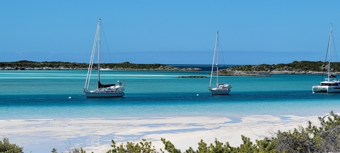
On Tuesday (Feb 28) we decided to move on due to weather (wind direction) considerations. We sailed up the west coast of Eleuthera and checked out Alabaster Bay, where we had hoped to anchor, but the wind was too southerly for decent protection there. As a result we proceeded up the coast another ten miles to Hatchet Bay, a very protected harbor from all directions that is entered through a very narrow cut in in the cliff walls. We stayed there for two days, doing walks around the Alice Town settlement, and taking it easy at anchor. Thursday we headed west towards a passage between islands from the banks to the deeper Northeast Providence Channel known as Current Cut. The trip was timed it so as to transit at slack water (low tide slack) since the current through there can reportedly reach six to eight knots at maximum. Once through there with no issues, we sailed gently to the north and into Spanish Wells and a spot at the Yacht Haven Marina there by mid-afternoon. We spent the weekend there and enjoyed visiting the beaches, driving around in a golf cart to Russell Island, grocery shopping and going to several good restaurants. A personalized tour of the small history museum there from a long-time resident was very informative. Spending a few hours walking the tidal flats north of the island at low tide was fun too.
By Monday (Mar 6) the weather forecast was looking good for a trip north in open water to the Abacos, so we staged for this by heading west to a bight at the west end of Royal Island to be ready the next day. With the help of the full moon, we were up early and off by 04:50 to round Egg Island and north towards the Little Harbour cut into the Sea of Abaco, about 50 nm distant. At first we motored then motor sailed with a light southwest wind which built during the day and veered more westerly so that we could sail at an OK speed, hampered by a current against us most of the way. Afternoon some drizzle started that picked up pace into a heavy rain squall but we were able to continue on course. By the time we reached the cut between the reefs at Little Harbour, the rain had stopped and we entered easily and on into the "Bight of Old Robinson" where we anchored in a protected spot south of Bridge Cay to be sheltered from northerly winds that night. We considered visiting Little Harbour itself, but the limited moorings inside were not coming available during the morning high tide needed for entering. And we received word that our friends on Fancy Free had secured moorings inside Hopetown Harbour on Elbow Cay that morning. Getting a mooring in there is a nearly impossible feat and we were so grateful that they were able to snag moorings for both of us as others left the harbor that day. So we proceeded up the Sea of Abaco 20 nm to Elbow Cay and beat the falling tide to be able to enter the cozy harbor a few hours before low and pick up our reserved mooring. That was on Wedneday, March 8, and we've enjoyed being here for most of the rest of the month. During that time we've enjoyed the small town, walking the narrow paths between the old cottages, many of which have been repaired since the devastation of Dorian in 2019. A number of buildings are still in ruins, the one grocery store near the docks is still out of commission and one famous old hotel has only foundation ruins left. Also many beach walks and dinghy trips to beaches on the sound side, including "Tahiti Beach" with its "Thirsty Cuda" floating bar were fun. We also left the harbor with a 'reserved' float on our mooring to visit Marsh Harbour, the main town in Great Abaco, where much more devastation had been experienced from Dorian. Some of the stores and buildings have been rebuilt including three of the larger marinas, but there are many vacant lots with remnants of foundations left. During our stay, I also took the opportunity to tackle a few needed boat repairs. Two of the mainsail's batten pockets had torn out and had to be patched with heavy sail cloth that I found in a canvas shop nearby in the harbor. The propeller shaft needed to be re-aligned since settling of the new motor mounts that were replaced last spring had recently caused some new vibrations under load. And the head pump quit at one point and needed servicing. Always something...it's a boat after all.
By the time of this writing it's getting a bit warm here with diminished wind and temperatures in the eighties, not quite as pleasant as the high seventies we've been experiencing. That's telling us it's about time to move on to points north and to start to look for a weather window to make the passage across to northern Florida and beyond. We plan to move northwestward to Green Turtle Cay and spend a week or so in that cozy harbor, then be off towards the US by the second week of April.
Exumas, Long Island, Conception & Cat Islands, Eleuthera
26 February 2023 | Rock Sound, Eleuthera
Bill Zimmerman | Sunny Warm
Tuesday, Jan 24 we headed back north in a quick morning sail to Pipe Cay, about 6 nm from our spot at Big Majors. We dingied to shore to land near the big concrete wharf there from the days of the Decca station that was constructed for the base of a navigation system in use after WWII. There seemed to be some new construction here since our last visit four years ago, but has since halted, purposes unknown. After a long walk on the exposed tidal flats at low tide east of the cay, we returned to our boats rocking in a building southeasterly breeze. Wednesday, Jan 25 we proceeded northwards back into the Exuma Land & Sea Park through the Rocky Dundas Bore and into the anchorage at Cambridge Cay. We found that the park moorings were all occupied there and the extra spaces around the perimeter were also full with anchored boats, so we went on further to anchor in a bight on the east side of Bell Island that offered some protection from the SE wind and chop. From there we dinghied north past OBriens Cay to snorkel a the "Aquarium" spot, so named for the abundance of colorful reef fish and corals. We also hiked the trails at the north end of Cambridge Cay to some dramatic cliffs and "Oven Rock" near shore there, as well as a trail through the "stumpy" palms to an isolated beach at the south of the cay. Bell Island itself is interesting in that it is a private island within the Exuma Park and as a result, no landing is allowed. It turns out that the ownership of the island can be traced to the Aga Kahn, the Islamic spiritual leader and descendant of Muhammad.
Friday, Jan 27, we sailed out into Exuma Sound for a short trip to Staniel Cay to pick up a new handheld radio that I had shipped in via the very convenient airport freight service there, then went on south to Blackpoint Settlement to stay through the weekend. We took advantage of the waterfront laundromat there and a few lunches out as well as long walks ashore. On Monday (Jan 30) we sailed back north for five miles to Bitter Guana Cay to anchor near the high white cliffs there off of a beautiful beach. This is one of only a few cays that has a native population of pink iguanas, who approach beach visitors looking for snacks. We hiked up the rocks to a broad high ground with great views of the nearby cays and waters. Tuesday we sailed south on the banks along the long narrow Great Guana Cay to anchor west of Little Farmers Cay. We had lunch at Ty's sunset grill and walked the small island, spoke with Terry, owner of the famous "Ocean Cabin" restaurant in the center of town. Anchored nearby us were friends we met from "Breeze On" with whom we had a chance to catch up with since we last saw them in 2017. The next day (Feb 1) we moved a few miles back north to "Oven Rock" at the southern end of Great Guana Cay where we landed at a beach and took the trail to the pool cave that we've visited on our last two trips. I enjoyed snorkeling in the cool dark waters once again.
Thursday, Feb 2, we headed out Galliat cut into Exuma Sound for a 12 nm sail to Adderly cut and Lee Stocking Island, an upwind sail in 11-14 kts. The next day we enjoyed a long walk in a big loop around the northern end of the island that is now a ghost town of sorts. Not long ago it was the site of a marine research facility that was rather suddenly abandoned (2012?) but recently has caretakers keeping things up a bit. Some downed trees and wreckage that we saw back in 2016 had been cleared. (See previous blog entries). We also did the scenic hike up to Perry's Peak, the highest point in the Exuma chain for great views, from a quiet beach on the west side south of our anchorage. On Saturday (Feb 4) we headed back out Adderly Cut into Exuma Sound and SE for the 30 nm run to Elizabeth Harbour and Georgetown. We found a spot amidst the many boats here near Monument Beach, in the lee of Stocking Island, where we were to stay for over a week. The boat count in the harbor at that point was something like 340 boats, more than have been seen since 2017(?). For the next days we enjoyed going ashore to Stocking Island for hikes across to the windswept beaches on the Sound side, up Monument Hill, and going to "Chat & Chill" and "Da Sand Bar". By Feb 12, Superbowl Sunday, we moved across the harbor south of Goat Cay to avoid some westerly winds as well as to be near the sports bar "Splash" where we watched our Eagles fall to the Chiefs. At least it was a pretty good game for both the offenses. The next day we heading into Kid Cove and the Exuma Yacht Club for refueling then moved back across the harbor to "Sand Dollar Beach" to the south. From there, we were set to head out south and east early on Tuesday (Feb 14) towards Thomson Bay, Long Island. We had a good day to make progress to the east which is normally a slog to windward, sailing for about half of the 38 nm trip. The shore-side amenities there in the settlement of "Salt Pond" are spread out along the one north-south running highway so we went in by dinghy to take advantage of a little resupply before the high winds kicked in the next day. For Thurs (Feb 16) we arranged to rent a car for the day to sight see Long Island. We first headed south to find the Hamilton Caves and got a great personal tour of the caverns from Leonard Cartwright a descendent of the loyalists who settled there around 1800. This is also near the famous "Dean's Blue Hole" which we visited where free divers descend to hundreds of feet from a platform on the surface. We stopped at the marina in Clarencetown for lunch which was very good and then drove north to the northern terminus of the road on the island. There up on a hill is a monument to Columbus and the Lucayans overlooking the Cape named after his flagship, Cape Santa Maria. Since our last visit in 2017 the road to the monument and the grounds have been dramatically improved. On the return south we visited the ruins of Adderley's Plantation established in 1790, which was kind of overgrown and had been mostly destroyed by a hurricane in 1927. On Friday (Feb 17) we had a great broad reach sail north to Calabash Bay, near Cape Santa Maria, in 18-22 kts of wind. We anchored there off the beach resort and walked the beach, and had drinks at the bar/restaurant. The weather looked good for a visit to the small uninhabited Conception Island, which is a protected national park site about 15 nm NE of the northern tip of Long Island. So Saturday (Feb 18) we headed out of Calabash Bay and off in that direction. By noon we were anchored in the NW corner of the island off the long curving beach there, in the amazing crystal blue waters. Due to the tide state, late that afternoon we headed south around the points of land in the dinghies for several miles to the salina in the mangroves to see turtles and a few rays darting underneath us. We found the creek's waters to be not nearly as clear as in past years, probably due to the time of high tides on this day which were inconveniently around sunrise and sunset. The next day was another fair weather day to enjoy this pristine island. I also had to make some repairs to our genoa jib that had some tabbing at the tack point coming loose.
Monday, Feb 20, we weighed anchor and headed out to NW toward the southern tip of Cat Island. It turned out to be a downwind run which we made mostly on a starboard tack, then gybed westward for awhile before returning to a northerly direction to round the southwestern cape at Hawks Nest. During our westward gybe, we hooked a decent Mahi Mahi that I landed on the swim platform. But before I could get it off the gaff and remove the hook, it riggled its way back into the sea on its own. So close to fresh fish dinner! Such is the fate of a rank amateur fisherman. In any event we arrived at our anchorage at New Bight, Cat Island by 1600, a 43 nm trip. On Tueday and Wednesday we enjoyed exploring on shore there, with a highlight being our hike up to Mt. Alvernia, the site of a one-man monastery built by Father Jerome in 1947 (see photos). This is on the highest point in the Bahamas at 206 ft and has a great view of the island from ocean to sound side. We landed the dinghy on the north end of the beach to hike up the road to a brand new laundromat there to take care of laundry, which was great with plenty of new machines, all working. The conch salad at Duke's on the beach was also excellent, though the no-see-ems had a feast on us while we patiently waited for the salad prep in the late afternoon. Olive's Bakery had the homemade coconut bread we remembered from our last time here in 2017. We made a move up the coast a few miles to the more cozy Fernandez Bay on Thursday (Feb 23). There is a nice resort there on a beautiful beach and a rocky islet in the middle of the bay that we snorkeled to see a great variety and number of reef fish and corals. We enjoyed meeting people at the Tiki bar and arranged to have dinner that evening in the restaurant there which was very good. On Friday we sailed up the Cat Island coast about 12 nm to check out an area near "Big Bluff" as a possible anchorage and shore exploration, but the shoreline there looked to be inaccessible with no landing and steep rock walls only. So we continued on in a westerly direction from there another 24 nm over to Little San Salvador Island. The island is also known as Half Moon Cay for its beautiful beach forming a long arc to the north and east. Cruise ship lines feature this place as a private-island get-away, and is set up with hundreds of beach lounge chairs, cabanas and bars for the shore-goers. They allow visitors like ourselves to roam the beach only after their guests have left via launch to their anchored mega-ship, which on this day happened by 3 PM. It's a great protected spot to stop for the night to break up the trip from Cat Island to Eleuthera. Early the next morning we headed out west in that direction across the strait known as "The Bridge" between Little San Salvador and Southern Eleuthera. It was a perfect sailing day on a broad reach to the west and northwest to round Cape Eleuthera at the southwestern corner. We motored the final 10 nm back into the wind to the east through some sand bores and on into Rock Sound, a well protected bay on the east side of southern Eleuthera. We plan to pause here for a couple of days, possibly taking a tour by rental car before resuming our travels in a northerly direction.
On to the Bahamas
25 January 2023 | Big Majors Spot
Bill Zimmerman
On Jan 6, Friday, we departed Fort Pierce Marina for points south. We made our way down the Indian River on the AICW past Jensen Beach, Stuart, through Hobe Sound and on to North Palm Beach to anchor in a popular spot at the north end of Lake Worth. The next morning we left before dawn for the long run down the coast on the outside to Miami. We sailed for a while in the east wind then motor-sailed as the wind backed astern of us. By 1530 we were heading into Government cut and south of the busy cruise ship terminal at Dodge Island, then north under several bridges and east to anchor just south of Belle Isle with easy dinghy access to the densely populated Miami Beach. The days run was 74 nm. The next day we did some last provisioning at convenient Publix and Trader Joe's and enjoyed lunch with the Mayhue's family that drove from Fort Lauderdale to see us off. Our weather router was indicating that Tuesday would be a good time to cross the Gulf Stream to the Bahamas, so we got ourselves situated for that on Monday by moving south about 10 nm to Key Biscayne and "No Name" Harbor at its south end. The crossing started by leaving harbor at 11 AM and heading out east in a light north wind under engine. It was still fairly rolly with seas on the beam, so we were glad to be across just after dark at 18:30. Once on the banks we had a light south wind to sail in the moonlight in flat water at a leisurely pace to make our destination in the Berry Islands at 9 AM Wednesday (Jan 11). That was a 130 nm run over 22 hrs. We stayed for two nights at the Chub Cay Marina and Resort, a very nice place with modern solid floating docks and beautiful grounds, though expensive. Clearance into the Bahamas was easily done via online signup and a golf cart ride to the tiny airport there. By Friday (Jan 13) a cold front was expected to come through the islands bringing very strong NW winds so we headed east in the pre-frontal southerly winds to Royal Island, at the northern end of Eleuthera Island. We did this to gain ground to the east so that when the easterly trade winds resumed, we could easily make our way south to the Exumas. Royal Island has a small bay with a narrow entrance to provide protection from waves from most directions. That was appreciated as the winds built up to 25-30 kts overnight Friday and all day Saturday, then gradually decreased to low 20s then teens on Sunday. We headed out for the northern Exumas on Monday with much decreased winds to arrive at Highborne Cay by mid-afternoon. From there we headed south to Shroud Cay at the northern end of the chain of cays making up the Exuma Land and Sea Park. In the park there is a fee for mooring or anchoring overnight and it is a wildlife preserve for the islands and waters out 4 miles east and west. On Tuesday afternoon, during high tide, we made a dinghy expedition through the mangroves to the eastern side of the cay and to the site of "Camp Driftwood" up on a ridge there. The place has an interesting history (see previous blogs). After speaking with some cruisers we had first met years earlier, we learned of a new (for us) route back through the mangroves to the south to exit on the west side near where the boat was moored.
Next we sailed for Warderick Wells and the Exuma Park Headquarters on the beautiful protected horseshoe shaped mooring field in the midst of shallow sand bars and ringed by rocky cays. We stayed there for two nights and one more night at the Emerald Rock mooring field. It's been a repeat of what we've done in previous years, but some of the most enjoyable times and naturally beautiful scenery of our winter trips here. The hiking trails inland are quite rugged over sharp broken rocks sometimes in the midst of poison wood trees (same effect as poison ivy--only trees), but the views from the hilltops and secluded beaches are worth the effort. The snorkeling at the small coral heads west of Emerald Rock was wonderful with an abundance of fish and healthy looking hard corals emerging from the sandy bottom in super clear water.
By Saturday, Jan 21, we were on our way south, out of the park towards Staniel Cay and anchorage at Big Majors Island. We enjoyed lunch at the marina bar and some resupply at stores there, and proximity to cell towers (absent in the park) meant we could catch up on communications and watch a little NFL playoff action. We did the swimming pig beach thing and snorkeled at Thunderball Grotto--the small islet with the caverns you swim into at low tide, along with the rest of the tourists, but still fun. At this point we plan to head north back into the park's southern cays for the week before resuming our southerly cruising down the Exuma chain.
| Vessel Name: | Mystic Star |
| Vessel Make/Model: | Outbound 46 /2008 /Hull #37 |
| Hailing Port: | Rock Hall MD |
| Crew: | Bill & Donna |
| About: | |
| Extra: |
Mystic Star's Photos - Eleuthera
MYSTIC STAR
Who: Bill & Donna
Port: Rock Hall MD