The Grander Scheme: s/v Northern Symphony
Another simple dream...Another crazy notion: To make a sequel to our Grand Scheme by making an extended great loop starting from our home in Nova Scotia. One boat, two so-called adults, one or two children, and one cat.
s/v Northern Symphony
Who: The Wightmans
Port: Lunenburg, NS
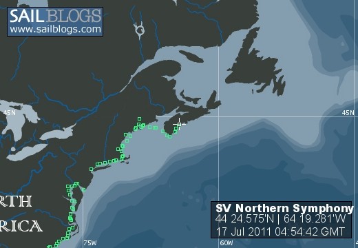
17 July 2011 | Mahone Bay, NS
13 July 2011 | Clarks Harbour, NS
04 July 2011 | Yarmouth, NS
22 June 2011 | Yarmouth, NS
20 June 2011 | Richmond, ME
19 June 2011 | Rockport, MA
16 June 2011 | Gloucester, MA
15 June 2011 | Sandwich, MA
13 June 2011 | Point Judith, RI
12 June 2011 | Mystic, CT
08 June 2011 | Mystic, CT
06 June 2011 | New York, NY
05 June 2011 | New York, NY
01 June 2011 | Baltimore, MD
23 May 2011 | Baltimore, MD
17 May 2011 | Baltimore, MD
16 May 2011 | Selby Beach, MD
15 May 2011 | Crisfield, MD
14 May 2011 | Cape Charles, VA
12 May 2011 | Norfolk, VA
...and the straight and narrow!
10 December 2010 | Cumberland Island, GA
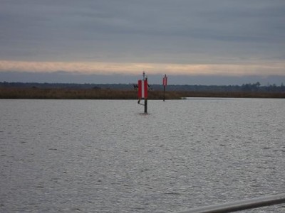
Strange as it may seem, the winding road through the low country is composed of a great many straight sections, which pose a challenge: Often, the channel that is deep enough for larger boats is a rather narrow strip through what looks like a wide open area...picture trying to stay in a fifty-foot wide strip of water through a mile-wide expanse of water...with cross currents...and wind...
The solution to this challenge is remarkably simple: A range, essentially two sticks, like the one in the picture. If you keep the two markers lined up, you are in the channel. If they aren't lined up, you can tell which way to go. In the picture, the channel is to port (left) of where the picture was taken. Today we had a lot of ranges as we wound our way down through the most remote part of Georgia before finally anchoring at the Cumberland Island National Seashore, where we will spend Saturday hiking and exploring and generally taking a break after several long days of driving the boat.
Along the way, we got to motor out almost into the ocean: In crossing the sound between Jekyll and Cumberland Islands, the ICW heads out and around a rather extensive shoal. Although there are sand bars that trip and break the true ocean waves, the route is still exposed and, as we were passing at high tide, the effect of the sand bars was diminished. For half an hour we motored out in three to five foot seas driven by 15-20 knot winds, rounded a buoy, and surfed back into Buttermilk sound. Anne and I thoroughly enjoyed it but, as we observed afterwards, five years ago that foray into the waves might have scared us...now it was just fun.
Comments
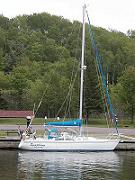
| Vessel Name: | Northern Symphony |
| Vessel Make/Model: | 1990 Catalina 36, Tall Rig |
| Hailing Port: | Lunenburg, NS |
| Crew: | The Wightmans |
| About: | Colin (skipper), Anne, Evelyn, Leslie, and Scourge-of-the-Sea, our boat kitty. |
Northern Symphony's Photos - Main
 |
|
A collection of photos showing various parts and stages of our refit during the spring of 2010
No Photos
Created 6 June 2010
|
s/v Northern Symphony
Who: The Wightmans
Port: Lunenburg, NS