
Tai Mo Shan
05 December 2022 | Tasman Sea
06 January 2021 | Moreton Bay, Australia
23 October 2020 | Brisbane, Australia
15 October 2020 | Gladstone, Australia
12 October 2020 | Mackay, Australia
07 October 2020 | Mackay, Australia
03 October 2020 | Townsville Australia
25 September 2020 | Magnetic Island, Australia
20 September 2020 | Hinchinbrook Island, Australia
12 September 2020 | Great Palm Island, Australia
12 September 2020 | Horseshoe Bay, Magnetic Island, Australia
06 September 2020 | Townsville, Australia
18 August 2020 | Townsville, Australia
12 August 2020 | Hook Reef, Australia
10 August 2020 | Hook Island, Australia
10 August 2020 | South Molle Island, Australia
06 August 2020 | Airlie Beach, Australia
06 August 2020 | Cid Harbour, Whitsunday Group, Australia
29 July 2020 | Shaw Island, Australia
29 July 2020 | Goldsmith Island, Australia
Passage to Fiji, or New Caledonia - May 19
27 May 2019 | Noumea
Paul Dickinson
Gentlemen cruise downwind
Our plan for the 2019 cruising season was to depart Brisbane and head to Fiji, spend a couple of months in Fiji and then move onto to New Caledonia and spend some months there. We had friends in Fiji and would like to revisit them, and we wanted to cruise the Yasawa group of islands. We had visited New Caledonia for a few weeks last year, found that was no where near enough time to explore a very good cruising ground, and so we were keen to return for a longer period.
Of course, sailing to Fiji, and even New Caledonia meant heading east. The trade winds blow through the region and are consistently in the southerly to easterly quadrant. In short we would be sailing against the wind and current. That is why most sail from the east to the west. Using a good weather window with reduced easterly winds, or ideally southerly winds, would therefore be important.
The forecast before the weekend of 11/12 May seemed to be favourable with low pressure systems in the Tasman, followed by a weak high pressure. Brisbane was due to have a weather system with cloudy weather and easterly winds blow through early in the weekend followed by southerly winds, and a wind shift to the east later. It seemed we had a suitable window. We therefore booked customs for early Monday 13 May.
The weekend in Brisbane was fairly sunny with a few clouds. Monday dawned cloudy. Still customs were on time at an early 0800. 4 officers arrived at the boat. 2 went below and 2 remained in the cockpit. A few questions and forms filled out, including those allowing us tax back on Helen’s new ring, and our forthcoming fuel purchase. As ever, the formalities were easy and the officers polite. 20 minutes later they left, we had last showers, said goodbye to the office staff, dropped off access cards, and cast off.
The first trip was short one, just across the fairway to the Moreton Bay Trailer Boat Club fuel dock where we filled up our diesel tanks and petrol can, as well as topped up our LPG bottles. The attendant was helpful and happily told us that it was mid tide, and we had 2 metres of water at the fuel dock; the evidence was in the muddy water we kicked up from our prop wash as we left; we draw 1.9 meters!
Soon we were in Moreton Bay, where a brisk South Easterly wind started up from what was a very still morning. This was accompanied by bands of squally train. Fortunately we were well protected by our hardtop and clears, and stayed dry as we made good time up Moreton Bay. By the afternoon the wind was more variable, lighter with more easterly and certainly not what was forecast. Still, we pushed on and our 1800 position check saw us just clearing the entrance to Moreton Bay near Caloundra. Here we turned east and pushed into a squally, gusty south east wind.
That night became a game of dodging several large ships converging on the entrance to Moreton Bay as they either headed to, or departed from, the bust port of Brisbane. Added to the mix was a horde of fishing boats. These were readily distinguishable as from the front they only had faint navigation lights, but had very bright lights illuminating their stern and, presumabl,y the water just behind. We have AIS (Automatic Identification System) on board. This transmits a VHF signal giving our name, position, heading speed etc that can be picked up by other AIS equipped craft. We can also receive AIS signals from other vessels. The large ships all have AIS, so ‘seeing’ them is relatively easy and assured. However, only about 2/3 of the fishing boats appeared to have AIS, so keeping a visual lookout was essential. The sky was cloudy so, despite there being a bright moon, the sea surface was dark. In addition, the variable gusty south easterly wind meant keeping our course was challenging. The mix got so difficult that near midnight we started our motor to ensure we had the manoeuvrability required to miss the traffic! Still we had to call one ship ‘Bombay Express’ to let them know where we were; they altered course to avoid us as they acknowledged they had us on AIS!
The morning of Tuesday 14 May saw improved visibility and less traffic. We could sail again in the rather unpleasant gusty shifting winds. We estimate the wind to have been south east (plus or minus 15 degrees) and between 10 and 35 gusting 40 knots! The sea state matched the wind with steep waves of about 1 metres of so. The sailing was tricky with several changes of sail size/ reefs (furling and unfurling the Yankee), but we could make progress and just about hold our desired course. We were hard on the wind, heeled over at an angle of 15 to 20 degrees, with some roll. Unfortunately this meant our nearly full diesel fuel tanks vented into the cockpit. We therefore had a few dribbles of diesel and the associated fumes to contend with. We managed to download the synoptic charts for the pacific using weather fax. These showed that the forecast had changed, markedly changed. There were no low pressure systems around, instead a continuous series of high pressure systems stretched from Australia across the Tasman Sea and past New Zealand. These would act to increase the trade winds, the phenomenon we were seeing. And given, this weather pattern we would have increased trade winds for weeks! Still, we were making progress and so we pushed on.
Around about midnight, turning into Wednesday 15 May, we carried out another reef of the Yankee as the wind increased. Unfortunately our port side signal line broke. Normally this would not be a problem, but this time the loose string caught around the Yankee sheet and fouled it as it passed through a pulley. We could not reef! A tense ten minutes followed as Paul moved forward (tethered to our new jack stays of course) and cut the string free. Fortunately we could then reef, with no damage done.
Wednesday continued with us sailing hard on the wind in the gusty squally conditions and mounting sea. We could not hold our course and were being gradually pushed further north. The only solution was to tack and sail in a southerly direction. With reefed sails and high seas we found our tacking angle was a comparatively large 120 degrees. This meant that after the tack we were barely headed to our destination, instead crossing our desired path. Two tacks during the day saw us almost back on our planned path, albeit costing us some progress. Whilst we had sailed a total of 118 nautical miles (nm) over the 24 hours from Tuesday 1800, we had only made 99 nm towards our destination.
Thursday saw much the same with steep high seas, and gusty squally winds. Unfortunately the wind had shifted more to the East and so we were forced to put in more tacks to remain close to our planned course. The tacks were particularly demoralising as our 103 nm sailed translated to only 43 nm to our destination. Clearly the trip was going to be a very long one, taking much longer than we had planned.
Friday was again a similar day. The wind had sifted marginally to the south east allowing a better sailing angle, although we were still having to tack, creating a ‘saw tooth’ track, to keep close to course. Our 1800 hours position calculation showed we had sailed some 114 nm, and 69 nm to destination.
On Friday our freezer started malfunctioning. We kept getting air locks in the cooling system. The freezer is cooled by salt water, which comes through a hull fitting, goes through the strainer, freezer cooling coils and then exhausts to the sea through another hull fitting. Closer examination showed that the nut holding the top of the strainer had corroded away and was close to failing completely. This would have allowed salt water to flow freely into the hull; not a desirable occurrence as we aim to keep the sea out of the boat. The solution was to bypass the strainer completely. We still kept getting airlocks, presumably due the extended periods of relatively high angles of heel together with the rough seas sucking air under the boat. Anyone who thinks syphoning raw sea water through sucking is bad, try sucking through hot raw sea water! Still, anything to stop our large store of frozen food spoiling. Hot salt water – ugh!
Late Friday night it was clear to us that the constant pushing hard into the wind and wave was not doing us or the boat any good. We were finding it difficult to get sufficient sleep and so fatigue was becoming a factor. The boat was handling the waves really well most of the time, but was still catching large waves side on with a resultant loud bang and shudder. We were 5 days out, about half way to New Caledonia, and some 3 weeks from Fiji. We reluctantly decided that Fiji would push boat and crew too far. Instead we would head directly to Noumea, New Caledonia. Aside from being a shorter distance, the course was some 7 degrees further north; a slight but useful angle off the wind. So New Caledonia it would be.
First we had to get past Capel Bank. This is a seamount that rises from the ocean floor (some 2000 metres deep) to a charted depth of only 50 metres. Indeed one part of the seamount is charted at only 10 metres deep. Drawing 1.9 metres, we could sail clean over the mount; however, the ocean currents would be affected by such a giant subsea mountain and, so fearing an even more confused and higher sea we decided to sail around the bank, keeping to the 200 metre depth contour. Our original course would have meant tacking to remain south of the bank. Our revised course allowed us to ease slightly to the north. The change was marked as Tai Mo Shan easily made 7 knots, taking the seas at a better angle. Of course, this could not last, and after a few hours we had to adjust back to sailing tight on the wind, having ‘lost’ some 20 miles to the north.
That evening saw a flurry of email activity as we informed New Caledonian, Fijian and Australian customs as well as the Copra Shed marina at Savusavu of our change plans.
Saturday 18 May saw much of the same. Tai Mo Shan pushing hard on the strong gusty south easterly wind in high seas. We could almost hold our course to Noumea, typically ‘losing’ some 5 degrees to north. We decided against tacking, and instead concentrated on sailing as high (i.e. close to the wind) as we could. We had some entertainment in the form of a pair of Booby Birds. These deep sea voyagers saw us and came to have a closer look, flying very close to us for over half an hour. At one point it looked like one was about to land on the solar panels on our rear ‘bridge’. Fortunately it saw the whirring blades of our wind generator just above the bridge, and veered away at the last minute so avoiding a messy end.
Sunday was much the same, pushing hard into strong winds and high seas. The days seemed to be establishing a weather pattern. The dawn would break with almost clear skies, lighter winds and gentler seas. Indeed, with the promise of a better day weather wise. However, by midday the clouds had thickened to say 4/8 cover, the winds had generally increased in both strength and gustiness, and the seas increased in height. By dusk we were in the same pattern of strong gusty winds, fuelled by the clouds, with a rough fairly confused sea.
Monday 20 May saw a slight favourable wind shift, but again, pushing hard into strong winds and high seas. By now we were used to the extreme motion, with water often spraying over the hardtop. It was a case of holding on, and making the best progress we could.
Tuesday 21 May, much the same. However, at 1000 we heard a ‘securite’ broadcast from the French Maritime Rescue Centre at Noumea on the VHF radio. We were still some way off, but it was reassuring to be in VHF range. By midday it was clear that we would reach the coast of New Caledonia some 70 miles north of Noumea at about midnight. We would then have to tack to sail south for another day before being able to tack back onto course. New Caledonia is a long thin island running approximately south east. The southerly tack would therefore take us away from the coast, an unbearable thought! The alternative was to start the motor and force our way through the waves and wind the 80 or so miles direct to the reef entry and on to Noumea. This would cost us in terms of fuel, but at least we would be going direct to destination. So, we started the motor. Normally full power will push us along at some 7 knots on flat water with no wind. The conditions off New Caledonia were such that whilst we could occasionally reach 4.5 knots, we averaged 3.4 knots. At times the multiple waves were sufficient to completely stop the boat! Still we smashed through and the wave action eased marginally as we approached the coast.
At 1810 it was dark and we spotted lights off the port side. These were quite bright and spread out. They could be from a large ship, but we had no AIS ‘targets’. We had spotted the lights of a small town on New Caledonia, land ahoy!
As dawn broke on Wednesday 22 May we could make out the blue shapes of the hills of the mainland of New Caledonia. The seas had eased as we got closer to the coast and so we were making a better speed; 5 knots or so.
1100 saw us line up for the reef entry at Passe de Doumbea. This is a wide passage, some 0.6nm across and well marked with a post on the reef to the north, a red buoy in the channel and a ‘cardinal post’ on the other side of the channel. No problem. But the current was impressive. We estimate some 2 knots against us. This was enough to really whip up the surface of the sea, and create large smooth upwellings. Still we motored on and were soon past the reef and turbulent water. Once inside the fringing reef the wind remained strong at 20 knots plus, but the water was almost smooth. We motor sailed past small sandy islets and well marked reefs. It was beautiful with clear water changing colour with the depths from blue to aqua green, white sand beaches, green vegetation, blue sky and occasional white clouds. A real relief.
We anchored in the anchoring area just off Noumea in Baie de l’Orphelinat at 1320 Queensland time (1420 New Caledonia time). Time for a shower, tidy up, celebratory bottle of fizzy Moscato, and then sleep. Tomorrow we would contact the marina and clear in.
And the statistics – 979 nm sailed in 9 days 3 hours. The direct route is about 788 nm.
It was a very tough passage. Now we know why gentlemen cruise downwind!
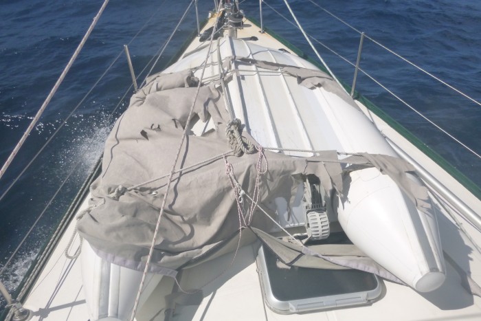
Picture – the dinghy cover did not survive the trip!
Our plan for the 2019 cruising season was to depart Brisbane and head to Fiji, spend a couple of months in Fiji and then move onto to New Caledonia and spend some months there. We had friends in Fiji and would like to revisit them, and we wanted to cruise the Yasawa group of islands. We had visited New Caledonia for a few weeks last year, found that was no where near enough time to explore a very good cruising ground, and so we were keen to return for a longer period.
Of course, sailing to Fiji, and even New Caledonia meant heading east. The trade winds blow through the region and are consistently in the southerly to easterly quadrant. In short we would be sailing against the wind and current. That is why most sail from the east to the west. Using a good weather window with reduced easterly winds, or ideally southerly winds, would therefore be important.
The forecast before the weekend of 11/12 May seemed to be favourable with low pressure systems in the Tasman, followed by a weak high pressure. Brisbane was due to have a weather system with cloudy weather and easterly winds blow through early in the weekend followed by southerly winds, and a wind shift to the east later. It seemed we had a suitable window. We therefore booked customs for early Monday 13 May.
The weekend in Brisbane was fairly sunny with a few clouds. Monday dawned cloudy. Still customs were on time at an early 0800. 4 officers arrived at the boat. 2 went below and 2 remained in the cockpit. A few questions and forms filled out, including those allowing us tax back on Helen’s new ring, and our forthcoming fuel purchase. As ever, the formalities were easy and the officers polite. 20 minutes later they left, we had last showers, said goodbye to the office staff, dropped off access cards, and cast off.
The first trip was short one, just across the fairway to the Moreton Bay Trailer Boat Club fuel dock where we filled up our diesel tanks and petrol can, as well as topped up our LPG bottles. The attendant was helpful and happily told us that it was mid tide, and we had 2 metres of water at the fuel dock; the evidence was in the muddy water we kicked up from our prop wash as we left; we draw 1.9 meters!
Soon we were in Moreton Bay, where a brisk South Easterly wind started up from what was a very still morning. This was accompanied by bands of squally train. Fortunately we were well protected by our hardtop and clears, and stayed dry as we made good time up Moreton Bay. By the afternoon the wind was more variable, lighter with more easterly and certainly not what was forecast. Still, we pushed on and our 1800 position check saw us just clearing the entrance to Moreton Bay near Caloundra. Here we turned east and pushed into a squally, gusty south east wind.
That night became a game of dodging several large ships converging on the entrance to Moreton Bay as they either headed to, or departed from, the bust port of Brisbane. Added to the mix was a horde of fishing boats. These were readily distinguishable as from the front they only had faint navigation lights, but had very bright lights illuminating their stern and, presumabl,y the water just behind. We have AIS (Automatic Identification System) on board. This transmits a VHF signal giving our name, position, heading speed etc that can be picked up by other AIS equipped craft. We can also receive AIS signals from other vessels. The large ships all have AIS, so ‘seeing’ them is relatively easy and assured. However, only about 2/3 of the fishing boats appeared to have AIS, so keeping a visual lookout was essential. The sky was cloudy so, despite there being a bright moon, the sea surface was dark. In addition, the variable gusty south easterly wind meant keeping our course was challenging. The mix got so difficult that near midnight we started our motor to ensure we had the manoeuvrability required to miss the traffic! Still we had to call one ship ‘Bombay Express’ to let them know where we were; they altered course to avoid us as they acknowledged they had us on AIS!
The morning of Tuesday 14 May saw improved visibility and less traffic. We could sail again in the rather unpleasant gusty shifting winds. We estimate the wind to have been south east (plus or minus 15 degrees) and between 10 and 35 gusting 40 knots! The sea state matched the wind with steep waves of about 1 metres of so. The sailing was tricky with several changes of sail size/ reefs (furling and unfurling the Yankee), but we could make progress and just about hold our desired course. We were hard on the wind, heeled over at an angle of 15 to 20 degrees, with some roll. Unfortunately this meant our nearly full diesel fuel tanks vented into the cockpit. We therefore had a few dribbles of diesel and the associated fumes to contend with. We managed to download the synoptic charts for the pacific using weather fax. These showed that the forecast had changed, markedly changed. There were no low pressure systems around, instead a continuous series of high pressure systems stretched from Australia across the Tasman Sea and past New Zealand. These would act to increase the trade winds, the phenomenon we were seeing. And given, this weather pattern we would have increased trade winds for weeks! Still, we were making progress and so we pushed on.
Around about midnight, turning into Wednesday 15 May, we carried out another reef of the Yankee as the wind increased. Unfortunately our port side signal line broke. Normally this would not be a problem, but this time the loose string caught around the Yankee sheet and fouled it as it passed through a pulley. We could not reef! A tense ten minutes followed as Paul moved forward (tethered to our new jack stays of course) and cut the string free. Fortunately we could then reef, with no damage done.
Wednesday continued with us sailing hard on the wind in the gusty squally conditions and mounting sea. We could not hold our course and were being gradually pushed further north. The only solution was to tack and sail in a southerly direction. With reefed sails and high seas we found our tacking angle was a comparatively large 120 degrees. This meant that after the tack we were barely headed to our destination, instead crossing our desired path. Two tacks during the day saw us almost back on our planned path, albeit costing us some progress. Whilst we had sailed a total of 118 nautical miles (nm) over the 24 hours from Tuesday 1800, we had only made 99 nm towards our destination.
Thursday saw much the same with steep high seas, and gusty squally winds. Unfortunately the wind had shifted more to the East and so we were forced to put in more tacks to remain close to our planned course. The tacks were particularly demoralising as our 103 nm sailed translated to only 43 nm to our destination. Clearly the trip was going to be a very long one, taking much longer than we had planned.
Friday was again a similar day. The wind had sifted marginally to the south east allowing a better sailing angle, although we were still having to tack, creating a ‘saw tooth’ track, to keep close to course. Our 1800 hours position calculation showed we had sailed some 114 nm, and 69 nm to destination.
On Friday our freezer started malfunctioning. We kept getting air locks in the cooling system. The freezer is cooled by salt water, which comes through a hull fitting, goes through the strainer, freezer cooling coils and then exhausts to the sea through another hull fitting. Closer examination showed that the nut holding the top of the strainer had corroded away and was close to failing completely. This would have allowed salt water to flow freely into the hull; not a desirable occurrence as we aim to keep the sea out of the boat. The solution was to bypass the strainer completely. We still kept getting airlocks, presumably due the extended periods of relatively high angles of heel together with the rough seas sucking air under the boat. Anyone who thinks syphoning raw sea water through sucking is bad, try sucking through hot raw sea water! Still, anything to stop our large store of frozen food spoiling. Hot salt water – ugh!
Late Friday night it was clear to us that the constant pushing hard into the wind and wave was not doing us or the boat any good. We were finding it difficult to get sufficient sleep and so fatigue was becoming a factor. The boat was handling the waves really well most of the time, but was still catching large waves side on with a resultant loud bang and shudder. We were 5 days out, about half way to New Caledonia, and some 3 weeks from Fiji. We reluctantly decided that Fiji would push boat and crew too far. Instead we would head directly to Noumea, New Caledonia. Aside from being a shorter distance, the course was some 7 degrees further north; a slight but useful angle off the wind. So New Caledonia it would be.
First we had to get past Capel Bank. This is a seamount that rises from the ocean floor (some 2000 metres deep) to a charted depth of only 50 metres. Indeed one part of the seamount is charted at only 10 metres deep. Drawing 1.9 metres, we could sail clean over the mount; however, the ocean currents would be affected by such a giant subsea mountain and, so fearing an even more confused and higher sea we decided to sail around the bank, keeping to the 200 metre depth contour. Our original course would have meant tacking to remain south of the bank. Our revised course allowed us to ease slightly to the north. The change was marked as Tai Mo Shan easily made 7 knots, taking the seas at a better angle. Of course, this could not last, and after a few hours we had to adjust back to sailing tight on the wind, having ‘lost’ some 20 miles to the north.
That evening saw a flurry of email activity as we informed New Caledonian, Fijian and Australian customs as well as the Copra Shed marina at Savusavu of our change plans.
Saturday 18 May saw much of the same. Tai Mo Shan pushing hard on the strong gusty south easterly wind in high seas. We could almost hold our course to Noumea, typically ‘losing’ some 5 degrees to north. We decided against tacking, and instead concentrated on sailing as high (i.e. close to the wind) as we could. We had some entertainment in the form of a pair of Booby Birds. These deep sea voyagers saw us and came to have a closer look, flying very close to us for over half an hour. At one point it looked like one was about to land on the solar panels on our rear ‘bridge’. Fortunately it saw the whirring blades of our wind generator just above the bridge, and veered away at the last minute so avoiding a messy end.
Sunday was much the same, pushing hard into strong winds and high seas. The days seemed to be establishing a weather pattern. The dawn would break with almost clear skies, lighter winds and gentler seas. Indeed, with the promise of a better day weather wise. However, by midday the clouds had thickened to say 4/8 cover, the winds had generally increased in both strength and gustiness, and the seas increased in height. By dusk we were in the same pattern of strong gusty winds, fuelled by the clouds, with a rough fairly confused sea.
Monday 20 May saw a slight favourable wind shift, but again, pushing hard into strong winds and high seas. By now we were used to the extreme motion, with water often spraying over the hardtop. It was a case of holding on, and making the best progress we could.
Tuesday 21 May, much the same. However, at 1000 we heard a ‘securite’ broadcast from the French Maritime Rescue Centre at Noumea on the VHF radio. We were still some way off, but it was reassuring to be in VHF range. By midday it was clear that we would reach the coast of New Caledonia some 70 miles north of Noumea at about midnight. We would then have to tack to sail south for another day before being able to tack back onto course. New Caledonia is a long thin island running approximately south east. The southerly tack would therefore take us away from the coast, an unbearable thought! The alternative was to start the motor and force our way through the waves and wind the 80 or so miles direct to the reef entry and on to Noumea. This would cost us in terms of fuel, but at least we would be going direct to destination. So, we started the motor. Normally full power will push us along at some 7 knots on flat water with no wind. The conditions off New Caledonia were such that whilst we could occasionally reach 4.5 knots, we averaged 3.4 knots. At times the multiple waves were sufficient to completely stop the boat! Still we smashed through and the wave action eased marginally as we approached the coast.
At 1810 it was dark and we spotted lights off the port side. These were quite bright and spread out. They could be from a large ship, but we had no AIS ‘targets’. We had spotted the lights of a small town on New Caledonia, land ahoy!
As dawn broke on Wednesday 22 May we could make out the blue shapes of the hills of the mainland of New Caledonia. The seas had eased as we got closer to the coast and so we were making a better speed; 5 knots or so.
1100 saw us line up for the reef entry at Passe de Doumbea. This is a wide passage, some 0.6nm across and well marked with a post on the reef to the north, a red buoy in the channel and a ‘cardinal post’ on the other side of the channel. No problem. But the current was impressive. We estimate some 2 knots against us. This was enough to really whip up the surface of the sea, and create large smooth upwellings. Still we motored on and were soon past the reef and turbulent water. Once inside the fringing reef the wind remained strong at 20 knots plus, but the water was almost smooth. We motor sailed past small sandy islets and well marked reefs. It was beautiful with clear water changing colour with the depths from blue to aqua green, white sand beaches, green vegetation, blue sky and occasional white clouds. A real relief.
We anchored in the anchoring area just off Noumea in Baie de l’Orphelinat at 1320 Queensland time (1420 New Caledonia time). Time for a shower, tidy up, celebratory bottle of fizzy Moscato, and then sleep. Tomorrow we would contact the marina and clear in.
And the statistics – 979 nm sailed in 9 days 3 hours. The direct route is about 788 nm.
It was a very tough passage. Now we know why gentlemen cruise downwind!
Picture – the dinghy cover did not survive the trip!
Comments
| Vessel Name: | Tai Mo Shan |
| Vessel Make/Model: | North Cape 43 (Ed Brewer) |
| Hailing Port: | Auckland, NZ |
| Crew: | Paul and Helen Dickinson |
| About: | |
| Extra: | Tai Mo Shan was built in Hong Kong in 1980 by Emsworth Ltd of Athang Hau. Her name translates to 'Big Hat Mountain' which overlooks the boat yard. We prefer 'Tai Mo Shan'; something is lost in translation. Tai Mo Shan has a proud tradition of cruising the Pacific, and we intend to continue that. |
Gallery not available
Who: Paul and Helen Dickinson
Port: Auckland, NZ