
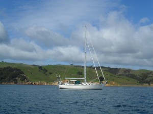
Tai Mo Shan
05 December 2022 | Tasman Sea
06 January 2021 | Moreton Bay, Australia
23 October 2020 | Brisbane, Australia
15 October 2020 | Gladstone, Australia
12 October 2020 | Mackay, Australia
07 October 2020 | Mackay, Australia
03 October 2020 | Townsville Australia
25 September 2020 | Magnetic Island, Australia
20 September 2020 | Hinchinbrook Island, Australia
12 September 2020 | Great Palm Island, Australia
12 September 2020 | Horseshoe Bay, Magnetic Island, Australia
06 September 2020 | Townsville, Australia
18 August 2020 | Townsville, Australia
12 August 2020 | Hook Reef, Australia
10 August 2020 | Hook Island, Australia
10 August 2020 | South Molle Island, Australia
06 August 2020 | Airlie Beach, Australia
06 August 2020 | Cid Harbour, Whitsunday Group, Australia
29 July 2020 | Shaw Island, Australia
29 July 2020 | Goldsmith Island, Australia
Ile Des Pins - June 19
19 June 2019
Paul Dickinson
The Ile Des Pins was yet another old French penal colony used to move criminals and political deportees away from the honest folk of France. Like Prony, it had been active from about 1850 to 1910. We had also heard about the Ile Des Pins as a stop on the cruise ship itinerary. In fact, Leo, Helen’s brother, had been on a cruise which included Ile Des Pins as a stop. We therefore expected to see a significant amount of infrastructure with a ferry terminal, shops, cafes and all the paraphernalia of a major tourist destination. We were wrong.
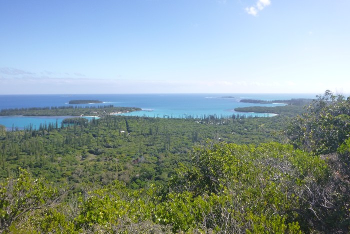
We anchored in the Baie De Kuto. This is a right by the island’s main wharf, where the ferries and cruise ships tie up. In fact, a proportion of the bay is charted as a no-go zone to allow large vessels to turn. The anchorage is very sheltered from all but strong Westerly winds, with good holding in a sand bottom. The water is fairly clear. On calm days we could see the bottom, some 7m below us. It was sand with occasional black patches which could have been flat rocks or sea grass. We saw several turtles in the bay, some very close to, indeed, even under, Tai Mo Shan, and so assumed the dark patches were sea grass. The bay is fringed by a white sand beach, which curves around almost all the bay. Behind the beach is a strip of coastal trees and grass, nicely maintained to provide an excellent large picnic area. The centre of the bay has a hotel complex, with the restaurant, bar and small shop in a well-designed low impact structure right on the beach. There is also another small, closed up, structure, which presumably was a beach café. One end of the bay has the peninsula of Kuto. This has the remains of the colonial fort, the wharf, a slipway, a smaller floating wharf great for dinghy landing, and a large refuse bin (for public use, and really useful!). Behind this is the Gendarmerie (visible by the large French flag and radio masts) and the OPT communications site (visible by larger masts and satellite dishes). However, these man-made structures are all but hidden but lush greenery of large bushes and the ubiquitous tall pine/cicada trees. Further back the island (which is about 11 by 7 miles) is dominated by a low range of hills, topped by the 282m high Pic Nga. These hills are rocky with sparse vegetation, the red rock contrasting well with the green and brown growth. All in all, this is a truly beautiful anchorage.
The island has a population of about 2000 people. Kuto, on the peninsula, has well, not a lot. In addition to the government buildings there are some half a dozen houses, including a small ‘boutique’ selling a few hand painted tee shirts and similar tourist goods. Kaa, in the middle of the bay, has the hotel complex (mostly across the coast road with a couple of dozen huts and 2 blocks for accommodation and a pool), a school complex, and a couple of houses. The next village along, Ouro, about 1km away had the shop, a dozen or so houses and a straight road. The shop is variously called the Boulangerie, Alimentation and Convenience Store. It is small, but sells a restricted range of food and goods. As one would expect the prices are somewhat above Noumea prices. Nevertheless, it is useful for limited supply and an easy walk from the beach.
The main village is Vao, some 6km from the beach. Our cruising guide advised that the locals hold a market there on Wednesdays and Saturdays at which they sell their local produce. We really needed fresh vegetables and so, following the advice in the guide, Paul set off early Wednesday morning. It is an easy walk, just follow the coast road. The road is sealed and two lanes wide. The traffic is light and courteous. Every vehicle gave Paul a wide berth as they passed him on the side of the road, earning a wave from Paul and giving a wave or lift of fingers in return.
Vao is a sizeable village with probably a hundred or so houses. Walking in Paul passed a maintenance depot, school and the Marie (town council building). However, the building that stands out is the church. This is clearly catholic (from the icons), large, white and is located at the head of the long straight main street. It dominates the village. The market was said to be in the square in front of the church. No market there. Paul asked a couple of village women and they replied by pointing and saying ‘La’. Paul duly walked along a bit and just off the main road was a small building with a bank, a market building being built, a war memorial, flat area and in the corner, the market. Well, for market read a long open tent with 4 tables. One was occupied by locals drinking tea, the other three by stalls with village women behind and a total of perhaps 5 small bags of vegetables and fruit between them. Paul approached and looked at the produce. A bag of Kumara type vegetables looked promising. The price of 200 francs seemed to be on the bag. However, with some handling from the locals this changed to 700! Hmm. Ah well, to support the local economy, the bag was purchased; but only the one bag. Paul continued his stroll up the main street. A sports field, few more houses, turn off to Bai St Vincent, and … an Epicure. Closer inspection showed this to be a general store, the second on the island, and almost as big as the one at Ouro. Still, they had had a delivery of produce from Noumea and a large Pumpkin and some carrots ended up in the bag. Paul’s excursion ended with a walk down the road to Baie St Vincent. The road ended in a flat open area with an icon of the saint and a joint memorial to the first European discoverers and the war dead from the First World War. The bay itself is extensive and charted as very shallow. To be honest, the bay is charted as a big grey area! However, the Google Earth images show it as very shallow. This was confirmed by looking out, the water was a very light blue, a sure sign of shallow water over a clear sand bottom, and certainly not navigable by a yacht.
During our wanderings we had noticed a sign indicating a path up Pic Nga. Given how the hill overlooked the whole island, it had to be climbed; by Paul. And so one morning off he went. The path started as a vehicle track through woods, and then became a walking path through the woods, well defined but occasionally washed out. After a while it cleared the woods, and became steeper, and steeper, and steeper as it went straight up the rocky ridge. The day was clear with a bright sun which, as the rocks heated up, made the climb a hot one. Still an hour or so later and Paul was at the summit. This was a small stand of trees, but small paths led to overlooks at the edge of the trees which gave good views across the island and surrounding seas. The island is mostly given over to what looked like pine trees (hence the name!). However, the small airstrip was visible as was the anchorage. The sea view was impressive with deep blue sea interspersed with light blue shallows, brown reefs, and occasional islands of white sand and dark green vegetation. Away from the main peak was a slightly lower peak with less vegetation and a large cross erected. Though lower this gave even better views. Well worth the hot climb.
We also found another path, this time around the peninsula of Kuto. We basically followed a vehicle track off the main road to the coast and then a footpath trail taking us right around the peninsula. This was a pleasant walk including woods and sea shore (well coral shelf and undercut coralline cliffs), ending at the old fort walls.
Back on board Tai Mo Shan we watched the ferries arrive and depart. As one would this transformed the wharf area from a deserted wasteland to a hive of activity of people and vehicles. Apparently the fast passenger ferry (and it was fast – AIS had it at some 28 knots – so Noumea would only be a couple of hours away) visited twice a week and the vehicle ferry once a week. We watched as each docked and was met by the assembled host. Interestingly very many of the passengers were pulling large chilly bins; clearly the regular shopping trip to the Noumea supermarkets!
Back on board we had picked up some ‘pets’. We often get Remora, the fish with big suckers on their heads, under the boat. Here was no exception as up to 10 of them made us their temporary home, happily feeding off our food scraps; nothing gets wasted in the ocean! The hull needed a bit of a clean to get rid of patches of barnacles, worm and algae. Paul therefore donned facemask and snorkel and hopped in to the water as Helen kept watch. An aside, New Caledonia had suffered some shark attacks. Most are, apparently, in cloudy or muddy water; however, just in case … As it was, Paul had a small shoal of little fish around him as he scraped off the foul on the hull. The Remora, reasonable sized fish at 2 to 3 feet long, deigned not to bother with the small stuff and stayed clear of the strange 6 foot long creature!
As usual we engaged with the locals. Paul’s broken French usually sufficed although Helen communicated extremely well with English and hand signals. Always everyone was polite and pleasant, and the conversations often led to bursts of laughter amidst the smiles. One group of young men talked to Paul on the last day as he was taking a bag of rubbish ashore. They were from the Loyalty Islands and were on the Ile Des Pins as a sister had just got married. We had heard the beach party the previous night (!). They explained that many of their family were on the ferry about to depart; could they have a ride in the dinghy? Well 4 could! And so Paul plus 4 went off to the wharf and around the dinghy. The ubiquitous mobile phones were out taking photos. Smiles, waves, shouts of joy and laughter from the dinghy were repeated many fold from those on the wharf and ferry. Good fun.
And so after a pleasant week in a beautiful anchorage we departed and headed back to the Baie De Prony. The forecast was for a South Easterly 10 to 15 wind, which would then reduce to almost nothing for several days. Given that we wanted to go downwind we decided to use the wind before it got light. As it was, the wind was light (probably 10 knots or less) for the entire passage back. This led to an uneventful motor sail in clear water. The only point of note (apart from passing beautiful reefs and islands) was the occasional large splash some distance away – humpback whales jumping! And so, on Monday 17 June we arrived in Anse Majic.
Photo, a beautiful anchorage. Kuto bay in the middle, with the peninsula to the left.
Comments
| Vessel Name: | Tai Mo Shan |
| Vessel Make/Model: | North Cape 43 (Ed Brewer) |
| Hailing Port: | Auckland, NZ |
| Crew: | Paul and Helen Dickinson |
| About: | |
| Extra: | Tai Mo Shan was built in Hong Kong in 1980 by Emsworth Ltd of Athang Hau. Her name translates to 'Big Hat Mountain' which overlooks the boat yard. We prefer 'Tai Mo Shan'; something is lost in translation. Tai Mo Shan has a proud tradition of cruising the Pacific, and we intend to continue that. |
Gallery not available
Who: Paul and Helen Dickinson
Port: Auckland, NZ