
Tai Mo Shan
05 December 2022 | Tasman Sea
06 January 2021 | Moreton Bay, Australia
23 October 2020 | Brisbane, Australia
15 October 2020 | Gladstone, Australia
12 October 2020 | Mackay, Australia
07 October 2020 | Mackay, Australia
03 October 2020 | Townsville Australia
25 September 2020 | Magnetic Island, Australia
20 September 2020 | Hinchinbrook Island, Australia
12 September 2020 | Great Palm Island, Australia
12 September 2020 | Horseshoe Bay, Magnetic Island, Australia
06 September 2020 | Townsville, Australia
18 August 2020 | Townsville, Australia
12 August 2020 | Hook Reef, Australia
10 August 2020 | Hook Island, Australia
10 August 2020 | South Molle Island, Australia
06 August 2020 | Airlie Beach, Australia
06 August 2020 | Cid Harbour, Whitsunday Group, Australia
29 July 2020 | Shaw Island, Australia
29 July 2020 | Goldsmith Island, Australia
Port Bourail – July 2019
17 July 2019 | New Caledonia
Paul Dickinson

Our next anchorage was in Port Bourail. This was some 30 nm up the coast. As the lagoon between the coast and the reef ceased being navigable to yachts just north of Ouano we would have to pass through the reef and sail in the open ocean. We would then pass through the reef again at Port Bourail. We wanted to arrive in Port Bourail with plenty of sunlight. However, given the narrow entrance to Ouano lagoon, and the need to pass through the reef was also wanted to leave in good sunlight. Our compromise was to weigh anchor at 0900 on Friday 12th July.
Unfortunately at 0900 the sun is not high enough to give a clear view into the water. We therefore navigated using the beacons, our past track and the depth sounder. And we proceeded out of Ouano lagoon slowly! All went well although at one point approaching the last green beacon the depth started to decrease rapidly as we approached the edge of the channel. We swiftly engaged reverse to slow down and steered back to the channel; the depth returned. With some relief we cleared the Ouano lagoon and headed to the reef entrance, the Passe d’Ouari, some 3 miles away. On the way out we could see the wild life; Helen counted half a dozen turtles and two sea snakes in the water.
The passe is not marked with beacons and is about 1 ¼ nm long. However, it is about half a mile wide, straight and we had good waypoints. The ocean breakers were also clearly visible on the seaward edge, providing a good visual reference. We therefore lined up and headed through. As usual we were looking ahead and particularly at the water. As we approached the passe we spotted white water near the middle. We are very sensitive to white water near reefs as it often indicates the presence of shallow water causing the swell or waves to break. Of course it can also just be wind-blown waves breaking. However, the wind was very light and, worse, this white water was occasional but in about the same place. The reef edges with their near constantly breaking waves were clearly visible. This was different. We drew closer; fortunately the white water was ahead but about 100m or so to our port side; sowe would miss it by a safe distance. As we approached we could see the white water was not a breaking wave, it was a plume of spray. Closer and there it was, a large head, followed by a plume, followed by a dark body, then a fin, then more dark body. The whole sequence took some 5 to 6 seconds. This was a large whale, probably a Humpback by the shape of the head. And it looked like it was just lying on or near the surface. Then next to it, another plume, body, fin, body. Smaller this time – probably only just bigger than Tai Mo Shan (!). A mother and baby whale lying asleep in the passe! We passed them some 100m or so away, they were not bothered.
As with the previous passage, the day started with light wind which then built steadily. We therefore started motor sailing and ended up sailing downwind, no motor. The coast seemed largely deserted. Indeed, there was only one break in the reef charted and this led, well to an extremely shallow deserted bay. Otherwise the reef simply extended 2 to 4 nm from the coast limiting our view of the land. Holding about one nm off the reef we could only really clearly see the constantly breaking waves.
The gap in the reef leading to Port Bourail is not marked, but is some 1.6nm wide and flanked by noticeable surf. This entrance was therefore no problem. Of course, it was not as easy as that as the wide entrance allows the ocean swell to roll right into Bourail Bay making it an unsuitable anchorage. Instead we diverted off to the estuary of the River Nessadiou. Here the river had cut a channel into a muddy bay, past a headland, and through the inner reef to join the outer pass. This provided much more shelter. Of course, it also meant, in effect two more reef entrances. The first was between the coastal inner reef to the south and a triangular shaped reef extending out from the point separating Bourail Bay and the bay formed by the River Nessadiou. This gap was maybe 1/3 nm (approximately 600 metres) wide and not marked; it was a case of using the waypoints from our cruising guide, the chart and our eyes. Just as well we had arrived at about 3pm with good sunlight! We motored steadily through the second entrance. Then the third. This was between the headland/ triangular reef and a headland to the south of the anchorage. The guide warned of a shallow shelf extending off this headland which was so steep to that our depth sounder would not give any warning. The gap was about 150m wide with no marks. The chart also seemed a little inaccurate as it did not exactly match our Google Earth view. We proceeded very cautiously, safely made the (small) anchorage and anchored. The anchorage was indeed sheltered from the wind and wave, but what an entrance! We deserved a wine that night.
The next day, Saturday, we decided to head to Port Bourail. The river there looked navigable so we planned to head up it, perhaps even to the town of Bourail, some 6km upriver. The guide noted a Dive Centre at the river entrance, so it would be good to call in there to chat and seek local knowledge. We therefore readied the dinghy with extra fuel, radio and water. Mid-morning and off we went. Initially we intended to cross the triangular reef off the northern headland. However as we left Tai Mo Shan we realised that the reef rapidly got shallow and indeed dried very extensively; we would have to go around. This reef extended out nearly a mile from the headland, so it was quite a detour. Off we went trying to stay close to the fringe of the reef. The water was very clear with visibility down to say 10m. The sea bed was covered in several different types of living, vibrant coloured coral. This was very pretty, indeed awesome to look at. However, it also meant the sea bed was not flat with significant depth changes close to the reef edge. We saw several columns of coral that rose well over 5m near vertically to nearly broach the surface as well a more normal depth changes that would bring the sea bed from out of sight to perhaps 2 or 3 metres below the dinghy. As a precaution we pushed further out away from the reef. Fortunately the day was calm. It was still slightly strange holding some 200 metres off where the small waves were breaking on the reef edge. We rounded the seaward end of the reef and headed into Bourail Bay. Here the chart indicated that sand/mud stopped the coral growth leading to a more normal steep drop at the edge of the reef. We could stay closer to the reef edge, and then the headland.
Bourail Bay is fringed by a large beach with the River Nera entering the sea at the south eastern corner. The river had a small bar, where the sea becomes shallow due to the sediment from the river building up as it reaches the sea. Normally river bars are approached with caution as the shallow water causes waves to rise up and break. In addition, the sand/mud often shifts so navigation is difficult, and the currents can be fearsome. Bars such as the Manukau and Kaipara bars in New Zealand have claimed many ships over the years. Of course this was only a small bar caused by a minor river entering a bay. There was no real hazard to us, but it was interesting to see the change in depth and resultant build up of (small) waves breaking on the bar edges. The bar was shallow but we could easily cross in the dinghy with the motor raised slightly. And once in the river the depth resumed (our guide said a metre of so).
Having crossed the bar we entered the river and headed to a clutch of buildings and a small slipway ashore. We landed and walked the small beach to the buildings. They did contain both the Dive Centre and a Surf Club. Unfortunately both were securely closed, locked and shuttered! We walked a little way; the place appeared deserted. Ah well, back to the dinghy and upriver we went. Initially there was good depth and we passed a few areas used for launching boats; the slip in to the water and adjacent parked cars and trailers were readily apparent. After perhaps a km the river split. We took what appeared to be the major channel, which passed a boat launching area and then ended in mangroves. Back to the minor channel which consisted of many shoals barely deep enough for us to cross. Given the extensive dinghy trip, the deserted nature of the place and our broken rowlock we decided not to risk damage to the engine and headed back to the Dive Centre buildings. Ashore again we wandered more extensively.
We soon saw another surf club, securely locked. Further in there were several houses, most quite large with extensive gardens/land and all in good condition. In fact the whole place was very tidy, just eerily quiet. We might have seen 4 cars in the hour or so we wandered around. We concluded that this was a village of holiday homes and, seeing as it was winter, few were occupied despite the weather being pleasant.
Once back at Tai Mo Shan we explored the bay caused by the River Nessadiou. It was shallow mud and largely mangrove lined but had a launch point in the distance on the north side of the river that was used by several small motor boats (runabouts) that passed us. There was also a launch point closer by on the south side. We landed there and talked to a couple of people who had just put their tinny boat on it trailer and were now cleaning fish. The usual limited French/English and extensive arm waving applied. We learned that the couple had only caught 2 reasonable sized fish (we did not recognise the type), on line with squid cut bait. Usually they caught more (!) sitting just off the reef. They lived about 6 km away (not in Bourail) and it was convenient to launch here. They liked fishing, especially when the weather was good as it was that day! As we talked another boat pulled up with 4 young men in it. The skipper was the cousin of the couple!
That night we were strangely grateful for the lights from the two houses on the bluff above the anchorage and a couple more houses in the distance on the coast.
The next day we would head off for the 40 nm trip to Moue and the adjacent village of Neopolini. We had an interesting decision to make on when to leave …
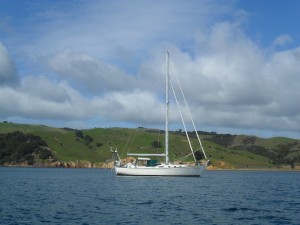
Picture: Port Bourail nice, quiet.
Unfortunately at 0900 the sun is not high enough to give a clear view into the water. We therefore navigated using the beacons, our past track and the depth sounder. And we proceeded out of Ouano lagoon slowly! All went well although at one point approaching the last green beacon the depth started to decrease rapidly as we approached the edge of the channel. We swiftly engaged reverse to slow down and steered back to the channel; the depth returned. With some relief we cleared the Ouano lagoon and headed to the reef entrance, the Passe d’Ouari, some 3 miles away. On the way out we could see the wild life; Helen counted half a dozen turtles and two sea snakes in the water.
The passe is not marked with beacons and is about 1 ¼ nm long. However, it is about half a mile wide, straight and we had good waypoints. The ocean breakers were also clearly visible on the seaward edge, providing a good visual reference. We therefore lined up and headed through. As usual we were looking ahead and particularly at the water. As we approached the passe we spotted white water near the middle. We are very sensitive to white water near reefs as it often indicates the presence of shallow water causing the swell or waves to break. Of course it can also just be wind-blown waves breaking. However, the wind was very light and, worse, this white water was occasional but in about the same place. The reef edges with their near constantly breaking waves were clearly visible. This was different. We drew closer; fortunately the white water was ahead but about 100m or so to our port side; sowe would miss it by a safe distance. As we approached we could see the white water was not a breaking wave, it was a plume of spray. Closer and there it was, a large head, followed by a plume, followed by a dark body, then a fin, then more dark body. The whole sequence took some 5 to 6 seconds. This was a large whale, probably a Humpback by the shape of the head. And it looked like it was just lying on or near the surface. Then next to it, another plume, body, fin, body. Smaller this time – probably only just bigger than Tai Mo Shan (!). A mother and baby whale lying asleep in the passe! We passed them some 100m or so away, they were not bothered.
As with the previous passage, the day started with light wind which then built steadily. We therefore started motor sailing and ended up sailing downwind, no motor. The coast seemed largely deserted. Indeed, there was only one break in the reef charted and this led, well to an extremely shallow deserted bay. Otherwise the reef simply extended 2 to 4 nm from the coast limiting our view of the land. Holding about one nm off the reef we could only really clearly see the constantly breaking waves.
The gap in the reef leading to Port Bourail is not marked, but is some 1.6nm wide and flanked by noticeable surf. This entrance was therefore no problem. Of course, it was not as easy as that as the wide entrance allows the ocean swell to roll right into Bourail Bay making it an unsuitable anchorage. Instead we diverted off to the estuary of the River Nessadiou. Here the river had cut a channel into a muddy bay, past a headland, and through the inner reef to join the outer pass. This provided much more shelter. Of course, it also meant, in effect two more reef entrances. The first was between the coastal inner reef to the south and a triangular shaped reef extending out from the point separating Bourail Bay and the bay formed by the River Nessadiou. This gap was maybe 1/3 nm (approximately 600 metres) wide and not marked; it was a case of using the waypoints from our cruising guide, the chart and our eyes. Just as well we had arrived at about 3pm with good sunlight! We motored steadily through the second entrance. Then the third. This was between the headland/ triangular reef and a headland to the south of the anchorage. The guide warned of a shallow shelf extending off this headland which was so steep to that our depth sounder would not give any warning. The gap was about 150m wide with no marks. The chart also seemed a little inaccurate as it did not exactly match our Google Earth view. We proceeded very cautiously, safely made the (small) anchorage and anchored. The anchorage was indeed sheltered from the wind and wave, but what an entrance! We deserved a wine that night.
The next day, Saturday, we decided to head to Port Bourail. The river there looked navigable so we planned to head up it, perhaps even to the town of Bourail, some 6km upriver. The guide noted a Dive Centre at the river entrance, so it would be good to call in there to chat and seek local knowledge. We therefore readied the dinghy with extra fuel, radio and water. Mid-morning and off we went. Initially we intended to cross the triangular reef off the northern headland. However as we left Tai Mo Shan we realised that the reef rapidly got shallow and indeed dried very extensively; we would have to go around. This reef extended out nearly a mile from the headland, so it was quite a detour. Off we went trying to stay close to the fringe of the reef. The water was very clear with visibility down to say 10m. The sea bed was covered in several different types of living, vibrant coloured coral. This was very pretty, indeed awesome to look at. However, it also meant the sea bed was not flat with significant depth changes close to the reef edge. We saw several columns of coral that rose well over 5m near vertically to nearly broach the surface as well a more normal depth changes that would bring the sea bed from out of sight to perhaps 2 or 3 metres below the dinghy. As a precaution we pushed further out away from the reef. Fortunately the day was calm. It was still slightly strange holding some 200 metres off where the small waves were breaking on the reef edge. We rounded the seaward end of the reef and headed into Bourail Bay. Here the chart indicated that sand/mud stopped the coral growth leading to a more normal steep drop at the edge of the reef. We could stay closer to the reef edge, and then the headland.
Bourail Bay is fringed by a large beach with the River Nera entering the sea at the south eastern corner. The river had a small bar, where the sea becomes shallow due to the sediment from the river building up as it reaches the sea. Normally river bars are approached with caution as the shallow water causes waves to rise up and break. In addition, the sand/mud often shifts so navigation is difficult, and the currents can be fearsome. Bars such as the Manukau and Kaipara bars in New Zealand have claimed many ships over the years. Of course this was only a small bar caused by a minor river entering a bay. There was no real hazard to us, but it was interesting to see the change in depth and resultant build up of (small) waves breaking on the bar edges. The bar was shallow but we could easily cross in the dinghy with the motor raised slightly. And once in the river the depth resumed (our guide said a metre of so).
Having crossed the bar we entered the river and headed to a clutch of buildings and a small slipway ashore. We landed and walked the small beach to the buildings. They did contain both the Dive Centre and a Surf Club. Unfortunately both were securely closed, locked and shuttered! We walked a little way; the place appeared deserted. Ah well, back to the dinghy and upriver we went. Initially there was good depth and we passed a few areas used for launching boats; the slip in to the water and adjacent parked cars and trailers were readily apparent. After perhaps a km the river split. We took what appeared to be the major channel, which passed a boat launching area and then ended in mangroves. Back to the minor channel which consisted of many shoals barely deep enough for us to cross. Given the extensive dinghy trip, the deserted nature of the place and our broken rowlock we decided not to risk damage to the engine and headed back to the Dive Centre buildings. Ashore again we wandered more extensively.
We soon saw another surf club, securely locked. Further in there were several houses, most quite large with extensive gardens/land and all in good condition. In fact the whole place was very tidy, just eerily quiet. We might have seen 4 cars in the hour or so we wandered around. We concluded that this was a village of holiday homes and, seeing as it was winter, few were occupied despite the weather being pleasant.
Once back at Tai Mo Shan we explored the bay caused by the River Nessadiou. It was shallow mud and largely mangrove lined but had a launch point in the distance on the north side of the river that was used by several small motor boats (runabouts) that passed us. There was also a launch point closer by on the south side. We landed there and talked to a couple of people who had just put their tinny boat on it trailer and were now cleaning fish. The usual limited French/English and extensive arm waving applied. We learned that the couple had only caught 2 reasonable sized fish (we did not recognise the type), on line with squid cut bait. Usually they caught more (!) sitting just off the reef. They lived about 6 km away (not in Bourail) and it was convenient to launch here. They liked fishing, especially when the weather was good as it was that day! As we talked another boat pulled up with 4 young men in it. The skipper was the cousin of the couple!
That night we were strangely grateful for the lights from the two houses on the bluff above the anchorage and a couple more houses in the distance on the coast.
The next day we would head off for the 40 nm trip to Moue and the adjacent village of Neopolini. We had an interesting decision to make on when to leave …
Picture: Port Bourail nice, quiet.
Comments
| Vessel Name: | Tai Mo Shan |
| Vessel Make/Model: | North Cape 43 (Ed Brewer) |
| Hailing Port: | Auckland, NZ |
| Crew: | Paul and Helen Dickinson |
| About: | |
| Extra: | Tai Mo Shan was built in Hong Kong in 1980 by Emsworth Ltd of Athang Hau. Her name translates to 'Big Hat Mountain' which overlooks the boat yard. We prefer 'Tai Mo Shan'; something is lost in translation. Tai Mo Shan has a proud tradition of cruising the Pacific, and we intend to continue that. |
Gallery not available
Who: Paul and Helen Dickinson
Port: Auckland, NZ