
Tai Mo Shan
05 December 2022 | Tasman Sea
06 January 2021 | Moreton Bay, Australia
23 October 2020 | Brisbane, Australia
15 October 2020 | Gladstone, Australia
12 October 2020 | Mackay, Australia
07 October 2020 | Mackay, Australia
03 October 2020 | Townsville Australia
25 September 2020 | Magnetic Island, Australia
20 September 2020 | Hinchinbrook Island, Australia
12 September 2020 | Great Palm Island, Australia
12 September 2020 | Horseshoe Bay, Magnetic Island, Australia
06 September 2020 | Townsville, Australia
18 August 2020 | Townsville, Australia
12 August 2020 | Hook Reef, Australia
10 August 2020 | Hook Island, Australia
10 August 2020 | South Molle Island, Australia
06 August 2020 | Airlie Beach, Australia
06 August 2020 | Cid Harbour, Whitsunday Group, Australia
29 July 2020 | Shaw Island, Australia
29 July 2020 | Goldsmith Island, Australia
Passage to Sydney – Down to the Gold Coast Sep 19
05 October 2019 | Gold Coast, Queensland
Paul Dickinson
Wednesday 25th September, 1115 all the preparation done, and so we slipped from our berth at East Coast Marina. It was a nice sunny day, but with only a light Easterly breeze. Still we had to motor through the marina to the end of the entrance channel anyway. Of course, the main sail was up as soon as possible, with the Yankee unfurled soon after. It was then a slow into wind sail through the gap between Green Island and the mainland at Wellington Point. The channel is marked with 2 posts, just as well as there are significant reefs and shoals extending from each land, and the posts do seem a way offshore. Still, we easily gained upwind to pass safely through. We then headed off the wind a few degrees, and so gained speed.
We had a nice reach slightly into wind to Peel Island. Interestingly there was a catamaran a mile or so ahead of us. Two boats going in the same direction – that’s the definition of a boat race! And so we trimmed sail for best speed and chased. Unfortunately we did not catch the catamaran, but as we rounded the corner to turn east to Horseshoe Bay, Peel Island the catamaran was about 100 metres ahead of us. As we hardened up into the wind to sail to the anchorage, the catamaran furled its sails and motored. Well we had taken a mile out of the lead during the 8 mile reach; we had a moral victory! 1400, and we were anchored in the pleasant anchorage, The (easy) first leg was over.
Overnight we had been surprised by the amount of water movement in the anchorage. Whilst we were sheltered from the wind, the many ferries, and other boat traffic, heading to and from Stradbroke Island created significant wake. In addition, the tide flow past Peel Island is strong, and that creates a fair bit of motion on the surface. Still Thursday 26th September and we were us early ready to head south down the inland waterway to the Gold Coast.
The trip down the inland waterway is some 34 miles. The vast majority is down through narrow, shallow channels between the low lying sand islands and mangroves. The tide features heavily in both giving a boost in speed due to the currents (the narrow waterways seem like rivers) and in giving us sufficient water to ensure our keel clears the sea bed. As it was the tide tables showed high tide at Brisbane at 0720, and Gold Coast Seaway at 0605 and 1826. The channels through the waterway are well marked with many beacons. However, the vast majority are unlit, so travelling the waterway at night was not really an option. Taking the waterway in daylight inevitably meant we would encounter low tide, so we would have to be careful!
So 0700 and we raised anchor in another beautiful clear morning. The forecast was for light to moderate winds in the Northern quadrant which would nicely push us along. Initially we had a good sail with an East wind abeam of us. Unfortunately as we entered the first channel Stradbroke Island, to our east, shielded us from the wind. As we result had to motor sail, and indeed, we motorsailed the whole way.
We had expected the ebb tide to be against us from the first big island (MacCleay Island) at about 0800 until at least 2/3 of the way. However, to our surprise, and pleasure, we seemed to have about one knot of current with us all the way. A very welcome bonus.
The initial stretches of the waterway are past inhabited islands. Indeed, these islands have a lot of very nice houses, boats on moorings, and nice cars. This is not a deprived neighbourhood! And the ferries run frequently; vehicle ferries and high speed passenger craft. The skippers are well used to navigating the narrow channels and we had no problems avoiding the traffic.
Quite rapidly we headed into the hinterlands. The islands are low lying with mangrove margins. The mainland is rural, usually with, yes, mangroves. We are not far from Brisbane in miles, but very distant in feel. Here the main channel is quite wide. Unfortunately the navigable channel is far less broad, and one has to follow the marks carefully; a mistake would rapidly result in a grounding in the soft mud. With the outgoing tide, this would lead to a long delay. As it was by 1000, coming up to half way, we noticed that we frequently had less than 1m of water under the keel!
We passed the settlement of Steiglitz without a problem. The channel passes by some very nice seafront properties, each with its own jetty. Indeed, we had to stay close to these jetties as the channel clearly shallowed out rapidly. The water was muddy so we could not see down any depth at all. However, we could eaisiy discern the current from the water surface. And shallow water has a distinctive look, not least as the wake from passing boats causes breaking wavelets.
We continued onwards past more mangroves and occasional moored boats to the next settlement of Jacobs Well. At least the channel is more defined here, with greater depths. There are also many moored vessels on either side of the channel. The yachts at least gave us some comfort that they had reasonable depth. However, some of the other craft, including houseboats clearly drew very llttle water. That said, we did pass some substantial work barges, complete with braces of concrete trucks on them. Fortunately the channel was wide enough for us to pass safely although it was an interesting feeling being in a narrow channel with moored boats and shallow banks either side and seeing a large barge heading towards us.
Past Jacobs Well and the channel broadened and got shallow, only 0.5 metres of water under the keel. To add to the fun there is a yellow marker mid channel indicating, we believe the nature reserve. So dodging that, and the increasing number of small boats, one eye on the depth sounder we pushed on. A little further the channel heads to the southern bank and is marked by a series of posts. Another strange feeling; 90% of the waterway width is too shallow for us! As we continued onwards one of the red markers has a sign ‘Shoals’ under it. Sure enough, we are mid channel and bump! We touch the bottom, but glide over. Phew! A few seconds later and bump again. This time we stop! So here we are mid channel, grounded. The depth sounder shows zero depth. However, as we apply maximum power and turn the sounder indicates depth! A few minutes of full power, frantic turning of the wheel to wriggle the boat, full reverse power to spin her, main sail pulled tight to lean, and we move forwards. The depth sounder shows depth, we come free and quickly throttle back to avoid hitting the other side of the channel! Back aligned to the channel and we continue; we almost have one metre under the keel!
Now we came to the place we anticipated trouble! There is a junction where the eastward channel branches. One channel goes north east to the treacherous Jumping Pin bar that opens to the sea, the other channel heads south to the Gold Coast. The confluence also marks significant changes in the current (which allows the water to drop sediment), and lots of shallow water, and shallow channels. The channels are marked guiding us around a tight turn of some 135 degrees before turning 45 degrees the opposite direction. We carefully manoeuvred around, the other traffic would just have to dodge us. Fortunately the traffic was light, and the skippers of the launches seemed to understand that we had a lot more underwater than them. Around the corner and Helen called out ‘ there is very shallow water very close to starboard’. Paul’s response was ’there is very shallow water very close to port!”.
We made it in to the wide channel. We are certain we had less than one metre under the keel for the next 2 nm. Indeed, we are pretty sure we had less than 0.5 metres for this distance. Still we did not touch and gradually the depth increased as the tower blocks of the Gold Coast came into view on the horizon.
We were now less than 10 miles from the Gold Coast and the water becomes jetski city. There were loads of them, all travelling quickly. However, size has a certain quality, and they all gave us a wide berth.
A few miles further on and we came across the first real developments. Paradise Point (according to the chart) does not have big, posh houses. Oh no. It has palaces! Serious huge residences with all the mod cons.
Onwards following the channel markers, dodging mud and sand banks (some of which were clearly visible). There is now more traffic, motor boats, occasional yachts, and yes, jet skis. Still the channel is fairly shallow, although we do tend to have more than one metre under the keel. The palaces are now replaced by simply very large, nice houses, and the occasional apartment blocks. Still, to the east, Stradbroke Island continues as a nature reserve with scrub, sand, occasional sunbathers, wildlife (presumably) and not a lot else.
As we approach the end of the waterway the channel marker posts are replaced by substantial concrete pillars with red or green metal ‘flags’ showing which side of the channel they indicate. The channel widens somewhat and we also have some reasonable depth. We took the opportunity to turn to wind and lower or main sail. We would pass the Seaway under motor only.
The seaway is a cut through the coastal sandbank from the inland water to the sea. Given that the Gold Coast channels and canals extend up to 10 miles to the south, and Jumping Pin is some 12 miles to the North, a lot of water flow through this 250m wide channel. We were expecting significant current (our last visit saw 3 to 4 knots!). However this time it was barely noticeable. It was now about 1300, with low tide expected at 1147, we can only conclude that there is a delay in the ebb tide current. So, with some relief we motored past the Seaway and on another 500m or so to the entrance to the Marine Stadium, loving known as ‘Bums Bay’ as it offers free anchoring for up to a week. The anchorage in the stadium was, as is often the case, full of craft. Whilst we could probably find a spot, it would be tight. Instead we opted to anchor just before the entrance. This suffers slightly from wake as boats pass by but offers much more anchoring and swinging room.
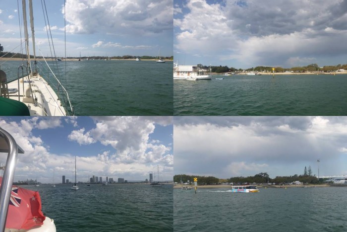
So at 1325 we anchored, and looked around. This is a nice spot; the Gold Coast with its towering hotels is a few miles to the south, with Seaworld in between. The East sees the inland waterway, complete with shoals before the other shore, some mile away, shows its set of hotels and skyscrapers. Closer in to the north is the sand spit separating the stadium from the waterway. This beach of clean white sand has a number of sunbathers. Then to the east is the Gold Coast spit. Another sandy beach with sunbathers. And behind is a sizeable car park with access to a couple of boat ramps, and pelicans roosting on the high level lights. Given a Gin and Tonic (with ice and a slice) one can easily spend an afternoon watching the activities; all manner of watercraft from superyachts to stand up paddle boards, the ubiquitous jetskis, water taxis, the rather odd amphibious ‘duck’ ferrying people and, over the waterway wind and kite surfers. And the occasional dolphin to add to the excitement.
The ice has melted, pass another Gin and Tonic!
Picture – the view from the Anchorage.
We had a nice reach slightly into wind to Peel Island. Interestingly there was a catamaran a mile or so ahead of us. Two boats going in the same direction – that’s the definition of a boat race! And so we trimmed sail for best speed and chased. Unfortunately we did not catch the catamaran, but as we rounded the corner to turn east to Horseshoe Bay, Peel Island the catamaran was about 100 metres ahead of us. As we hardened up into the wind to sail to the anchorage, the catamaran furled its sails and motored. Well we had taken a mile out of the lead during the 8 mile reach; we had a moral victory! 1400, and we were anchored in the pleasant anchorage, The (easy) first leg was over.
Overnight we had been surprised by the amount of water movement in the anchorage. Whilst we were sheltered from the wind, the many ferries, and other boat traffic, heading to and from Stradbroke Island created significant wake. In addition, the tide flow past Peel Island is strong, and that creates a fair bit of motion on the surface. Still Thursday 26th September and we were us early ready to head south down the inland waterway to the Gold Coast.
The trip down the inland waterway is some 34 miles. The vast majority is down through narrow, shallow channels between the low lying sand islands and mangroves. The tide features heavily in both giving a boost in speed due to the currents (the narrow waterways seem like rivers) and in giving us sufficient water to ensure our keel clears the sea bed. As it was the tide tables showed high tide at Brisbane at 0720, and Gold Coast Seaway at 0605 and 1826. The channels through the waterway are well marked with many beacons. However, the vast majority are unlit, so travelling the waterway at night was not really an option. Taking the waterway in daylight inevitably meant we would encounter low tide, so we would have to be careful!
So 0700 and we raised anchor in another beautiful clear morning. The forecast was for light to moderate winds in the Northern quadrant which would nicely push us along. Initially we had a good sail with an East wind abeam of us. Unfortunately as we entered the first channel Stradbroke Island, to our east, shielded us from the wind. As we result had to motor sail, and indeed, we motorsailed the whole way.
We had expected the ebb tide to be against us from the first big island (MacCleay Island) at about 0800 until at least 2/3 of the way. However, to our surprise, and pleasure, we seemed to have about one knot of current with us all the way. A very welcome bonus.
The initial stretches of the waterway are past inhabited islands. Indeed, these islands have a lot of very nice houses, boats on moorings, and nice cars. This is not a deprived neighbourhood! And the ferries run frequently; vehicle ferries and high speed passenger craft. The skippers are well used to navigating the narrow channels and we had no problems avoiding the traffic.
Quite rapidly we headed into the hinterlands. The islands are low lying with mangrove margins. The mainland is rural, usually with, yes, mangroves. We are not far from Brisbane in miles, but very distant in feel. Here the main channel is quite wide. Unfortunately the navigable channel is far less broad, and one has to follow the marks carefully; a mistake would rapidly result in a grounding in the soft mud. With the outgoing tide, this would lead to a long delay. As it was by 1000, coming up to half way, we noticed that we frequently had less than 1m of water under the keel!
We passed the settlement of Steiglitz without a problem. The channel passes by some very nice seafront properties, each with its own jetty. Indeed, we had to stay close to these jetties as the channel clearly shallowed out rapidly. The water was muddy so we could not see down any depth at all. However, we could eaisiy discern the current from the water surface. And shallow water has a distinctive look, not least as the wake from passing boats causes breaking wavelets.
We continued onwards past more mangroves and occasional moored boats to the next settlement of Jacobs Well. At least the channel is more defined here, with greater depths. There are also many moored vessels on either side of the channel. The yachts at least gave us some comfort that they had reasonable depth. However, some of the other craft, including houseboats clearly drew very llttle water. That said, we did pass some substantial work barges, complete with braces of concrete trucks on them. Fortunately the channel was wide enough for us to pass safely although it was an interesting feeling being in a narrow channel with moored boats and shallow banks either side and seeing a large barge heading towards us.
Past Jacobs Well and the channel broadened and got shallow, only 0.5 metres of water under the keel. To add to the fun there is a yellow marker mid channel indicating, we believe the nature reserve. So dodging that, and the increasing number of small boats, one eye on the depth sounder we pushed on. A little further the channel heads to the southern bank and is marked by a series of posts. Another strange feeling; 90% of the waterway width is too shallow for us! As we continued onwards one of the red markers has a sign ‘Shoals’ under it. Sure enough, we are mid channel and bump! We touch the bottom, but glide over. Phew! A few seconds later and bump again. This time we stop! So here we are mid channel, grounded. The depth sounder shows zero depth. However, as we apply maximum power and turn the sounder indicates depth! A few minutes of full power, frantic turning of the wheel to wriggle the boat, full reverse power to spin her, main sail pulled tight to lean, and we move forwards. The depth sounder shows depth, we come free and quickly throttle back to avoid hitting the other side of the channel! Back aligned to the channel and we continue; we almost have one metre under the keel!
Now we came to the place we anticipated trouble! There is a junction where the eastward channel branches. One channel goes north east to the treacherous Jumping Pin bar that opens to the sea, the other channel heads south to the Gold Coast. The confluence also marks significant changes in the current (which allows the water to drop sediment), and lots of shallow water, and shallow channels. The channels are marked guiding us around a tight turn of some 135 degrees before turning 45 degrees the opposite direction. We carefully manoeuvred around, the other traffic would just have to dodge us. Fortunately the traffic was light, and the skippers of the launches seemed to understand that we had a lot more underwater than them. Around the corner and Helen called out ‘ there is very shallow water very close to starboard’. Paul’s response was ’there is very shallow water very close to port!”.
We made it in to the wide channel. We are certain we had less than one metre under the keel for the next 2 nm. Indeed, we are pretty sure we had less than 0.5 metres for this distance. Still we did not touch and gradually the depth increased as the tower blocks of the Gold Coast came into view on the horizon.
We were now less than 10 miles from the Gold Coast and the water becomes jetski city. There were loads of them, all travelling quickly. However, size has a certain quality, and they all gave us a wide berth.
A few miles further on and we came across the first real developments. Paradise Point (according to the chart) does not have big, posh houses. Oh no. It has palaces! Serious huge residences with all the mod cons.
Onwards following the channel markers, dodging mud and sand banks (some of which were clearly visible). There is now more traffic, motor boats, occasional yachts, and yes, jet skis. Still the channel is fairly shallow, although we do tend to have more than one metre under the keel. The palaces are now replaced by simply very large, nice houses, and the occasional apartment blocks. Still, to the east, Stradbroke Island continues as a nature reserve with scrub, sand, occasional sunbathers, wildlife (presumably) and not a lot else.
As we approach the end of the waterway the channel marker posts are replaced by substantial concrete pillars with red or green metal ‘flags’ showing which side of the channel they indicate. The channel widens somewhat and we also have some reasonable depth. We took the opportunity to turn to wind and lower or main sail. We would pass the Seaway under motor only.
The seaway is a cut through the coastal sandbank from the inland water to the sea. Given that the Gold Coast channels and canals extend up to 10 miles to the south, and Jumping Pin is some 12 miles to the North, a lot of water flow through this 250m wide channel. We were expecting significant current (our last visit saw 3 to 4 knots!). However this time it was barely noticeable. It was now about 1300, with low tide expected at 1147, we can only conclude that there is a delay in the ebb tide current. So, with some relief we motored past the Seaway and on another 500m or so to the entrance to the Marine Stadium, loving known as ‘Bums Bay’ as it offers free anchoring for up to a week. The anchorage in the stadium was, as is often the case, full of craft. Whilst we could probably find a spot, it would be tight. Instead we opted to anchor just before the entrance. This suffers slightly from wake as boats pass by but offers much more anchoring and swinging room.
So at 1325 we anchored, and looked around. This is a nice spot; the Gold Coast with its towering hotels is a few miles to the south, with Seaworld in between. The East sees the inland waterway, complete with shoals before the other shore, some mile away, shows its set of hotels and skyscrapers. Closer in to the north is the sand spit separating the stadium from the waterway. This beach of clean white sand has a number of sunbathers. Then to the east is the Gold Coast spit. Another sandy beach with sunbathers. And behind is a sizeable car park with access to a couple of boat ramps, and pelicans roosting on the high level lights. Given a Gin and Tonic (with ice and a slice) one can easily spend an afternoon watching the activities; all manner of watercraft from superyachts to stand up paddle boards, the ubiquitous jetskis, water taxis, the rather odd amphibious ‘duck’ ferrying people and, over the waterway wind and kite surfers. And the occasional dolphin to add to the excitement.
The ice has melted, pass another Gin and Tonic!
Picture – the view from the Anchorage.
Comments
| Vessel Name: | Tai Mo Shan |
| Vessel Make/Model: | North Cape 43 (Ed Brewer) |
| Hailing Port: | Auckland, NZ |
| Crew: | Paul and Helen Dickinson |
| About: | |
| Extra: | Tai Mo Shan was built in Hong Kong in 1980 by Emsworth Ltd of Athang Hau. Her name translates to 'Big Hat Mountain' which overlooks the boat yard. We prefer 'Tai Mo Shan'; something is lost in translation. Tai Mo Shan has a proud tradition of cruising the Pacific, and we intend to continue that. |
Gallery not available
Who: Paul and Helen Dickinson
Port: Auckland, NZ