
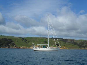
Tai Mo Shan
05 December 2022 | Tasman Sea
06 January 2021 | Moreton Bay, Australia
23 October 2020 | Brisbane, Australia
15 October 2020 | Gladstone, Australia
12 October 2020 | Mackay, Australia
07 October 2020 | Mackay, Australia
03 October 2020 | Townsville Australia
25 September 2020 | Magnetic Island, Australia
20 September 2020 | Hinchinbrook Island, Australia
12 September 2020 | Great Palm Island, Australia
12 September 2020 | Horseshoe Bay, Magnetic Island, Australia
06 September 2020 | Townsville, Australia
18 August 2020 | Townsville, Australia
12 August 2020 | Hook Reef, Australia
10 August 2020 | Hook Island, Australia
10 August 2020 | South Molle Island, Australia
06 August 2020 | Airlie Beach, Australia
06 August 2020 | Cid Harbour, Whitsunday Group, Australia
29 July 2020 | Shaw Island, Australia
29 July 2020 | Goldsmith Island, Australia
Passage to Sydney – Down the Australian Coast Sep Oct 19
07 October 2019 | Sydney, Australia
Paul Dickinson
Unfortunately Helen contacted a nasty virus which laid her low for a few days. As a result we remained on board for the next 3 days. This presented us with the opportunity to watch the comings and goings. Paul also practiced the guitar, a move that we are sure ensured no one anchored near us, and all other craft hurried by! Still we did have a visitor. A fellow Kiwi, Dave, who now lives in Australia and had a small yacht anchored in ‘Bums Bay’ came by in his tender. The afternoon was spent talking sailing, life on the Gold Coast, and more sailing!
Monday 30th September and Helen had largely recovered from her virus. We also had a reasonable weather window with Easterly winds, swinging Northerly after a couple of days. The Friday was forecast to have a nasty weather change with a swing to strong Southerlies. However, given the passage was 430 or so nm we should have been in Sydney Harbour by then.
The high tide at Gold Coast Seaway was predicted to be at 0914. Being in the seaway at this time should give us maximum keel clearance (not really a problem) and minimum current (and so minimum water turbulence). This allowed us a gentlemanly breakfast with us weighing the anchor at 0905. 15 minutes later and we were motoring in the seaway. And the current was flowing against us! There was nothing else to do but put on maximum revs and push through at 4.5 to 5 knots (which indicates up to 2 knots of tide). Fortunately, the seaway is not too long.
One of the Notices to Mariners advises of shoaling at the end of the seaway. Whilst the chart shows some 6m depth at low tide, the shoaling had reduced this to about 4m. There was maybe 1m of swell which, of course, reduces keel clearance. We were glad to be armed with this knowledge as we passed over the shoaling with some 3m or so to clear.
Once some 0.5nm away from the seaway we raised sails. The forecast easterly wind was in fact south easterly, and we wanted to go to the South East to head out to drop into the East Australian Current. This current flows down the Australian coast at, apparently, between 2 and 4 knots, so would provide areal boost to us. Those who have seen the film ‘Finding Nemo’ will be familiar with this maritime super highway. But, of course, a south easterly wind meant we would have to tack off the coast, taking some time to make the 20 to 30 nm into wind. Instead we opted to sail close to the wind along the coast. The coast is generally southwards, but with a touch of east to avoid a series of headlands.
The first headland was Tweed Heads. This has the ominously names Point Danger, along with the equally ominous Danger Reefs extending some 3½ nm offshore. Driving hard into wind we made progress, but it was not enough; we would just about clear Tweed Heads but not the reefs. The reefs are charted with some 3 to 5 m of water over them, but we did really not want to chance it. So, it was on with the motor to help the sails and lift us up a few degrees to windward. We cleared the reefs with about ¼ nm to spare. Interestingly a very sporty race boat had left soon after us. She was about 50 feet long, had AIS, and we could see the black composite (i.e. high performance and very expensive) sails closing on us. Our speed typically 5 knots, hers up to 9! However, she was also pointing lower (i.e. off the wind) than us. We watched her track on AIS as she just about cleared Tweed Heads. We think the skipper then looked at his charts (!) as suddenly the boat turned 90 degrees to seaward to avoid the first reef. We watched the zig zag course over the next 15 minutes as the boat manoeuvred safely past the reefs. We imagine there was some consternation aboard.
Past Tweed Heads we could ease off the wind a few degrees and still clear the next major headland, Byron Heads, some 28 nm away. A gradual wind shift eastwards also helped and we made a good 5 to 6 knots. The race boat, presumably now calm aboard, eventually stormed past us a dusk fell.
Overnight the wind increased and became somewhat gusty. It remained south east to easterly and so we were still pushing into wind. As a result we reefed both the Main and Yankee. Early morning and the wind dropped back in strength and so we could use full Yankee. The night was dominated by the need to dodge the many fishing boats on the water. These were always well lit, and so easy to spot visually. However, they did not have AIS, and, as they were fishing, did not tend to follow a predictable course. We had to make a few course changes to avoid them, but overall did not have a problem. Indeed, having boats to focus on kept us alert all night! We also saw a few coastal ships, but with AIS we could easily avoid these.
Tuesday morning saw a further drop in the wind to the extent that under full sail we still had to have the motor in fast tickover (1250 rpm) to keep progress at 5 knots. A bit of excitement as at 1000 we made a significant course change to avoid the cargo ship ‘Gas Defiance’, missing by 0.8nm; well, she was larger than us!
The wind continued to abate throughout the day until at about 1400 it was light enough for us to make a course change to intercept the East Australian Current. At this point the current was only some 5 nm or so further offshore, so we decided to take advantage. So, sails away and motoring at an economical 1750 rpm we pushed offshore at 4 knots or so. At about 1515 we could see the increased drift southwards on our GPS. We were in the current at a depth of about 150m. Another course change saw us return to the southerly heading with a speed over ground of about 5 knots, a moderate but useful boost.
The day progressed with the wind remaining behind us but of variable strength. It was a case of main sail out but prevented. We did not use the Yankee much as the swell and wave motion caused it to collapse and even back wind regularly. By contrast the more firmly supported Main would at least remain full. Our speed over the ground also varied from 4 to over 6 knots. Occasionally the wind would fail almost completely and we would be forced to start the motor and motor sail (albeit at moderate revs).
And so it continued through Wednesday. The number of fishing boats dropped off markedly as we headed south. But then the number of ships increased. We concluded that Newcastle is indeed a very busy port!
Being in the current was not as we expected. We had envisaged a sort of river in the sea, with a pretty consistent flow. Instead the current seems to be a swirling turbulent mass of water generally heading south. We noticed that our speed over the ground varied quite considerably despite our water speed staying quite consistent (and only changing with the wind). Another interesting phenomenon was the effect of the current on our depth sounder. Most of the time we were in oceanic depths (i.e. over 1000m). Our depth sounder can reach up to about 250m before just displaying ’---‘. However, in the current we often got false bottom readings from 50 to 250m. We believe this was due to the isoclines, or layers of water at one temperature. Usually the water gradually gets colder as it gets deeper. However, we think the turbulent current made for sharper changes in water temperature, and this affected our sonar-driven depth sounder. We were reminded of those submarine war films where the sub skipper tries to hide below an isocline to avoid the ‘ping’ of the sonar!
Thursday morning saw us turn back towards the coast to make the run to Port Jackson (Sydney Harbour). The wind had dropped again and so we were motoring at 1750 rpm with the Main sail pulled in tight to act as a steadying sail. We expected to lose speed as we left the East Australian Current; however, we kept up a good pace all the way in. We can only conclude that the current pushes to Sydney (not as the Bureau of Meteorology forecast). Still we were grateful.
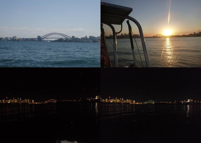
Approaching Sydney we could, of course, see buildings on the horizon, but the main feature was the large bluff of Quarantine Point to the North of the harbour entrance. This was really noticeable as we got closer, not least as we were heading straight towards the rocks at the base of the 100m high cliff! Our GPS track indicated that we would miss the bluff and nicely head into the harbour. Do we trust technology? Well, probably not. The issue was solved as Paul got transits on the land and buildings behind the bluff to confirm that we were indeed being swept past by a southerly current.
And so at a about midday we entered Sydney Harbour. The harbour consists of a main channel with several arms and bays. It is immediately noticeable that most of the harbour has a rocky shoreline, often with steep cliffs and slopes. The bays have very pleasant sandy shores. The chart confirms that the outer (and middle) harbour does indeed have reasonable depth; no mud flats here! There was also a lot of traffic. Many small runabouts were dashing about, or stationary with the occupants fishing. There were several yachts sailing, slowly, in the light winds. And, most noticeable of all, there were many ferries speeding across the water. Our research showed that Sydney has an active ferry network connecting the suburbs with a regular, rapid service. Here was the proof!
Motoring on, we dodged the traffic and dropped our Main Sail just of HMAS Sydney. We knew this as the point, Bradleys Head, has the lookout mast from an old World War One German battleship and a concrete plaque with ‘HMAS Sydney’ on it. From there we motored the last few hundred metres to Athol Bay.
Our cruising guide advised that there are courtesy moorings dotted about the harbour. These are coloured pink, and allow for free mooring of up to 24 hours. Great! We would use these. Of course, as we got to Athol Bay all of the 5 moorings were occupied! We would anchor in the 9m of water and wait. Sure enough, a little while later one of the vessels, a yacht, left. We weighed anchor and headed to the buoy. The buoy had a yellow label on it stating it was a public mooring with a time limit of 2 hours. We looked again, yes, 2 hours. Again, no, the ‘4’ had not been erased by the rope rubbing or general wear; the tag clearly stated 2 hours. That was no use to us, so we went back to our anchoring location, some 100m further offshore and anchored again. The New South Wales regulations allow anchoring for up to 28 days in any one location; far better!
And so here we are. Anchored in the middle of Sydney Harbour. To our north is Taronga Zoo, with a rocky shoreline, backed by small cliffs and green reserve. There are a couple of beaches with yellow sand. Very nice. A little further to the East is a ferry terminal serving the zoo. So we have a convenient secluded beach landing, a walk up some steps through a reserve, along the road to the terminal. And across the harbour is Sydney centre. One stop on the ferry to Circular Quay. Even better, we have a perfect view of the Opera House and Sydney Harbour Bridge. Not a bad anchorage after all.
And the stats. 424 nm run in 3 days, 4 hours and 20 minutes. So an average speed of 5.55 knots. That current did help after all!
Views of the Sydney Harbour Bridge from the anchorage.
Monday 30th September and Helen had largely recovered from her virus. We also had a reasonable weather window with Easterly winds, swinging Northerly after a couple of days. The Friday was forecast to have a nasty weather change with a swing to strong Southerlies. However, given the passage was 430 or so nm we should have been in Sydney Harbour by then.
The high tide at Gold Coast Seaway was predicted to be at 0914. Being in the seaway at this time should give us maximum keel clearance (not really a problem) and minimum current (and so minimum water turbulence). This allowed us a gentlemanly breakfast with us weighing the anchor at 0905. 15 minutes later and we were motoring in the seaway. And the current was flowing against us! There was nothing else to do but put on maximum revs and push through at 4.5 to 5 knots (which indicates up to 2 knots of tide). Fortunately, the seaway is not too long.
One of the Notices to Mariners advises of shoaling at the end of the seaway. Whilst the chart shows some 6m depth at low tide, the shoaling had reduced this to about 4m. There was maybe 1m of swell which, of course, reduces keel clearance. We were glad to be armed with this knowledge as we passed over the shoaling with some 3m or so to clear.
Once some 0.5nm away from the seaway we raised sails. The forecast easterly wind was in fact south easterly, and we wanted to go to the South East to head out to drop into the East Australian Current. This current flows down the Australian coast at, apparently, between 2 and 4 knots, so would provide areal boost to us. Those who have seen the film ‘Finding Nemo’ will be familiar with this maritime super highway. But, of course, a south easterly wind meant we would have to tack off the coast, taking some time to make the 20 to 30 nm into wind. Instead we opted to sail close to the wind along the coast. The coast is generally southwards, but with a touch of east to avoid a series of headlands.
The first headland was Tweed Heads. This has the ominously names Point Danger, along with the equally ominous Danger Reefs extending some 3½ nm offshore. Driving hard into wind we made progress, but it was not enough; we would just about clear Tweed Heads but not the reefs. The reefs are charted with some 3 to 5 m of water over them, but we did really not want to chance it. So, it was on with the motor to help the sails and lift us up a few degrees to windward. We cleared the reefs with about ¼ nm to spare. Interestingly a very sporty race boat had left soon after us. She was about 50 feet long, had AIS, and we could see the black composite (i.e. high performance and very expensive) sails closing on us. Our speed typically 5 knots, hers up to 9! However, she was also pointing lower (i.e. off the wind) than us. We watched her track on AIS as she just about cleared Tweed Heads. We think the skipper then looked at his charts (!) as suddenly the boat turned 90 degrees to seaward to avoid the first reef. We watched the zig zag course over the next 15 minutes as the boat manoeuvred safely past the reefs. We imagine there was some consternation aboard.
Past Tweed Heads we could ease off the wind a few degrees and still clear the next major headland, Byron Heads, some 28 nm away. A gradual wind shift eastwards also helped and we made a good 5 to 6 knots. The race boat, presumably now calm aboard, eventually stormed past us a dusk fell.
Overnight the wind increased and became somewhat gusty. It remained south east to easterly and so we were still pushing into wind. As a result we reefed both the Main and Yankee. Early morning and the wind dropped back in strength and so we could use full Yankee. The night was dominated by the need to dodge the many fishing boats on the water. These were always well lit, and so easy to spot visually. However, they did not have AIS, and, as they were fishing, did not tend to follow a predictable course. We had to make a few course changes to avoid them, but overall did not have a problem. Indeed, having boats to focus on kept us alert all night! We also saw a few coastal ships, but with AIS we could easily avoid these.
Tuesday morning saw a further drop in the wind to the extent that under full sail we still had to have the motor in fast tickover (1250 rpm) to keep progress at 5 knots. A bit of excitement as at 1000 we made a significant course change to avoid the cargo ship ‘Gas Defiance’, missing by 0.8nm; well, she was larger than us!
The wind continued to abate throughout the day until at about 1400 it was light enough for us to make a course change to intercept the East Australian Current. At this point the current was only some 5 nm or so further offshore, so we decided to take advantage. So, sails away and motoring at an economical 1750 rpm we pushed offshore at 4 knots or so. At about 1515 we could see the increased drift southwards on our GPS. We were in the current at a depth of about 150m. Another course change saw us return to the southerly heading with a speed over ground of about 5 knots, a moderate but useful boost.
The day progressed with the wind remaining behind us but of variable strength. It was a case of main sail out but prevented. We did not use the Yankee much as the swell and wave motion caused it to collapse and even back wind regularly. By contrast the more firmly supported Main would at least remain full. Our speed over the ground also varied from 4 to over 6 knots. Occasionally the wind would fail almost completely and we would be forced to start the motor and motor sail (albeit at moderate revs).
And so it continued through Wednesday. The number of fishing boats dropped off markedly as we headed south. But then the number of ships increased. We concluded that Newcastle is indeed a very busy port!
Being in the current was not as we expected. We had envisaged a sort of river in the sea, with a pretty consistent flow. Instead the current seems to be a swirling turbulent mass of water generally heading south. We noticed that our speed over the ground varied quite considerably despite our water speed staying quite consistent (and only changing with the wind). Another interesting phenomenon was the effect of the current on our depth sounder. Most of the time we were in oceanic depths (i.e. over 1000m). Our depth sounder can reach up to about 250m before just displaying ’---‘. However, in the current we often got false bottom readings from 50 to 250m. We believe this was due to the isoclines, or layers of water at one temperature. Usually the water gradually gets colder as it gets deeper. However, we think the turbulent current made for sharper changes in water temperature, and this affected our sonar-driven depth sounder. We were reminded of those submarine war films where the sub skipper tries to hide below an isocline to avoid the ‘ping’ of the sonar!
Thursday morning saw us turn back towards the coast to make the run to Port Jackson (Sydney Harbour). The wind had dropped again and so we were motoring at 1750 rpm with the Main sail pulled in tight to act as a steadying sail. We expected to lose speed as we left the East Australian Current; however, we kept up a good pace all the way in. We can only conclude that the current pushes to Sydney (not as the Bureau of Meteorology forecast). Still we were grateful.
Approaching Sydney we could, of course, see buildings on the horizon, but the main feature was the large bluff of Quarantine Point to the North of the harbour entrance. This was really noticeable as we got closer, not least as we were heading straight towards the rocks at the base of the 100m high cliff! Our GPS track indicated that we would miss the bluff and nicely head into the harbour. Do we trust technology? Well, probably not. The issue was solved as Paul got transits on the land and buildings behind the bluff to confirm that we were indeed being swept past by a southerly current.
And so at a about midday we entered Sydney Harbour. The harbour consists of a main channel with several arms and bays. It is immediately noticeable that most of the harbour has a rocky shoreline, often with steep cliffs and slopes. The bays have very pleasant sandy shores. The chart confirms that the outer (and middle) harbour does indeed have reasonable depth; no mud flats here! There was also a lot of traffic. Many small runabouts were dashing about, or stationary with the occupants fishing. There were several yachts sailing, slowly, in the light winds. And, most noticeable of all, there were many ferries speeding across the water. Our research showed that Sydney has an active ferry network connecting the suburbs with a regular, rapid service. Here was the proof!
Motoring on, we dodged the traffic and dropped our Main Sail just of HMAS Sydney. We knew this as the point, Bradleys Head, has the lookout mast from an old World War One German battleship and a concrete plaque with ‘HMAS Sydney’ on it. From there we motored the last few hundred metres to Athol Bay.
Our cruising guide advised that there are courtesy moorings dotted about the harbour. These are coloured pink, and allow for free mooring of up to 24 hours. Great! We would use these. Of course, as we got to Athol Bay all of the 5 moorings were occupied! We would anchor in the 9m of water and wait. Sure enough, a little while later one of the vessels, a yacht, left. We weighed anchor and headed to the buoy. The buoy had a yellow label on it stating it was a public mooring with a time limit of 2 hours. We looked again, yes, 2 hours. Again, no, the ‘4’ had not been erased by the rope rubbing or general wear; the tag clearly stated 2 hours. That was no use to us, so we went back to our anchoring location, some 100m further offshore and anchored again. The New South Wales regulations allow anchoring for up to 28 days in any one location; far better!
And so here we are. Anchored in the middle of Sydney Harbour. To our north is Taronga Zoo, with a rocky shoreline, backed by small cliffs and green reserve. There are a couple of beaches with yellow sand. Very nice. A little further to the East is a ferry terminal serving the zoo. So we have a convenient secluded beach landing, a walk up some steps through a reserve, along the road to the terminal. And across the harbour is Sydney centre. One stop on the ferry to Circular Quay. Even better, we have a perfect view of the Opera House and Sydney Harbour Bridge. Not a bad anchorage after all.
And the stats. 424 nm run in 3 days, 4 hours and 20 minutes. So an average speed of 5.55 knots. That current did help after all!
Views of the Sydney Harbour Bridge from the anchorage.
Comments
| Vessel Name: | Tai Mo Shan |
| Vessel Make/Model: | North Cape 43 (Ed Brewer) |
| Hailing Port: | Auckland, NZ |
| Crew: | Paul and Helen Dickinson |
| About: | |
| Extra: | Tai Mo Shan was built in Hong Kong in 1980 by Emsworth Ltd of Athang Hau. Her name translates to 'Big Hat Mountain' which overlooks the boat yard. We prefer 'Tai Mo Shan'; something is lost in translation. Tai Mo Shan has a proud tradition of cruising the Pacific, and we intend to continue that. |
Gallery not available
Who: Paul and Helen Dickinson
Port: Auckland, NZ