
Tai Mo Shan
05 December 2022 | Tasman Sea
06 January 2021 | Moreton Bay, Australia
23 October 2020 | Brisbane, Australia
15 October 2020 | Gladstone, Australia
12 October 2020 | Mackay, Australia
07 October 2020 | Mackay, Australia
03 October 2020 | Townsville Australia
25 September 2020 | Magnetic Island, Australia
20 September 2020 | Hinchinbrook Island, Australia
12 September 2020 | Great Palm Island, Australia
12 September 2020 | Horseshoe Bay, Magnetic Island, Australia
06 September 2020 | Townsville, Australia
18 August 2020 | Townsville, Australia
12 August 2020 | Hook Reef, Australia
10 August 2020 | Hook Island, Australia
10 August 2020 | South Molle Island, Australia
06 August 2020 | Airlie Beach, Australia
06 August 2020 | Cid Harbour, Whitsunday Group, Australia
29 July 2020 | Shaw Island, Australia
29 July 2020 | Goldsmith Island, Australia
We’re off – to Fraser Island Jun 20
14 June 2020 | Fraser Island, Australia
Paul Dickinson
The days leading up to Friday 12th June were a bit of a blur with preparations to depart, a work meeting, and a few social get-togethers to say goodbye. Finally Friday arrived, with a forecast of a light to moderate (10 to 15 knot) South Easterly changing to a light to moderate Easterly to North Easterly in the evening. This would push us along nicely as we headed north along the Sunshine coast.
Our plan was to sail up the coast, and then head to the West of Fraser Island, up the Great Sandy Strait. The strait would offer us shelter and anchorages from which to explore Fraser Island, a large sand island akin to Moreton and Stradbroke Islands. The only real navigational issue was that the straits southern entrance was guarded by the Wide Bay Bar. This bar is notorious and has claimed several craft and lives over the years. It is a comparatively long path through the bar, with swell from the south and east rising and breaking heavily on the sand banks. The gap through the bar is very mobile. As part of our passage planning Paul contacted the Tin Can Bay Coastguard who kindly provided up to date lat/long coordinates of the channel through the bar. Paul checked these with the latest survey carried out on 4th June 2020 provided in the latest Notice to Mariners issued by Maritime Safety Queensland. It is standard practice to time the entry through any bar to just before high tide. This provides an incoming tide to help damped down any breaking waves rolling in (entering on an ebb tide with an incoming swell or waves lead to the phenomenon of ‘wind against tide’ and higher, steeper seas – best avoided). Perhaps more importantly it provides us with the greatest water clearance under the keel.
As you can imagine, dropping off a wave so 16 ton of yacht lands on hard sand on its keel is really not great. So with some 110 nm to go to the bar we decided to sail up to Wide Bay, anchor off Double Island point and wait for a suitable time slot to cross the bay and the bar. Once over the bar we could easily find anchorage in the straits.
Our passage plan meant we could depart at mid morning, sail up the coast for 100 nm, taking 15 to 20 hours, and anchor in Wide Bay early morning. The forecast included a half moon rising quite late so we would have moonlight to anchor by.
Friday 12th June and we were up at 0700, breakfasted and boat prepared at 0830. We could then head to the marina buildings for a shower and goodbye to the marina office. Admin sorted we cast off at 0930 and headed to the fuel dock at the Moreton Bay Trailer Boat Club. The dock is quite tight but, with minimal wind, we are soon secure alongside and topping up our diesel (for the main engine) and petrol (for the outboard).
And so we were finally off. That forecast of a nice south easterly … well it was flat calm! We raised out main sail, more as a steadying sail than driving force, and motored on. A light southerly wind sprang up as we passed the islands near Manly but by then we were heading north at about 5 knots, so the 5 knot southerly meant we had zero apparent wind (i.e. the wind we felt on deck)! We pressed on, a favourable tide and clean hull meant we could keep the engine revolutions down to an economical 1750 and still maintain at least 5 knots over the ground as we went alongside the shipping channel. It was noticeable how little shipping there was. Normally we would see at least half a dozen ships transit the channel as we headed up Moreton Bay; that is why we plan to be alongside and not in the channel. This time we saw one ship enter Brisbane and one leave to anchor; none in the channel. We could only surmise this was an outcome of the global economic slowdown due to the Corona virus.
Dusk saw us at the northern entrance to Moreton Bay by Caloundra Heads. As we headed out into the Coral Sea a breeze sprang up from the South East. We had our Main sail and Yankee (foresail) set, and engine off, in double quick time; ah, sailing! As we turned to head north holding 2 to 4 nm off the coast the wind held and we made an easy 6 to 7 knots on a nice broad reach. We were the only boat on the water, and so with the boat trimmed, water hissing past, we could admire the (many) lights of the Sunshine Coast. Moolalaba was easily recognisable from the light on its headland and the high rise apartments. As the night wore on the wind moderated somewhat so our speed dropped to a reasonable 5 to 6 knots. Past Noosa the settlements thinned out and the land grew dark. Still as the moon rose we could make out the lighter coloured strip of sand forming that long beach.
The light on Double Island Point is visible from some 20 nm and so it’s flash provided an excellent navigation mark; it just takes nearly 4 hours to close! But close we did. We needed to turn off the wind and pass between the headland and Wolf Rock. Wolf Rock, lying a mile north of the point is on the chart, and described as an ‘awash’ rock. Unmarked, it lies just 0.4m below the surface at lowest astronomical tide and so presents quite a hazard. To be safe we dropped sails to the east of the point, turned downwind and motored into Wide Bay, holding about 1/4nm off the point.
Our target anchorage was in the south eastern corner of Wide Bay, hopefully gaining shelter from Double Island Point. The chart showed this as a fairly shallow area. However, our friends had explained that an occasional local phenomenon had occurred. The sands had shifted to form a sandbank a few hundred metres off the shore, which in turn formed a very sheltered lagoon behind. This lagoon was an excellent anchorage, but only for shallow draft vessels. It was too shallow for us to enter. The lagoon had formed; it is even visible on ‘Google Earth’. This meant the chart was inaccurate we had to be careful. As forecast the moon was up and, with only occasional clouds, we had good moonlight. However, the land and shoreline was still dark with only occasional lights inland. We motored on, eyes watching the depth sounder and probing the dark ahead. One light seemed closed than the others; it’s relative movement as we closed providing a vital clue. We drew closer and saw it was a sizeable yacht at anchor. We pressed on another 200 metres and then turned to the shore and dropped out anchor parallel to the other boat. 0400 and we were at anchor; 101 nm covered in some 17 ¾ hours.
Whilst Double Island Point offered shelter from the wind the swell just rolled around the point. As a result we had a ‘rolly’ night at anchor with quite a bit of motion. Still, we could sleep safely.
Saturday was a bright morning. We could see Wide Bay with its yellow sand cliffs leading to a beautiful sandy beach. And we could also see vehicles on the beach, dozens of them! The beach is a favourite for four wheel drivers. We could see the attraction of powering along a deserted beach, sand and spray flying, but this was more akin to Queen Street; it just needed traffic lights to complete!
High tide was forecast for the Wide Bay Bar for 1458. Ideally we wanted to enter the bar some 1½ hours before high tide. We were anchored about 8nm from the entry point, and so needed to depart at about 1200. 1155 saw us raising anchor and heading across the bay. There was a light south easterly allowing us to raise sails and use the engine to assist in holding a steady 5 knots. As we departed we called the coastguard on our radio. A problem; our call was distorted and difficult to read. We reverted to mobile phone and took the precaution of letting the coastguard know we would be crossing the bar; they would keep a watch. As we neared the entry point we dropped sails to allow us maximum manoeuvrability and called up coastguard. Our main radio was distorted, but our handheld VHF radio worked fine.
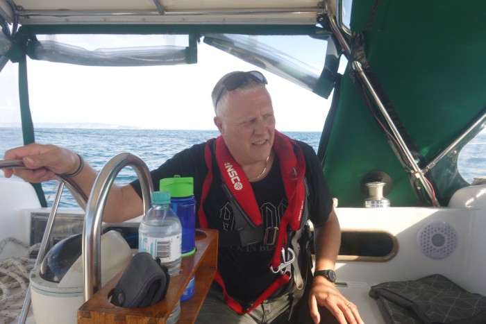
The conditions were good with only a light wind, low waves and swell of perhaps one metre. Still we kept religiously to the recommended track, only deviating slightly to let a yacht heading out pass by. As we entered the bar we could see the swell rise up and break on the sandbanks to either side of us. The sea also rose beneath us perhaps increasing the swell by 50%. After just over one nm we put in the required right angle turn to head south west and pushed on into the ‘mad mile’. This is where the tidal currents mix with the sea currents to cause disturbed water. The breakers were visible as a near solid line to port (seaward) with a patch or two to starboard. It was not too bad as we pitched and rolled a bit, but at least here we had depth, over 10m under the keel. A catamaran that had followed us over the bar overtook us. Catamarans have narrow hulls and so less stability fore and aft and we watched with interest as she pitched heavily, almost stopping in the troughs. Good old Tai Mo Shan just shrugged off the waves; no problem!
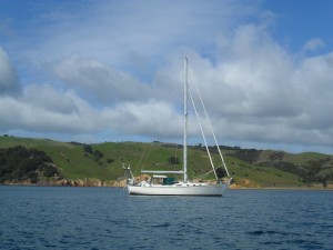
We were soon in the straits and past the dangers of the bar. We radioed Coastguard to thank them for their watch and motored on between the mainland (Inskip Point) and Fraser Island. Tin Can Bay was down an inlet to the south of us. The area is charted but shallow. Even at high tide we could see the water lapping on many sandbanks. The forecast was for northerly winds so we decided to pass the inlet and its shelter from southerly winds and instead anchor off Elbow Point, Fraser Island. This offered deep clear water on the edge of the channel and reasonable shelter. 1515 and we were anchored.
We put the dinghy in the water and Paul went ashore. This part of Fraser Island is bush, with (according to Google Earth) a track a few hundred metres inland. The shoreline is sand with mangroves fronting a marshy area. There had been a fire here with burnt patches on the trees. However, it was good to see almost all the trees showing a good amount of greenery and the bush floor covered in hard grasses; fire is part of the natural process in Australia. Paul saw what looked like dingo paw prints in the sand but, apart from the occasional bird and small fish no wildlife. The big teatree stick was not needed.
Photo: Going through the bar – ‘I’m not worried’.
Our plan was to sail up the coast, and then head to the West of Fraser Island, up the Great Sandy Strait. The strait would offer us shelter and anchorages from which to explore Fraser Island, a large sand island akin to Moreton and Stradbroke Islands. The only real navigational issue was that the straits southern entrance was guarded by the Wide Bay Bar. This bar is notorious and has claimed several craft and lives over the years. It is a comparatively long path through the bar, with swell from the south and east rising and breaking heavily on the sand banks. The gap through the bar is very mobile. As part of our passage planning Paul contacted the Tin Can Bay Coastguard who kindly provided up to date lat/long coordinates of the channel through the bar. Paul checked these with the latest survey carried out on 4th June 2020 provided in the latest Notice to Mariners issued by Maritime Safety Queensland. It is standard practice to time the entry through any bar to just before high tide. This provides an incoming tide to help damped down any breaking waves rolling in (entering on an ebb tide with an incoming swell or waves lead to the phenomenon of ‘wind against tide’ and higher, steeper seas – best avoided). Perhaps more importantly it provides us with the greatest water clearance under the keel.
As you can imagine, dropping off a wave so 16 ton of yacht lands on hard sand on its keel is really not great. So with some 110 nm to go to the bar we decided to sail up to Wide Bay, anchor off Double Island point and wait for a suitable time slot to cross the bay and the bar. Once over the bar we could easily find anchorage in the straits.
Our passage plan meant we could depart at mid morning, sail up the coast for 100 nm, taking 15 to 20 hours, and anchor in Wide Bay early morning. The forecast included a half moon rising quite late so we would have moonlight to anchor by.
Friday 12th June and we were up at 0700, breakfasted and boat prepared at 0830. We could then head to the marina buildings for a shower and goodbye to the marina office. Admin sorted we cast off at 0930 and headed to the fuel dock at the Moreton Bay Trailer Boat Club. The dock is quite tight but, with minimal wind, we are soon secure alongside and topping up our diesel (for the main engine) and petrol (for the outboard).
And so we were finally off. That forecast of a nice south easterly … well it was flat calm! We raised out main sail, more as a steadying sail than driving force, and motored on. A light southerly wind sprang up as we passed the islands near Manly but by then we were heading north at about 5 knots, so the 5 knot southerly meant we had zero apparent wind (i.e. the wind we felt on deck)! We pressed on, a favourable tide and clean hull meant we could keep the engine revolutions down to an economical 1750 and still maintain at least 5 knots over the ground as we went alongside the shipping channel. It was noticeable how little shipping there was. Normally we would see at least half a dozen ships transit the channel as we headed up Moreton Bay; that is why we plan to be alongside and not in the channel. This time we saw one ship enter Brisbane and one leave to anchor; none in the channel. We could only surmise this was an outcome of the global economic slowdown due to the Corona virus.
Dusk saw us at the northern entrance to Moreton Bay by Caloundra Heads. As we headed out into the Coral Sea a breeze sprang up from the South East. We had our Main sail and Yankee (foresail) set, and engine off, in double quick time; ah, sailing! As we turned to head north holding 2 to 4 nm off the coast the wind held and we made an easy 6 to 7 knots on a nice broad reach. We were the only boat on the water, and so with the boat trimmed, water hissing past, we could admire the (many) lights of the Sunshine Coast. Moolalaba was easily recognisable from the light on its headland and the high rise apartments. As the night wore on the wind moderated somewhat so our speed dropped to a reasonable 5 to 6 knots. Past Noosa the settlements thinned out and the land grew dark. Still as the moon rose we could make out the lighter coloured strip of sand forming that long beach.
The light on Double Island Point is visible from some 20 nm and so it’s flash provided an excellent navigation mark; it just takes nearly 4 hours to close! But close we did. We needed to turn off the wind and pass between the headland and Wolf Rock. Wolf Rock, lying a mile north of the point is on the chart, and described as an ‘awash’ rock. Unmarked, it lies just 0.4m below the surface at lowest astronomical tide and so presents quite a hazard. To be safe we dropped sails to the east of the point, turned downwind and motored into Wide Bay, holding about 1/4nm off the point.
Our target anchorage was in the south eastern corner of Wide Bay, hopefully gaining shelter from Double Island Point. The chart showed this as a fairly shallow area. However, our friends had explained that an occasional local phenomenon had occurred. The sands had shifted to form a sandbank a few hundred metres off the shore, which in turn formed a very sheltered lagoon behind. This lagoon was an excellent anchorage, but only for shallow draft vessels. It was too shallow for us to enter. The lagoon had formed; it is even visible on ‘Google Earth’. This meant the chart was inaccurate we had to be careful. As forecast the moon was up and, with only occasional clouds, we had good moonlight. However, the land and shoreline was still dark with only occasional lights inland. We motored on, eyes watching the depth sounder and probing the dark ahead. One light seemed closed than the others; it’s relative movement as we closed providing a vital clue. We drew closer and saw it was a sizeable yacht at anchor. We pressed on another 200 metres and then turned to the shore and dropped out anchor parallel to the other boat. 0400 and we were at anchor; 101 nm covered in some 17 ¾ hours.
Whilst Double Island Point offered shelter from the wind the swell just rolled around the point. As a result we had a ‘rolly’ night at anchor with quite a bit of motion. Still, we could sleep safely.
Saturday was a bright morning. We could see Wide Bay with its yellow sand cliffs leading to a beautiful sandy beach. And we could also see vehicles on the beach, dozens of them! The beach is a favourite for four wheel drivers. We could see the attraction of powering along a deserted beach, sand and spray flying, but this was more akin to Queen Street; it just needed traffic lights to complete!
High tide was forecast for the Wide Bay Bar for 1458. Ideally we wanted to enter the bar some 1½ hours before high tide. We were anchored about 8nm from the entry point, and so needed to depart at about 1200. 1155 saw us raising anchor and heading across the bay. There was a light south easterly allowing us to raise sails and use the engine to assist in holding a steady 5 knots. As we departed we called the coastguard on our radio. A problem; our call was distorted and difficult to read. We reverted to mobile phone and took the precaution of letting the coastguard know we would be crossing the bar; they would keep a watch. As we neared the entry point we dropped sails to allow us maximum manoeuvrability and called up coastguard. Our main radio was distorted, but our handheld VHF radio worked fine.
The conditions were good with only a light wind, low waves and swell of perhaps one metre. Still we kept religiously to the recommended track, only deviating slightly to let a yacht heading out pass by. As we entered the bar we could see the swell rise up and break on the sandbanks to either side of us. The sea also rose beneath us perhaps increasing the swell by 50%. After just over one nm we put in the required right angle turn to head south west and pushed on into the ‘mad mile’. This is where the tidal currents mix with the sea currents to cause disturbed water. The breakers were visible as a near solid line to port (seaward) with a patch or two to starboard. It was not too bad as we pitched and rolled a bit, but at least here we had depth, over 10m under the keel. A catamaran that had followed us over the bar overtook us. Catamarans have narrow hulls and so less stability fore and aft and we watched with interest as she pitched heavily, almost stopping in the troughs. Good old Tai Mo Shan just shrugged off the waves; no problem!
We were soon in the straits and past the dangers of the bar. We radioed Coastguard to thank them for their watch and motored on between the mainland (Inskip Point) and Fraser Island. Tin Can Bay was down an inlet to the south of us. The area is charted but shallow. Even at high tide we could see the water lapping on many sandbanks. The forecast was for northerly winds so we decided to pass the inlet and its shelter from southerly winds and instead anchor off Elbow Point, Fraser Island. This offered deep clear water on the edge of the channel and reasonable shelter. 1515 and we were anchored.
We put the dinghy in the water and Paul went ashore. This part of Fraser Island is bush, with (according to Google Earth) a track a few hundred metres inland. The shoreline is sand with mangroves fronting a marshy area. There had been a fire here with burnt patches on the trees. However, it was good to see almost all the trees showing a good amount of greenery and the bush floor covered in hard grasses; fire is part of the natural process in Australia. Paul saw what looked like dingo paw prints in the sand but, apart from the occasional bird and small fish no wildlife. The big teatree stick was not needed.
Photo: Going through the bar – ‘I’m not worried’.
Comments
| Vessel Name: | Tai Mo Shan |
| Vessel Make/Model: | North Cape 43 (Ed Brewer) |
| Hailing Port: | Auckland, NZ |
| Crew: | Paul and Helen Dickinson |
| About: | |
| Extra: | Tai Mo Shan was built in Hong Kong in 1980 by Emsworth Ltd of Athang Hau. Her name translates to 'Big Hat Mountain' which overlooks the boat yard. We prefer 'Tai Mo Shan'; something is lost in translation. Tai Mo Shan has a proud tradition of cruising the Pacific, and we intend to continue that. |
Gallery not available
Who: Paul and Helen Dickinson
Port: Auckland, NZ