
Tai Mo Shan
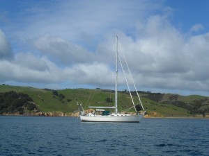
05 December 2022 | Tasman Sea
06 January 2021 | Moreton Bay, Australia
23 October 2020 | Brisbane, Australia
15 October 2020 | Gladstone, Australia
12 October 2020 | Mackay, Australia
07 October 2020 | Mackay, Australia
03 October 2020 | Townsville Australia
25 September 2020 | Magnetic Island, Australia
20 September 2020 | Hinchinbrook Island, Australia
12 September 2020 | Great Palm Island, Australia
12 September 2020 | Horseshoe Bay, Magnetic Island, Australia
06 September 2020 | Townsville, Australia
18 August 2020 | Townsville, Australia
12 August 2020 | Hook Reef, Australia
10 August 2020 | Hook Island, Australia
10 August 2020 | South Molle Island, Australia
06 August 2020 | Airlie Beach, Australia
06 August 2020 | Cid Harbour, Whitsunday Group, Australia
29 July 2020 | Shaw Island, Australia
29 July 2020 | Goldsmith Island, Australia
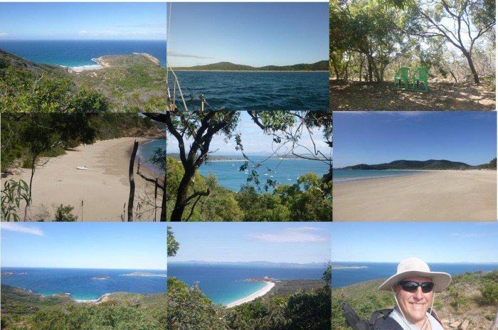
Great Keppel Island July 2020
09 July 2020 | Great Keppel Island, Australia
Paul Dickinson
We cast off from our berth at Gladstone Marina at the decidedly unsocial time of 0040. Our first obstacle was the dredge which was working in the lagoon. It was just off the end of our fairway so instead of heading straight out we had to detour around the hose, shown by a series of orange lit buoys, and through the ‘gate’ shown by a red buoy with a very orange-red light. Safely negotiated we headed out to the Gladstone Channel. There was practically no wind so it was a case of motoring with the Main sail as a steadying sail. Still we had a favourable tide giving us a welcome additional 2 knots of speed.
After a few miles, alongside the alumina plant, a light breeze set in and we were able to let out the Yankee and sail; very pleasant with the current. We soon got to the auxiliary channel alongside the shipping channel and so avoided the first bulk carrier coming into port. A little further and we reached where the channel cuts through shoaling mud banks before reaching the sea. We crossed the channel and remained to the north, just clear of the channel. The chart indicated that we should have at least 5m of water under the keel. No problem. Apart from the fact that when we looked we had, 3m, of water! OK, still safe but not as charted; a little concern. Then 2m, ugh, not as charted, shifting mud banks, shoaling on an ebb tide; tide to head back to the channel! It was only about 100m but, as the depth dropped to 1.8m, a little fraught. We were safe, but this was definitely not as charted. So back in the main channel we continued on. Another bulk carrier was coming in; we could clearly see her on the AIS, and then visually as she got closer. We called up on the VHF and the carrier asked us to vacate the channel. Fortunately the water was deeper here; indeed, as charted with some 9m under the keel. We passed without incident and were soon on the open sea heading north with a nice moderate south to south easterly breeze to push us along.
We rounded Great Keppel Island and dropped sails. Our cruising guide advised that motion due to the swell could be an issue, and that the swell was minimised by tucking into the north eastern corner off ‘Second Beach’ and Svendsen’s Beach. Our chart showed this is as shallow and sure enough, this was ‘Cat Corner’ as a dozen shallow draft catamarans were clustered in there. We needed more depth and so motored a little further to anchor in the shallow bay off Leeke’s Beach, close to 4 other monohull yachts. We were anchored at 1420.
Sitting some 8nm off the mainland, Great Keppel Island is approximately 3.5nm east to west and 2.5nm north to south. It is rocky with central hill some 174m high, and a ridge to the east with another peak some 169m high. It has a large drying lagoon in the middle, with some flat land, but is generally fairly steep, bush covered slopes. On the eastern side, the island has a resort and even an airstrip. The beaches around the island are white sand, and the clear shallow water reflects the sunlight off the sandy bottom. Leeke’s Beach where we anchored is an extensive beach about a mile long which shows some 50m of bright sand at low tide. This is backed by low bush hiding the drying lagoon. The land then rises up to the central hill and ridge, both covered with green bush, but with occasional red brown rocks and steep slope showing through.
At about 1600 a dingy came towards us. The occupant, Brian, invited us to sundowner drinks and nibbles on his yacht, ‘Zofia’, anchored nearby at 1630. And so as the sun dropped down we were on the ‘Zofia’ with Brian and his wife, Eva, as well as another couple Terry and his wife. All of us were experienced cruisers and we spent a few pleasant hours telling increasing tall sailing stories.
Tuesday and Paul decided to walk up the central hill; a circular route of perhaps some 6km, but with that 174m climb. Helen did not feel up to it and so elected to remain aboard Tai Mo Shan and take in the view from there. Our cruising guide had a map of the island showing the walking tracks. We did not want to take the guide ashore, so Paul traced the diagram. The makeshift map went into rucksack along with the other bushwalking essentials of drinks, nut bars, spare shirt, first aid kit, insect repellent, machete and mobile phone (in a sealed plastic bag). Trusty tea tree ‘stick’ in hand Paul headed ashore. He soon found the path leading from the beach; no signs just a gap in the bush well-marked by footprints and what looked like quad tracks. The path was sand, stone and rock and was easy to follow, if a little steep in places. The bush was open and pleasant, quite dry with that spicy bush aroma. There were a series of viewpoints along the way and the views were magnificent as the hill and its approach ridges rose above the island and surrounding sea. The return was through the flat inner land adjacent to the lagoon. A surprise here as the bush suddenly gave way to a paddock with hardy grass and … a herd of goats! A little further was ‘The Homestead’ a small locked building that had seen better days; not least as its supporting piles were at a slight angle. A little further and Paul was back on the beach. A small tikki tour followed as he headed along the beach to the eastern corner where a small creek exited from the lagoon. There was just enough water for the dinghy to pass over the shallow entrance. Heading in, some of the flat brown rocks moved; these were small rays some 30 to 50cm across startled by the dinghy. The creek soon deepened but only extended a short way inland. Another surprise … a small yacht was in the mangroves supported by poles dry at low tide. Well, it certainly was a secure location if only accessible at high tide.
Wednesday was not the best day; cloudy with a threat of rain, strong winds and a swell leading to some motion in the boat. Even though we were securely anchored we remained aboard.
Thursday and Paul wanted to walk the remaining ridge and peaks to the light at Bald Rock Point at the south east corner of the island. This would be a 12km walk with some steep slopes. Helen declined to join him. As before the path was easy to find and follow. And as before at times it got pretty steep and rocky. This time though the viewpoints had nice little stone markers. Even better, at intervals there were plastic seats set down. One could rest and enjoy the superb views! The last part leading to the light was interesting. The wind, still blowing some 20 to 25 knots was largely cancelled by the bush, so most of the walk was effectively in a gentle breeze. However, the last part of perhaps 500m or so was along a rocky ridge some 75m above sea level. The wind simply roared across the sea and rose up and over the ridge blasting everything in its path. Only a few low level scrubby bushes and grasses could survive with most of the land bare rock and stones. And, yes, a few wild goats! The light at the end was a small affair, a steel cylinder some 3m high on a concrete base with solar panels and a small (30 cm diameter) light. A bit further inland was a small concrete helipad pad perhaps 5m square. The wind was insistent so it was time for a quick drink and then head back. Great Keppel Island was clearly quite arid. It was noticeable that there were far fewer spiders than on Fraser Island; indeed, we saw none. There was still a fair selection of birdlife visible; crows, kookaburras, swiftlets and magpies, and even a peacock! A treat was hearing a rustling in the grass and then seeing an echidna. It was doing the old ‘you can’t see me if I can’t see you’ burrowing its head in to the grass tussock, so only the mass of black and yellow spines was visible.
The swell had increased with the wind so Thursday night was quite unpleasant with a significant rolling motion. Still we could get the rugby on the TV so all was not lost. The wind was forecast to drop on Friday. In fact, the weather in general was due to moderate so we decided to take advantage and head off to the Percy Group of islands.
Comments
| Vessel Name: | Tai Mo Shan |
| Vessel Make/Model: | North Cape 43 (Ed Brewer) |
| Hailing Port: | Auckland, NZ |
| Crew: | Paul and Helen Dickinson |
| About: | |
| Extra: | Tai Mo Shan was built in Hong Kong in 1980 by Emsworth Ltd of Athang Hau. Her name translates to 'Big Hat Mountain' which overlooks the boat yard. We prefer 'Tai Mo Shan'; something is lost in translation. Tai Mo Shan has a proud tradition of cruising the Pacific, and we intend to continue that. |
Gallery not available
Who: Paul and Helen Dickinson
Port: Auckland, NZ