
Tai Mo Shan
05 December 2022 | Tasman Sea
06 January 2021 | Moreton Bay, Australia
23 October 2020 | Brisbane, Australia
15 October 2020 | Gladstone, Australia
12 October 2020 | Mackay, Australia
07 October 2020 | Mackay, Australia
03 October 2020 | Townsville Australia
25 September 2020 | Magnetic Island, Australia
20 September 2020 | Hinchinbrook Island, Australia
12 September 2020 | Great Palm Island, Australia
12 September 2020 | Horseshoe Bay, Magnetic Island, Australia
06 September 2020 | Townsville, Australia
18 August 2020 | Townsville, Australia
12 August 2020 | Hook Reef, Australia
10 August 2020 | Hook Island, Australia
10 August 2020 | South Molle Island, Australia
06 August 2020 | Airlie Beach, Australia
06 August 2020 | Cid Harbour, Whitsunday Group, Australia
29 July 2020 | Shaw Island, Australia
29 July 2020 | Goldsmith Island, Australia
The Percy Group July 2020
14 July 2020 | Percy Islands, Australia
Paul Dickinson
Our Alan Lucas cruising guide had warned that our anchorage at Great Keppel Island gave good protection to the south easterly trade winds but was prone to swell that rolled around the north east corner and hit anchored boats side on. We had noticed some movement during our stay. However, by Thursday 9 Jul the swell had increased significantly driven by the constant trade winds. And did we roll that night! The larger sets hit every few minutes and Tai Mo Shan rolled as much as ± 15 degrees. That is uncomfortable. So we were definitely moving on the next day. However, we had a problem in that our next anchorage would be Rocky Shelf Bay on South Percy Island. This bay gave good protection from the wind and reasonable from the swell. However, it did have a, to quote the cruising guide, ‘difficult to define fringing reef of rock and coral’. This was accompanied by the warning not to over-run the reef when anchoring. We therefore needed to arrive at the anchorage in day light, and preferably also at low tide (so the reef would be more visible). The passage was about 100nm which, given our usual passage planning speed of 5 knots, meant about 20 hours sailing. We had to modify this speed as we would be sailing downwind, so would sail faster; 6 knots meant just under 17 hours passage. If we left at 1300 we would arrive between 0600 and 0900.
The rolling at Great Keppel Island was unpleasant so, unable to stand any more, we weighed anchor at 1250. The forecast was for a south east wind of 15 to 20 knots swinging easterly and dropping to 10 to 15 knots later. As we left we caught that nice breeze as a bream reach and were soon slicing through the water at 6 to 7 knots, and occasionally more. Normally this is great but in this case it was too fast! We reefed sails and got our speed down to between 5 and 6 knots.
Night fell with the usual beautiful multi-coloured sunset. The moon did not rise until about 2300 so we then had a few hours of darkness. Holding off the largely deserted coast it was dark, very dark. There were no lights visible ashore, and very few navigation lights. Our instruments seemed to be very bright even when on the lowest possible illumination. The world outside was indistinct, and we almost seemed to be floating in space were it not for the wonderful, beautifully defined stars shining like diamonds in the inky blackness.
Our boat computer provided the chart plotter and showed that we were safely on course. At about 2000 a pop up appeared informing us that the computer would restart to install updates. We were on a safe heading for a couple of hours and so this would not be a problem, so yes, go ahead and install. Ah, a minor thing, only minor, this was a big update so might take some minutes. And off it went, blank screen. And the cockpit repeat of the GPS data is fed from the AIS through the computer, so that also disappeared. And it stayed blank for a long time! After an hour or so the lack of navigational data got slightly disconcerting. We still had the compass and water log (for boat speed), and easily maintained heading. But still, we were used to knowing where we were at all times. Our standby chartplotter still worked well, but that was inside by the nav station. Ah well, time to test the standby standby; the laptop. And, after a few minutes configuring, that … worked perfectly. An hour or so later (yes, our boat computer is getting on a bit) the updates were completed and all back to normal. No problem!
The wind dropped early morning allowing us to slow the boat and so reduce our average speed. By daybreak we could clearly see South Percy Island. We rounded the north west corner at about 0830 and headed to the anchoring spot. Low tide had been at 0751, so we were just after the tide, in daylight. And we were rewarded by being able to make out the shallower reef water; it did indeed extend a way offshore, perhaps 200m or more. With the reef defined, we anchored safely clear of the reef with some 12m of water under the keel at 0910.
South Percy is the southern-most island of the Percy Group. Shaped a bit like a frying pan with the handle heading north east for just under 2 nm. The ‘pan’ is about 2.5 nm by 2nm. The long northern bay contained our anchorage and provides shelter from easterly through southerly to westerly winds. Apparently a strong swell can roll around the ends of the island but fortunately the swell had eased overnight as the wind dropped. The island is a national park and uninhabited. As seems the norm for these islands, the shore line was bright white sand, leading to moderately slopes rising up several tens of metres and covered in bush. Dry stream beds cut into the slopes with denser vegetation at the base. We could see no signs of human activity; no buildings or structures, no track or paths, no clearing or cultivation. In fact when we went ashore we could only see a couple of what might have been human footprints but had been eroded over time.
After lunch we took the dinghy ashore. The clear water made the rocky shelf quite visible. It seemed to rise up quite steeply (and so presented a hazard as the rapid change in depth would give limited warning) and consisted of rocks, sand and occasional coral heads. Though shallow we could easily pass over in the dinghy to the sandy shoreline. We explored the beach and into a dry stream bed. The bush rising up the slopes did not have any paths and so would have been hard going. As noted above, there were minimal signs of humans. Surprisingly there were no seabirds; crows, swiftlets, waders, even butterflies yes; but no terns or gulls. The rocky outcrops contained a few rock pools but these were only sparsely occupied. And to Helen’s disappointment, the beach was almost completely devoid of shells. It was a strange feeling, empty island, and Tai Mo Shan anchored more than 300m offshore; lonely.
The weather and sea were calm and we had a great barbeque aboard Tai Mo Shan that night, enjoying the outlook and isolation.
We decided we had explored South Percy Island sufficiently and so the next day, Sunday, we weighed anchor on a glass calm sea and motored the 8nm to the next island, the appropriately named Middle Percy Island. For the record the other islands are the smaller and almost impossible to anchor at North East Island, and the equally difficult to anchor at islet South East Island.
Middle Percy Island is approximately rectangular some 3nm North West to South East by 2.5nm South West to North East. Our cruising guide advised that West Bay is seldom swell free but is in a lovely setting. The bottom is sand and the beach clear of fringing reef. Great. Unfortunately our charts did not have much detail on the bay, apart from showing it as shallow. Confusingly our Navionics chart showed the red polka dots of shallow (less than 2m) water with a spot depth of 2.9m. Ah well. The tides around here were still significant (over 3m) and with potentially shallow water, Paul created his ‘tide’ ladder of tide heights to time; just to be sure.
We rounded the bluff leading to West Bay and, relief (!), saw a couple of yachts anchored in the bay. Still cautious we slowly headed into the bay, and had plenty of water beneath us. We anchored without drama.
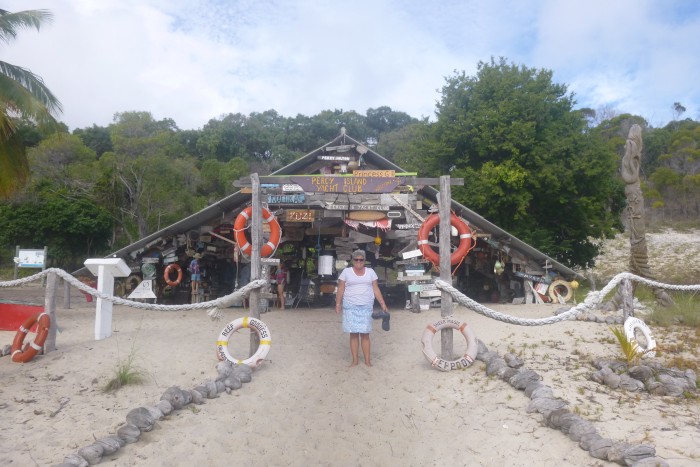
West Bay is a delight. The wide sandy beach leads to bush covered slopes; the colours in the sun were divine; turquoise water, white sand, green bush, blue sky … There were other boats anchored in the bay and ashore, buildings and some small tents. We were soon walking up the beach to the large A frame building. This was the ‘Percy Island Yacht Club’. It had some facilities such as a tap, hammock and fire pit, but was most striking for the yachting memorabilia. Over the years passing yachts had left items with their name on them. These varied from simple pieces of wood with the boat and crew names painted on to masterpieces of carving, painting and ingenuity. There was even an old binnacle with names etched on. There were literally hundreds of mementos, and we spent some time just looking at and reading them. As if this was not enough, the beach also sported an old tin shack. This was the old telephone station, long disused. However, inside was filled with the older boat mementos. These were simpler affairs; typically just names painted on, or burned into, wood. But these were the originals. The oldest we could find was 1962, with the newest in the 80’s; the A frame had the newer ones. What an unexpected historical treasure trove!
The beach also had noticeboards with the general history of the island (it had been leased to families over time, and now the leasee was also the island warden), the usual biosecurity info, and a map showing the island and some walks. Of note, the long walk to the ‘Homestead’ and the short walk (or goat track) back. A little further was a private shack, and just along the vehicle track a foldable noticeboard informing that the Homestead would not be taking visitors on Monday (i.e. the next day). We walked on a short way keen to see the lagoon. This lagoon, with a narrow approach from the sea, dries out. We had seen at least one catamaran in the lagoon sitting high and dry. The island history also noted that one family had built a boat at the Homestead, disassembled it and carried it down to the lagoon before reassembling it and heading out to sea. More surprises, the short walk to the lagoon showed that the lagoon had 5 or 6 boats in it, including a large monohull ketch being worked on, as well as a boat shed, equipment, materials and even a couple of quad bikes.
We returned to Tai Mo Shan. It was now mid-afternoon and Paul was keen to walk to the Homestead whilst it was still possible. Helen was not keen on the 6½ km round trip and so remained aboard whilst Paul returned ashore, put on boots and rucksack and set off; long way up, short way down.
The long track was a sandy vehicle track winding up through bush and wood to the Homestead at the central height of the island. There were a couple of viewpoints offering wonderful views on the way. One viewpoint had a couple of sundials; slightly random. At the other a rustling in the bush betrayed a couple of wallabies who stood, looked, and then bounded off. Most fascinating were the butterflies. At various locations the trees were full of them. As Paul approached they would take to the air and flutter about, the rustling of wings loud in the otherwise quiet bush. It was quite an experience to be suddenly closely surrounded by literally hundreds of flying insects.
The Homestead is approached by crossing a field of goats. It is a two storey large house with a garden fence and some outbuildings. A hundred metres to the front is a small grave commemorating the Armitage family and Leslie Brake who were lost at sea between Mackay and Percy in 1938 as well as Henry White who died in 1944 aged 73 having lived on the island for 23 years. As Paul passed he noticed a man working intently on a Ute; Paul did not disturb him but walked on. There were more farm type buildings and outhouses in various states of disrepair and array; this had been a working farm in the past but now looked past its prime.
The vehicle track continued to the outbuildings. However, a wooden sign pointed to the ‘Short Route’ to the beach; a path off the main track. Paul took it. This was a narrow walking path. Rustling in the bush betrayed goats this time. The track started down, and got much steeper. The footprints in the sandy soil showed that this was indeed a goat track that humans occasionally used. Onwards, downwards, steep, and then a more gentle slope. This track was shorter than the long track and soon led to the lagoon, and then onto the beach.
Back on board Tai Mo Shan and Helen caught a fish! Using a plastic lure she hauled in a reasonable sized (40cm) white and yellow fish with a powerful mouth and white teeth. We did not recognise the fish and so Paul headed off to a neighbouring boat where a couple of fishermen were enjoying a beer. A quick chat and they could not really identify the fish. They suspected it was a ‘bone crusher’, a coral eating fish. We are wary of coral eating fish due to the toxin released by the coral algae that can lead to the serious condition Ciguatera, so the fish went back.
The forecast for the Monday was south easterly 10 to 15 knots. We were therefore more than a little surprised to wake and find a south westerly blowing straight into West Bay. Almost as we looked the wind increased and the sea became extremely rough with a short sharp chop causing Tai Mo Shan to pitch quite violently. Only a couple of boats were left in the bay; most of the other boats had left. We quickly stowed the barbeque and then got the motor off the dinghy and the dinghy up on the davits. This was quite a task as the stern was pitching some 1.5 metres! We were underway at 0805.
The strong wind on a beam reach gave us full power. With full Main and a reef in the Yankee we were overpowered and uncomfortable, with speeds often reaching 9 knots plus. A reef in the Main settled things allowing us a much more comfortable ride whilst still making 7 to 8 knots. By lunchtime we had overhauled and passed 2 of the yachts that had left earlier.
Another point of interest was seeing several whales. Fortunately these were still a mile or so away as the large black bodies erupted from the sea to fall back with immense splashes. These were easily visible despite the multiple ‘white horses’. Later we would pass large patches of ‘whale snot’ or whale poo. This shows as an orange brown oily scum on the sea surface. The brighter the colour, the more recent the deposit. At one point we passed multiple patches lasting for perhaps 500m, some of it very bright. This must have been caused recently be a large pod. We kept a good look out, ready to start the engine to make noise in the sea (which would hopefully keep the creatures away from us). We breathed a sigh of relief when we did not spot any more whales.
Lunchtime saw us pass the Beverly Group of islands. They provided some shelter from the wind and waves, allowing things to calm down somewhat. Then, about mid-afternoon the wind started to moderate and swing southerly. We passed Prudhoe island with a 15 knot southerly blowing, forcing us to shake out the reefs, and then ‘pole and prevent’ on a run to maintain progress at about 6 knots. Ahead we could see the ships anchored waiting to load coal from the immense wharf complex at Dalrymple Bay; over a dozen of them. And further north another three ships waiting to enter the harbour at Mackay. All the ships showed on AIS making plotting a safe path easy.
Mid-afternoon we were able to gain mobile phone reception and so contact Mackay Marina. They were able to give us a berth, B36, and emailed a map of the marina.
Early evening and the wind dropped still further. From blasting along reefed we were now motor sailing!
Night fell as we approached Mackay harbour. The outer harbour is used for commercial shipping, whilst the marina is in the inner harbour. About one mile out we called up Mackay VTS on the VHF radio and got permission to transit the outer harbour. It was, again, dark with no moon. The outer harbour did have navigation lights, including leading lights. However, it also had very, very many other lights, and several of these were much much brighter than the navigation lights. Furthermore, the tides at Mackay are quite large, and the associated currents quite strong. It was a fraught couple of minutes passing between the large rock breakwaters into the outer harbour. And then onto the inner harbour; this did not have any navigation lights at the entrance; just keep the rock breakwaters 20m off the port side. Into the marina, and it was dark! Helen used a torch to illuminate the end of the piers allowing us to pass as a safe distance. The emailed map proved its use and soon Helen was illuminating the right berth. Just as quickly we were in and secure.
Our comment to the marina office; this is a really dark marina!
Picture: Helen at the Percy Island Yacht Club.
The rolling at Great Keppel Island was unpleasant so, unable to stand any more, we weighed anchor at 1250. The forecast was for a south east wind of 15 to 20 knots swinging easterly and dropping to 10 to 15 knots later. As we left we caught that nice breeze as a bream reach and were soon slicing through the water at 6 to 7 knots, and occasionally more. Normally this is great but in this case it was too fast! We reefed sails and got our speed down to between 5 and 6 knots.
Night fell with the usual beautiful multi-coloured sunset. The moon did not rise until about 2300 so we then had a few hours of darkness. Holding off the largely deserted coast it was dark, very dark. There were no lights visible ashore, and very few navigation lights. Our instruments seemed to be very bright even when on the lowest possible illumination. The world outside was indistinct, and we almost seemed to be floating in space were it not for the wonderful, beautifully defined stars shining like diamonds in the inky blackness.
Our boat computer provided the chart plotter and showed that we were safely on course. At about 2000 a pop up appeared informing us that the computer would restart to install updates. We were on a safe heading for a couple of hours and so this would not be a problem, so yes, go ahead and install. Ah, a minor thing, only minor, this was a big update so might take some minutes. And off it went, blank screen. And the cockpit repeat of the GPS data is fed from the AIS through the computer, so that also disappeared. And it stayed blank for a long time! After an hour or so the lack of navigational data got slightly disconcerting. We still had the compass and water log (for boat speed), and easily maintained heading. But still, we were used to knowing where we were at all times. Our standby chartplotter still worked well, but that was inside by the nav station. Ah well, time to test the standby standby; the laptop. And, after a few minutes configuring, that … worked perfectly. An hour or so later (yes, our boat computer is getting on a bit) the updates were completed and all back to normal. No problem!
The wind dropped early morning allowing us to slow the boat and so reduce our average speed. By daybreak we could clearly see South Percy Island. We rounded the north west corner at about 0830 and headed to the anchoring spot. Low tide had been at 0751, so we were just after the tide, in daylight. And we were rewarded by being able to make out the shallower reef water; it did indeed extend a way offshore, perhaps 200m or more. With the reef defined, we anchored safely clear of the reef with some 12m of water under the keel at 0910.
South Percy is the southern-most island of the Percy Group. Shaped a bit like a frying pan with the handle heading north east for just under 2 nm. The ‘pan’ is about 2.5 nm by 2nm. The long northern bay contained our anchorage and provides shelter from easterly through southerly to westerly winds. Apparently a strong swell can roll around the ends of the island but fortunately the swell had eased overnight as the wind dropped. The island is a national park and uninhabited. As seems the norm for these islands, the shore line was bright white sand, leading to moderately slopes rising up several tens of metres and covered in bush. Dry stream beds cut into the slopes with denser vegetation at the base. We could see no signs of human activity; no buildings or structures, no track or paths, no clearing or cultivation. In fact when we went ashore we could only see a couple of what might have been human footprints but had been eroded over time.
After lunch we took the dinghy ashore. The clear water made the rocky shelf quite visible. It seemed to rise up quite steeply (and so presented a hazard as the rapid change in depth would give limited warning) and consisted of rocks, sand and occasional coral heads. Though shallow we could easily pass over in the dinghy to the sandy shoreline. We explored the beach and into a dry stream bed. The bush rising up the slopes did not have any paths and so would have been hard going. As noted above, there were minimal signs of humans. Surprisingly there were no seabirds; crows, swiftlets, waders, even butterflies yes; but no terns or gulls. The rocky outcrops contained a few rock pools but these were only sparsely occupied. And to Helen’s disappointment, the beach was almost completely devoid of shells. It was a strange feeling, empty island, and Tai Mo Shan anchored more than 300m offshore; lonely.
The weather and sea were calm and we had a great barbeque aboard Tai Mo Shan that night, enjoying the outlook and isolation.
We decided we had explored South Percy Island sufficiently and so the next day, Sunday, we weighed anchor on a glass calm sea and motored the 8nm to the next island, the appropriately named Middle Percy Island. For the record the other islands are the smaller and almost impossible to anchor at North East Island, and the equally difficult to anchor at islet South East Island.
Middle Percy Island is approximately rectangular some 3nm North West to South East by 2.5nm South West to North East. Our cruising guide advised that West Bay is seldom swell free but is in a lovely setting. The bottom is sand and the beach clear of fringing reef. Great. Unfortunately our charts did not have much detail on the bay, apart from showing it as shallow. Confusingly our Navionics chart showed the red polka dots of shallow (less than 2m) water with a spot depth of 2.9m. Ah well. The tides around here were still significant (over 3m) and with potentially shallow water, Paul created his ‘tide’ ladder of tide heights to time; just to be sure.
We rounded the bluff leading to West Bay and, relief (!), saw a couple of yachts anchored in the bay. Still cautious we slowly headed into the bay, and had plenty of water beneath us. We anchored without drama.
West Bay is a delight. The wide sandy beach leads to bush covered slopes; the colours in the sun were divine; turquoise water, white sand, green bush, blue sky … There were other boats anchored in the bay and ashore, buildings and some small tents. We were soon walking up the beach to the large A frame building. This was the ‘Percy Island Yacht Club’. It had some facilities such as a tap, hammock and fire pit, but was most striking for the yachting memorabilia. Over the years passing yachts had left items with their name on them. These varied from simple pieces of wood with the boat and crew names painted on to masterpieces of carving, painting and ingenuity. There was even an old binnacle with names etched on. There were literally hundreds of mementos, and we spent some time just looking at and reading them. As if this was not enough, the beach also sported an old tin shack. This was the old telephone station, long disused. However, inside was filled with the older boat mementos. These were simpler affairs; typically just names painted on, or burned into, wood. But these were the originals. The oldest we could find was 1962, with the newest in the 80’s; the A frame had the newer ones. What an unexpected historical treasure trove!
The beach also had noticeboards with the general history of the island (it had been leased to families over time, and now the leasee was also the island warden), the usual biosecurity info, and a map showing the island and some walks. Of note, the long walk to the ‘Homestead’ and the short walk (or goat track) back. A little further was a private shack, and just along the vehicle track a foldable noticeboard informing that the Homestead would not be taking visitors on Monday (i.e. the next day). We walked on a short way keen to see the lagoon. This lagoon, with a narrow approach from the sea, dries out. We had seen at least one catamaran in the lagoon sitting high and dry. The island history also noted that one family had built a boat at the Homestead, disassembled it and carried it down to the lagoon before reassembling it and heading out to sea. More surprises, the short walk to the lagoon showed that the lagoon had 5 or 6 boats in it, including a large monohull ketch being worked on, as well as a boat shed, equipment, materials and even a couple of quad bikes.
We returned to Tai Mo Shan. It was now mid-afternoon and Paul was keen to walk to the Homestead whilst it was still possible. Helen was not keen on the 6½ km round trip and so remained aboard whilst Paul returned ashore, put on boots and rucksack and set off; long way up, short way down.
The long track was a sandy vehicle track winding up through bush and wood to the Homestead at the central height of the island. There were a couple of viewpoints offering wonderful views on the way. One viewpoint had a couple of sundials; slightly random. At the other a rustling in the bush betrayed a couple of wallabies who stood, looked, and then bounded off. Most fascinating were the butterflies. At various locations the trees were full of them. As Paul approached they would take to the air and flutter about, the rustling of wings loud in the otherwise quiet bush. It was quite an experience to be suddenly closely surrounded by literally hundreds of flying insects.
The Homestead is approached by crossing a field of goats. It is a two storey large house with a garden fence and some outbuildings. A hundred metres to the front is a small grave commemorating the Armitage family and Leslie Brake who were lost at sea between Mackay and Percy in 1938 as well as Henry White who died in 1944 aged 73 having lived on the island for 23 years. As Paul passed he noticed a man working intently on a Ute; Paul did not disturb him but walked on. There were more farm type buildings and outhouses in various states of disrepair and array; this had been a working farm in the past but now looked past its prime.
The vehicle track continued to the outbuildings. However, a wooden sign pointed to the ‘Short Route’ to the beach; a path off the main track. Paul took it. This was a narrow walking path. Rustling in the bush betrayed goats this time. The track started down, and got much steeper. The footprints in the sandy soil showed that this was indeed a goat track that humans occasionally used. Onwards, downwards, steep, and then a more gentle slope. This track was shorter than the long track and soon led to the lagoon, and then onto the beach.
Back on board Tai Mo Shan and Helen caught a fish! Using a plastic lure she hauled in a reasonable sized (40cm) white and yellow fish with a powerful mouth and white teeth. We did not recognise the fish and so Paul headed off to a neighbouring boat where a couple of fishermen were enjoying a beer. A quick chat and they could not really identify the fish. They suspected it was a ‘bone crusher’, a coral eating fish. We are wary of coral eating fish due to the toxin released by the coral algae that can lead to the serious condition Ciguatera, so the fish went back.
The forecast for the Monday was south easterly 10 to 15 knots. We were therefore more than a little surprised to wake and find a south westerly blowing straight into West Bay. Almost as we looked the wind increased and the sea became extremely rough with a short sharp chop causing Tai Mo Shan to pitch quite violently. Only a couple of boats were left in the bay; most of the other boats had left. We quickly stowed the barbeque and then got the motor off the dinghy and the dinghy up on the davits. This was quite a task as the stern was pitching some 1.5 metres! We were underway at 0805.
The strong wind on a beam reach gave us full power. With full Main and a reef in the Yankee we were overpowered and uncomfortable, with speeds often reaching 9 knots plus. A reef in the Main settled things allowing us a much more comfortable ride whilst still making 7 to 8 knots. By lunchtime we had overhauled and passed 2 of the yachts that had left earlier.
Another point of interest was seeing several whales. Fortunately these were still a mile or so away as the large black bodies erupted from the sea to fall back with immense splashes. These were easily visible despite the multiple ‘white horses’. Later we would pass large patches of ‘whale snot’ or whale poo. This shows as an orange brown oily scum on the sea surface. The brighter the colour, the more recent the deposit. At one point we passed multiple patches lasting for perhaps 500m, some of it very bright. This must have been caused recently be a large pod. We kept a good look out, ready to start the engine to make noise in the sea (which would hopefully keep the creatures away from us). We breathed a sigh of relief when we did not spot any more whales.
Lunchtime saw us pass the Beverly Group of islands. They provided some shelter from the wind and waves, allowing things to calm down somewhat. Then, about mid-afternoon the wind started to moderate and swing southerly. We passed Prudhoe island with a 15 knot southerly blowing, forcing us to shake out the reefs, and then ‘pole and prevent’ on a run to maintain progress at about 6 knots. Ahead we could see the ships anchored waiting to load coal from the immense wharf complex at Dalrymple Bay; over a dozen of them. And further north another three ships waiting to enter the harbour at Mackay. All the ships showed on AIS making plotting a safe path easy.
Mid-afternoon we were able to gain mobile phone reception and so contact Mackay Marina. They were able to give us a berth, B36, and emailed a map of the marina.
Early evening and the wind dropped still further. From blasting along reefed we were now motor sailing!
Night fell as we approached Mackay harbour. The outer harbour is used for commercial shipping, whilst the marina is in the inner harbour. About one mile out we called up Mackay VTS on the VHF radio and got permission to transit the outer harbour. It was, again, dark with no moon. The outer harbour did have navigation lights, including leading lights. However, it also had very, very many other lights, and several of these were much much brighter than the navigation lights. Furthermore, the tides at Mackay are quite large, and the associated currents quite strong. It was a fraught couple of minutes passing between the large rock breakwaters into the outer harbour. And then onto the inner harbour; this did not have any navigation lights at the entrance; just keep the rock breakwaters 20m off the port side. Into the marina, and it was dark! Helen used a torch to illuminate the end of the piers allowing us to pass as a safe distance. The emailed map proved its use and soon Helen was illuminating the right berth. Just as quickly we were in and secure.
Our comment to the marina office; this is a really dark marina!
Picture: Helen at the Percy Island Yacht Club.
Comments
| Vessel Name: | Tai Mo Shan |
| Vessel Make/Model: | North Cape 43 (Ed Brewer) |
| Hailing Port: | Auckland, NZ |
| Crew: | Paul and Helen Dickinson |
| About: | |
| Extra: | Tai Mo Shan was built in Hong Kong in 1980 by Emsworth Ltd of Athang Hau. Her name translates to 'Big Hat Mountain' which overlooks the boat yard. We prefer 'Tai Mo Shan'; something is lost in translation. Tai Mo Shan has a proud tradition of cruising the Pacific, and we intend to continue that. |
Gallery not available
Who: Paul and Helen Dickinson
Port: Auckland, NZ