
Tai Mo Shan
05 December 2022 | Tasman Sea
06 January 2021 | Moreton Bay, Australia
23 October 2020 | Brisbane, Australia
15 October 2020 | Gladstone, Australia
12 October 2020 | Mackay, Australia
07 October 2020 | Mackay, Australia
03 October 2020 | Townsville Australia
25 September 2020 | Magnetic Island, Australia
20 September 2020 | Hinchinbrook Island, Australia
12 September 2020 | Great Palm Island, Australia
12 September 2020 | Horseshoe Bay, Magnetic Island, Australia
06 September 2020 | Townsville, Australia
18 August 2020 | Townsville, Australia
12 August 2020 | Hook Reef, Australia
10 August 2020 | Hook Island, Australia
10 August 2020 | South Molle Island, Australia
06 August 2020 | Airlie Beach, Australia
06 August 2020 | Cid Harbour, Whitsunday Group, Australia
29 July 2020 | Shaw Island, Australia
29 July 2020 | Goldsmith Island, Australia
Cid Harbour July 2020
06 August 2020 | Cid Harbour, Whitsunday Group, Australia
Paul Dickinson
Tuesday 28 July and after breakfast we weighed anchor just off Shaw Island at 0910. The forecast was for a light south to south west wind with sunny weather. And the forecast looked to be mostly right as the morning was nicely sunny, albeit with a moderate southerly wind.
We were soon clear of the anchorage and raised sails. We then had a nice broad reach for some 9 nm past Lindeman Island and into the channel between the islands close to the mainland (Long Island and Pine Island) and the westernmost island of the Whitsunday Group, Dent Island. Even with the moderate wind we still made an easy 7 knots. We noticed one of the large cruising catamarans had raised anchor some 10 minutes after us and was now following us. Now we were cruising and so not racing, of course not. But then, the definition of a yacht race is two boats going in the same direction! The catamaran should have been faster off the wind and so we watched carefully, as he steadily dropped behind us – oh, yes!
As we entered the passage between Pine Island and Dent Island the wind swung behind us. We altered our sail plan to the usual ‘pole and prevent’ and continued downwind on a run. The tide was now flowing and we noticed we had about one knot of current against us. Dent Island is long and thin (about 2.8nm north to south, by 0.6 east to west). Our cruising guide noted that it housed the golf course for Hamilton Island. As we cruised past we looked carefully, and could just about, perhaps see one of two of the greens. We clearly see the small lighthouse halfway up its steep rocky slopes. There appeared to be no land access to the cluster of buildings around the lighthouse, only a lift on rails ascending from the sea. The shore was rocky and we surmised that it would be quite a task to get ashore in calm weather, and very difficult in any kind of sea. And to complete the picture a whale gently broached about 400m away from us; the huge body taking several seconds to rise up and disappear again after the blow.
5nm or so later and we rounded Loriad Point of Whitsunday Island to go through the gap separating Cid Island. The wind was blanked by the headland and the tidal current raced through the gap. Our autopilot started to struggle so it was a case of hand steering to hold Tai Mo Shan on course. A mile later and we were into the calm waters of Cid Harbour. This was a large shallow bay protected to from the north through east and south to southwest by the bulk of Whitsunday Island, and further protected to the west by Cid Island. The shoreline was rocky bluffs separating a few sandy beaches. The land behind was the (now usual) steep bush covered slopes. This was a popular anchorage and already had more than a dozen boats at anchor. Fortunately it is also extensive and could readily house perhaps five to ten times that number. We looked for our friend’s (Brian and Gillian) boat, Maxedout, and soon spotted its unsupported mast. Maxedout is unusual in having a self-supporting mast. This makes the boat simpler as there are no shrouds at the side supporting the mast but, of course, means the mast must be stronger. The concept, from the 70s and 80s, did not really catch on.
We dropped sails and motored to perhaps some 150m away from Maxed Out. On our way in we noticed small white triangular buoys. These are normally placed by the Park authority to mark out reef protection areas. These areas contain coral reefs and anchoring is prohibited. However, we were in a popular anchorage. As we passed the buoys seemed to have a no swimming sign on them. We were focused on finding an anchoring spot and so had no time to investigate further. A few minutes later, at 1240, we were anchored some 400m off the rocky bluff near Sawmill Bay.
We had the dinghy in the water after lunch. First, those buoys. We headed to the nearest. It did indeed have a no swimming sign, along with the warning that sharks inhabited Cid Harbour. OK, no swimming then.
Next we headed to Sawmill Bay. En route we saw that our friend’s dinghy was not at their boat. We went ashore and saw our friend’s dinghy being moved up the beach. The couple moving the dinghy informed us that our friends were walking the track to the peak, and had been concerned about their dingy drifting off as the tide was coming in and the walk was taking some time. We noted that we carried long lengths of line and had tied our dinghy to a tree at the top of the beach.
We explored Sawmill Bay with Helen doing her usual beachcombing. There was a park picnic area with tables and seating. In addition, a large noticeboard told of two paths. One, headed to Whitsunday Peak, some 460m high, was labelled difficult. Another went to an adjacent bay, Turtle Bay. We returned to our dinghy and decided to ‘tikki tour’ the coast. Well, it was easier than walking to Turtle Bay!
On our return we noticed that the tide had risen further and was very close to our friend’s dinghy. We returned to the beach and pulled the dinghy up further, securing the painter to a rock.
Later our friends called on us. The path was good, but steep and so the walk had been taxing and they were sore and exhausted. We would catch up with then the next day.
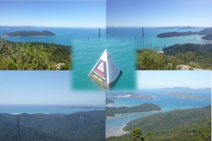
Wednesday and yes, Paul just had to do the summit walk. Helen, perhaps with more sense, decided to remain on Tai Mo Shan. So mid-morning Paul was ashore, backpack on, boots on, stick in hand. The walk through the bush was on a good, well defined, if somewhat uneven and rocky path. However, it was also all uphill. Rock steps helped, but still uphill and then more uphill. An hour later and Paul reached the peak. The lookout was on a bare rock area, with superb views to the north and west over Cid Harbour and across to the mainland. The sun was shining and the colours in the water simply beautiful clearly showing the varying depth of water. It also showed that the tide had receded and Sawmill Bay beach was now dry some way out; the dinghy would need to be dragged a distance. The only downside was that the boats at anchor were obscured by a smaller bush covered ridge. And to make it better, there was a path to another lookout. Again, this was a bare rock area with superb views to the south and east. If anything the colours in the water were more pronounced as this view included the shallower waters near Hamilton Island. It was somehow fitting that there was not a manmade structure at the peak as the views really showed Whitsunday Island in all its glory; well worth the climb. And another COVID bonus, Paul had only passed one pair of walkers on the way up. The peak and its views were all his!
The walk down was, well a bit easier, if quite hard on the knees. The path was almost deserted, only two couples on the way up. Of interest as the path skirted and crossed a stream it was possible to make out the straight lines of the remains of the dam used by the loggers to hold the water to help with their milling process (apparently they used a steam powered mill).
Back on the beach and fortunately one end of the beach (where the dinghy was) was quite steep so the long pull to the sea was avoided.
Paul passed Maxedout and sundowners on Tai Mo Shan was soon arranged. That evening was a good social evening, good friends, good wine and good chat.
Thursday was a general chill out day as we remained aboard Tai Mo Shan and drank in the scenery. However our supplies were running low and we needed to restock. Our Internet enquiries showed that Hamilton Island, some 10nm away, had a marina and local grocery store. But Hamilton Island Marina charged about $100 a night! Airlie Beach was some 15nm away. That had full facilities including a couple of supermarkets. One marina, Coral Sea, was almost as expensive as Hamilton Island. The other, Port Airlie, was still expensive at $80 a night. Hmm. The alternative was to sail some 45nm to the settlement of Bowen. This had a very small marina, with pile moorings and a very few berths. OK, we decided on Port Airlie. An email confirmed that they had a berth available, just call when close by. So Port Airlie it would be on Friday.
Picture: Views from Whitsunday Peak – top to the north and west, bottom to the south and east. Just don’t swim in the water!
We were soon clear of the anchorage and raised sails. We then had a nice broad reach for some 9 nm past Lindeman Island and into the channel between the islands close to the mainland (Long Island and Pine Island) and the westernmost island of the Whitsunday Group, Dent Island. Even with the moderate wind we still made an easy 7 knots. We noticed one of the large cruising catamarans had raised anchor some 10 minutes after us and was now following us. Now we were cruising and so not racing, of course not. But then, the definition of a yacht race is two boats going in the same direction! The catamaran should have been faster off the wind and so we watched carefully, as he steadily dropped behind us – oh, yes!
As we entered the passage between Pine Island and Dent Island the wind swung behind us. We altered our sail plan to the usual ‘pole and prevent’ and continued downwind on a run. The tide was now flowing and we noticed we had about one knot of current against us. Dent Island is long and thin (about 2.8nm north to south, by 0.6 east to west). Our cruising guide noted that it housed the golf course for Hamilton Island. As we cruised past we looked carefully, and could just about, perhaps see one of two of the greens. We clearly see the small lighthouse halfway up its steep rocky slopes. There appeared to be no land access to the cluster of buildings around the lighthouse, only a lift on rails ascending from the sea. The shore was rocky and we surmised that it would be quite a task to get ashore in calm weather, and very difficult in any kind of sea. And to complete the picture a whale gently broached about 400m away from us; the huge body taking several seconds to rise up and disappear again after the blow.
5nm or so later and we rounded Loriad Point of Whitsunday Island to go through the gap separating Cid Island. The wind was blanked by the headland and the tidal current raced through the gap. Our autopilot started to struggle so it was a case of hand steering to hold Tai Mo Shan on course. A mile later and we were into the calm waters of Cid Harbour. This was a large shallow bay protected to from the north through east and south to southwest by the bulk of Whitsunday Island, and further protected to the west by Cid Island. The shoreline was rocky bluffs separating a few sandy beaches. The land behind was the (now usual) steep bush covered slopes. This was a popular anchorage and already had more than a dozen boats at anchor. Fortunately it is also extensive and could readily house perhaps five to ten times that number. We looked for our friend’s (Brian and Gillian) boat, Maxedout, and soon spotted its unsupported mast. Maxedout is unusual in having a self-supporting mast. This makes the boat simpler as there are no shrouds at the side supporting the mast but, of course, means the mast must be stronger. The concept, from the 70s and 80s, did not really catch on.
We dropped sails and motored to perhaps some 150m away from Maxed Out. On our way in we noticed small white triangular buoys. These are normally placed by the Park authority to mark out reef protection areas. These areas contain coral reefs and anchoring is prohibited. However, we were in a popular anchorage. As we passed the buoys seemed to have a no swimming sign on them. We were focused on finding an anchoring spot and so had no time to investigate further. A few minutes later, at 1240, we were anchored some 400m off the rocky bluff near Sawmill Bay.
We had the dinghy in the water after lunch. First, those buoys. We headed to the nearest. It did indeed have a no swimming sign, along with the warning that sharks inhabited Cid Harbour. OK, no swimming then.
Next we headed to Sawmill Bay. En route we saw that our friend’s dinghy was not at their boat. We went ashore and saw our friend’s dinghy being moved up the beach. The couple moving the dinghy informed us that our friends were walking the track to the peak, and had been concerned about their dingy drifting off as the tide was coming in and the walk was taking some time. We noted that we carried long lengths of line and had tied our dinghy to a tree at the top of the beach.
We explored Sawmill Bay with Helen doing her usual beachcombing. There was a park picnic area with tables and seating. In addition, a large noticeboard told of two paths. One, headed to Whitsunday Peak, some 460m high, was labelled difficult. Another went to an adjacent bay, Turtle Bay. We returned to our dinghy and decided to ‘tikki tour’ the coast. Well, it was easier than walking to Turtle Bay!
On our return we noticed that the tide had risen further and was very close to our friend’s dinghy. We returned to the beach and pulled the dinghy up further, securing the painter to a rock.
Later our friends called on us. The path was good, but steep and so the walk had been taxing and they were sore and exhausted. We would catch up with then the next day.
Wednesday and yes, Paul just had to do the summit walk. Helen, perhaps with more sense, decided to remain on Tai Mo Shan. So mid-morning Paul was ashore, backpack on, boots on, stick in hand. The walk through the bush was on a good, well defined, if somewhat uneven and rocky path. However, it was also all uphill. Rock steps helped, but still uphill and then more uphill. An hour later and Paul reached the peak. The lookout was on a bare rock area, with superb views to the north and west over Cid Harbour and across to the mainland. The sun was shining and the colours in the water simply beautiful clearly showing the varying depth of water. It also showed that the tide had receded and Sawmill Bay beach was now dry some way out; the dinghy would need to be dragged a distance. The only downside was that the boats at anchor were obscured by a smaller bush covered ridge. And to make it better, there was a path to another lookout. Again, this was a bare rock area with superb views to the south and east. If anything the colours in the water were more pronounced as this view included the shallower waters near Hamilton Island. It was somehow fitting that there was not a manmade structure at the peak as the views really showed Whitsunday Island in all its glory; well worth the climb. And another COVID bonus, Paul had only passed one pair of walkers on the way up. The peak and its views were all his!
The walk down was, well a bit easier, if quite hard on the knees. The path was almost deserted, only two couples on the way up. Of interest as the path skirted and crossed a stream it was possible to make out the straight lines of the remains of the dam used by the loggers to hold the water to help with their milling process (apparently they used a steam powered mill).
Back on the beach and fortunately one end of the beach (where the dinghy was) was quite steep so the long pull to the sea was avoided.
Paul passed Maxedout and sundowners on Tai Mo Shan was soon arranged. That evening was a good social evening, good friends, good wine and good chat.
Thursday was a general chill out day as we remained aboard Tai Mo Shan and drank in the scenery. However our supplies were running low and we needed to restock. Our Internet enquiries showed that Hamilton Island, some 10nm away, had a marina and local grocery store. But Hamilton Island Marina charged about $100 a night! Airlie Beach was some 15nm away. That had full facilities including a couple of supermarkets. One marina, Coral Sea, was almost as expensive as Hamilton Island. The other, Port Airlie, was still expensive at $80 a night. Hmm. The alternative was to sail some 45nm to the settlement of Bowen. This had a very small marina, with pile moorings and a very few berths. OK, we decided on Port Airlie. An email confirmed that they had a berth available, just call when close by. So Port Airlie it would be on Friday.
Picture: Views from Whitsunday Peak – top to the north and west, bottom to the south and east. Just don’t swim in the water!
Comments
| Vessel Name: | Tai Mo Shan |
| Vessel Make/Model: | North Cape 43 (Ed Brewer) |
| Hailing Port: | Auckland, NZ |
| Crew: | Paul and Helen Dickinson |
| About: | |
| Extra: | Tai Mo Shan was built in Hong Kong in 1980 by Emsworth Ltd of Athang Hau. Her name translates to 'Big Hat Mountain' which overlooks the boat yard. We prefer 'Tai Mo Shan'; something is lost in translation. Tai Mo Shan has a proud tradition of cruising the Pacific, and we intend to continue that. |
Gallery not available
Who: Paul and Helen Dickinson
Port: Auckland, NZ