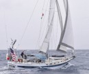
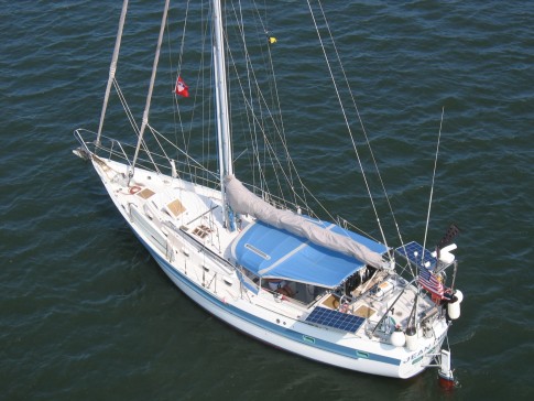
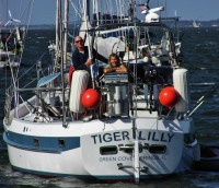
S/V Tiger Lilly
Rig heavy, reef early, and pray often; for God does not assure us an easy passage, but He does promise a safe anchorage...

25 May 2018 | TRINCOMALEE, SRI LANKA
02 January 2018 | Clan Jeti Anchorage, Georgetown, Penang Island, Malaysia
03 November 2016 | Singapore, Southeast Asia
02 October 2016 | Kumai River, Borneo
24 August 2016 | Rindja Island, Indonesia
22 July 2016 | Fannie Bay, Darwin, Northern Territory, Australia
14 June 2016 | Pancake Creek, Queensland, Australia
13 June 2016 | Pancake Creek, Queensland, Australia
11 June 2016 | Burnette Heads, Queensland, Australia
07 June 2016 | Mooloolaba, Queensland, Australia
11 May 2016 | Colmsie, Brisbane River, Queensland, Australia
23 December 2015 | Brisbane, Australia
13 August 2015 | Whangarei, New Zealand
07 August 2015 | Whangarei, New Zealand
23 July 2015 | Whangarei, New Zealand
12 April 2015 | Whangarei, New Zealand
11 February 2015 | Whangarei, New Zealand
25 January 2015 | Whangarei, New Zealand
24 September 2014 | BORA BORA, French Polynesia
23 September 2014 | Bora Bora
TIGER LILLY'S AMAZON DELTA CRUISE - PART 3
18 October 2013 | BREVES TO AFUA - THE BACK WATERS
Tom and Lilly
THE AMAZON DELTA BACK WATERS
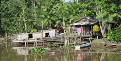
The Rio Amazon, as its very name suggests, is the largest river in the world. For many years the lure of the jungles and rainforests of the equatorial Delta Region intrigued us; we had seen videos of its wonders and were captivated by the possibility of sailing Tiger Lilly to this exciting destination. The Amazon drains the central part of the continent of tropical South America - one of the wettest regions of the world. Added to the Amazon's huge volume of outflow are coastal tides ranging from 10 to 20 feet, ebbing and flooding twice each day - and the influence of these powerful tides are felt hundreds of miles into the heart of Amazonia. It is difficult to gain an understanding of just how much water flows through the region. Lying in our bunk at night we hear the current ripping by Tiger Lilly's hull at speeds exceeding three knots; putting a considerable strain on Big Bruce our best bower anchor. Anything or anyone who goes over the side in these conditions would disappear into the darkness, never to be found. The Amazon Delta covers an area of some 25,000 square miles of tropical rainforest and jungle penetrated by a maze of many thousands of miles of rivers, bays, straights, natural canals, and creeks. The region is dominated by the large island of Ilha De Marajo which is bordered on the north by the Rio Amazon, on the south by the Rio Para, on the east by the South Atlantic Ocean, and on the west by a network of capillary waterways connecting the Rio Amazon to the Rio Para. This Blog is about navigating 300 miles on the western side of Ilha De Marajo, from the Rio Para to the Rio Amazon - from Belem to Afua.
Tiger Lilly's 550 mile two month cruise through the Amazon Delta has described a "U" tipped over towards the northeast. It is about 100 miles up the broad Rio Para from the sea buoy southwest to Belem, the capital of the Brazilian state of Para, and a city of some 1.5 million people. Continuing up the Rio Para another 150 miles brought us to the frontier town of Breves. Tiger Lilly turned north at Breves and headed for the town of Afua on the Rio Amazon; we motored 150 miles through a circuitous network of picturesque tropical rivers, walled in by dense rainforest, and dotted with the simple homes of hardy back-country people. The bustling little town of Afua is our last stop before we put the dinghy on deck and head back to sea. We will have another 150 miles to work our way out the mouth of the Rio Amazon against the easterly Trade Winds, back across the Equator into the Northern Hemisphere, and out the Canal Norte to the Rio Amazon sea buoy. The Canal Norte has a reputation for being quite rough; we can only make progress to the northeast when the 17 foot tide is on the ebb - flowing against the easterly Trades and producing a very choppy river. When the tide is on the flood - up to 5 knots against us - we will anchor and wait for it to turn. Our cruise around the periphery of the Delta's Ilha De Marajo was mostly under power. Although the interior of the region is gently brushed by the easterly Trade Winds, sailing is seldom an option in the muddy back waters of the Amazon Delta - the high tropical forest easily tops our mast. Tiger Lilly holds 160 gallons of diesel fuel, and accessibility to fuel here is not a problem with fuel docks in Soure, Belem, Breves, and Afua. What is needed for this cruise is a good reliable auxiliary diesel; we very much depended on Mister Perkins - and thus far he has not let us down.
Without a complete portfolio of Brazilian Navy large-scale paper charts of the region it is not readily apparent just how one goes about navigating the back side of Ilha De Marajo between Breves and Afua. Our C-MAP NT+ electronic charts (which cost $200USD per chip, and cover half of the east coast of South America) only chart the deep-water commercial channels in the Rio Amazon and the Rio Para. It was our NAVIONICS electronic charts (South America complete, and the entire Caribbean up to Florida, $54USD) installed on our iPad2 which showed us the way from Breves to Afua. However, most of the time we navigate the rivers by just keeping Tiger Lilly between the trees, and watching the fathometer. If our iPad2 quits we will just have to send Lilly to the nearest cabin to ask the Indians how to get out of here. We had multiple local Brazilian sources warn us about steering clear of the bandits on the RIO JABURU and ILHA DO JABURU - the most direct route between Breves and Afua. Using the NAVIONICS charts we were able to plot a safe course around that troubled area via ESTREITO DE BREVES (aka RIO PARAUAU), FURO DOS MACACOS, RIO ARAMA, FURO DO GIPURU , FURO ACARA PEREIRA, RIO CAJWINA, the CANAL SANTANA, and finally the CANAL DE AFUA - we came in the back door to Afua, just like the locals do! Tiger Lilly is an ocean-going sailing yacht, and she draws nearly 7 feet; but we never had a problem finding deep water, with average depths in these fast-running tidal rivers to be 40 to 50 feet - and often 80 to 100 feet. With such an interwoven maze of waterways, influenced by the Rio Para's 6 foot tides to the south and the Rio Amazon's 17 foot tides to the north, it was usually a puzzle to figure out when to depart our anchorage in order to catch a favorable tidal current to help us along our way north. Sometimes, we would pass a junction with another river and see a reversal in the current, and our speed would go from 6.5 knots to 2.9 knots in a couple boat lengths.
Lilly sez: OH MY GOSH! He makes such a big thing about something so simple. Ladies, it is just a matter of GRAVITY - water will ALWAYS flow down-hill. When I owned a carpet cleaning company - in a previous lifetime, when I actually KNEW something - I would always have to explain to housewives why their closets were wet after the toilet overflowed on the other side of the house. On the particular day that we had this discussion, we had been anchored on a small cano and a HUGE log, longer than Tiger Lilly, passed the boat and headed for the main river. The day before when we entered that same cano, the water was flowing rapidly south across the mouth, and there was just NO WAY that this morning that that log was going to be able to turn the corner and go north - it is just so obvious. You would think that Mister Naval Engineer could see such a simple thing. Yet his best thinking resulted in our getting under-way and bucking the current in the main river for most of the morning. You also would think that someone who sits in the head for hours every day reading all those fat complicated navigation books of his could apply a little common sense now and again.
Tom reasonably and quietly replies: Folks, uncharacteristically, these tidal current discussions (a complex subject for trained mariners to be sure) were one of the very few times that I just bit my friggin tongue and kept steering the flippin boat.
(Lilly interjects: REASONABLY? QUIETLY? FRIGGIN? FLIPPIN? HUH!)
Tom continues: Imagine, all those years studying navigation, reduced to such a simple statement of certitude - and of course the real kick in the teeth was that her "Gravity Observation Method of Determining Multiple Source Tidal Currents" (NOT to be found ANYWHERE in Bowditch's "American Practical Navigator") was more-often-than-not correct. WHODA THUNK! Do you suppose that as the gravity of the moon skews the surface of the world's oceans it actually distorts a Venetian's thought process the same way? These people can be SO difficult to understand; and if you cannot understand how someone thinks, how can they be effectively trained or lead? OK Boot Camp - when do YOU think we should get under-way tomorrow?
Lilly sez: Maybe I'll tell you then, if you are nice.
Located in the Brazilian state of Para, the Amazon Delta is sparsely, but evenly populated along the rivers; as we cruised the western side of Ilha De Marajo we seldom went more than a half-mile without passing a small home on the water. There are very few roads in the area, and most communication between communities is by riverboat. In our two months cruise in the Delta, we only saw waterborne law enforcement or military presence (pretty much the same thing in Brazil) at the big city of Belem. A foreign cruising boat in this region has a difficult challenge on hand when it comes to safety and security. Communications is a big part of security, and very few people speak or understand English; unless you speak Portuguese, the radio (VHF or HF) is of little use. Our experience cruising in remote areas has taught us that security is all about defense, and a passive defense built on information at that - we need to simply stay away from trouble. Going to General Quarters against Bad Guys armed with big guns, small morals, and little to lose is not an option for a Mom and Pop couple out exploring the world. We are pleased to report that after cruising the Amazon Delta's waterways over a period of two months we did not have even a hint of a security problem. The Brazilian people we met were noticeably concerned about our safety, and on more than one occasion took their time and effort to proactively ensure that we were safe.
Lilly sez: Bruce Willis, and his entertaining movies, have convinced an entire generation of Baby Boomers that they too can be tough guys - but it just ain't so. The Amazon Delta is not the Back Lot at Twentieth Century Fox, and there are no stand-in doubles or stunt men aboard Tiger Lilly for the hard parts. Staying safe out here is not a matter of signing up for Cross Fit and hitting the pistol range with your trusty Glock once a month. This is serious business, with real consequences. We pay very close attention to the safety of our environment, and we take the time to connect with local people - perhaps our best safety resource. But at the end of the day it is the Lord, and His promise in Psalm 91 that is our anchor to windward. Check it out - He is there for us all.
The art and science of river navigation differs markedly from navigating a vessel at sea. An enjoyable way to learn about river navigation, and have a good laugh along the way, is to read Mark Twain's "Life on the Mississippi." We navigated Tiger Lilly in the Amazon Delta in many ways similar to the way the steam boat pilots of the Nineteenth Century ran the Mississippi River. The vessel is moved across the breadth of the river based on the principle that deep fast water is in the bends, and slower shallower water is on the points as the river meanders through the countryside. When running against the current we get up on the bank and run right along the shore in slack water - or if you are lucky, a favorable back eddy off the main current. In bends we stay up on the point - as far as the water depth allows. Between the bends, in the straight reaches, we cross to the opposite bank to get set up for the next turn. When running down-stream, we take her into the deeper water of the bends to get the most favorable boost from the current; and in the reaches we run down the center of the river. In the Amazon Delta the tropical forest creates a high green wall right along the banks, and in fact, larger trees often overhang the banks. When running close to the shore we have to watch for tree limbs above as well as shoals below. When we accidentally hit an overhanging limb with the cap shroud Lilly patrols the deck picking up small branches and stomping on the bugs that rain down with the leaves and twigs. Once the tide turns, if our speed falls below 3 knots we generally anchor, take a nap, and wait for more favorable conditions - just like the local boatmen.
CRUISING NOTES:
Here are the anchorages we used on our route from Belem to Afua:
1-28.6S 048-28.6W RIO GUAMA - Moored between the buoys at Marina B and B. We departed Marina B and B just as the tide started to rise so that we would have rising water to navigate the shallow CANAL CARNAPIJO. In the RIO GUAJARA-ACU we were being set down on the shoal at 1-29.5S 048-31.2W by the strong flood, and we had to use engine power and adjust our course north of west to clear the shoal to the west. We stayed towards the eastern shore of ILAS DAS ONCAS, and rounded the south end of that island and stood into the south end of the CANAL CARNAPIJO - the area of our greatest concern regarding water depth. Between the south end of ILHA DOS ONCAS and the entrance to FURO DO ARROZAL, we found deeper water to the west while we were south of the entrance to RIO CAJEZAL, and to the east to the north of RIO CAJEZEL - we were glad to have the rising tide in our favor, but the depths appeared to be sufficient to transit this area at any stage of the tide.
1-28.2S 048-40.8W FURO DO ARROZAL - There was plenty of mast clearance under the un-charted high tension electric wires spanning the waterway. We would have been better off to have anchored another mile further east as the incoming tide and the wind played havoc with our anchorage. (Lilly sez: I TOLD him when we anchored that we should be further back from the entrance - but what would I know?)
1-39.2S 049-21.9W CANAL NORTE on the RIO PARA south of ILHA DO SANTAREM - Out on the broad RIO PARA we had to dodge some fishing net activity - watch for their marker flags on the up-current end of the net, and the fishing boat hanging off the down-current end. As soon as we spot a fishing boat with her nose in the current, we start looking for the hard-to-see net buoys. The government safe-navigation buoy's south east of ILHA JOROCA and BANCO JOROCA are not on station as charted. We went north of the island towards PONTA NEGRA, following the tug and barge traffic. We tried to anchor on the south side of the canal on the north shore of ILHA DO CANDIRU, but the anchor would not bite - apparently the heavy current had the bottom scoured-out to hard pan. As it worked out, we were much better off, as the heavy commercial traffic that runs all night runs close along the north shore of ILHA DO CANDIRU. Sometimes luck puts us in the right place.
1-45.7S 049-56.9W East of ILHA DO SAMANAJOS - This was our only anchorage not in proximity to a home. We tried to anchor by inhabited houses for security reasons, and because Lilly likes to socialize with the families along the river, but it just did not work out on this particular leg of our voyage up the RIO PARA. As we motored up the ESTREITO DE BREVES, Lilly was handing out the Captain's favorite hard candy to the local kids in passing canoes. We wish we would have stocked-up on more things to give the kids (candy, balloons, paper and pens), as we were around plenty of youngsters all the way to Afua.
1-41.7S 050-28.7W Town of Breves - We landed the dinghy at the research station dock. They had 24-7 security on the dock, a gate guard at the front entrance, and they warmly welcomed us. The firemen's dock (Bombeiros) is just to the southeast. Waterfront security is good here, but this side of town is a little rough for after-dark walking. Diesel fuel at Breves cost 2.69 Real per liter (2.4 Real = One USD in October 2013). A local math teacher, Osiel Lima Ferreira, very kindly took us under his wing and gave us a great tour of Breves - his hometown. Osiel is also a licensed river boat operator, and he gave us good first-hand information regarding security on the rivers, and a scenic and safe way to get to Afua in the north. Lilly sez: Oh Tom-Tom my favorite part of Breves, well actually not just Breves but all of the Delta Region, are the wonderful school children of ALL ages and how they followed us to just hear English being spoken. That young high school girl Christine, who kept hugging me and telling me that she had learned English in school (and she certainly has done an excellent job), has NEVER heard it spoken with a real person in conversation - only with her teacher in the classroom. She and all the 30 other kids that gathered around us at the high school were so excited; all of them just wanted a picture for Face Book with the American visitors, and to hear them talk. What a delightful time we had with the children in Breves. Thank you Osiel! I believe that God put all the right people right in our path once again.
1-31.2S 050-33.7W FURO DOS MACACOS - We had a busy day taking on fuel at the Shell Fuel Dock, saying good bye to new-found friends, and departing Breves on a favorable tide, so this was just a short hop to get started north. Multiple sources in Breves (subsequently confirmed by local folks along the river) told us to steer clear of the bandits on the FURO JABURU. (We did not make that name up - but wish we had, Central Casting could not have done better in naming the bandits who infest this direct route between Breves and Afua.) After heading north on the ESTREITO DE BREVES we took a detour around the junction with the FURO JABURU by turning east into the RIO TAUAU, RIO TEJUTEUA, RIO PARIRIJO, and then heading back north in the FURO DOS MACACOS. By making this 10 mile loop out to the east and back, Tiger Lilly was not visible from the mouth of the RIO JABURU - a prudent measure that did not take much additional time, but increased our safety factor. There is a government school at this anchorage called E.M.E.F Santo Antonio, and Lilly had lots of fun with the school kids giving them rowing lessons in our hard dinghy Grace. It baffles these expert young dugout canoe paddlers that this white woman faces aft while rowing forward! She overcomes much of the language problem (we understand very little Portuguese, and they do not speak English) by taking our iPad2 ashore and sharing pictures of our travels and our family with the local ladies. Tom has been to all of these places with Lilly, speaks the same language she does (well, kind of), and is absolutely amazed (and confused) at some of the "facts" this woman presents to her eager audience - were we actually on the same boat, on the same planet? (Or did she forget her glasses again, cannot see the pictures on the iPad screen, and is just making up a story?) Based on their enthusiastic response, local people always seem to be the MOST interested in pictures we have taken of them, their river, and their neighbors. With lots of hand waving, sign language, and diagrams in the pocket note book we always carry, communications seem to work out just fine. Tom-Tom never ceases to be amazed after overhearing some spirited exchange between Lilly and one of the local ladies, and then she confidently informs him that: "Her new friend is 32 years-old, has 7 children (two boys and five girls - but the girls are married and live in Belem), goes to the grocery store once a week with her husband in the family boat, uses Crest toothpaste, shares a Face Book page with her sister who lives three miles down the river (Lilly now has her email address written in her pocket notebook), and she has a urinary infection - treatable by extract of the acai berry." All Tom-Tom wants to know is what time do they think the tide will turn tomorrow morning?
1-20.4S 050-22.9W FURO DOS MACACOS - This was a staging anchorage to position Tiger Lilly to make a jump by the north coast of the ILHA DO JABURU on the next move.
0-49.0S 050-23.7W FURO DO GIPURU - This was a long day, as we pushed to get well clear of Bandit Country and north of the ILHA DO JABURU. After we anchored, Lilly rowed ashore at dusk and met the family in the house we were anchored by. They told her it was quite safe here on this section of FURO DO GIPURU. Lilly spent quite some time visiting and laughing with the ladies, and then she went out into the night with one of their husbands and set a fishing net to catch supper. She impressed the fellow when he started to bail the canoe by kicking his foot up the smooth interior of the boat, and she followed suit. Apparently, the only white women he had seen were pictures of movie stars and magazine models. The fact that La Tigre Lillian would go fishing, and know how to bail a canoe native style impressed this Brazilian outback man to no end. She came back to Tiger Lilly with two fish, a bowl of farinha, and a bowl of acai for our (her) dinner. (Tom had familiar American pasta with Lilly's tomato and garlic sauce for dinner - thank you very much.) The farina is a wheat meal which Brazilians mix with just about everything; it adds bulk to most foods. The acai is a dark purple bitter paste which they make from the acai palm fruit which grows everywhere in the region. Acai is the principle ingredient of Mona Vie, the purple berry juice which the network marketers sell for $40 per bottle. Almost all the money goes to the pyramid scheme (and the pretty bottle) as the ubiquitous acai berry is very cheap in the Amazon Delta! Most every home in the region has a pile of the acai berries stacked outside. It just goes to show that P.T. Barnum was correct - there is a sucker born every minute; and there will always be a P.T. Barnum character around to sell him an over-priced product he doesn't need.
0-18.4S 050-23.0W - A small cano off the RIO CAJWINA. This was a rather nice side trip and a worthwhile place to spend some time. We anchored off a small home occupied by a young newly married couple and their baby. Typically, her parents lived a few hundred yards down the cano, and she was connected to her family by a path on the river bank. When the local folks first see Tiger Lilly they are very shy, and then surprised when they see Lilly rowing their way in Grace. Then they are all smiles, and laughter, and many questions for their strange new gringa visitor. Even the poorest people of the Amazon Delta seem to have iPhone type cell phones, and the young people love to take pictures with them - just like in the USA. Probably three quarters of the simple little homes that dotted the river banks of the Delta Region have large dish satellite antennas for their TV's. Bill Gates not only changed American culture - he has changed the world with his technology.
0-09.5S 050-23.6W CANAL DE AFUA - We are posting this blog at the town of Afua, known as the "Venice of Marajo" as it is built on platforms elevated some six feet above the surface of a muddy bog. The town is clean, and neat, and very vibrant with the houses painted and trimmed with bright colors. There are several docks on the waterfront and finding a place to land the dinghy is not a problem; but we do have to keep an eye on Grace in the 11 foot tides - she is always finding her way under a dock on a rising tide, or stranding on a mud bank as the water recedes. There is a Banco De Brazil here with ATM machines which accept our USA VISA debit card. The Beira Rio fuel dock (2.75 Real / liter) is east of the church, around the corner in the RIO MARAJOZINHO - but you will need the tide to get alongside. They sell cooking gas (butane) at the fuel dock. There are plenty of shops of all types here, and re-provisioning is convenient. There is an Internet access shop one block in from the waterfront, turn left and walk to the end of the walkway (about four blocks), turn right, and it is on the left. The charge for Internet access is 3 Real per hour - quite reasonable. The town is safe, and easy to get around. There are no motor vehicles, but there are bicycles of every shape and size everywhere. Afua is a colorful and exciting little town - in an exotic place; but some things just don't change. We just had a knock on the hull, and it was a young professional looking well dressed Brazilian couple speaking English - welcoming us to Afua, and distributing Jehovah's Witness literature!
It wasn't easy getting down here, and it will not be easy getting back out to the sea - perhaps that is why so few boats chose to cruise the Amazon Delta. However, cruising this fascinating region has been most rewarding and satisfying. In 26 years, and 60,000 miles of cruising Tiger Lilly, we have seldom felt more at home, or more cared for, in a foreign land - the Brazilian people are extraordinarily warm-hearted. The flora, the fauna, and the people of the Amazon Delta will go down in Tiger Lilly's Deck Log, and our hearts and memories, as world class.
To see Tiger Lilly's photos of the Amazon Delta, click on the PHOTO GALLERY link at the top-right of this page and follow the logic tree as follows: Main / Ports of Call / South America / Brazil / Amazon Delta - see you there!
Comments
| Vessel Name: | Tiger Lilly |
| Vessel Make/Model: | 1977 CSY44 walkover hull #55 |
| Hailing Port: | Green Cove Springs |
| Crew: | Lilly and Tom Service |
| About: | |
| Extra: | |
| Social: |
|
Tiger Lilly's Photos - Main
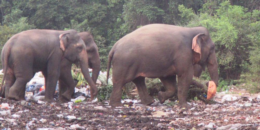 |
Approximately 100 Asian elephants live in and around the Trincomalee Landfill in northeast Sri Lanka. These huge creatures eat plastic strewn trash and garbage because they have been driven back from their natural habitat by the encroachment of farms.
38 Photos
Created 24 September 2018
|
 |
.JPG) |
.JPG) |
 |
 |
 |
 |
 |
 |
 |
S/V Tiger Lilly
Who: Lilly and Tom Service
Port: Green Cove Springs
Gallery