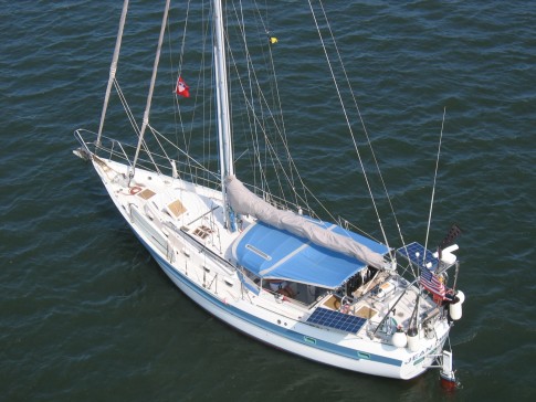
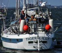
S/V Tiger Lilly
Rig heavy, reef early, and pray often; for God does not assure us an easy passage, but He does promise a safe anchorage...

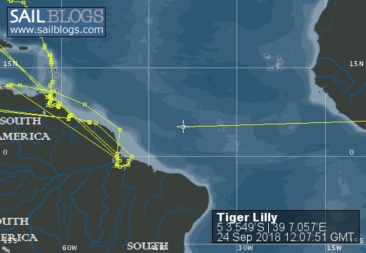
25 May 2018 | TRINCOMALEE, SRI LANKA
02 January 2018 | Clan Jeti Anchorage, Georgetown, Penang Island, Malaysia
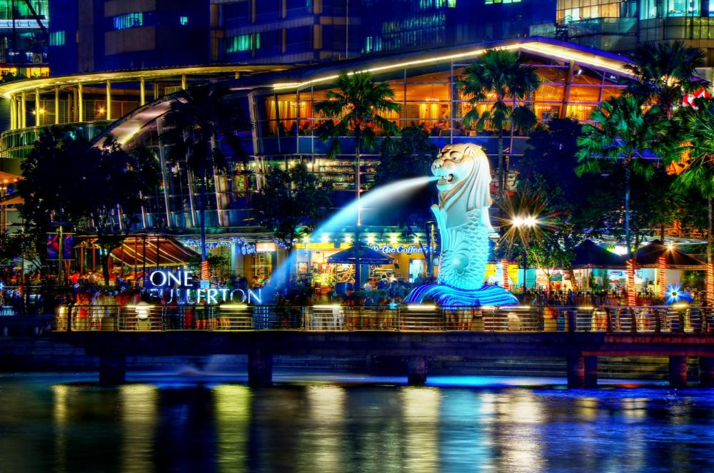
03 November 2016 | Singapore, Southeast Asia
02 October 2016 | Kumai River, Borneo
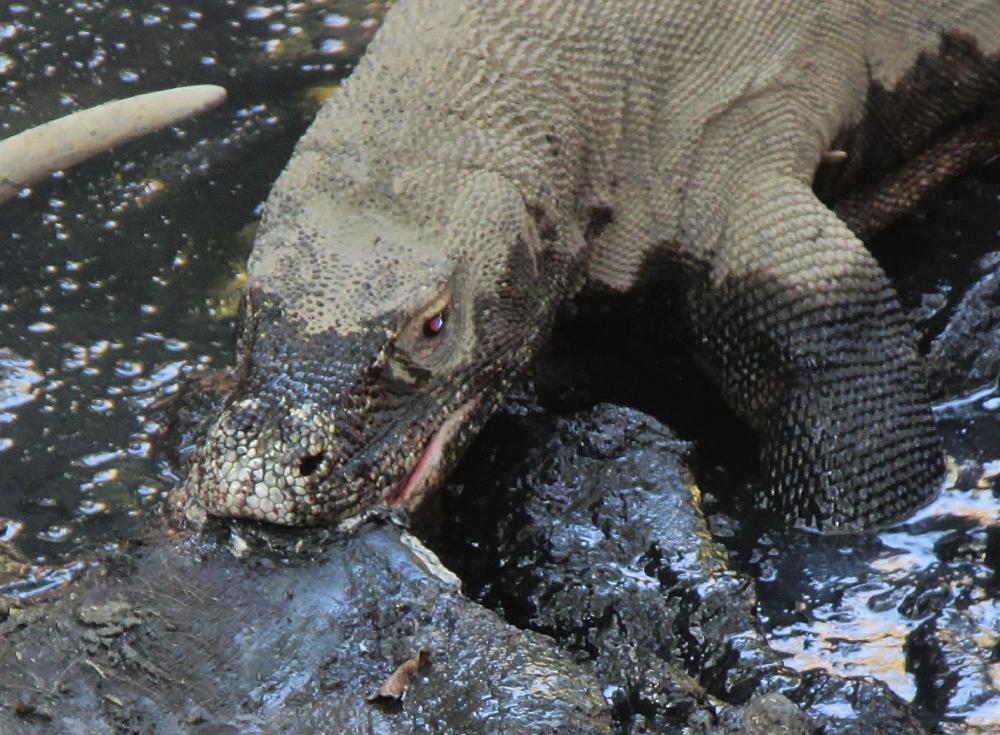
24 August 2016 | Rindja Island, Indonesia
22 July 2016 | Fannie Bay, Darwin, Northern Territory, Australia
14 June 2016 | Pancake Creek, Queensland, Australia
13 June 2016 | Pancake Creek, Queensland, Australia
11 June 2016 | Burnette Heads, Queensland, Australia
07 June 2016 | Mooloolaba, Queensland, Australia
11 May 2016 | Colmsie, Brisbane River, Queensland, Australia
23 December 2015 | Brisbane, Australia
13 August 2015 | Whangarei, New Zealand
07 August 2015 | Whangarei, New Zealand
23 July 2015 | Whangarei, New Zealand
12 April 2015 | Whangarei, New Zealand
11 February 2015 | Whangarei, New Zealand
25 January 2015 | Whangarei, New Zealand
24 September 2014 | BORA BORA, French Polynesia
23 September 2014 | Bora Bora
TIGER LILLY'S AMAZON DELTA CRUISE - PART 4
21 November 2013 | AFUA TO THE SEA BUOY
Tom and Lilly aboard S/V Tiger Lilly
AFUA to the RIO AMAZON SEA BUOY
It has been a life-long dream to sail Tiger Lilly to the Amazon Delta, and to explore the region from the comfort of our sea going home. Our Amazon Delta cruise was part of a larger voyage down the northeast coast of South America, exploring the tropical rivers of the Rio Orinoco Delta in Eastern Venezuela, Guyana's Essequibo River, the Suriname River, the River Maroni in French Guiana, and finally the Amazon Delta. Our exploration of the Amazon Delta was was divided into three parts: First, we entered the region on the deep, wide, Rio Para on the south side of Ilha De Marajo, and called at the village of Soure, and the big city of Belem; Second, we cruised through the maze of creeks and small rivers west of the island of Ilha De Marajo between the frontier towns of Breves and Afua; and finally we exited the Delta via the Canal Do Norte of the Rio Amazon. From the Rio Para sea buoy to the Rio Amazon sea buoy we spent over two months during the 2013 dry season (August to October) cruising some 560 miles of the Amazon Delta region - mostly under power. This final section of a three-part blog on cruising the Amazon Delta covers the area from the town of Afua on the Rio Amazon's Canal Do Sul out to the Rio Amazon Canal Do Norte sea buoy.
Initially, we thought of Afua as the end of our cruising in Brazil. We planned on taking short hops between the islands that make up the mouth of the Rio Amazon, then make a long run for the sea buoy, and finally head northwest - back to the azure waters of the south-central Caribbean. But instead of hoisting the dinghy on deck at Afua, as was our original plan, we towed Grace through the mouth of the Amazon; and it turned out that the outer islands of the Amazon Delta were a destination in and of themselves. We had a very interesting and enjoyable cruise through the islands at the mouth of the Rio Amazon. In spite all the negative opinions we heard from the Caribbean "experts" (most of whom had never been south of Trinidad) regarding security in Brazil, the highlight of our Amazon Delta cruise was the wonderful reception we received from the friendly Brazilian people - we were warmly welcomed and treated like special guests everywhere we went; and we had ZERO security incidents in Brazil.
OFFICIALDOM
When we checked out of Brazil at Belem, we listed the connecting waterways to the west of Ilha De Marajo, and the Rio Amazon as our departure route; and the Port Captain approved of our plan - but it is hard to know if he really knew what he was approving since neither of us spoke or read the other's language. He was most cooperative, and he signed and stamped the form we filled out in English, and that was good enough for us. At any rate, during the next month, as we worked our way through the back waters of the Delta, we saw no official presence anywhere; so no one asked to see our papers anyway. When we checked-in at Bonaire, after some six weeks off the official grid, we turned in our Brazilian Zarpe and told them where we had been, and when we had actually sailed from the mouth of the Rio Amazon, and they did not seem at all concerned.
AFUA
Afua is a delightful little town; it is clean and colorful; and the people welcomed us wherever we went - they all knew that we were from the American yacht anchored on their waterfront. Afua is a major supply point for the outlying area, and there are several stores with good supplies of fresh provisions and groceries. Called the Venice of Marajo, the town is built above a swamp, and the buildings are set on pilings about five feet above the mud. The walkways between the homes are narrow, and there are no motor vehicles in town - just lots and lots of bicycles. The homes are tidy and well-maintained, the people take a great deal of pride in their town - and it is quite safe. Afua is surrounded by water; the Canal De Afua to the west, the Rio Cajuuna to the north, and the Rio Marajozinho to the south and the east. It has a fuel dock on the south, or Rio Marajozinho, side of town; an ocean going sailing yacht can get alongside only on a high tide - but with an average tidal range of twelve feet, that is no problem. In October of 2013 diesel fuel cost 2.75 Real per liter at the Posto Beira Rio fuel dock (cash only), and 2.4 Real equaled one US Dollar. There is a branch of the Bank of Brazil at Afua with an ATM. Our credit cards and debit cards worked at the bank, and the larger stores; so getting money was not a problem. There is a small hospital in Afua, with a doctor on duty, and there is an airstrip with scheduled flights to other towns in the region. Anyone who gets hurt in the back water area (west of Ilha De Marajo) will be transported by fast boat to Breves or Afua, treated there, or flown on to Belem. On the north side of the town's Canal Afua waterfront is the school and covered mini-soccer / volleyball / basketball courts. In the area by the athletic arena we connected to free WI-FI. It was most enjoyable to sit and watch the spirited soccer games (Brazilian football) in the cool of the evening, and Afua is a place we were quite safe after dark. We wanted to stay longer than eight days, but we have a self-imposed date with the Panama Canal - and we had to get Tiger Lilly on the move again.
ANCHORAGES ON THE RIO AMAZON
These are Tiger Lilly's anchorages at the mouth of the Rio Amazon:
0-09.5S 050-23.6W town of Afua
0-01.7N 050-35.3W Arquipelago Jurupari, Furo Grande
0-26.4N 050-25.6W Ilha Caviana, Rio Acaituba
0-45.8N 050-07.2W Ilha Do Curua, Igarape Grande Do Curua
These anchorages are all in the vicinity of homes (an important part of our security plan), and are about 30 miles apart; close enough to advance between them regardless of the state of the tide / current - which was difficult to predict with only the tide tables. The tides and currents on the Rio Amazon's Canal Do Sul and the Canal Do Norte are widely different in height, velocity, and timing, and to complicate predictions, these two large and dynamic bodies of water are cross-connected at several points. We used the tide tables on our Navionics iPad application for tidal information; but we were unable to find any current tables for the mouth of the Rio Amazon - the river pilots who guide the commercial ships into the Rio Amazon probably have current charts available, but we could not get access to them. We looked for experienced captains on Afua's waterfront to tell us what they knew of the mouth of the Amazon; but almost all of the boats working out of Afua shuttle people and cargo back into the interior of the Delta region, not out towards the sea. The timing of the tide at Afua seemed to be closer to the tides on the Canal Do Norte rather than the nearer Canal Do Sul tide station. The range of the tide varies a huge amount in a relatively short distance: Ponta Pedreira on the Canal Do Sul ranged about 14 feet and was a full cycle out of phase time-wise with the tide at Macapa; the tide at Macapa, some 110 miles upstream from the Rio Amazon sea buoy ranged only 8 to 9 feet; the tide at Limao, some 60 miles from the sea buoy, ranged about 13 feet, only 12 miles NE of Limao at Barra Norte the tide ranged about 16 feet; 75 miles NW of the sea buoy at Ilha De Maraca, at Igarape Do Inferno (a hint) the tide ranged some 30 feet. Trying to figure out what the tide or current would be doing in advance at any particular location between these stations was harder than Chinese arithmetic, and it made my hair hurt thinking about it.
Lilly sez: What hair?
By planning short 30 mile hops to exit the Rio Amazon Delta (starting at Afua), we were always able to make our next anchorage with plenty of time to get settled and meet the local people - an important element in Tiger Lilly's security plan. The single side band radio Coconuts Net, the Caribbean Maritime Mobile Weather Net, and the Amateur Radio (HAM) Winlink email was our only contact with the outside world while we were in the remote areas of the Amazon Delta, and it was great to hear some familiar voices. We could not always get out on HF radio, but George, on the Caribbean Maritime Mobile Weather Net, would transmit weather to the boats on the northeast coast of South America in the blind. Thank you George! No one speaks English on the VHF, except the big commercial ships transiting the Rio Amazon. We kept our family and friends up to date with our position and activities by remote posting to this blog with the Winlink / Sailblogs application.
PILOT NOTE
The electronic charts of the Canal Do Norte area appear to be generally offset to the north; and in most areas the Navionic charts more accurately depict the waters of the Amazon Delta Region then do the C-MAP NT+ charts. We downloaded the free Brazilian Navy costal charts, and installed them on our laptop Open CPN navigation program; but we don't usually use that system to navigate in real time - we use Open CPN on the more vulnerable laptop as a planning tool. We had a few outdated paper charts aboard just in case we got hit by lightening, and all the little silicon brains aboard Tiger Lilly were rendered inoperable.
There is a large shoal off the NW corner of the Arquipelago Jurupari circumscribed by:
0-09.8N 050-39.6W
0-12.2N 050-39.5W
0-15.2N 050-38.4W
This is a dangerous area, charted east of the actual location, with large snags and on-setting currents; we watched the fathometer, stayed in 30 feet of water and well clear.
MOUTH OF THE RIO AMAZON
Ilha Do Curua, Igarape Grande Do Curua was our staging-for-sea anchorage (0-45.8N 050-07.2W), and it turned out to be a good choice for that purpose. It was an easy entrance / exit (favor the east point on the entrance toward the pier ruins, then down the middle between the banks), the anchorage was sheltered and quiet, and the creek was well populated - we did not have to worry about security issues at our last anchorage in Brazil. It was here we hoisted the dinghy on deck, and secured Tiger Lilly for sea. The final leg of our Rio Amazon Delta cruise was 60 miles, from Igarape Grande Do Curua out the Canal Do Norte to the sea buoy. There was no way we could get out to the sea buoy on a single ebb, so our strategy was to leave at first-light - making the most of the available daylight. We made an average of 7 knots good on the ebb, and less than 3 knots on the flood, but we kept moving. We were concerned about having to navigate around un-lit fishing nets in the dark, but it turned out not to be a problem. We only came across two boats with nets deployed, and they were well to the north of the ship channel on the shallow banks of which we were staying clear. We generally stayed close to the shipping channel as we worked our way to the northeast, and that strategy kept us clear of the shallow banks which can be difficult to navigate around in circuitous on-setting currents. The electronic charts were pretty close to accurate; however, sometimes the charted depths varied quite a bit - but we could always head for the marked big ship channel when in doubt. Early in the morning the wind is generally light at the mouth of the Rio Amazon, but by mid-morning it usually fills-in brisk from the east. The seas stood right up on the ebb, and laid down on the flood. It was not pleasant work; we were either slow on the flood, or uncomfortable on the ebb - but not usually both. We had so many enjoyable memories of the Amazon Delta that it was certainly worth the difficulty.
Lilly sez: So says the guy who didn't have his head in the Lilly Bucket - feeding the fish!
Our general course was northeast, and we motor-sailed short port tacks, and long starboard tacks all the way out. It took us 18 hours of motor-sailing and six tacks, to get out to the vicinity of the Rio Amazon sea buoy; where we secured the motor, set the vane gear self-steering, and started sailing again. We took our departure northeast of the sea buoy, out on the five fathom curve, and headed northwest up the coast of South America.
It would be possible to sail out of the mouth of the Rio Amazon, but progress could only be made on the ebb. With all the large debris (we saw entire trees floating down the river), we would not want to be moving around in the mouth of the Rio Amazon during the hours of darkness, nor would we want to have to anchor there. By our way of thinking, time was of the essence - we wanted to get out and get headed clear as soon as possible. We reckon that under sail alone, with the east-northeast wind we had, it would take two days of sailing the ebbs, and the weakest part of the flood tide, to get out and clear, and that would require sailing during the hours of darkness in the mouth of the river - and so we motor-sailed our way out.
IMPORTANT NAVIGATION WARNING: STAY WELL CLEAR OF ILHA DE MARACA!
Some 75 miles north of the Rio Amazon's Canal Do Norte sea buoy is the island of Ilha De Maraca. The currents in this area make it a treacherous place to navigate, and no place for a yacht. The tides at the Igarape Do Inferno (well named) have a range of 30 feet. Add to this circular tidal current the outflow of the Rio Amazon, the largest river in the world, which bends northwest on the prevailing ocean current towards Ilha De Maraca. In fact, if you added up the volumes of the next seven of the world's largest rivers they would not be equal to the Mighty Amazon. Finally, the North Equatorial Current piles up on the continental shelf just east of Ilha De Maraca like a west bound freight train from Africa, with an incredible two and three-quarter knots of current. When these three very strong forces intersect from different directions they produce local conditions that a sailing yacht simply cannot overcome. When we were sailing south from Cabo Orange on the way to the Amazon Delta, we hugged the shore to stay out of the Guiana Current; but we stayed close too far south, and when we tried to come back east over the top of Ilha De Maraca it took all the power in our sailing rig (with 15 knots of wind) AND three-fourths of our engine power SIMULTANEOUSLY to clear the shoals off Cabo Raso Do Norte. The sea was horribly confused with giant up-wellings, and our track looked like an Aides Ribbon as it looped back across itself - Tiger Lilly was completely at the mercy of the combined circular ocean current.
Lilly sez: OH MY GOSH - WHAT A MESS! I felt like I was in a chocolate milk shake - still on the blender, and it happened in the dark of the night. There were thick gobs of brown muddy water EVERYWHERE on Tiger Lilly as the confused sea sloshed over the decks and cabin top. STAY OUT OF THIS PLACE!
If you are heading north this problem with the current north and east of Ilha De Maraca is not an issue, the Guiana Current and the outflow from the Amazon are both helping you along - just stay out on the Ten Fathom Curve (or deeper) for a free ride. If you are headed south from Cabo Orange, we would recommend staying well clear of Ilha De Maraca; which means biting-the-bullet and bucking the Guiana Current out on the Five Fathom Curve - and get out there early, Farol Calcoene, at about 2 degrees 30 minutes north, is where we should have angled out to the southeast. A word to the wise should be sufficient - don't make the same mistake we did.
SECURITY
Our best security asset where ever we went was the local people. In this remote and sparsely patrolled area, they have to deal with the bandit problem themselves, and the local folks know best how to avoid trouble. The evil ones do their wicked work in the dark, away from witnesses, and away from potential help for the victims. We were quite safe anchored in front of the good people's homes. When we first come down their creek and into view, most of the people were usually very shy, peering out from behind a door, or peeking out a window, while the family dogs barked out the arrival of Spaceship Tiger Lilly. We always asked if we could anchor - by sign language, of course. Then Lilly would row in and break the ice with the kids, and get them rowing around with her in Grace the dinghy. Soon, the parents, cousins, aunts and uncles, and neighbors were all on the dock, laughing and enjoying the antics of their kids rowing Grace - we call it dinghy diplomacy. The local people think it strange that white people sit facing aft, looking over their shoulder, and row with long flat sticks instead of paddling a canoe in the proper manner; but they were certainly curious to try it our way. On their invitation, Lilly would then climb up on the family dock, whip out her trusty iPad and present a quick slide show of our South American cruising, along with pictures of our extended family. The pictures quickly overcame the language barrier, and she had a grand time with our new friends. She established a genuine connection between them and us, and it was clear that the people truly cared about our safety. Almost everyone living on these back waters has a cell phone - usually a smart phone that provides their email, path to the Internet, and serves as a computer. Lilly usually came back to the boat with a new Facebook friend and a couple of email addresses. At about 2200 the family's electric generator was secured, everyone went to bed, the creek was dark and quiet, and the local dogs were on watch. We did not have a single security incident anywhere we cruised in the Amazon Delta region - we hooked-up with the local people, and we heeded their counsel regarding our route and anchorage sites. Our choice is no guns aboard Tiger Lilly. Guns usually escalate a situation, and that is exactly the opposite course of action we desire. If the bad guys come, they just want stuff and money - so if it ever happens to us, we will give it to them. The real key to effective security is not weapons, but rather avoidance of dangerous areas in the first place, and the local people were our best source of information. Obviously, there is some risk involved in cruising these remote areas, but it is a calculated risk - and staying in nice comfortable / safe Suburbia USA isn't how we choose to live our lives.
Lilly sez: The most important part of Tiger Lilly's Security Program is Psalm 91 - I will say of the Lord "He is my refuge and my fortress, my God, in whom I trust." If you make the Most High your dwelling - even the Lord, who is my refuge - then no harm will befall you, no disaster will come near your tent. "Because they love me," says the Lord, "I will rescue them; I will protect them, for they acknowledge my name. They will call upon me, and I will answer them; I will be with them in trouble, I will deliver them, and honor them. With long life I will satisfy them and show them my salvation." Hey you guys, the spiritual life is NOT A THEORY - IT WORKS IN THE REAL WORLD! Just invite the Lord aboard - every day. He will go with you to the Amazon Delta, or anywhere you want to go! God loves YOU!
ON TO THE ABC'S
Once clear of the mouth of the Rio Amazon we made a ten and a half day, 1,550 mile passage direct to beautiful Bonaire in the south-central Caribbean. The Inter Tropical Convergence Zone was up at nine north as we sailed along the South American coast, but the wind stayed up, and we actually caught some much-needed rain after a long dry spell in the Amazon Delta - whoda thunk THAT was going to happen! The Tiger was out, and in her element on the briny blue again; sailing wing-on-wing and headed northwest for Galleons Passage. With the wind at our back and the Guiana Current helping us along, it was an easy sail back to the Caribbean from Brazil. Bonaire was a great place to just swim, eat and nap after our passage. Our seven month 4,500 mile cruise to South America and back took its toll on Tiger Lilly's material condition, and she was overdue for some TLC and repair work, so we headed just over the horizon to the Spanish Waters of Curaçao - after a short stop at the lovely little island of Klein Curaçao. The ABC islands are a good place to work on the To-Do List, and ship-in needed parts and supplies from the States.
LILLY SEZ
OH MY GOSH, it was SO good to see other cruisers again when we got to Bonaire! For 220 days I only had Tom-Tom the Sailor Man, the monkeys, and the Indians to talk to - ladies, do you have any idea what THAT was like? (Well, in all fairness, the Indian ladies were very nice - at least they TRIED to talk - and the monkeys were quite interesting to watch.) There were probably 2000 boats in Chaguaramas when we left Trinidad in April. Do you know, we could not find even ONE brave soul in that whole population of "cruisers" willing to disregard the naysayers and come south to the beautiful tropical rivers of South America? What is up with that? Is Mexican Train Dominoes at Crews Inn THAT much fun? Let me ask you something: Is that what you had in mind when you and hubby plopped down your life savings, bought that boat, and sailed off to the sailing adventure you dreamed about? Think about it - if I can sail down the northeast coast of South America, so can YOU! Ladies, jack-up your men, stiffen up their courage, put a little wander-lust in their granola; tell them that if Tiger Lilly can do it, so can you! We did not have even a single security incident in the five South American countries we cruised in seven months. We hope that you can find a like-minded buddy boat or two, and come explore this wonderful destination. Why lie in your bunk and watch National Geographic Specials, wishing YOU could do something special? Get going, and find YOUR special adventure in life!
CRUISING PLANS
We are posting this blog from Curaçao. Our current cruising plans call for working on the boat here for the next six weeks or so; then on to Cartagena, Columbia for a port visit (although we are having some second thoughts since we heard that it will cost over $300 to check-in there - and we only intend to stay a week or less), cruising the San Blas Archipelago of Panama, transiting the Panama Canal, and then sailing for the South Pacific in early 2014.
We would like to congratulate the crews of the ten boats which sailed down to Guiana during this past hurricane season from the Eastern Caribbean - we could tell by the radio traffic and emails that you had a wonderful experience on Guyana's Essequibo River - and some of them plan to head further south. The northeast coast of South America is an interesting and safe place to cruise during the West Indian hurricane season; the South American dry season provides the best time to explore the region, and the passage back to the Caribbean in November is quick and easy. The irony of some of the Caribbean "experts" and "old hands" telling us how dangerous South America is, while they sail up-island to the Windward Islands and the Leeward Islands in October is not lost on us. We thoroughly enjoyed northeast South America; exploring the tropical rivers, seeing the wild life, and meeting the friendly people of the region. Our trip up a winding creek off the Rio Acaituba was our last touch with the Amazon jungle before we had to go to work and prepare Tiger Lilly for sea; as we quietly rowed up the tree-lined cano, six huge scarlet macaws flew right over the top of us on the way to their evening perch, a family of pink river dolphin were frolicking and feeding on the flood tide, and we could hear a toucan call to his mate in the canopy, just before the burnt orange orb of the sun set below the tree tops off to the west - all lasting memories of an enchanted land to be sure. Come and see this captivating place called the Amazon Delta for yourself!
If you click on our PHOTO GALLERY in the upper right corner of this page and follow the logic tree thusly: Ports of Call, South America, Brazil, Amazon Delta - you can view pictures of Tiger Lilly's Amazon Delta cruise. See you there!
Comments
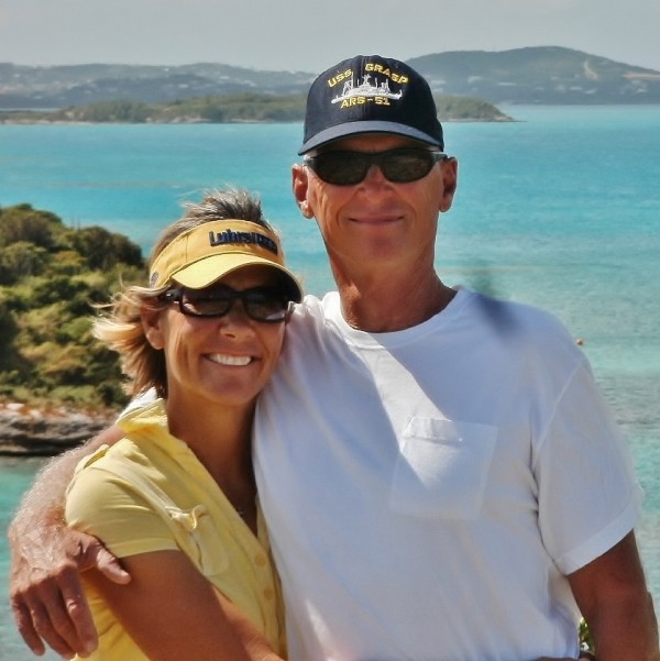
| Vessel Name: | Tiger Lilly |
| Vessel Make/Model: | 1977 CSY44 walkover hull #55 |
| Hailing Port: | Green Cove Springs |
| Crew: | Lilly and Tom Service |
| About: | |
| Extra: | |
| Social: |
|
Tiger Lilly's Photos - Main
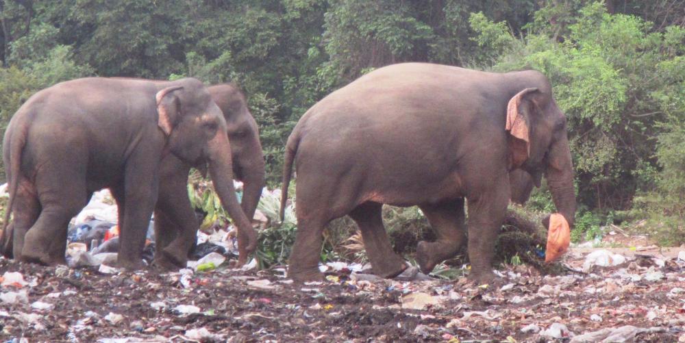 |
Approximately 100 Asian elephants live in and around the Trincomalee Landfill in northeast Sri Lanka. These huge creatures eat plastic strewn trash and garbage because they have been driven back from their natural habitat by the encroachment of farms.
38 Photos
Created 24 September 2018
|
 |
.JPG) |
.JPG) |
 |
 |
 |
 |
 |
 |
 |
S/V Tiger Lilly
Who: Lilly and Tom Service
Port: Green Cove Springs
Gallery