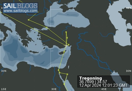
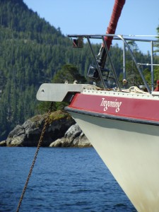
Tregoning
12 April 2024 | We are back aboard Tregoning in Mersin Marina, Mersin, Türkiye
02 April 2024 | We are in Toronto Airport, Canada: Tregoning is in Mersin Marina, Mersin, Türkiye
25 February 2024 | We are back in Gainesville, FL: Tregoning is in Mersin Marina, Mersin, Türkiye
18 February 2024 | We are in Glenwood, New Mexico: Tregoning is in Mersin Marina, Mersin, Türkiye
12 February 2024 | We are in Morro Bay, California: Tregoning is in Mersin Marina, Mersin, Türkiye
19 January 2024 | We are in Vancouver, BC Canada: Tregoning is in Mersin Marina, Mersin, Türkiye
01 January 2024 | We are in Washington State: Tregoning is in Mersin Marina, Mersin, Türkiye
15 December 2023 | We are in Minnesota: Tregoning is in Mersin Marina, Mersin, Türkiye
18 November 2023 | We are in Florida: Tregoning is in Mersin Marina, Mersin, Türkiye
29 October 2023 | We're in Florida - Tregoning is at B-dock, Mersin Marina, Mersin, Türkiye
21 October 2023 | 7 Oda Kapadokya Cave Hotel, Ürgüp, Türkiye
14 October 2023 | Hotel Aşikoğlu, Boğazkale, Türkiye
07 October 2023 | B-dock, Mersin Marina, Mersin, Türkiye
19 September 2023 | “Chez Jon & Angela”, Near Otterton, Devon, UK
14 September 2023 | Airbnb in Fortuneswell on the Isle of Portland, Dorset, UK
11 September 2023 | With Mike, Grange-over-Sands, Cumbria, UK
03 September 2023 | Ardington House, Ardington, Oxfordshire, UK
24 August 2023 | Near "Chez Joan and Peter", College of Roseisle, Moray, Scotland
11 August 2023 | Andrew's house (not exactly), Lichfield, UK
22 July 2023 | Chez Gail, near the New York Café, Budapest, Hungary
Large holes in the ground and more birds
20 August 2021 | Malanda Manor Guesthouse, Malanda, QLD, Australia
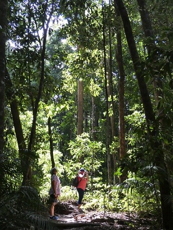
Alison Stocker | Photo: Sue and Lynne in a sunlit gap in the Mossman Gorge rainforest
The third day of our vacations from our boats started with one of us having to do some work...
...Andrew had to attend a Zoom meeting for most of Wednesday morning (18th August), while the rest of us dispersed to participate in the type of activities that he was least likely to want to do. Prior to settling in front of his laptop, Andrew had joined Randall and me for our pre-breakfast walk and bird survey. We took a different road away from the Manor, and our sightings included several golden-headed cisticolas and bush stone-curlews.
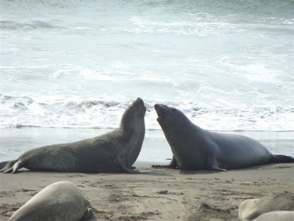
After breakfast, Sue, Graeme, and Jamie visited the Historic Village at Herberton where there were many collections of old buildings, vehicles, John Deere equipment, tools, dolls, toys, etc. The intent was to find something that would hold Jamie's interest, but it was evident that Graeme was rather excited about seeing what was in The Tool Shed. Meanwhile, Randall and I took Lynne to see a big hole in the ground and a bunch of birds.
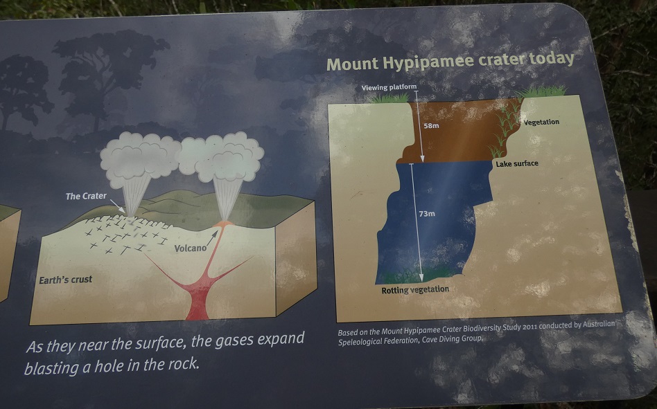
Part of the interpretive sign at Mount Hypipamee National Park
Leaving Andrew at Malanda Manor Guesthouse and following some backroads with attractive views, we arrived at Mount Hypipamee National Park, one of the places that I had particularly wanted to visit. After wandering along a trail through the rainforest, we arrived at what appeared to be a huge sinkhole, about 70 m in diameter (230 feet). Rather than a hole that collapsed downward, we were looking at a volcanic vent, called a diatreme or volcanic pipe (but on the signs, rather confusingly, usually called a crater), which was formed by the explosive release of gases throwing rocks upwards from a side vent of a volcano.
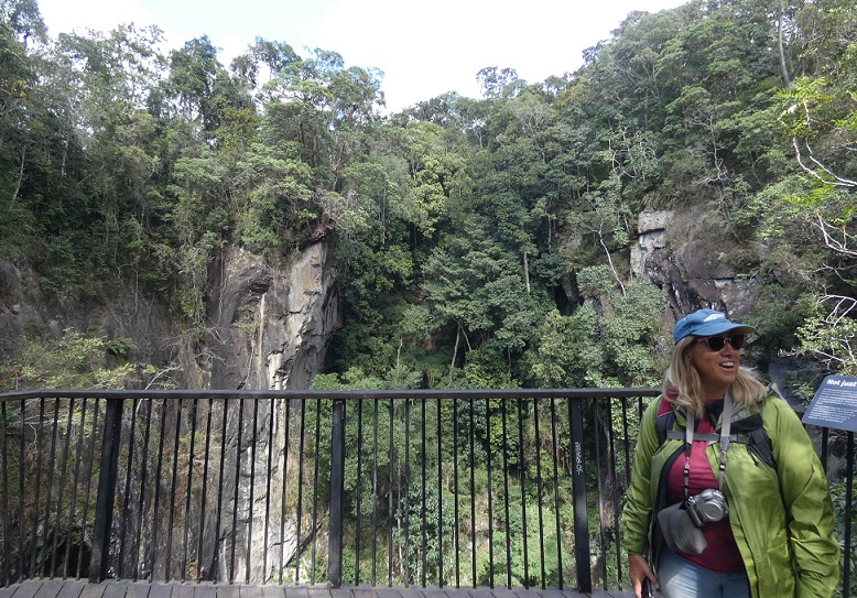
Lynne on the viewing platform at the Mount Hypipamee Crater
The sheer sides of the vent dropped 58 m (190 feet) from the viewing platform to the surface of the water which was covered with a bright green carpet of duckweed. On the far side, the cliffs rose for a similar height above the platform with trees, surrounding the rim and clinging tenaciously to any cracks or ledges large enough to harbor sufficient soil for survival. Below the water surface, the vent descended a further 73 m (240 feet), as had been measured by divers, whose method of entry and exit from the pool must have been quite interesting.

The opposite side of the Mount Hypipamee Crater from the viewing platform with the duckweed covering the water that fills about 56% of the vent below the platform
It was difficult to take pictures that did justice to the impressiveness of this giant tube rising through the mountainside. I had really picked this as a National Park worth visiting because it was mentioned as being good for birding, so the dramatic scenery was better than I had anticipated. And then it seemed that the birds sent an emissary to make sure that we did not ignore them...a peregrine falcon.
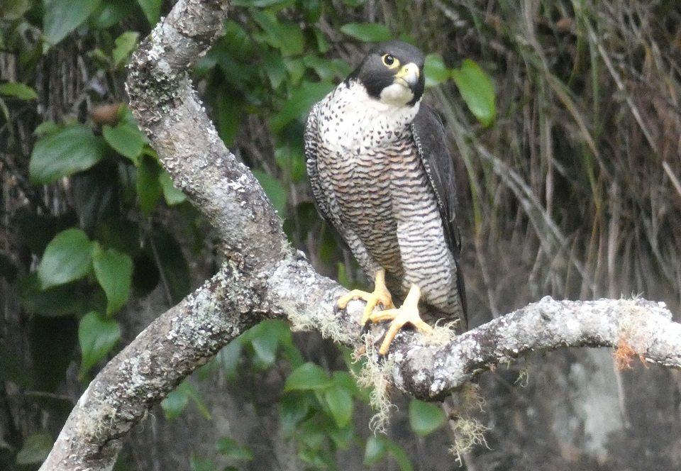
Being stared-down by a peregrine falcon (to 48 cm or 19 inches) at Mount Hypipamee volcanic vent
Actually, there were two falcons but we saw one and only heard the other. The one that we saw, came into the crater and circled once, then went up high and started to make a fast dive towards the water. I gasped as it seems unlikely that it was after prey in the duckweed. The dive was aborted below the viewing platform and the magnificent raptor flew up to a branch that was at about the same height as us, but across the crater. It stared at us intently, adjusted a few feathers, responded to its mate calling from behind us, and then launched itself back into the crater. A couple more circles inside the vent to gain altitude, and then it flew over our heads into the forest to follow the calls of its companion.
We had been treated to a few minutes in the presence of majesty. Never have we had such a good views of a peregrine falcon in the wild. It may not have reached a great speed during its short dive into the vent, but there was no mistaking the capability in the throwing back of its wings. Diving peregrine falcons are not only the fastest bird in the world, reaching speeds of more than 320 km (200 miles) per hour, but are the fastest animal on earth. With 16 subspecies recognized, breeding populations of these falcons are found on every continent except Antarctica.
Thoroughly impressed, we continued along the loop trail wondering what else this Park might have to capture our attention. Notable were several huge elkhorn ferns, balanced at our eye-level in trees that scarcely looked strong enough to support them.
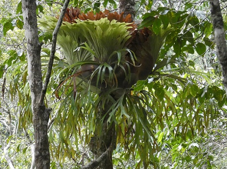
A large elkhorn fern
A sign next to a yellow mahogany tree, described the phenomenon of cauliflory, where flowers are borne directly on the tree trunk and older branches. More familiar examples include cocoa, papaya, and jackfruit. Ironically, cauliflowers are strictly not cauliflorous. The specimen near the sign had many clumps of flowers on the trunk but they were rather small and inconspicuous. As is often the way, once we started paying attention, we subsequently saw many better examples with more showy flowers.
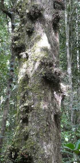
Clumps of cauliflorous flowers on the yellow mahogany tree by the interpretive sign in Mount Hypipamee National Park
The adaptive strategy of cauliflory is that bearing flowers and fruit at an intermediate height in the forest can attract pollinators and seed dispersers from both the canopy above and the forest floor below. Cauliflory is beneficial to fruit bats because the flowers and fruit are separated from the network of branches where wings may become entangled.
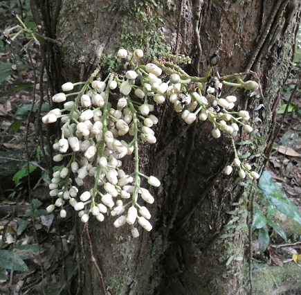
Cauliflorous yellow mahogany flowers seen later at Mossman Gorge
Although the plants and birds in Mount Hypipamee National Park were keeping us occupied, geology had the last word. Quite separate from the water in the base of the volcanic vent, but not far away, flowed the Barron River. This waterway collects rainfall from a large area of the Atherton Tablelands before descending from the plateau and passing over the Barron Falls near Kuranda. Sadly, we would not have time to take the Kennedy Highway to Kuranda or these Falls, but we were able to see the smaller Dinner Falls in the headwaters of the Barron River. Unlike at Josephine Falls at the foot of the plateau, these Tableland cascades were not particularly full but they were very pleasant. The origin of the name Dinner Falls is uncertain, but possibly relates the three tiers to the three courses of dinner.
The middle tier of Dinner Falls in Mount Hypipamee National Park
This is a slightly less imaginative name origin than is proposed for the National Park itself. From Wikipedia: "The name Hypipamee is a corruption of the Aboriginal word, nabbanabbamee, which is connected with a legend of two young men who cut down a sacred candlenut tree, only to be swallowed up by a large hole in the earth, the crater." On the other hand, the link between "a three-course dinner" and "three tiers" seems a bit more obvious to me than between "Hypipamee" and "nabbanabbamee"...
Leaving the National Park, we drove north to the edge of Atherton, on our way to revisit Hasties Swamp National Park. Before turning off the main road we glimpsed some large grey and red birds in a ploughed field, probably sarus cranes. The road was busy so we did not stop but assumed that we would see some of the cranes at the Swamp, as we did last year.
We were not only wrong to expect the presence of sarus cranes, but the whole waterfowl population of the lake within the Nayleta Wetlands seemed to be different and was apparently much reduced. Instead of the hundreds of hardhead ducks that had covered the lake late last September, we saw quite a large number of magpie geese around the north end but few birds on the open water. We were arriving later in the day than on our previous visit, but it was still worrying that the water fowl population seemed to be so reduced.
Once we climbed into the two-storey bird hide, we wondered where the loud, shrill calls were coming from. There did not seem to be enough birds nearby to sustain that volume of sound. Then we looked down into the wide fringe of aquatic plants and noticed hundreds of brown ducks, mostly napping with their heads turned backwards and tucked under a wing. But enough of them were awake to be making the whistling noises, and a few were swimming along the edge of the vegetation, allowing us to identify quickly them as plumed whistling-ducks.
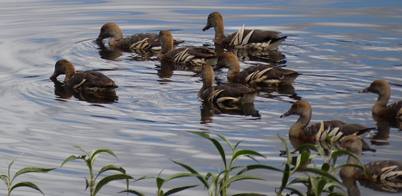
Plumed whistling-ducks (to 61 cm or 24 inches) showing with their pale plumes
On closer inspection, we noticed quite a few other species around the lake edge but we did not linger and take a bird survey as we needed to return to Malanda and rescue Andrew by lunchtime. Lynne seemed to be suitably impressed, once we had found all the ducks, and I think that we can make a birders of her and Andrew yet!
L to R: 4 plumed whistling-ducks, 3 magpie geese, 2 Pacific black ducks, and an Australian darter sharing a log at Hasties Swamp...is this part of an Australian bird-themed Christmas carol?
We also noticed a large manically smiley-faced moth in the bird hide which I think is a wood moth (Hulodes caranea).
On our way to pick up Andrew and have lunch in our rooms at Malanda Manor, we stopped briefly at Gallo Dairyland. We were not interested in a tour of the dairy farm or the food production facilities, but we did buy some gourmet chocolates and cheeses that had been made on site. YUM YUM!
Once we were fed and had collected Andrew, we headed south from Malanda. Stopping briefly to admire the pastoral landscapes from the Millaa Millaa Lookout, we then continued on to Ravenshoe. We had some debate about whether it was Ravens-hoe or Raven-shoe but did not bother to stop and ask (...it is the latter according to the internet).
The view east from Millaa Millaa Lookout with a cloudy sky but much better visibility than the day we arrived from Cairns
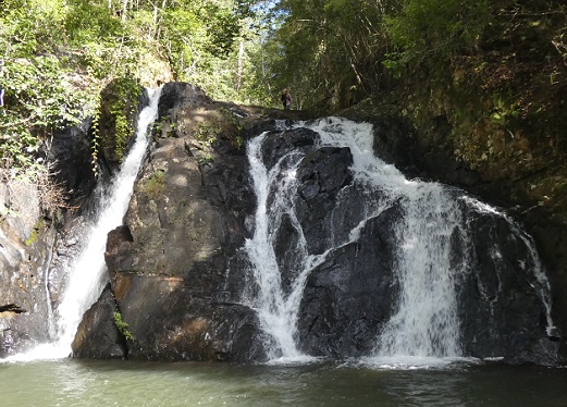
Our first destination of the afternoon was another of my "must see" choices, Big Millstream Falls. They were attractive Falls as the water dropped over the erosion-resistant edge of a columnar basalt lava flow, but the real reason for my interest was that they are "reputed to be" (is nobody quite sure?) the widest single-drop fall in Australia. Actually, I have not been able to find any data online that provides the actual width (or other dimensions) of the Falls. And does this oft-repeated, but apparently unsubstantiated, evaluation of "widest" include the section of falls to the right of the main fall but which are not visible from the viewpoint?
Big Millstream Falls
I estimated that the visible part of these Falls were less than 100 m wide but, as Randall would put it, "that is a wild-ass guess". Regardless of the exact size, this pales into insignificance compared to the 832 m (2,730 feet) width of the Horseshoe Fall at Niagara, Canada, the 1,708 m (5,604 feet) width of Victoria Falls on the Zambia/Zimbabwe border, or the world-record width of 10,783 m (35,377 feet) of the Khone Phapheng Falls in southern Laos. Of course, given how much of Australia's area is extremely dry, the absence of huge rivers with correspondingly wide waterfalls is not surprising.
The open eucalypt forest surrounding the Big Millstream Falls was quite different from the rainforest that we had been walking through on most of our trip so far. The change from wet to dry landscape seemed to occur as we approached Ravenshoe. This region was the traditional country of the Jirrbal Aboriginal people who lived in the rainforest areas in semi-permanent villages. The drier, flatter areas would have been more attractive to the European farmers who extensively settled the Atherton Tablelands.
During World War II, the Tablelands were identified as a suitable area for training and rehabilitation camps for Australian military forces. Close to the battlefields of Papua New Guinea, with a climate cooler than the coast, and environments similar to parts of Southeast Asia, 160 sites were established in 1943. At a given time, up to 100,000 troops from 320 army and ancillary units were located in the Tablelands.
After our stroll down to see the Falls, we followed a loop trail through the open woodland that explored the camp sites that were constructed for the Battalions of the 7th and 9th Divisions between 1943 and 1945. Holding almost 1,000 men, each campsite had mostly tent accommodation and cooking, latrine, and washing facilities. Now, however, there is nothing to see other than some interpretive signs, a stone fireplace, and a few lines of stones that edge the network of rock-lined granite paths and roads that linked the facilities. A pleasant enough woodland amble but rather underwhelming unless you are a WWII buff.
Our next destination, about 26 km (16 miles) to the west, was Innot Hot Springs Scenic Reserve, a site that particularly intrigued Randall. Fractures reach 600 m (almost 2,000 feet) deep in the rocks underlying the sandy alluvial surface sediments of this area. Water seeps down some of the fractures to become heated when in proximity to the volcanic magma chambers. This expanded, pressurized hot water then rises in other fractures, reaching the surface as hot springs. By the 1890s, Innot Hot Springs were so popular and had such alleged medical benefits, that two hotels and a bathhouse were built at the edge, and the water was being bottled in Townsville for export to Europe.
Now there is a large campground next to a wide shallow stream into which the hot springs rise. People dig holes in the sandy sediment in which to bathe, a bit like at Hot Water Beach on the Coromandel Peninsula in New Zealand, but without the refreshment of each high tide. A dozen people were sitting in shallow pools, enjoying the warm waters. Randall boldly flopped into an empty puddle downstream of the other people. Andrew eventually joined him but Lynne and I were not as impressed, put off by the water's very slow flow and green tinge. Maybe on a cold day it might have been tempting...
Randall sort-of enjoying the Innot Hot Springs
The final spectacle for the day, was at the end of a detour from Ravenshoe, down a windy road through dark rainforest, to the lookout point for Tully Gorge and Falls. The main access for white-water rafting in Tully Gorge is much further downstream, via the town of Tully which is on the coastal highway, and cannot be reached by road directly from this upper viewpoint. This section of the Gorge was deep and impressive, with the top at an elevation of 700 m (2,297 feet), and the depth of the Gorge being 293 m (961 feet).
Tully Gorge, with the base in shade at the bottom; the river is just visible on the right but the falls are hidden behind the trees
The Falls, sadly, were not spectacular as they were almost completely obscured by trees. This was a particular pity because there was a large amount of water in the river, which is unusual at this time of year. Usually there is only plenty of water flowing during the wet season (summer) because the rest of the time, most of the water from Koombooloomba Reservoir is diverted before reaching Tully Falls. It is sent through an underground tunnel to the floor of the gorge, 2km downstream of the Falls, where it feeds into turbines for an 84 MW hydroelectric station. We learned from three young men who arrived to look over the gorge in their muddy work clothes, that the tunnel was closed for maintenance. Once we had started talking, they were happy to explain that they were contracted to clean and maintain the large tunnel. They seemed cheerful enough and hopefully were being paid well but it did not sound like a very pleasant task.
As we drove back along the Tully Falls Road, we were all intrigued to see a large, black boar leaving the roadside and crashing into the undergrowth. Some of the others had seen the same pig at the same spot when we drove in, so it must have found some attractive food there. Feral pigs are not native to Australia (wild boar were native to Eurasia) and, as in many parts of the Americas, are major pests in natural and agricultural ecosystems.
We returned to the Guesthouse for another tasty dinner over which we traded tales of our day's activities with Sue and Graeme. We all turned-in for an early night which allowed us to all be ready to leave the Manor at 8:15 am the next morning, quite an achievement. As we drove towards Atherton, I suddenly asked Andrew to stop on the roadside to show everyone some sarus cranes standing in a ploughed field. Our views were even better when several more flew in and landed with their long legs dangling and huge wings widely flapping.
Our next stop was in Atherton at the top of the volcanic cone, Halloran's Hill. The expansive view was mostly over agricultural land dotted with many other conical hills. The horizon was lined by the mountaintops of either the coastal range, including the previously elusive Bartle Frere, or inland to the Great Dividing Range. There was a hiking trail downhill through the Halloran's Hill Conservation Park which Sue and I took part of the way. Sue was hoping to find her 100th geocache site as we left the hilltop but, after a quick search, she could not find it. I was familiar with the term "geocache", a worldwide outdoor treasure-hunting activity in which participants use GPS to hide and find small containers with caches that might have small prizes or just a mechanism to record your presence. I had no idea that the concept had evolved to have so many types of cache and challenges associated with them (e.g., "cache-in trash-out" to combine litter removal with finding caches). I was glad to hear that Sue had another opportunity later that day and, thus, scored her century of caches.
Looking south from Halloran's Hill in Atherton
During our drive north covering most of the length of the Atherton Tablelands, we stopped at the Coffee Works in Mareeba. It seemed to be time to reward those in our group who, unlike Randall and I, are not relentless "morning people". The place was a huge tent-like store with many gifts, household items, gourmet food, coffees, and chocolate for sale. While the others sampled the coffee, I had lime and passionfruit sorbet, and Randall had a diet Coca-Cola. By chance, we had arrived on a day with free tasting of coffee- and chocolate-liqueurs. I volunteered to be designated driver for the next section while Randall happily consumed both his and my tray of five small samples of liqueurs (mostly like Bailey's Irish Cream). Several members of our group were noticeably merrier by the time we left, and the conversation in our car was even more animated and witty...for a while.
We stopped briefly in Mount Malloy to see the bower of a great bower bird. Curiously, it had been moved around the corner of the yard in which Randall and I had seen it last year, but the associated collection of white snail shells and random pink or red items seemed just as large. There was no sign of the male great bowerbird itself, but a man working on the road nearby wandered over to tell us that we were bound to see the bird at the similar bower in Julatten, across from the school. We thanked him and made the short detour into Julatten. We easily found the large bower but, disappointingly, we again missed seeing the bird.
After passing the Kingfisher Park Birdwatchers Lodge and recounting to our captive audience of Lynne and Andrew many of the stories from our stay there, we drove down off the plateau to Mossman. There we turned left to get to the Mossman Gorge Visitor Centre. Described as the "gateway to the Daintree" the Mossman Gorge Centre is "an award-winning ecotourism destination that welcomes 370,000 visitors each year and employs 90 people from May through September, with a 90% Indigenous workforce. But a few decades ago, the Centre was still the dream of Kuku Yalanji elder Roy Gibson. With the support of and funding from the Indigenous Land and Sea Corporation (ILSC), Roy's dream became a reality, and now the Centre supports environmental and economic wellbeing for the entire community." From the Centre's website: https://www.mossmangorge.com.au/about-us
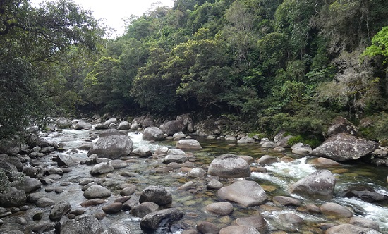
The boulder-strewn Mossman River
After lunch at the Visitor Center, we took the shuttle bus (A$12.65 per person) for a 2-km ride up a one-lane road to the end of a trail alongside the river and a boardwalk called Barral Marrjanga. This translates to "track" "group of Elders" and to the local Eastern Kuku Yalanji people, the rainforest itself is seen as a respected Elder. It would have been interesting if we had had time to take one of the Ngadiku Dreamtime Walks with an Indigenous guide that provide exclusive access to a different part of the rainforest. Instead, we followed the boardwalk to the 2.4-km long Rainforest Circuit Track. Mossman Gorge abuts the southeastern edge of the Daintree National Park, which is part of the largest continuous area of rainforest in Australia.

A cascade of bracket fungi on an old log
The trail weaved through an attractive section of rainforest with plenty of large trees, a variety of fungi, and many calling birds. We did not see as many bird species as we heard, but everyone soon recognized the catbird calls and some of us had a good sighting of a spectacled monarch. The most rewarding sighting, however, was unfortunately missed by all but Randall and me.
The others has continued along the trail as we paused to try to identify a pair of small birds that were fussing around us. It was only once the others were well out of sight that we noticed the cause for the birds' consternation. Without realizing it, we were standing just a few steps away from a nest at head-height just off the trail. When one of the pair alighted on the nest, it was much easier to recognize that they were pale yellow robins. We did not want to cause any more alarm by getting closer, but it looked as though there might be at least two fluffy, brown-headed nestlings. Being the equivalent of mid-February in the northern hemisphere, we realized that spring comes early in this part of Queensland.
A pale yellow robin (to 14 cm or 4 inches) on its compact nest with the heads of possibly two nestlings just showing over the rim
On our way to the start of the Rainforest Circuit Walk, we had passed a popular swimming hole in the Mossman River. There was no lifeguard on duty so swimming was not officially recommended, but it is clearly one of the attractions of the area. Due to the recent rains, there were many temporary warning signs in addition to the usual signs for caution. The most practical, on the shuttle bus, read: "Be wary of flash flooding in the river today. Rain in the catchment could cause river levels to rise quickly. Murky water and leaves floating downriver are the first signs."
People at the Mossman River swimming hole when we first walked past
Quite a few people had been enjoying the swimming hole when we were heading towards the rainforest loop trail. On our return, the site was almost empty, so four of us had a quick dip in the river which still had reassuringly clear water. After our warm walk, the dip was certainly refreshingly, one might even say, bracingly cold.
Jungle perch or flagtail (Kuhlia rupestris - to 45 cm or 14 inches)
There were quite a few medium-sized fish lurking in the swimming hole. They looked quite distinctive but I was not sure if my above-water photographs would be good enough to obtain an identification on iNaturalist. I need not have been concerned, one of the interpretive signs on the River Circuit Track, helpfully identified them as jungle perch or flagtail. Despite their apparent boldness when people were standing on the shore, they quickly dispersed as anyone entered the water, and none of the swimmers' toes were nibbled.
Randall and I concluded that Mossman Gorge was a good place to go for a cool swim on a hot day or if you have never walked in the rainforest before. The Ngadiku Dreamtime Walk might also have been very interesting. However, there was no sign of a steep-sided gorge, which is what we were expecting. So after seeing Tully Gorge and the Hypipamee Crater, that aspect of Mossman Gorge was rather anticlimactic.
Conversely, we were not disappointed by the spectacle of the coastal views along the Captain Cook Highway. When we left Cairns, we had made the correct decision to postpone this part of our trip. Returning to Cairns with a clear sky and the sun starting to sink in the west, provided beautiful conditions for admiring the juxtaposition of the rainforests of the Kuranda National Park and the Great Barrier Reef Coast Marine Park.
Looking south to the Macalister Range from the Rex Viewpoint on the Captain Cook Highway
When we stopped at the Rex Viewpoint we were able to watch someone hang-gliding on the steady updraft of the trade-winds sweeping up the cliffs. As confident as the person looked hang-gliding, they were soon shown how it should really be done, when a white-breasted sea-eagle joined them for a soaring ride in the updraft.

White-breasted sea-eagle showing-off to a hang-glider
While Sue, Graeme, and Jamie returned to their boat, Lynne, Andrew, Randall and I stopped in Cairns to enjoy a lovely meal at Orient Sushi. By the time we had unpacked the car, we were all ready for a good night's sleep. Making the most of the car, the next morning the four of us left the marina to get to the grocery store by 6:30am, particularly to buy bulky and heavy items. After refueling, Randall and I dropped the car off and walked back to the marina. It had been a perfect four-day expedition with delightful company. It had been sufficiently different from last year to keep Randall and me happy, but we had also been able to use our previous experience, along with a large dose of good luck, to find a marvelous of sample of Australian creatures that were new to our appreciative Australian friends. Where to next, Mates?
...Andrew had to attend a Zoom meeting for most of Wednesday morning (18th August), while the rest of us dispersed to participate in the type of activities that he was least likely to want to do. Prior to settling in front of his laptop, Andrew had joined Randall and me for our pre-breakfast walk and bird survey. We took a different road away from the Manor, and our sightings included several golden-headed cisticolas and bush stone-curlews.
After breakfast, Sue, Graeme, and Jamie visited the Historic Village at Herberton where there were many collections of old buildings, vehicles, John Deere equipment, tools, dolls, toys, etc. The intent was to find something that would hold Jamie's interest, but it was evident that Graeme was rather excited about seeing what was in The Tool Shed. Meanwhile, Randall and I took Lynne to see a big hole in the ground and a bunch of birds.
Part of the interpretive sign at Mount Hypipamee National Park
Leaving Andrew at Malanda Manor Guesthouse and following some backroads with attractive views, we arrived at Mount Hypipamee National Park, one of the places that I had particularly wanted to visit. After wandering along a trail through the rainforest, we arrived at what appeared to be a huge sinkhole, about 70 m in diameter (230 feet). Rather than a hole that collapsed downward, we were looking at a volcanic vent, called a diatreme or volcanic pipe (but on the signs, rather confusingly, usually called a crater), which was formed by the explosive release of gases throwing rocks upwards from a side vent of a volcano.
Lynne on the viewing platform at the Mount Hypipamee Crater
The sheer sides of the vent dropped 58 m (190 feet) from the viewing platform to the surface of the water which was covered with a bright green carpet of duckweed. On the far side, the cliffs rose for a similar height above the platform with trees, surrounding the rim and clinging tenaciously to any cracks or ledges large enough to harbor sufficient soil for survival. Below the water surface, the vent descended a further 73 m (240 feet), as had been measured by divers, whose method of entry and exit from the pool must have been quite interesting.
The opposite side of the Mount Hypipamee Crater from the viewing platform with the duckweed covering the water that fills about 56% of the vent below the platform
It was difficult to take pictures that did justice to the impressiveness of this giant tube rising through the mountainside. I had really picked this as a National Park worth visiting because it was mentioned as being good for birding, so the dramatic scenery was better than I had anticipated. And then it seemed that the birds sent an emissary to make sure that we did not ignore them...a peregrine falcon.
Being stared-down by a peregrine falcon (to 48 cm or 19 inches) at Mount Hypipamee volcanic vent
Actually, there were two falcons but we saw one and only heard the other. The one that we saw, came into the crater and circled once, then went up high and started to make a fast dive towards the water. I gasped as it seems unlikely that it was after prey in the duckweed. The dive was aborted below the viewing platform and the magnificent raptor flew up to a branch that was at about the same height as us, but across the crater. It stared at us intently, adjusted a few feathers, responded to its mate calling from behind us, and then launched itself back into the crater. A couple more circles inside the vent to gain altitude, and then it flew over our heads into the forest to follow the calls of its companion.
We had been treated to a few minutes in the presence of majesty. Never have we had such a good views of a peregrine falcon in the wild. It may not have reached a great speed during its short dive into the vent, but there was no mistaking the capability in the throwing back of its wings. Diving peregrine falcons are not only the fastest bird in the world, reaching speeds of more than 320 km (200 miles) per hour, but are the fastest animal on earth. With 16 subspecies recognized, breeding populations of these falcons are found on every continent except Antarctica.
Thoroughly impressed, we continued along the loop trail wondering what else this Park might have to capture our attention. Notable were several huge elkhorn ferns, balanced at our eye-level in trees that scarcely looked strong enough to support them.
A large elkhorn fern
A sign next to a yellow mahogany tree, described the phenomenon of cauliflory, where flowers are borne directly on the tree trunk and older branches. More familiar examples include cocoa, papaya, and jackfruit. Ironically, cauliflowers are strictly not cauliflorous. The specimen near the sign had many clumps of flowers on the trunk but they were rather small and inconspicuous. As is often the way, once we started paying attention, we subsequently saw many better examples with more showy flowers.
Clumps of cauliflorous flowers on the yellow mahogany tree by the interpretive sign in Mount Hypipamee National Park
The adaptive strategy of cauliflory is that bearing flowers and fruit at an intermediate height in the forest can attract pollinators and seed dispersers from both the canopy above and the forest floor below. Cauliflory is beneficial to fruit bats because the flowers and fruit are separated from the network of branches where wings may become entangled.
Cauliflorous yellow mahogany flowers seen later at Mossman Gorge
Although the plants and birds in Mount Hypipamee National Park were keeping us occupied, geology had the last word. Quite separate from the water in the base of the volcanic vent, but not far away, flowed the Barron River. This waterway collects rainfall from a large area of the Atherton Tablelands before descending from the plateau and passing over the Barron Falls near Kuranda. Sadly, we would not have time to take the Kennedy Highway to Kuranda or these Falls, but we were able to see the smaller Dinner Falls in the headwaters of the Barron River. Unlike at Josephine Falls at the foot of the plateau, these Tableland cascades were not particularly full but they were very pleasant. The origin of the name Dinner Falls is uncertain, but possibly relates the three tiers to the three courses of dinner.
The middle tier of Dinner Falls in Mount Hypipamee National Park
This is a slightly less imaginative name origin than is proposed for the National Park itself. From Wikipedia: "The name Hypipamee is a corruption of the Aboriginal word, nabbanabbamee, which is connected with a legend of two young men who cut down a sacred candlenut tree, only to be swallowed up by a large hole in the earth, the crater." On the other hand, the link between "a three-course dinner" and "three tiers" seems a bit more obvious to me than between "Hypipamee" and "nabbanabbamee"...
Leaving the National Park, we drove north to the edge of Atherton, on our way to revisit Hasties Swamp National Park. Before turning off the main road we glimpsed some large grey and red birds in a ploughed field, probably sarus cranes. The road was busy so we did not stop but assumed that we would see some of the cranes at the Swamp, as we did last year.
We were not only wrong to expect the presence of sarus cranes, but the whole waterfowl population of the lake within the Nayleta Wetlands seemed to be different and was apparently much reduced. Instead of the hundreds of hardhead ducks that had covered the lake late last September, we saw quite a large number of magpie geese around the north end but few birds on the open water. We were arriving later in the day than on our previous visit, but it was still worrying that the water fowl population seemed to be so reduced.
Once we climbed into the two-storey bird hide, we wondered where the loud, shrill calls were coming from. There did not seem to be enough birds nearby to sustain that volume of sound. Then we looked down into the wide fringe of aquatic plants and noticed hundreds of brown ducks, mostly napping with their heads turned backwards and tucked under a wing. But enough of them were awake to be making the whistling noises, and a few were swimming along the edge of the vegetation, allowing us to identify quickly them as plumed whistling-ducks.
Plumed whistling-ducks (to 61 cm or 24 inches) showing with their pale plumes
On closer inspection, we noticed quite a few other species around the lake edge but we did not linger and take a bird survey as we needed to return to Malanda and rescue Andrew by lunchtime. Lynne seemed to be suitably impressed, once we had found all the ducks, and I think that we can make a birders of her and Andrew yet!
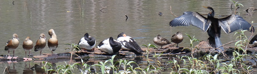
L to R: 4 plumed whistling-ducks, 3 magpie geese, 2 Pacific black ducks, and an Australian darter sharing a log at Hasties Swamp...is this part of an Australian bird-themed Christmas carol?
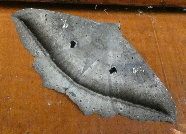
We also noticed a large manically smiley-faced moth in the bird hide which I think is a wood moth (Hulodes caranea).
On our way to pick up Andrew and have lunch in our rooms at Malanda Manor, we stopped briefly at Gallo Dairyland. We were not interested in a tour of the dairy farm or the food production facilities, but we did buy some gourmet chocolates and cheeses that had been made on site. YUM YUM!
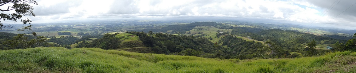
Once we were fed and had collected Andrew, we headed south from Malanda. Stopping briefly to admire the pastoral landscapes from the Millaa Millaa Lookout, we then continued on to Ravenshoe. We had some debate about whether it was Ravens-hoe or Raven-shoe but did not bother to stop and ask (...it is the latter according to the internet).
The view east from Millaa Millaa Lookout with a cloudy sky but much better visibility than the day we arrived from Cairns
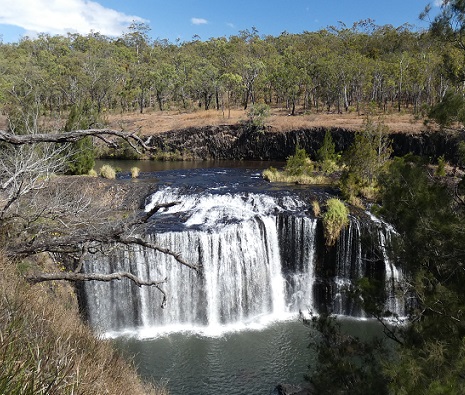
Our first destination of the afternoon was another of my "must see" choices, Big Millstream Falls. They were attractive Falls as the water dropped over the erosion-resistant edge of a columnar basalt lava flow, but the real reason for my interest was that they are "reputed to be" (is nobody quite sure?) the widest single-drop fall in Australia. Actually, I have not been able to find any data online that provides the actual width (or other dimensions) of the Falls. And does this oft-repeated, but apparently unsubstantiated, evaluation of "widest" include the section of falls to the right of the main fall but which are not visible from the viewpoint?
Big Millstream Falls
I estimated that the visible part of these Falls were less than 100 m wide but, as Randall would put it, "that is a wild-ass guess". Regardless of the exact size, this pales into insignificance compared to the 832 m (2,730 feet) width of the Horseshoe Fall at Niagara, Canada, the 1,708 m (5,604 feet) width of Victoria Falls on the Zambia/Zimbabwe border, or the world-record width of 10,783 m (35,377 feet) of the Khone Phapheng Falls in southern Laos. Of course, given how much of Australia's area is extremely dry, the absence of huge rivers with correspondingly wide waterfalls is not surprising.
The open eucalypt forest surrounding the Big Millstream Falls was quite different from the rainforest that we had been walking through on most of our trip so far. The change from wet to dry landscape seemed to occur as we approached Ravenshoe. This region was the traditional country of the Jirrbal Aboriginal people who lived in the rainforest areas in semi-permanent villages. The drier, flatter areas would have been more attractive to the European farmers who extensively settled the Atherton Tablelands.
During World War II, the Tablelands were identified as a suitable area for training and rehabilitation camps for Australian military forces. Close to the battlefields of Papua New Guinea, with a climate cooler than the coast, and environments similar to parts of Southeast Asia, 160 sites were established in 1943. At a given time, up to 100,000 troops from 320 army and ancillary units were located in the Tablelands.
After our stroll down to see the Falls, we followed a loop trail through the open woodland that explored the camp sites that were constructed for the Battalions of the 7th and 9th Divisions between 1943 and 1945. Holding almost 1,000 men, each campsite had mostly tent accommodation and cooking, latrine, and washing facilities. Now, however, there is nothing to see other than some interpretive signs, a stone fireplace, and a few lines of stones that edge the network of rock-lined granite paths and roads that linked the facilities. A pleasant enough woodland amble but rather underwhelming unless you are a WWII buff.
Our next destination, about 26 km (16 miles) to the west, was Innot Hot Springs Scenic Reserve, a site that particularly intrigued Randall. Fractures reach 600 m (almost 2,000 feet) deep in the rocks underlying the sandy alluvial surface sediments of this area. Water seeps down some of the fractures to become heated when in proximity to the volcanic magma chambers. This expanded, pressurized hot water then rises in other fractures, reaching the surface as hot springs. By the 1890s, Innot Hot Springs were so popular and had such alleged medical benefits, that two hotels and a bathhouse were built at the edge, and the water was being bottled in Townsville for export to Europe.
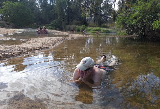
Now there is a large campground next to a wide shallow stream into which the hot springs rise. People dig holes in the sandy sediment in which to bathe, a bit like at Hot Water Beach on the Coromandel Peninsula in New Zealand, but without the refreshment of each high tide. A dozen people were sitting in shallow pools, enjoying the warm waters. Randall boldly flopped into an empty puddle downstream of the other people. Andrew eventually joined him but Lynne and I were not as impressed, put off by the water's very slow flow and green tinge. Maybe on a cold day it might have been tempting...
Randall sort-of enjoying the Innot Hot Springs
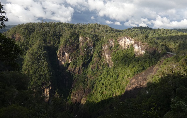
The final spectacle for the day, was at the end of a detour from Ravenshoe, down a windy road through dark rainforest, to the lookout point for Tully Gorge and Falls. The main access for white-water rafting in Tully Gorge is much further downstream, via the town of Tully which is on the coastal highway, and cannot be reached by road directly from this upper viewpoint. This section of the Gorge was deep and impressive, with the top at an elevation of 700 m (2,297 feet), and the depth of the Gorge being 293 m (961 feet).
Tully Gorge, with the base in shade at the bottom; the river is just visible on the right but the falls are hidden behind the trees
The Falls, sadly, were not spectacular as they were almost completely obscured by trees. This was a particular pity because there was a large amount of water in the river, which is unusual at this time of year. Usually there is only plenty of water flowing during the wet season (summer) because the rest of the time, most of the water from Koombooloomba Reservoir is diverted before reaching Tully Falls. It is sent through an underground tunnel to the floor of the gorge, 2km downstream of the Falls, where it feeds into turbines for an 84 MW hydroelectric station. We learned from three young men who arrived to look over the gorge in their muddy work clothes, that the tunnel was closed for maintenance. Once we had started talking, they were happy to explain that they were contracted to clean and maintain the large tunnel. They seemed cheerful enough and hopefully were being paid well but it did not sound like a very pleasant task.
As we drove back along the Tully Falls Road, we were all intrigued to see a large, black boar leaving the roadside and crashing into the undergrowth. Some of the others had seen the same pig at the same spot when we drove in, so it must have found some attractive food there. Feral pigs are not native to Australia (wild boar were native to Eurasia) and, as in many parts of the Americas, are major pests in natural and agricultural ecosystems.
We returned to the Guesthouse for another tasty dinner over which we traded tales of our day's activities with Sue and Graeme. We all turned-in for an early night which allowed us to all be ready to leave the Manor at 8:15 am the next morning, quite an achievement. As we drove towards Atherton, I suddenly asked Andrew to stop on the roadside to show everyone some sarus cranes standing in a ploughed field. Our views were even better when several more flew in and landed with their long legs dangling and huge wings widely flapping.
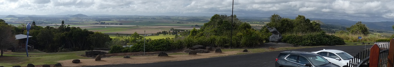
Our next stop was in Atherton at the top of the volcanic cone, Halloran's Hill. The expansive view was mostly over agricultural land dotted with many other conical hills. The horizon was lined by the mountaintops of either the coastal range, including the previously elusive Bartle Frere, or inland to the Great Dividing Range. There was a hiking trail downhill through the Halloran's Hill Conservation Park which Sue and I took part of the way. Sue was hoping to find her 100th geocache site as we left the hilltop but, after a quick search, she could not find it. I was familiar with the term "geocache", a worldwide outdoor treasure-hunting activity in which participants use GPS to hide and find small containers with caches that might have small prizes or just a mechanism to record your presence. I had no idea that the concept had evolved to have so many types of cache and challenges associated with them (e.g., "cache-in trash-out" to combine litter removal with finding caches). I was glad to hear that Sue had another opportunity later that day and, thus, scored her century of caches.
Looking south from Halloran's Hill in Atherton
During our drive north covering most of the length of the Atherton Tablelands, we stopped at the Coffee Works in Mareeba. It seemed to be time to reward those in our group who, unlike Randall and I, are not relentless "morning people". The place was a huge tent-like store with many gifts, household items, gourmet food, coffees, and chocolate for sale. While the others sampled the coffee, I had lime and passionfruit sorbet, and Randall had a diet Coca-Cola. By chance, we had arrived on a day with free tasting of coffee- and chocolate-liqueurs. I volunteered to be designated driver for the next section while Randall happily consumed both his and my tray of five small samples of liqueurs (mostly like Bailey's Irish Cream). Several members of our group were noticeably merrier by the time we left, and the conversation in our car was even more animated and witty...for a while.
We stopped briefly in Mount Malloy to see the bower of a great bower bird. Curiously, it had been moved around the corner of the yard in which Randall and I had seen it last year, but the associated collection of white snail shells and random pink or red items seemed just as large. There was no sign of the male great bowerbird itself, but a man working on the road nearby wandered over to tell us that we were bound to see the bird at the similar bower in Julatten, across from the school. We thanked him and made the short detour into Julatten. We easily found the large bower but, disappointingly, we again missed seeing the bird.
After passing the Kingfisher Park Birdwatchers Lodge and recounting to our captive audience of Lynne and Andrew many of the stories from our stay there, we drove down off the plateau to Mossman. There we turned left to get to the Mossman Gorge Visitor Centre. Described as the "gateway to the Daintree" the Mossman Gorge Centre is "an award-winning ecotourism destination that welcomes 370,000 visitors each year and employs 90 people from May through September, with a 90% Indigenous workforce. But a few decades ago, the Centre was still the dream of Kuku Yalanji elder Roy Gibson. With the support of and funding from the Indigenous Land and Sea Corporation (ILSC), Roy's dream became a reality, and now the Centre supports environmental and economic wellbeing for the entire community." From the Centre's website: https://www.mossmangorge.com.au/about-us
The boulder-strewn Mossman River
After lunch at the Visitor Center, we took the shuttle bus (A$12.65 per person) for a 2-km ride up a one-lane road to the end of a trail alongside the river and a boardwalk called Barral Marrjanga. This translates to "track" "group of Elders" and to the local Eastern Kuku Yalanji people, the rainforest itself is seen as a respected Elder. It would have been interesting if we had had time to take one of the Ngadiku Dreamtime Walks with an Indigenous guide that provide exclusive access to a different part of the rainforest. Instead, we followed the boardwalk to the 2.4-km long Rainforest Circuit Track. Mossman Gorge abuts the southeastern edge of the Daintree National Park, which is part of the largest continuous area of rainforest in Australia.
A cascade of bracket fungi on an old log
The trail weaved through an attractive section of rainforest with plenty of large trees, a variety of fungi, and many calling birds. We did not see as many bird species as we heard, but everyone soon recognized the catbird calls and some of us had a good sighting of a spectacled monarch. The most rewarding sighting, however, was unfortunately missed by all but Randall and me.
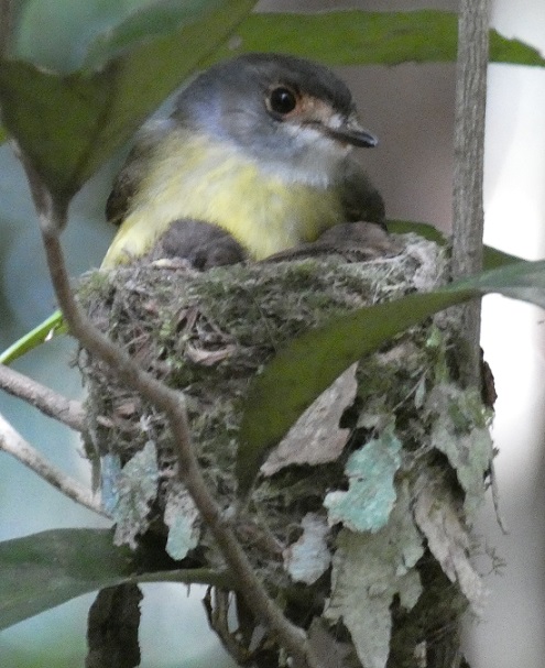
The others has continued along the trail as we paused to try to identify a pair of small birds that were fussing around us. It was only once the others were well out of sight that we noticed the cause for the birds' consternation. Without realizing it, we were standing just a few steps away from a nest at head-height just off the trail. When one of the pair alighted on the nest, it was much easier to recognize that they were pale yellow robins. We did not want to cause any more alarm by getting closer, but it looked as though there might be at least two fluffy, brown-headed nestlings. Being the equivalent of mid-February in the northern hemisphere, we realized that spring comes early in this part of Queensland.
A pale yellow robin (to 14 cm or 4 inches) on its compact nest with the heads of possibly two nestlings just showing over the rim
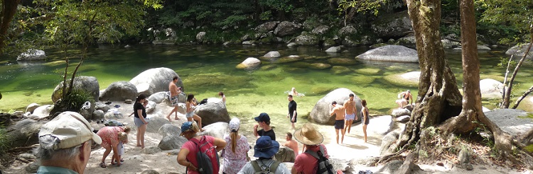
On our way to the start of the Rainforest Circuit Walk, we had passed a popular swimming hole in the Mossman River. There was no lifeguard on duty so swimming was not officially recommended, but it is clearly one of the attractions of the area. Due to the recent rains, there were many temporary warning signs in addition to the usual signs for caution. The most practical, on the shuttle bus, read: "Be wary of flash flooding in the river today. Rain in the catchment could cause river levels to rise quickly. Murky water and leaves floating downriver are the first signs."
People at the Mossman River swimming hole when we first walked past
Quite a few people had been enjoying the swimming hole when we were heading towards the rainforest loop trail. On our return, the site was almost empty, so four of us had a quick dip in the river which still had reassuringly clear water. After our warm walk, the dip was certainly refreshingly, one might even say, bracingly cold.
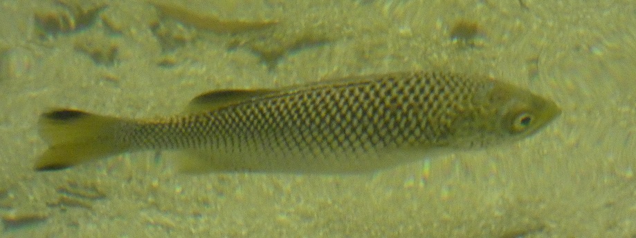
Jungle perch or flagtail (Kuhlia rupestris - to 45 cm or 14 inches)
There were quite a few medium-sized fish lurking in the swimming hole. They looked quite distinctive but I was not sure if my above-water photographs would be good enough to obtain an identification on iNaturalist. I need not have been concerned, one of the interpretive signs on the River Circuit Track, helpfully identified them as jungle perch or flagtail. Despite their apparent boldness when people were standing on the shore, they quickly dispersed as anyone entered the water, and none of the swimmers' toes were nibbled.
Randall and I concluded that Mossman Gorge was a good place to go for a cool swim on a hot day or if you have never walked in the rainforest before. The Ngadiku Dreamtime Walk might also have been very interesting. However, there was no sign of a steep-sided gorge, which is what we were expecting. So after seeing Tully Gorge and the Hypipamee Crater, that aspect of Mossman Gorge was rather anticlimactic.
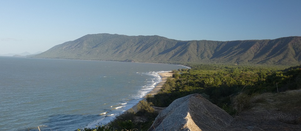
Conversely, we were not disappointed by the spectacle of the coastal views along the Captain Cook Highway. When we left Cairns, we had made the correct decision to postpone this part of our trip. Returning to Cairns with a clear sky and the sun starting to sink in the west, provided beautiful conditions for admiring the juxtaposition of the rainforests of the Kuranda National Park and the Great Barrier Reef Coast Marine Park.
Looking south to the Macalister Range from the Rex Viewpoint on the Captain Cook Highway
When we stopped at the Rex Viewpoint we were able to watch someone hang-gliding on the steady updraft of the trade-winds sweeping up the cliffs. As confident as the person looked hang-gliding, they were soon shown how it should really be done, when a white-breasted sea-eagle joined them for a soaring ride in the updraft.
White-breasted sea-eagle showing-off to a hang-glider
While Sue, Graeme, and Jamie returned to their boat, Lynne, Andrew, Randall and I stopped in Cairns to enjoy a lovely meal at Orient Sushi. By the time we had unpacked the car, we were all ready for a good night's sleep. Making the most of the car, the next morning the four of us left the marina to get to the grocery store by 6:30am, particularly to buy bulky and heavy items. After refueling, Randall and I dropped the car off and walked back to the marina. It had been a perfect four-day expedition with delightful company. It had been sufficiently different from last year to keep Randall and me happy, but we had also been able to use our previous experience, along with a large dose of good luck, to find a marvelous of sample of Australian creatures that were new to our appreciative Australian friends. Where to next, Mates?
Comments
| Vessel Name: | Tregoning |
| Vessel Make/Model: | Morgan Classic 41 |
| Hailing Port: | Gainesville, FL |
| Crew: | Alison and Randall |
| About: | We cast-off from Fernandina Beach in north Florida on 1st June 2008 and we have been cruising on Tregoning ever since. Before buying Tregoning, both of us had been sailing on smaller boats for many years and had worked around boats and water throughout our careers. |
| Extra: | “Tregoning” (rhymes with “belonging”) and is a Cornish word (meaning “homestead of Cohnan” or “farm by the ash trees”) and was Alison's mother’s middle name. Cornwall is in southwest England and is where Alison grew-up. |
Tregoning's Photos - Main
 |
 |
 |
 |
 |
 |
 |
 |
 |
 |
 |
The Sailblogs Prequel: Adding old posts from expired blog
166 Photos
Created 26 May 2020
|
 |
 |
 |
 |
 |
 |
 |
 |
 |
 |
 |
 |
Extra photographs from our three-week campervan tour of the South Island from November 15th to December 5th 2015
217 Photos
Created 4 January 2016
|
 |
Random pictures from our month spent on the islands of Hiva Oa, Tahuata, Ua Pou, and Nuku Hiva
45 Photos
Created 18 July 2015
|
 |
Random pictures from our month spent in 4 Tuamotu Atolls; Ahe, Fakarava, Tahanea, and Toau
32 Photos
Created 1 July 2015
|
 |
Some of the birds, fish, reptiles, and mammals (and others) that we have seen in Mexico
74 Photos
Created 5 May 2014
|
 |
Tregoning
Who: Alison and Randall
Port: Gainesville, FL
Gallery